
Community hub
Recent from talks
Contribute something
Nothing was collected or created yet.
Croydon
View on Wikipedia
Croydon is a large town in South London, England, 9.5 miles (15 km) south of Charing Cross. Part of the London Borough of Croydon, a local government district of Greater London; it is one of the largest commercial districts in Greater London, with an extensive shopping area.[2] The entire town[3] had a population of 192,064 as of 2011, whilst the wider borough had a population of 384,837.[4]
Key Information


Historically an ancient parish in the Wallington Hundred of Surrey, at the time of the Norman Conquest of England Croydon had a church, a mill, and around 365 inhabitants, as recorded in the Domesday Book of 1086.[5] Croydon expanded in the Middle Ages as a market town and a centre for charcoal production, leather tanning and brewing, with the brewing industry in particular remaining strong for hundreds of years.[6] The Surrey Iron Railway from Croydon to Wandsworth opened in 1803 and was an early public railway.[7] Later 19th century railway building facilitated Croydon's growth as a commuter town for London.[8] By the early 20th century, Croydon was an important industrial area, known for car manufacture, metalworking and Croydon Airport.[8][9] In the mid 20th century these sectors were replaced by retailing and the service economy, brought about by massive redevelopment which saw the rise of office blocks and the Whitgift Centre, the largest shopping centre in Greater London until 2008.[10] Historically, the town formed part of the County of Surrey, and between 1889 and 1965 a county borough, but it was amalgamated into Greater London in 1965.[11]
Croydon lies on a transport corridor between central London and the south coast of England, to the north of two high gaps in the North Downs, one taken by the A23 Brighton Road and the main railway line through Purley and Merstham and the other by the A22 from Purley to the M25 Godstone interchange.[8] Road traffic is diverted away from a largely pedestrianised town centre, mostly consisting of North End. East Croydon railway station is a hub of the national railway system, with frequent fast services to central London, Brighton and the south coast.[8] The town is also at the centre of the only tramway system in Southern England.[12]
Toponymy
[edit]
As the vast majority of place names in the area are of Anglo-Saxon origin, the theory accepted by most philologists is that the name Croydon derives originally from the Old English croh, meaning "crocus", and denu, "valley", indicating that, like Saffron Walden in Essex, it was a centre for the cultivation of saffron.[14][15] It has been argued that this cultivation is likely to have taken place in the Roman period, when the saffron crocus would have been grown to supply the London market, most probably for medicinal purposes, and particularly for the treatment of granulation of the eyelids.[16]
Alternative, but less probable, derivations have been proposed. Andrew Coltee Ducarel suggested that the name came from the Old French for "chalk hill". John Corbet Anderson refuted this on the grounds that the name was in use at least a century before the Norman Conquest, which is when the French language began to be commonly used in England.[17]
Anderson himself proposed that the name might mean a "crooked valley":
The earliest mention of Croydon is in the joint will of Beorhtric and Aelfswth, dated about the year 962. In this Anglo-Saxon document the name is spelt [here he uses Old English characters], Crogdaene. Crog was, and still is, the Norse or Danish word for crooked, which is expressed in Anglo-Saxon by crumb, a totally different word. From the Danish came our crook and crooked. This term accurately describes the locality; it is a crooked or winding valley, in reference to the valley that runs in an oblique and serpentine course from Godstone to Croydon.[17]
However, there was no long-term Danish occupation in Surrey, which was part of Wessex, and Danish-derived nomenclature is also highly unlikely.
More recently, David Bird, while accepting the derivation from the word crocus, has speculated that this might actually be a personal name, Crocus. He suggests a family connection with the documented Chrocus, king of the Alemanni, who allegedly played a part in the proclamation of Constantine as emperor at York in AD 306.[16]
History
[edit]Early history
[edit]The town lies on the line of the Roman road from London to Portslade, and there is some archaeological evidence for small-scale Roman settlement in the area: there may have been a mansio (staging-post) here.[18][19][20][21][22] Later, in the 5th to 7th centuries, a large pagan Saxon cemetery was situated on what is now Park Lane, although the extent of any associated settlement is unknown.[23][24]
By the late Saxon period Croydon was the hub of an estate belonging to the Archbishops of Canterbury. The church and the archbishops' manor house were situated in the area still known as "Old Town". The archbishops used the manor house as an occasional place of residence: as lords of the manor they dominated the life of the town well into the early modern period, and as local patrons they continue to have an influence.[25] Croydon appears in Domesday Book (1086) as Croindene, held by Archbishop Lanfranc. Its Domesday assets included 16 hides and 1 virgate of land; a church; a mill worth 5s; 38 plough-teams; 8 acres (3.2 ha) of meadow; and woodland for 200 hogs. It had a recorded population of 73 households (representing roughly 365 individuals); and its value in terms of taxes rendered was £37 10s 0d.[26][5]

The church had been established in the middle Saxon period, and was probably a minster church, a base for a group of clergy living a communal life. A charter issued by King Coenwulf of Mercia refers to a council that had taken place close to the monasterium (meaning minster) of Croydon.[29] An Anglo-Saxon will made in about 960 is witnessed by Elfsies, priest of Croydon; and the church is also mentioned in Domesday Book.[5] The will of John de Croydon, fishmonger, dated 6 December 1347, includes a bequest to "the church of S John de Croydon", the earliest clear record of its dedication.[30] The church still bears the arms of Archbishop Courtenay and Archbishop Chichele, believed to have been its benefactors.[31]

In 1276 Archbishop Robert Kilwardby acquired a charter for a weekly market, and this probably marks the foundation of Croydon as an urban centre.[32] Croydon developed into one of the main market towns of north-east Surrey. The market place was laid out on the higher ground to the east of the manor house in the triangle now bounded by High Street, Surrey Street and Crown Hill.[33] By the 16th century the manor house had become a substantial palace, used as the main summer home of the archbishops and visited by monarchs and other dignitaries. However, the palace gradually became dilapidated and surrounded by slums and stagnant ponds, and in 1781 the archbishops sold it, and in its place purchased a new residence at nearby Addington. Nevertheless, many of the buildings of the original Croydon Palace survive, having been occupied from 1889 to 2025 by Old Palace School.[34]


The parish church (now Croydon Minster) is a Perpendicular-style church, remodelled in the 1850s but destroyed in a great fire in 1867, after which only the tower, south porch, and outer walls remained.[36] A new church was designed by Sir George Gilbert Scott, one of the greatest architects of the Victorian age, and opened in 1870. His design loosely followed the previous layout, with knapped flint facing and retaining many of the original features, including several tombs. The church is the burial place of six Archbishops of Canterbury: John Whitgift, Edmund Grindal, Gilbert Sheldon, William Wake, John Potter and Thomas Herring.[30] Historically part of the Diocese of Canterbury, Croydon is now in the Diocese of Southwark.[37] In addition to the suffragan Bishop of Croydon, the Vicar of Croydon is a preferment.[38]


Addington Palace is a Palladian-style mansion between Addington Village and Shirley, in the London Borough of Croydon.[39] Six archbishops lived there between 1807 and 1898, when it was sold.[39] Between 1953 and 1996 it was the home of the Royal School of Church Music. It is now a conference and banqueting venue.[40]
Croydon was home to the Addiscombe Military Seminary (1809–1861), at which young officers were trained for the army of the East India Company.[41]
Croydon was a leisure destination in the mid 19th century. In 1831, one of England's most prominent architects, Decimus Burton, designed a spa and pleasure gardens below Beulah Hill and off what is now Spa Hill in a bowl of land on the south-facing side of the hill around a spring of chalybeate water. Burton was responsible for the Beulah Spa Hotel (demolished around 1935) and the layout of the grounds.[42] Its official title was The Royal Beulah Spa and Gardens. It became a popular society venue attracting crowds to its fêtes. One widely publicised event was a "Grand Scottish Fete" on 16 September 1834 "with a tightrope performance by Pablo Fanque, the black circus performer who would later dominate the Victorian circus and achieve immortality in the Beatles song, Being for the Benefit of Mr. Kite!"[43] The spa closed in 1856 soon after the opening nearby of the Crystal Palace[44] which had been rebuilt on Sydenham Hill in 1854, following its success at the Great Exhibition in Hyde Park.[45]
Horse racing in the area took place occasionally, notably during visits of Queen Elizabeth I to the archbishop. Regular meetings became established first on a course at Park Hill in 1860 and from 1866 at Woodside, where particularly good prizes were offered for the races run under National Hunt rules. In that sphere its prestige was second only to Aintree, home of the Grand National. Increasing local opposition to the presence of allegedly unruly racegoers coupled with the need to obtain a licence from the local authority led to it being closed down in 1890.[46]

The Elizabethan Whitgift Almshouses, the "Hospital of the Holy Trinity", in the centre of Croydon at the corner of North End and George Street, were erected by Archbishop John Whitgift. He petitioned for and received permission from Queen Elizabeth I to establish a hospital and school in Croydon for the "poor, needy and impotent people" from the parishes of Croydon and Lambeth. The foundation stone was laid in 1596 and the building was completed in 1599.[47]
The premises included the Hospital or Almshouses, providing accommodation for between 28 and 40 people, and a nearby schoolhouse and schoolmaster's house. There was a Warden in charge of the well-being of the almoners. The building takes the form of a courtyard surrounded by the chambers of the almoners and various offices.[47]
Threatened by various reconstruction plans and road-widening schemes, the Almshouses were saved in 1923 by intervention of the House of Lords. On 21 June 1983, Queen Elizabeth II visited the Almshouses and unveiled a plaque celebrating the recently completed reconstruction of the building. On 22 March each year the laying of the foundation stone is commemorated as Founder's Day.[47]
In 1864, the Catholic St Mary's Church in Croydon was opened. It was designed by E. W. Pugin and Frederick Walters in the Gothic Revival style. The Grade II listed West Croydon Baptist Church was built in 1873 by J. Theodore Barker. It is a red brick building with stone dressings. Its three bays are divided by paired Doric pilasters supporting a triglyph frieze and panelled parapet.[48] The Parish Church of St Michael and All Angels by John Loughborough Pearson in West Croydon was built between 1880 and 1885, and is Grade I listed.[48]
Industrial Revolution and the railway
[edit]
The development of Brighton as a fashionable resort in the 1780s increased Croydon's importance as a halt for stage coaches on the road south of London. At the beginning of the 19th century, Croydon became the terminus of two pioneering commercial transport links with London. The first, opened in 1803, was the horse-drawn Surrey Iron Railway from Wandsworth, which in 1805 was extended to Merstham, as the Croydon, Merstham and Godstone Railway. The second, opened in 1809, was the Croydon Canal, which branched off the Grand Surrey Canal at Deptford. The London and Croydon Railway (an atmospheric and steam-powered railway) opened between London Bridge and West Croydon in 1839, using much of the route of the canal (which had closed in 1836). Other connections to London and the south followed.
The arrival of the railways and other communications advances in the 19th century led to a 23-fold increase in Croydon's population between 1801 and 1901.[14] This rapid expansion of the town led to considerable health problems, especially in the damp and overcrowded working class district of Old Town. In response to this, in 1849 Croydon became one of the first towns in the country to acquire a local board of health. The Board constructed public health infrastructure including a reservoir, water supply network, sewers, a pumping station and sewage disposal works. The Surrey Street Pumping Station is Grade II listed; it was built in four phases. starting with the engine house in 1851, with a further engine house in 1862, a further extension in 1876–7 to house a compound horizontal engine and a further extension in 1912.[49]
A growing town
[edit]

In 1883 Croydon was incorporated as a borough. In 1889 it became a county borough, with a greater degree of autonomy.[50] The new county borough council implemented the Croydon Improvement scheme in the early 1890s, which widened the High Street and cleared much of the "Middle Row" slum area. The remaining slums were cleared shortly after Second World War, with much of the population relocated to the isolated new settlement of New Addington. New stores opened and expanded in central Croydon, including Allders, Kennards and Grade II listed Grants, as well as the first Sainsbury's self-service shop in the country.[14] There was a market on Surrey Street.[51]

Croydon was the location of London's main airport until the Second World War. During the war, much of central Croydon was devastated by German V-1 flying bombs and V-2 rockets, and for many years the town bore the scars of the destruction. After the war, Heathrow Airport superseded Croydon Airport as London's main airport, and Croydon Airport quickly went into a decline, finally closing in 1959.
By the 1950s, with its continuing growth, the town was becoming congested, and the Council decided on another major redevelopment scheme. The Croydon Corporation Act was passed in 1956. This, coupled with national government incentives for office relocation out of Central London, led to the building of new offices and accompanying road schemes through the late 1950s and 1960s, and the town boomed as a business centre in the 1960s, with many multi-storey office blocks, an underpass, a flyover and multi-storey car parks. The redeveloped town centre has since been identified as an "edge city" – a significant urban and commercial centre in its own right, located on the outskirts of a larger metropolitan area (in this case, London).[52][53]
In 1960 Croydon celebrated its millennium with a pageant held at Lloyd Park and an exhibition held at the old Croydon Aerodrome.
Modern Croydon
[edit].jpg)
The growing town attracted many new buildings. The Fairfield Halls arts centre and event venue opened in 1962. Croydon developed as an important centre for shopping, with the construction of the Whitgift Centre in 1969. No. 1 Croydon (formerly the NLA Tower)[54] designed by Richard Seifert & Partners was completed in 1970. The Warehouse Theatre opened in 1977.
The 1990s saw further changes intended to give the town a more attractive image. These included the closure of North End to vehicles in 1989 and the opening of the Croydon Clocktower arts centre in 1994. An early success of the centre was the "Picasso's Croydon Period" exhibition of March–May 1995.
The Croydon Tramlink began operation in May 2000 (see Transport section below).
The Prospect West office development was built in 1991 to 1992, and its remodelling planned in 2012[55] has now been completed. Renamed Interchange Croydon when it was reopened in 2014, the 180,000 square foot office development was the first new grade A office development of its size to open in Croydon for more than 20 years.[56]
Another large shopping centre, Centrale, opened in 2004 opposite the Whitgift Centre, and adjoining the smaller Drummond Centre. House of Fraser and Debenhams are the anchor stores in the combined centre. In addition, there are plans for a large, new one billion pound shopping centre, in the form of a new Westfield shopping mall to add to the two which the company currently has in Greater London; Westfield plans to work jointly with Hammerson and to incorporate the best aspects of the two companies' designs.[57] In November 2017, Croydon Council gave permission for the new Westfield shopping centre to be built[58] and in January 2018, the Mayor of London, Sadiq Khan, approved the regeneration scheme.[59] Work to demolish the existing Whitgift Centre was due to begin in 2018 and Westfield Croydon was initially to open by 2022. The Westfield plans were delayed and the planning permission elapsed: however, in 2021, Croydon Council confirmed they were committed to see the Westfield Centre proceed.[60] There are several other major plans for the town including the redevelopment of the Croydon Gateway site; and extensions of Tramlink to Purley Way, Streatham, Lewisham and Crystal Palace.

Croydon has many tall buildings such as the former Nestlé Tower (St George's House). The London Borough of Croydon's strategic planning committee in February 2013 gave the go-ahead to property fund manager Legal and General Property's plans to convert the empty 24-storey St George's House office building, occupied by Nestlé until September 2012, into 288 flats.[62]
In 2007, events were held under the label of Croydon Exp07 to promote billions of pounds of promised projects, including swimming pools and a library.[63] However, plans for a new shopping centre, to be called Park Place, had already been abandoned amid a scandal about cash for peerages.[64][65] Also abandoned were plans for an arena near the East Croydon station, after a compulsory purchase order was rejected in 2008 at Cabinet level.[66][67]
On 22 November 2011, then Mayor of London Boris Johnson announced £23m of additional funding to help redevelop the town at the Develop Croydon Conference.[68]
Several apartment developments, for instance Altitude 25 (completed 2010), have been built in recent years, and several more are being built or planned. The construction of Saffron Square,[61] which includes a 43-storey tower, began on Wellesley Road in 2011 and was completed in 2016. Other developments with towers over 50 floors high have been given planning approval. These include the 54-storey "Menta Tower" in Cherry Orchard Road near East Croydon station, and a 55-storey tower at One Lansdowne Road, on which construction was set to begin in early 2013. The latter is set to be Britain's tallest block of flats, including office space, a four-star hotel and a health club.[69]
In May 2012 it was announced that Croydon had been successful in its bid to become one of twelve "Portas Pilot" towns and would receive a share of £1.2m funding to help rejuvenate its central shopping areas.[70]

In November 2013, Central Croydon MP Gavin Barwell gave a presentation at a public meeting on the Croydon regeneration project, detailing various developments underway due to be completed in coming years.[71]
On 26 November 2013, Croydon Council approved a redevelopment of the Town Centre by The Croydon Partnership, a joint venture by the Westfield Group and Hammerson.[72][73] London Mayor Boris Johnson approved the plan the following day.[74] The Croydon Advertiser listed the approval as an "Historic Night for Croydon".[75]
At Ruskin Square, a Boxpark made of sea containers opened in 2016 as a temporary measure until new buildings are constructed for shops, offices and housing.[76][77] The London Evening Standard said that this and other developments were reviving the town which was in the process of gentrification.[78]
Future
[edit]A Croydon Vision 2020 plan was drawn up by Croydon Council after a 1999 study by town planning consultants EDAW.[79] The plan includes new office blocks, apartment buildings, shopping centres and other developments, some of which have already been built. More than 2,000 new homes are planned.[80][81]
A redeveloped Fairfield Halls has been planned to be the linchpin of a cultural quarter encompassing nearby College Green.[82][83] Plans include an art gallery, a new college, shops and offices, with a multi-storey car park set for demolition to make space for 218 homes.[84]
Economy
[edit]As of 2011, Croydon's annual retail turnover from comparison goods was £353 million, the fifth-highest in Greater London behind the West End, Shepherd's Bush, Stratford and Kingston upon Thames. Croydon had as of 2012 320,991 square metres (3,455,120 sq ft) of total town centre floorspace, the second highest in Greater London only behind the West End.[85]
Apart from its large central shopping district, Croydon has a number of smaller shopping areas, especially towards the southern end of the town in which are many restaurants. As of 2011, two of Croydon's restaurants were listed in The Good Food Guide.[86]
In a 2015 study by CACI, Croydon was ranked 12th in the "Hot 100 UK retail locations" with a score of 90%.[87]
The Zotefoams company has its headquarters in Croydon.
Government
[edit]
Status
[edit]For centuries the area lay within the Wallington hundred, an ancient Anglo-Saxon administrative division of the county of Surrey.[88] In the later Middle Ages – probably from the late 13th century onwards – residents of the town of Croydon, as defined by boundary markers known as the "four crosses", enjoyed a degree of self-government through a town court or portmote, and a form of free tenure of property.[89] These privileges set the area of the town apart from its rural hinterland, where the more usual and more restrictive rules of manorial tenure applied. However, Croydon did not hold any kind of formal borough status.
In 1690, the leading inhabitants petitioned William III and Mary for Croydon to be incorporated as a borough. The application was initially approved, the king authorising the drafting of a charter, but the process was then abruptly halted, apparently through the intervention of Archbishop John Tillotson, who probably feared a threat to his own authority over the town. The application was revived the following year, when Queen Mary again authorised a charter, but once again it was abandoned. A second petition in 1707 was effectively ignored.[90][91]
Croydon's growth in the 19th century brought the issue of incorporation back on to the political agenda, and in 1883 the ancient parish of Croydon, apart from its exclave of Croydon Crook or Selsdon, was created a municipal borough within Surrey. In 1889, because the population was high enough, it was made a county borough, exempt from county administration.
In 1965 (under the terms of the London Government Act 1963) the County Borough of Croydon was abolished and the area was transferred to Greater London and combined with the Coulsdon and Purley Urban District to form the London Borough of Croydon.
The borough has on several occasions sought city status. (This would be a purely honorific change of title, making no practical difference to the borough's governance).[92] A draft petition was submitted by the County Borough to the Home Office in 1951, a more formal petition in 1954, and two more applications in 1955 and 1958. When the London Borough was created in 1965, the Council endeavoured to have it styled a City, as was the City of Westminster. Further bids for city status were made in 1977, 1992, 2000, 2002, and 2012. All have failed. The borough's predominant argument has always been its size: in 2000 it pointed out that it was "the largest town which does not have the title of City in the whole of Western Europe". The grounds on which it has been turned down have invariably been that it is (as was stated in 1992) merely "part of the London conurbation, rather than a place with a character and identity of its own". Undeterred, council representatives have more than once described Croydon as "a city in all but name".[93][94] In 2008, Boris Johnson, then Mayor of London, said he would support Croydon being awarded city status.[95]
Modern governance
[edit]The London Borough of Croydon has a Labour-controlled council with 41 Labour councillors and 29 Conservative councillors elected on 3 May 2018.[Corrected Aug 2020]
Until 2024
[edit]Most of the town centre lies within the Addiscombe and Fairfield wards, which form part of the Croydon Central constituency.[96] The rest of the town centre is in the Croham ward, which is part of the Croydon South constituency. These wards are all in the London Borough of Croydon, which is responsible for services along with other agencies such as education, refuse collection, road maintenance, local planning and social care. The Addiscombe ward is currently represented by Labour Councillors . The Fairfield and Croham wards have, by contrast, habitually elected Conservative members. The sitting Member of Parliament for Croydon Central is Sarah Jones, a member of the Labour Party. The sitting Member of Parliament for Croydon South is Chris Philp, a member of the Conservatives. The Member of Parliament for Croydon North is Steve Reed, for the Labour Party.
Since 2024
[edit]From 1974 to 2024, Croydon was represented by three MPs. Under the 2023 Periodic Review of Westminster constituencies, Croydon is now covered by four parliamentary constituencies from the 2024 general election: Croydon East, Croydon West, Croydon South and Streatham and Croydon North.[97]
Public services
[edit]The territorial police force is the Metropolitan Police. Their Croydon Police Station is on Park Lane opposite the Croydon Flyover.[98]
The statutory fire and rescue service in Croydon is the London Fire Brigade (LFB) who have a fire station in Old Town, with two pumping appliances.[99]
The nearest hospital is Croydon University Hospital (known from 1923 to 2010 as Mayday Hospital) in nearby Thornton Heath, which is part of Croydon Health Services NHS Trust.[100] The London Ambulance Service provides the ambulance service.[101]
Demography and population
[edit]The town of Croydon includes its neighbourhoods Addiscombe East, Addiscombe West, Bensham Manor, Broad Green, Coulsdon, Crystal Palace and Upper Norwood, Fairfield, Kenley, New Addington North, New Addington South, Norbury and Pollards Hill, Old Coulsdon, Park Hill and Whitgift, Purley and Woodcote, Sanderstead, Selhurst, Selsdon and Addington Village, Selsdon Vale and Forestdale, Shirley North, Shirley South, South Croydon, South Norwood, Thornton Heath, Waddon, West Thornton and Woodside.[8]
Croydon is ethnically diverse.[102] Those who are from BAME minority background range from 19.5% in Sanderstead ward to 68.6% in Broad Green. West Thornton ward (part of Thornton Heath) is one of the most ethnically diverse areas of England.[103]
Fairfield ward, which is the major ward covering the central town, was ethnically 40% White British, 16% Indian, and 10% Other White in the 2011 UK Census.[104] Religiously, 46% was Christian, 21% irreligious, 13% Hindu and 8% Muslim. The most common household tenure type was either owned or privately rented. The median age was 33. In addition, the Broad Green ward was ethnically 23% White British, 13% Indian, 13% Other Asian, and 11% Black African. About 41% of household tenures were owned, while privately and socially rented each made up 29% each. The median age was 31.[105] The Addiscombe ward was ethnically 45% White British and 10% Other White. Religiously, 52% of the population was Christian, 24% irreligious, 7% Muslim and 6% Hindu. 52% of house tenures were owned.[106] There are 10 other wards that cover Croydon's neighbourhoods.[8]
The median house price as of 2014 was £212,998 in Selhurst ward, one of London's lowest. The highest in the town was in Sanderstead ward, £392,500. The mean age in 2013 ranged from 32 years in Broad Green and Fieldway wards, to 43.2 years in Selsdon and Ballards ward.[107]
| Year of census | Population changes |
|---|---|
| 1811 | +1971 |
| 1821 | +1687 |
| 1831 | +2473 |
| 1841 | +3641 |
| 1851 | +2426 |
| 1861 | +9263 |
| 1871 | No Data |
| 1881 | No Data |
| 1891 | +25,971 |
| 1901 | No Data |
| 1911 | No Data |
| 1921 | +25,059 |
| 1931 | +52,084 |
| 1941 | War[N 1] |
| 1951 | War[N 2] |
| 1961 | +9,456 |
| 1971 | +35,733 |
| 1981 | −35,573 |
| 1991 | +2,321 |
| 2001 | +16,901 |
| 2011 | +32,954 |
| Ward | Detached | Semi-detached | Terraced | Flats and apartments[109][110] |
|---|---|---|---|---|
| Addiscombe | 3.4% | 13.6% | 35.7% | 47.2% |
| Ashburton | 10.8% | 36.8% | 34.4% | 18.0% |
| Broad Green | 4.8% | 18.1% | 34.1% | 42.9% |
| Croham | 18.9% | 15.8% | 16.2% | 49.1% |
| Fairfield | 9.1% | 7.0% | 14.5% | 69.4% |
| Fieldway | 2.8% | 25.7% | 37.1% | 34.4% |
| Heathfield | 13.3% | 30.8% | 29.2% | 26.8% |
| New Addington | 2.6% | 50.2% | 21.8% | 25.2% |
| Sanderstead | 37.8% | 44.7% | 5.2% | 12.2% |
| Selhurst | 4.4% | 16.3% | 26.7% | 52.7% |
| Selsdon and Ballards | 24.4% | 57.6% | 11.7% | 6.3% |
| Shirley | 15.5% | 42.3% | 16.9% | 25.3% |
| Waddon | 5.9% | 24.5% | 23.5% | 46.1% |
| By property type | Number of sales last 12 months |
Average price achieved in last 12 months |
Average price change per unit area |
|---|---|---|---|
| Detached | 161 | £721,706 | 7.1% |
| Semi-detached | 503 | £512,064 | 5.9% |
| Terraced | 789 | £427,405 | 8.2% |
| Flats/apartments | 898 | £261,340 | 3.6% |
Geography
[edit]


.jpg)
Croydon town centre is near the centre of the borough of Croydon, to the north of the North Downs and the Pilgrims' Way path. To the north of Croydon are typical London districts, whereas a short distance southeast (such as Coombe and Selsdon) is green, hilly and rural land. To the west are industrial areas, part of which are in the London Borough of Sutton. The southern suburbs are mainly affluent and also hilly.
The town centre is bordered by Waddon immediately southwest of central Croydon. To the west, inside the London Borough of Sutton lies Beddington. To the north are Broad Green, Thornton Heath and Selhurst. To the south lies South Croydon, and going further south are Purley and Sanderstead. To the east lie Addiscombe and Shirley.
Croydon High Street runs from South Croydon up to the point where it meets the street called North End. North End is the main shopping street, while Croydon High Street is the main restaurant quarter.
The High Street is also home to Wrencote House, a Grade II* listed building. Dating from the late 17th or early 18th centuries, and probably built as a merchant's house, it has a distinctive "H" plan form over its four floors (including basement and attic storey). External features include a rich red brick facade with black headers, and a heavily carved and enriched wooden eaves cornice.[112][113]
Wellesley Road on the A212 road forms a north–south axis through the town centre. In line with London Plan policy, there have been a number of proposals to create greater integration between East Croydon station, which lies on one side of the A212, and the town centre of Croydon, which lies on the other side of it. Croydon Vision 2020 aims to tackle this though such solutions as making the road easier for pedestrians to cross by creating a centre island pathway.
Topographically, central Croydon generally lies between 50 metres (160 ft) (in the north) and 70 metres (230 ft) (in the south) above sea level. Elevation significantly climbs towards the east of the town – Coombe Park peaks at about 95 metres (312 ft) above sea level, whereas the Addington Hills, Coombe Wood and Addington Golf Course are as high as 145 metres (476 ft), with the southern end of New Addington having an elevation of over 160 metres (520 ft). To the south, Croham Hurst has a hill of 145 metres (476 ft), and the highest area of Croydon is the Sanderstead Plantation at 175 metres (574 ft). The lowest elevation is around Broad Green, about 35 metres (115 ft) above sea level.
River Wandle
[edit]The River Wandle is a tributary of the River Thames, flowing some 9 miles (14 km) to Wandsworth and Putney from its source in Croydon. It roughly forms the borough's western boundary with the London Borough of Sutton, and for part of its length also forms the boundary between the London Boroughs of Croydon and Lambeth. One of its tributaries rises in Selhurst.
Culture
[edit]Arts
[edit]
.jpg)
There are several arts venues. Foremost is the Fairfield Halls, opened in 1962, which consists of a large concert hall frequently used for BBC recordings, the Ashcroft Theatre and the Arnhem Gallery. Fairfield is the home of the London Mozart Players. Many famous faces have appeared at the Fairfield Halls, including the Beatles, Bucks Fizz, Omid Djalili, Robert Cray, JLS, Chuck Berry, B. B. King, Don McLean, The Monkees, Johnny Cash, Dionne Warwick, Gladys Knight, Morecambe and Wise, Tom Jones, The Stylistics, Status Quo, Level 42, A-HA, John Mayall, Jools Holland, Kenny Rogers, James Last, and Coolio. The main concert hall was used for the conference scene in the Ron Howard film The Da Vinci Code (2006). The Fairfield Halls reopened in 2019, following a programme of modernisation and refurbishment. Prior to the construction of The Fairfield Halls theatre entertainment was provided by the Theatre Royal (1868–1959) based on the high street on a site previously housing a venue known as 'the theatre'.[114]

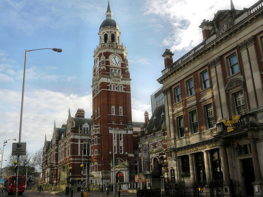
Croydon Clocktower, developed by the London Borough of Croydon in the mid-1990s, houses a state-of-the-art library, a performance venue in the old reference library, the David Lean Cinema (a small, independent, art-house cinema) and the Museum of Croydon, which details Croydon's history. The building links into Croydon Town Hall and some areas of the building, most notably the Braithwaite Hall, are part of the original town hall and library complex, built in 1892–1896 to a design by Charles Henman.[115] A bronze statue of Queen Victoria was erected outside the buildings in 1903.[116]
The Warehouse Theatre (which closed in 2012), was a studio theatre known for promoting new writing, comedy and youth theatre. It had to close because of the major Ruskin Square redevelopment, but will re-open in the future in a new larger theatre building within the new development.[117]
The Pembroke Theatre had many productions with well-known actors before its closure in about 1962.
There are several local and small venues for comedy and community events dotted around Croydon and its districts. Croydon Youth Theatre Organisation celebrated its 40th birthday in 2005. There are several community arts groups, particularly in the large Asian community.
The Spread Eagle Theatre is a new 50-seat studio theatre. Opened in October 2013, it is situated in the town centre, 10 minutes' walk from East Croydon Station. The Spread Eagle works closely with its sister venue, the Old Joint Stock Theatre in Birmingham. Both venues champion 'big plays for small spaces' with an emphasis on new writing, supporting emerging artists and theatre companies.
A calendar titled "Rare Roundabouts of Croydon", with a picture of a different Croydon roundabout each month, has enjoyed some success.[118]
Public art
[edit]
About 60 murals were added to Croydon town centre in 2018, as part of the Rise street art festival coordinated by the Rise art gallery in Croydon.[119][120]
Literature
[edit]Croydon is the setting of two poems by British Poet Laureate Sir John Betjeman, "Croydon" and "Love in a Valley".
The borough has been the residence of many renowned authors and novelists, including Sir Arthur Conan Doyle, who set up house in Norwood, D.H. Lawrence, and French novelist Émile Zola, who lived for a time in the Queen's Hotel, Upper Norwood. Cicely Mary Barker, author and illustrator of the Flower Fairies series of books, was born in Croydon.
Croydon is the setting of various novels. The now defunct airport lent itself to the mysteries The 12.30 from Croydon and Death in the Clouds,[121] and the town is mentioned in some Sherlock Holmes mysteries.
Croydon is referred to in a rhyme dating back to the 18th century, revised in the Victorian era to:
In Jane Austen's unfinished novel The Watsons (written c.1803–1805), the heroine, Emma Watson, has a brother and sister-in-law who live in Croydon, and who urge her to join them for an extended visit. Another sister, Elizabeth, encourages the idea, commenting "there is always something lively going on at Croydon". It would appear that the plot was intended to continue with Emma moving to Croydon.[123][124]
Music
[edit]The composer Samuel Coleridge-Taylor (1875–1912) lived at 30 Dagnall Park, Selhurst, until his death. He grew up in Croydon and sang in the church choir at St George's and taught at the Crystal Palace School of Music and many other schools of music. He died from pneumonia after collapsing at West Croydon station. There is an impressive grave with a poem at Bandon Hill Cemetery, and exhibits about him in the Museum of Croydon.
Addington Palace housed The Royal School of Church Music from 1953 to 1996, when it moved to Salisbury.[125]
In addition to the Fairfield Halls, several venues in Croydon have hosted rock acts. Established in 1976, the Cartoon was a popular live music venue that closed in 2006. The Greyhound in Park Lane played host to acts such as Led Zeppelin, Jimi Hendrix, The Who, David Bowie, Queen, Siouxsie and the Banshees, The Damned, The Boomtown Rats, A-ha in (1987) and others during the 1960s and '70s. Mott The Hoople paid tribute to the town's music scene in the song Saturday Gigs.[citation needed] The Greyhound also saw the debut of the Electric Light Orchestra in 1972.[126]
In the punk era Croydon had its own scene including bands such as Johnny Moped, which at one point had member Captain Sensible who later released the song "Croydon" in 1982 in tribute to his home town.[127][128]
Croydon has been at the centre of the development of the dubstep genre, a relatively recent musical development that traces its roots from Jamaican dub music, UK Garage and drum and bass. Artists such as Benga and Skream, who honed their production and DJing skills whilst working at the now defunct Big Apple Records on Surrey Street,[129] along with Norwood's Digital Mystikz, DJ Chef, and Thornton Heath's Plastician, form the core roster of dubstep DJs and producers. Moreover, UK rappers and grime artists Stormzy, Krept and Konan, all hail from or can trace their roots to the London Borough of Croydon.
In 1993, Music Week reported that Croydon's record shops were thriving.[130] The town centre was for 30 years home to Europe's largest second-hand record store, Beano's, offering rare vinyl, CDs and books. In November 2008, it was announced that Beano's would close. The premises, off Church Street near the Grant's cinema complex, became a "market place" with stalls for rent by small business and individuals.[131]
Continuing Croydon's tradition of dubstep record shops, are Reggaemasters, which opened in 2004 on Drummond Road and moved to Frith Road in 2019,[132] and Addiscombe's DnR Vinyl, which cites Big Apple Records as its main inspiration.[133] Ten Pin Records opened in Purley in 2022.[134]
The oldest currently surviving shop in Croydon is 46 South End, which is a music shop. Dating back to the 16th century, this Grade II listed building still retains all its original Tudor features. Records show that the premises has been a shop for at least 163 years, where street directories from 1851 give the names of E. C. Johnson & Thorpe.[135]
Croydon is home to the BRIT School for performing arts and technology, based in Selhurst, which has produced stars such as Adele, Jessie J, Amy Winehouse, Leona Lewis, Katie Melua, Katy B, Kate Nash, Imogen Heap, Rizzle Kicks, Dane Bowers and members of the Feeling & the Kooks. Independent of such institutions, Croydon is also the home of artists such as Nosferatu D2,[136] Frankmusik, Noisettes, and Saint Etienne.
Club Soda is a music charity supporting artists with learning disabilities, their artists include The Carbonators.[137][138] They run a regular club night called Soda Beat.[139]
Media
[edit]The ITV police drama The Bill, although set in East London, was filmed in Croydon and many of the town centre locations were filmed around Surrey Street and St George's House (the Nestle building). Sun Hill Police Station is in nearby Mitcham. The opening credit sequence for the sitcom Terry and June featured the eponymous stars walking around the Whitgift Centre and the Fairfield Halls. In 2007, the music video for pop star Mika's single "Big Girl (You Are Beautiful)" was shot in various locations around the town, including High Street and Surrey Street Market. The Delta Point building, close to West Croydon station appeared in the film The Dark Knight Rises as Gotham General Hospital.[140] Croydon was the setting and frequent filming location for the Channel 4 sitcom Peep Show (2003–2015).[141] The 2018 interactive film, Black Mirror: Bandersnatch featured several scenes shot in Croydon, such as St George's Walk and No.1 Croydon.[142][143]
Croydon has its own fully independent television station: it does not receive any government or local authority grant or funding and is supported by donations, sponsorship and by commercial advertising.[144] In 2012, Croydon Radio, an internet radio station, began in the area.[145]
Sport and leisure
[edit]Parks and open spaces
[edit]
The borough has many woods for walking in, which together account for 8.5% of Greater London's woodland resource (626.46 hectares).[146] These include Lloyd Park and Croham Hurst.
Among several other parks and open spaces around Croydon, there is an area of landscaped green space in the town centre called Queens Gardens; it is adjacent to the town hall and Clocktower art centre.
Croydon holds one of the sources of the River Wandle. The river being a rare chalk stream. The Wandle Trail enables walkers to walk main off-road to London.[147] The Vanguard Way is an off-road walk from Croydon to Newhaven (Britain's South Coast) intersecting the London Outer Orbital Path, North Downs Way and the Pilgrims' Way.[148]
Clubs and teams
[edit]The most prominent sports club in the borough is Crystal Palace Football Club, based in the north of the borough since 1918. Palace play at the purpose-built stadium of Selhurst Park, which the club moved to in 1924 from the Nest, its first Croydon-based stadium. The Nest had previously been the home of the defunct Croydon Common Football Club and sat next to Selhurst station. Palace won promotion to the Premier League (the top tier of football in England) at the end of the 2012–13 season. Croydon has a Non-League football club, Croydon F.C. who play at Croydon Sports Arena. Sunday League team Purley Saint Germain also play at Croydon Sports Arena.
Streatham-Croydon RFC, founded in 1871, is one of Greater London's oldest extant rugby union clubs, playing just north of the town centre at Frant Road in Thornton Heath.
There are a number of field hockey clubs based in and around Croydon that are part of the South East Hockey and the London Hockey league structures. [149] [150] [151] Current hockey clubs in and around the area are Addiscombe, Croydon Trinity Whitgiftian, Kenley, Purley, Purley Walcountians and Sanderstead.[152][153][154][155][156][157]
Croydon Amphibians SC plays in Division 2 British Waterpolo League. In 2008, the team won the National League Division 3.[158]
The borough also has a women's roller derby team called Croydon Roller Derby, which trains in Carshalton. The team was established in the early part of this decade and has played both national and international teams including Roller Derby Madrid, Stuttgart Valley Rollergirlz and Oxford Roller Derby. The sport is full-contact and played on quad skates with players skating round an elliptical track.
Transport
[edit]


Rail
[edit]Heavy Rail
[edit]Croydon is served by East Croydon, South Croydon and West Croydon railway stations. East Croydon and South Croydon are served by Govia Thameslink Railway, operating under the Southern and Thameslink brands via the Brighton Main Line.[159] West Croydon is served by London Overground and Southern services.[160] The largest and busiest of the three stations is East Croydon, although West Croydon is located closer to Croydon's main shopping district.
Light Rail
[edit]The Tramlink tram system opened in 2000; Croydon is its hub.[161] Its network consists of two main lines, from Elmers End or Beckenham to Wimbledon, and from New Addington to West Croydon, with all trams running via a loop in central Croydon.[162] It is the only tram system in Greater London. It serves Mitcham, Woodside, Addiscombe and the Purley Way retail and industrial area.
The system was previously known as the "Croydon Tramlink", having been established under the Croydon Tramlink Act 1994.
Road
[edit]A few miles to the south of Croydon is a small gap in the North Downs, a route for transport from London to the south coast. The London to Brighton road used to pass through the town on North End before the A23 Purley Way was built to the west. Transport for London operates many bus routes in and around Croydon. Most buses serve West Croydon bus station, next to the railway station and tram stop.
Croydon's early transport links
[edit]The horse-drawn Surrey Iron Railway was an early public railway. It was opened in 1803, had double track, was some 8.5 miles (13.7 km) long and ran from Wandsworth to Croydon, at what is now Reeves Corner. In 1805 it was extended to Merstham as the Croydon, Merstham, and Godstone Railway. The railway boom of the 1840s brought superior and faster steam lines and it closed in 1846. The route is followed in part by the modern Tramlink. The last remaining sections of rail can be seen behind railings in a corner of Rotary Field in Purley.
With the opening of the London, Brighton and South Coast Railway line to London Victoria in 1860 extra platforms were provided at East Croydon, which the LBSCR treated as a separate station named New Croydon. The South Eastern Railway (SER) was excluded from this station, which ran exclusively LBSCR services to London at fares cheaper than those the SER offered from the original station.[163] In 1864, the LBSCR obtained authorisation to construct a 1⁄2-mile long branch line into the heart of the town centre near Katharine Street, where Croydon Central station was built. The line opened in 1868 but enjoyed little success and closed in 1871, only to reopen in 1886 under pressure from the Town Council before finally closing in 1890. The station was subsequently demolished and replaced by the Town Hall.[164] In 1897–98, East Croydon and New Croydon were merged into a single station with three island platforms, which remain today, but the two stations kept separate booking accounts until 1924.[163]
The Croydon Canal ran for 9.5 miles (15.3 km) from what is now West Croydon station. It travelled north largely along the course of the present railway line to New Cross Gate, where it joined the Grand Surrey Canal and went on into the River Thames. It opened in 1809 and had 28 locks. It had a strong competitor in the Surrey Iron Railway and was never a financial success. It sold out to the London & Croydon Railway in 1836. The lake at South Norwood is the former reservoir for the canal.
Croydon Airport on Purley Way was the main airport for London until it was superseded by Heathrow Airport and Gatwick Airport. It opened on 29 March 1920 by combining two smaller airfields used for defence in World War I. It developed into one of the great airports of the world during the 1920s and 1930s. It welcomed the world's pioneer aviators in its heyday. As aviation technology progressed and aircraft became larger and more numerous, it was recognised in 1952 that the airport would be too small to cope with increasing air traffic and its role was decreased.. The last scheduled flight departed on 30 September 1959. The air terminal, now known as Airport House adjoining Purley Way to the west of the town, has been restored and has a museum open one day a month. The name "Croydon Airport" is still used as a landmark and as a bus stop designation.
RAF Kenley was another significant airfield during the war years,[165] and now is used for gliding.[166]
Notable people
[edit]

- Peggy Ashcroft (1907–1991), actress, was born in Croydon, lived in George Street as a child and attended Croydon High School; honoured in the name of the Ashcroft Theatre, part of the Fairfield Halls[167]
- Lionel Atwill (1885–1946), stage and screen actor, was born in Croydon[168]
- Robert Barclay (1833–1876), an English Quaker historiographer
- Jon Benjamin (1964–), Chief Executive of the Board of Deputies of British Jews, born and grew up in Croydon
- Alex Brooker (1984–), Journalist, born in Croydon
- Raymond Chandler (1888–1959), American detective fiction writer, lived in Upper Norwood as a schoolboy
- Anne Clark (1960–), electronic music artist and poet, was born in Croydon
- Carlton Cole (1983–), English footballer, born in Croydon
- Kit Connor (2004–), Actor known for Rocketman and Heartstopper on Netflix, born and raised in Croydon
- Roger Ward Crosskey (1930–2017), entomologist, born in Croydon
- Sir Arthur Conan Doyle (1859–1930), Scottish-born fiction writer, lived at No. 12 Tennison Road, South Norwood and featured the area in some of his Sherlock Holmes detective stories
- Jane Drew (1911–1996), modernist architect, born in Thornton Heath and head girl at Croydon High School
- Havelock Ellis (1859–1939), sexologist, born in Croydon
- Russell Floyd (1962–), actor & director
- Paul Garelli (1924–2006), French Assyriologist, born in Croydon
- Ben Haenow (1985–), pop singer, winner of The X Factor (UK series 11), born in Croydon
- Andrew Haigh (1973–), filmmaker, grew up in Croydon
- Roy Hodgson (1947–), Crystal Palace and former England manager, born and grew up in Croydon
- Tom Holland (1996–), actor in five Marvel Cinematic Universe films, educated at the BRIT School[169]
- William Forster Lanchester, (1875–1953), zoologist, born and raised in Croydon
- Eden Kane (born Richard Graham Sarstedt) (1940–), singer and older brother of Peter and Robin Sarstedt
- Rachel Khoo (1980–), cook, editor-in-chief of online lifestyle magazine Khoollect, with her own BBC series
- George Knowland (1922–1945), Victoria Cross recipient, went to Elmwood Junior School[170]
- Nish Kumar (1985–), comedian, born in Wandsworth and raised in Croydon
- D. H. Lawrence (1885–1930), novelist, lived at 12 Colworth Road, Addiscombe, 1908–1912 whilst a teacher at Davidson Road School
- David Lean (1908–1991), film director, born in Croydon[171]
- Mike Leeder, Hong Kong based Casting Director and Film Producer, born and raised in Croydon. Worked at Allders of Croydon, before relocating to Hong Kong in 1989.[172]
- Miles Malleson (1888–1969), actor, playwright. (Born in Avondale Road)[citation needed]
- Kirsty MacColl (1959–2000), singer and songwriter, born and grew up in Selsdon, Croydon[173]
- Pat Marsh (1934–2017), secretary of the British Ice Hockey Association, lived in Croydon[174]
- David McAlmont (1967–), singer, songwriter, writer, historian; born at St Mary's Maternity Hospital, attended Broadmead Primary
- Ralph McTell (1944–), musician, composer of "Streets of London", was brought up in Croydon
- Katie Melua (1984–), musician, singer and songwriter, attended the BRIT School
- Kate Moss (1974–), model, attended Riddlesdown High School
- Malcolm Muggeridge (1903–1990), author and media personality, the son of H. T. Muggeridge, a prominent Croydon Labour councillor, and taught at John Ruskin Central School in the 1920s
- Sue Perkins (1969–), broadcaster, comedian. Raised in Croydon.[175]
- Lucy Porter (1973–), comedian, born in Croydon
- Jason Puncheon (1986–), professional footballer playing in midfield for Pafos FC (Cyprus)
- Susanna Reid (1970–), TV journalist and presenter, raised and educated in Croydon
- Flora Sandes (1876–1956) British WW1 Sergeant Serbian Army[176] lived in Thornton Heath
- Peter Sarstedt (1941–2017), singer, winner of Ivor Novello Award, lived in Croydon as a teenager
- Robin Sarstedt (1944–), singer and younger brother of Peter
- Hannah Schmitz (1985–), Principal Strategy Engineer at Red Bull Racing, attended Croydon High School
- Captain Sensible (born Raymond Burns) (1954–), guitarist with The Damned, attended school in South Norwood
- Ashraf Sinclair (1979–2020), Malaysian actor, born in Croydon
- Emile Smith Rowe (2000–), professional football player, born in Thornton Heath before relocating to North London
- Dan Stevens (1982–), actor, born in Croydon
- Stormzy (1993–) UK grime rapper, born in Croydon
- Aaron Wan-Bissaka (1997–), English footballer, born in Croydon
- Alfred Russel Wallace (1823–1913) naturalist, scientist lived in Croydon for three years[177]
- Algy Ward (born Alaisdair Terry Mackie Ward) (1959–2023), bass guitarist and musician with The Saints, The Damned, and Tank, born in Croydon
- Amy Winehouse (1983–2011), singer, attended the BRIT School
- Edward Woodward (1930–2009), actor, born and for many years lived in Croydon
- Wilfried Zaha (1992–), professional football player, grew up in Thornton Heath and attended Selsdon High School
Education
[edit]The town is home to Croydon College, with its main site on Park Lane and College Road near East Croydon station. It has over 13,000 students attending one of its three sub-colleges.[178] The sub-colleges were created in 2007. The three sub-colleges are the Croydon Sixth Form College, Croydon Skills and Enterprise College and the Croydon Higher Education College. The Higher Education College offers university-level education in a range of subjects from Law through to Fine Art. Croydon Skills and Enterprise College delivers training and education opportunities.

The town has several fee-paying schools, three of which are part of the Whitgift Foundation. Two are boys' schools (though Trinity School has a co-educational sixth form): Whitgift School was situated near the Almshouses until 1931 when it moved to its current site in Haling Park in South Croydon, the Middle School (renamed Trinity School of John Whitgift in 1954) remained on the site until 1965 when it moved to Shirley Park. A direct grant grammar school until 1968, it is now a member of the Headmasters' Conference.[179] Old Palace School, an independent girls' school situated in the old Summer Palace of the Archbishops of Canterbury, joined the Whitgift Foundation group of schools in 1993, but closed in 2025.[180] Croham Hurst School, an independent girls' school in South Croydon, became part of Old Palace in 2007 and its old buildings were subsequently used as the Old Palace junior school.[180] The site of the old Whitgift grammar school is now the Whitgift shopping centre whose freehold is owned by the Whitgift Foundation.[181] Croydon High School is an independent (fee paying) girls' school in Selsdon, and a member of the Girls' Day School Trust.[182] Royal Russell School is a co-educational independent (fee paying) boarding and day school in South Croydon and is a member of the Headmasters' Conference.[183]
Croydon is also home to three single-sex Catholic state schools. The formerly independent John Fisher School in Purley has not charged fees since the late 1970s, but during the 1990s was selective, choosing boys via exams, interviews, tests, previous school reports and written statements.[184] The school ended its selection policy in 1999, and now accepts pupils under a points system, which favours those who have high mass attendance. Coloma Convent Girls' School is a Catholic girls' school formerly a grammar school, it has now, like John Fisher, adopted points-based admission criteria. St Joseph's College, on Beulah Hill in Upper Norwood, is a boys' school with a mixed sixth form. Thomas More is a Catholic mixed state school.[185]
References
[edit]Notes
[edit]- ^ No census was held due to World War II
- ^ No census was held due to the aftermath of World War II
Citations
[edit]- ^ Croydon is made up of 13 wards in the London Borough of Croydon: Addiscombe, Ashburton, Broad Green, Croham, Fairfield, Fieldway, Heathfield, New Addington, Sanderstead, Selhurst, Selsdon and Ballards, Shirley, and Waddon. "2011 Census Ward Population Estimates | London DataStore". Archived from the original on 22 February 2014. Retrieved 9 June 2014.
- ^ Mayor of London (February 2008). "London Plan (Consolidated with Alterations since 2004)" (PDF). Greater London Authority. Archived from the original (PDF) on 2 June 2010. Retrieved 21 December 2013.
- ^ Including South Croydon and Selhurst
- ^ "How life has changed in Croydon: Census 2021". sveltekit-prerender. Retrieved 28 December 2024.
- ^ a b c Powell-Smith, Anna. "Croydon – Domesday Book". opendomesday.org.
- ^ Shaw, Herbert. "A Croydon Brewery" (PDF). Journal of the Brewery History Society.
- ^ McGow, Peter (November 2001). "Chapter 7: The early and middle years of the Surrey Iron Railway". wandle.org. Archived from the original on 2 July 2022. Retrieved 7 June 2023.
- ^ a b c d e f "Croydon | London, England, Map, & History | Britannica". www.britannica.com. Retrieved 29 December 2024.
- ^ Council, Sutton. "Croydon Airport". www.sutton.gov.uk. Retrieved 18 February 2019.
- ^ Prynn, Jonathan (14 February 2019). "Westfield's £1.4bn Croydon development 'under review due to Brexit and structural changes on the high street'". Evening Standard. Retrieved 12 September 2019.
- ^ "Government Plan for 34 London Boroughs". The Times. 19 December 1961.
- ^ Matters, Transport for London | Every Journey. "Trams". Transport for London. Retrieved 7 January 2025.
- ^ Lancaster, Brian (March 2012). "Jean-Baptiste Say's 1785 Croydon street plan". Croydon Natural History & Scientific Society Bulletin. 144: 2–5.
- ^ a b c Ayto, John; Crofton, Ian (2005). Brewer's Britain and Ireland. Weidenfeld & Nicolson. ISBN 0-304-35385-X.
- ^ Gover, J. E. B.; Mawer, A.; Stenton, F. M. (1934). The Place-Names of Surrey. English Place-Name Society. Vol. 11. Cambridge: Cambridge University Press. pp. 47–48.
- ^ a b Bird, David (2012). "Croydon, Crocus and Collyrium". London Archaeologist. 13 (4): 87–90.
- ^ a b Corbet Anderson, J. (1882). A Short Chronicle Concerning the Parish of Croydon in the County of Surrey. London: Reeves and Turner. pp. 19–20.
- ^ Shaw, Muriel (September 1988). "Roman Period Burials in Croydon". CNHSS Archaeology Section Newsletter (71): 2–6.
- ^ Davison, Jim; Potter, Geoff (1998). "Excavations at 14 Whitgift Street, Croydon, 1987–88 and 1995". London Archaeologist. 8: 227–232.
- ^ Maggs, Ken; De'Athe, Paul (1987). The Roman Roads of East Surrey and the Kent Border. Westerham: North Downs Press. pp. 40–44.
- ^ Taylor, Christopher J. W. (Spring 2022). "Roman Croydon: updated gazetteer and new maps". CNHSS Bulletin. 173. Croydon Natural History & Scientific Society: 56–75.
- ^ Sparkes, Matt (2024). "Roman Croydon: the course of the road and the location of the settlement". Surrey Archaeological Collections. 106: 195–216. doi:10.5284/1126087.
- ^ McKinley, Jacqueline I. (2003). "The Early Saxon Cemetery at Park Lane, Croydon". Surrey Archaeological Collections. 90: 1–116. doi:10.5284/1069312.
- ^ Hines, John (2004). "Sūþre-gē – the Foundations of Surrey". In Cotton, Jonathan; Crocker, Glenys; Graham, Audrey (eds.). Aspects of Archaeology and History in Surrey: towards a Research Framework for the County. Guildford: Surrey Archaeological Society. pp. 92–98. ISBN 0954146034.
- ^ Harris, Oliver (2005). The Archbishops' Town: the making of medieval Croydon. Croydon: Croydon Natural History and Scientific Society. ISBN 0-906047-20-X.
- ^ Morris, John, ed. (1975). Domesday Book: Surrey. Vol. 3. Chichester: Phillimore. pp. 2: 1. ISBN 0-85033-132-3.
- ^ "Surrey Street Outdoor Market". National Market Traders Federation. Retrieved 27 June 2024.
- ^ "The Rise of Croydon". Premium Signs. 30 May 2024. Retrieved 30 December 2024.
- ^ Harris, Archbishops' Town, p. 250
- ^ a b "Croydon Parish Church". www.friendsofoldpalace.org. Archived from the original on 4 March 2023. Retrieved 22 December 2024.
- ^ "Travel Croydon Map things-to-do & travel guide". walkfo.com. 28 January 2022. Retrieved 30 December 2024.
- ^ Harris, Archbishops' Town, pp. 253–6.
- ^ Cox, Ronald C. W. (1988). "Middle Row: Victorian decay and renewal". In Gent, John B. (ed.). Croydon: the story of a hundred years (6th ed.). Croydon: Croydon Natural History & Scientific Society. pp. 38–42. ISBN 0906047021.
- ^ "Old Palace of John Whitgift School". Oldpalace.croydon.sch.uk. Retrieved 21 February 2017.
- ^ Historic England. "Parish Church of St John the Baptist (Grade I) (1079319)". National Heritage List for England. Retrieved 8 April 2019.
- ^ Lancaster, Brian (2016). Consumed by Fire: the destruction of Croydon Parish Church in 1867 and its rebuild. Croydon: Croydon Natural History and Scientific Society. ISBN 978-0-906047-31-6.
- ^ "Croydon Episcopal Area". The Diocese of Southwark. Retrieved 22 December 2024.
- ^ insidecroydon (23 August 2024). "Canon Bishop to take on historic post as the Vicar of Croydon". Inside Croydon. Retrieved 22 December 2024.
- ^ a b "Addington Palace". Addington Palace. Retrieved 8 December 2015.
- ^ "History of the RSCM". Royal School of Church Music.
- ^ Addiscombe Military Seminary. 1809–1862.
- ^ The Changing Face Of Norwood Norwood Society, 27 February 2008. Accessed April 2011
- ^ "London Borough of Croydon: The Lawns – The Lawns History". Croydon.gov.uk. Archived from the original on 14 March 2012. Retrieved 17 July 2011.
- ^ Warwick, Alan R. (August 1982). "Chapter 5". The Phoenix Suburb: A South London Social History. Crystal Palace Foundation. ISBN 0-904034-01-1.
- ^ "The Great Exhibition of 1851". Duke Magazine. November 2006. Retrieved 30 July 2007.
- ^ Beavis, Jim: The Croydon Races
- ^ a b c "The Whitgift Foundation – Governors". www.whitgiftfoundation.co.uk. Archived from the original on 24 March 2009. Retrieved 4 January 2025.
- ^ a b "Heritage Gateway – Results". heritagegateway.org.uk.
- ^ Historic England. "Surrey Street Pumping Station (Grade II) (1079248)". National Heritage List for England. Retrieved 31 December 2024.
- ^ "Past civic mayors and freemen and freedoms granted by the borough". Croydon.gov.uk. 2023. Retrieved 28 January 2023.
- ^ "Surrey Street Market". Archived from the original on 21 February 2014.
- ^ "Edge City: Croydon". National Trust. Retrieved 22 February 2021.
- ^ Phelps, Nicholas A. (1998). "On the edge of something big: edge-city economic development in Croydon, South London". Town Planning Review. 69 (4): 441–465. doi:10.3828/tpr.69.4.dv1t387m20078jjp. JSTOR 40113515.
- ^ a b "Croydon, Route & What to See". London Footprints. Retrieved 20 March 2008.
- ^ "Planning Croydon" (PDF). Archived from the original (PDF) on 4 March 2016. Retrieved 25 September 2020.
- ^ "Rejuvenated office block opens in Croydon town centre". Croydon Guardian.
- ^ "Westfield and Hammerson form £1bn joint venture to redevelop Croydon town centre". Archived from the original on 4 December 2013. Retrieved 21 December 2013.
- ^ "Westfield shopping centre to be 'catalyst' for Croydon". BBC News. 15 November 2017. Retrieved 8 April 2018.
- ^ Alexandra Richards (9 January 2018). "£1.4bn Croydon Westfield shopping centre given green light by Mayor". Evening Standard. London. Retrieved 8 April 2018.
- ^ Larsson, Naomi (17 August 2021). "Croydon returns to drawing board on regeneration plans". Local Government News. Retrieved 18 August 2021.
- ^ a b "New Builds – Saffron Square – Sold". Berkeley Group.
- ^ Carpenter, Jamie (8 February 2013). "Croydon Council approves Nestlé tower office-to-flats plan". planningresource.co.uk. Retrieved 21 December 2024.
- ^ "Experience your amazing future in Croydon!". EXP07 Croydon. London Borough of Croydon. 2007. Archived from the original on 4 April 2008. Retrieved 2 February 2019.
- ^ Mokbel, Sami (29 March 2006). "Park Place peerages row". The Croydon Guardian. Retrieved 2 February 2019.
- ^ "Prescott denies Labour loans link". BBC News. 26 March 2006. Retrieved 2 February 2019.
- ^ "Welcome to the London Borough of Croydon, Croydon Gateway Public Inquiry website". Croydon Gateway Public Inquiry. Persona Associates. 6 August 2008. Archived from the original on 22 March 2009. Retrieved 2 February 2019.
- ^ McNally, Ian (6 August 2008). "The London Borough of Croydon (Land west of East Croydon Station, The Gateway Site) Compulsory Purchase Order 2007" (PDF). Government Office for London. Archived from the original (PDF) on 19 February 2009. Retrieved 2 February 2019.
- ^ "Boris set to unveil £23 million for Croydon regeneration". Archived from the original on 19 January 2012. Retrieved 25 September 2020.
- ^ "One Lansdowne Road". czwg.com.
- ^ "High Streets to share £1.2m funding". BBC News. 26 May 2012.
- ^ Barwell, Gavin (25 January 2014). "Public meeting on regeneration in Croydon 2013". Prezi. Retrieved 31 August 2015.
- ^ "What's New". Croydon Partnership. Archived from the original on 4 November 2015. Retrieved 31 August 2015.
- ^ "Croydon £1bn shopping centre plan approved". BBC News. 26 November 2013. Retrieved 31 August 2015.
- ^ Davies, Gareth (27 November 2013). "Boris Johnson approves Croydon's £1bn Whitgift redevelopment". Croydon Advertiser. Archived from the original on 23 September 2015. Retrieved 31 August 2015.
- ^ Davies, Gareth (26 November 2013). "Council gives green light to Westfield/Hammerson plan". Croydon Advertiser. Archived from the original on 23 September 2015. Retrieved 31 August 2015.
- ^ Mark, Laura (3 November 2016). "BDP's £3m Croydon Boxpark opens". The Architects' Journal. Metropolis International. Retrieved 31 January 2019.
- ^ "Welcome to Ruskin Square". Ruskin Square. Schroders/Stanhope. 2019. Retrieved 2 February 2019.
- ^ Butter, Susannah (28 August 2015). "Cool Croydon: how bars, burgers and a new Boxpark are making Kate Moss's hometown a hipster hotspot". Evening Standard. London. Retrieved 16 February 2016.
- ^ Slavid, Ruth (12 March 1998). "EDAW masterplan begins the transformation of Croydon". The Architects' Journal. EMAP Publishing Limited. Retrieved 2 February 2019.
- ^ "The future of the suburbs". BBC London: Community Life. 22 September 2008. Retrieved 2 February 2019.
- ^ "Brick by Brick: About". Brick by Brick. Retrieved 2 February 2019.
- ^ "The Croydon Promise: Growth for All" (PDF). Croydon Observatory. Croydon Council. 2014. p. 7. Retrieved 2 February 2019.
A new 'cultural quarter' around College Green will have emerged with the modernised Fairfield Halls one of the star attractions
- ^ "College Green & Fairfield Halls redevelopment exhibition". ECCO. East Croydon Community Organisation. 5 November 2015. Retrieved 2 February 2019.
- ^ "Plans for Fairfield and College Green cultural quarter approved". Croydon Business Improvement District. 27 February 2017. Retrieved 2 February 2019.
- ^ "2013 London Town Centre Health Check Analysis Report" (PDF). Greater London Authority. March 2014.
- ^ Carter, Elizabeth (2011). The Good Food Guide 2012. The Good Food Guide. pp. 163–164. ISBN 978-1-84490-123-4.
- ^ "Hot 100 Retail Locations 2015" (PDF). Property Week. 13 November 2015 – via Global Retail Alliance.
- ^ "An 1868 Gazetteer description of Croydon". UK and Ireland Genealogy. 2003. Retrieved 17 July 2008.
- ^ Harris, Archbishops' Town, pp. 245–9, 254–6. The locations of the crosses (recorded in 1580–1 and 1706) were Hand Cross (junction of Church Road and Church Street: modern Reeves Corner); Crown Hill Cross (junction of Crown Hill and High Street); Stake or Stay Cross (junction of modern George Street and Park Lane); Hern Cross (junction of High Street and Coombe Road); and possibly "at Burchall's House", which may have been at the southern end of Old Town. In 1977 the four sites (including the supposed Burchall's House site, but excluding Crown Hill) were marked by modern plaques.
- ^ Victoria History of the County of Surrey, vol. 4, p. 218.
- ^ Harris, Archbishops' Town, pp. 271–2.
- ^ McClatchey, Caroline (22 June 2011). "Why do towns want to become cities?". BBC News. Retrieved 5 August 2020.
- ^ Beckett, John (2005). City Status in the British Isles, 1830–2002. Aldershot: Ashgate. pp. 100, 103, 110, 122–4, 129, 131, 143, 146, 150, 166, 168, 175–6. ISBN 0-7546-5067-7.
- ^ "Results of Diamond Jubilee Civic Honours Competition announced". Cabinet Office. 14 March 2012. Retrieved 27 March 2012.
- ^ Cahalan, Paul; Truman, Peter (30 July 2008). "Exclusive: Boris backs Croydon city bid". Your Local Guardian. Retrieved 23 June 2013.
- ^ "London Borough of Croydon map of wards" (PDF). Croydon Council. 2006. Archived from the original (PDF) on 27 June 2008. Retrieved 18 July 2008.
- ^ insidecroydon (8 November 2022). "Commissioners set Reed and Jones a boundaries conundrum". Inside Croydon. Retrieved 6 June 2024.
- ^ "Metropolitan Police: Croydon Police Station". Metropolitan Police. 2007. Retrieved 18 July 2008.
- ^ "Croydon". london-fire.gov.uk. 5 September 2023.
- ^ "Mayday: Name change reflects health shake-up". Croydon Advertiser. 13 August 2010. Archived from the original on 9 November 2014. Retrieved 11 February 2016.
- ^ "New ambulance operations manager for Croydon". London Ambulance Service NHS Trust. 25 June 2007.
- ^ "Ethnic diversity is Croydon highlight". News Shopper. 25 September 2001. Retrieved 25 September 2020.
- ^ "Has neighbourhood ethnic segregation decreased?" (PDF). Dynamics of Diversity – Evidence from the 2011 Census. Joseph Rowntree Foundation. February 2013 – via University of Manchester.
- ^ "Fairfield – UK Census Data 2011". ukcensusdata.com.
- ^ "Broad Green – UK Census Data 2011". ukcensusdata.com.
- ^ "Addiscombe – UK Census Data 2011". ukcensusdata.com.
- ^ "Ward Profiles and Atlas – London Datastore". Retrieved 25 September 2020.
- ^ "Population Change". www.visionofbritain.org.uk. Archived from the original on 3 July 2024. Retrieved 27 December 2024.
- ^ "Neighbourhood statistics". Office for National Statistics.
- ^ Census Information Scheme (2012). "2011 Census Ward Population figures for London". Greater London Authority. Retrieved 17 October 2023.
- ^ "Croydon Property Market Snapshot". Truuli. Retrieved 9 March 2023.
- ^ Historic England. "Wrencote (Grade II*) (1079291)". National Heritage List for England. Retrieved 15 August 2017.
- ^ "Archived copy" (PDF). Archived from the original (PDF) on 14 July 2014. Retrieved 6 July 2014.
{{cite web}}: CS1 maint: archived copy as title (link) - ^ "Croydon's past". Museum of Croydon.
- ^ Bridget Cherry and Nikolaus Pevsner, London 2: South. Buildings of England series. Penguin Books, 1983. ISBN 0-14-071047-7. Page 214.
- ^ "Queen Victoria statue – Croydon". London Remembers.
- ^ "Warehouse Theatre". London Borough of Croydon, UK. Retrieved 22 March 2011.
- ^ "Roundabout calendar is gift hit". BBC News.
- ^ Truelove, Sam (10 September 2018). "The amazing new murals that are popping up all over Croydon". croydonadvertiser. Retrieved 25 September 2020.
- ^ Truelove, Sam (1 November 2018). "Stunning mural painted on side of Hindu temple in Croydon". croydonadvertiser. Retrieved 25 September 2020.
- ^ Noble, Will (14 April 2016). "11 Amazing Facts About Croydon Airport". Londonist.
- ^ "Chapter XIV: Local Allusions to Women". sacred-texts.com. Retrieved 5 December 2013.
- ^ Austen, Jane (1974). Drabble, Margaret (ed.). Lady Susan /The Watsons / Sanditon. Harmondsworth: Penguin. p. 152. ISBN 0140431020.
- ^ Le Faye, Deirdre (2004). Jane Austen: A Family Record (2nd ed.). Cambridge: Cambridge University Press. p. 241. ISBN 0-521-82691-8.
- ^ Gardens (en), Parks and (31 December 1771). "Addington Palace – Addington Village". Parks & Gardens. Retrieved 10 February 2024.
- ^ Whalley, Kirsty (15 September 2010). "ELO man dies". Croydon Guardian. p. 15.
- ^ Nightingale, Anne (2020). Hey hi hello. London. ISBN 978-1-4746-1668-3. OCLC 1158144145.
{{cite book}}: CS1 maint: location missing publisher (link) - ^ "VARIOUS ARTISTS 'ARE THEY HOSTILE? Croydon Punk, New Wave & Indie Bands 1977 – 1985". Damaged Goods. Retrieved 10 April 2023.
- ^ "Big Apple Records". British Record Shop Archive. Retrieved 10 April 2023.
- ^ Robinson, Nick (1 May 1993). "Croydon: the suburban revolution" (PDF). Music Week. pp. 8 and 9. Retrieved 10 December 2022.
- ^ "Record collectors' shop faces the music". BBC News.
- ^ "The Croydonist speak to Reggaemasters ahead of Record Store Day". Croydonist. 10 April 2019. Retrieved 10 April 2023.
- ^ "This record shop is the last bastion of Croydon's legendary dubstep scene – Eastlondonlines". eastlondonlines.co.uk. Retrieved 10 April 2023.
- ^ Beveridge, Laura (8 November 2022). "New Croydon record shop on a tiny backstreet where vinyl is sold for £2". MyLondon. Retrieved 10 April 2023.
- ^ "Just Flutes of London, Specialist Flute Shop". justflutes.com.
- ^ "Fan Releases Nosferatu D2"²s Album Again, Ignites Cult Following". Public Radio International.
- ^ "Our Artists | Club Soda". Retrieved 10 April 2023.
- ^ "Disabled musicians keen for more opportunities". BBC News. Retrieved 10 April 2023.
- ^ insidecroydon (13 January 2023). "Soda Beat concert at Stanley Halls, South Norwood, Feb 20". Inside Croydon. Retrieved 10 April 2023.
- ^ "Filming Locations for The Dark Knight Rises". Archived from the original on 16 August 2016. Retrieved 31 December 2016.
- ^ Noble, Will (2024). Croydonopolis: a journey to the greatest city that never was. London: Safe Haven. pp. 222–224. ISBN 978-1-8384051-9-9.
- ^ McGonagle, Emmet (24 April 2018). "'Black Mirror' Is Filming in London This Week, And It's Taking the Capital Back in Time". Esquire. Archived from the original on 24 April 2018. Retrieved 20 June 2020.
- ^ Dwilson, Stephanie Dube (28 December 2018). "Where Was Black Mirror's Bandersnatch Filmed? [PHOTOS]". Archived from the original on 29 December 2018. Retrieved 20 June 2020.
- ^ "Croydon TV". croydontv.co.uk.
- ^ "Croydon Radio". croydonradio.com.
- ^ "London Borough of Croydon: Habitat Action Plan" (PDF). croydon.gov.uk. Retrieved 28 November 2016.
- ^ "Map of the Wandle trail" (PDF).
- ^ "/discoversussex.org 'the vanguard way'". Discoversussex.org.
- ^ "South East Men's Division 1 Oaks – South East Hockey". Retrieved 19 September 2024.
- ^ "South East Women's Division 1 Oaks – South East Hockey". Retrieved 19 September 2024.
- ^ "London Hockey – Competitions". Retrieved 19 September 2024.
- ^ "Addiscombe Hockey Club". Retrieved 19 September 2024.
- ^ "Croydon Trinity Whitgiftian Hockey Club". Retrieved 19 September 2024.
- ^ "Kenley Hockey Club". Retrieved 19 September 2024.
- ^ "Purley Hockey Club: Welcome". Retrieved 19 September 2024.
- ^ "Purley Walcountians Hockey Club". Retrieved 19 September 2024.
- ^ "Sanderstead Hockey Club". Retrieved 19 September 2024.
- ^ "The British Water Polo League". bwpl.org.
- ^ East Croydon National Rail
- ^ West Croydon National Rail
- ^ "TfL announces plans to take over Tramlink services". 17 March 2008. Archived from the original on 12 April 2008. Retrieved 24 May 2008.
- ^ "Tram Network Map" (PDF). 6 March 2018. Retrieved 28 November 2018.
- ^ a b White, H.P., op. cit. p. 79.
- ^ Treby, E., op. cit. p. 106.
- ^ "1917–present". Kenley Revival. Retrieved 26 December 2024.
- ^ "About Us". Surrey Hills Gliding Club. Retrieved 10 February 2024.
- ^ "Ashcroft, Dame Edith Margaret Emily [Peggy] (1907–1991), actress". Oxford Dictionary of National Biography. Retrieved 26 December 2024.
- ^ "Lionel Atwill, 61, Noted Actor, Dies. Veteran of Stage and Screen Made London Debut in 1904". The New York Times. 23 April 1946.
- ^ "Schoolboy actor Tom Holland finds himself in Oscar contention for role in tsunami drama". The Scotsman. 21 December 2012. Archived from the original on 25 May 2013. Retrieved 25 February 2022.
- ^ Barling, Kurt (16 February 2009). "A war hero to inspire today's school heroes". BBC. Retrieved 20 June 2020.
- ^ "Who's Who in the Cinema", The Movie volume 13 p. 259. Orbis Publishing (1981)
- ^ "Film Marketing Special with Mike Leeder, casting director and film producer – TG50 – Two Geeks and A Marketing Podcast". two-geeks-marketing-podcast.captivate.fm. Retrieved 21 December 2024.
- ^ "Kirsty MacColl". The Daily Telegraph. London. 20 December 2000. Archived from the original on 11 January 2022.
- ^ "Patricia Marsh". Ice Hockey UK. Retrieved 27 October 2024.
- ^ Perkins, Sue (2019). East of Croydon. Penguin Books. ISBN 9781405938143.
- ^ Wheelwright, Julie (1989). Amazons and Military Maids. Pandora. ISBN 0-04-440356-9.
- ^ Lester, Ahren. "Homing in:Alfred Russel Wallace's homes in Britain (1852–1913)" (PDF). University of Southampton.
- ^ "About Croydon College". 2007. Archived from the original on 8 May 2012. Retrieved 18 July 2008.
- ^ "School History – Whitgift School". www.whitgift.co.uk. Retrieved 21 December 2024.
- ^ a b "Our History". John Whitgift Foundation. Retrieved 21 December 2024.
- ^ "The Whitgift Foundation – Charity 312612". prd-ds-register-of-charities.charitycommission.gov.uk. Retrieved 21 December 2024.
- ^ "Croydon High School | Independent Girls School for Ages 3–18". Croydon High School. Retrieved 21 December 2024.
- ^ "Independent Day & Boarding for Girls and Boys, Royal Russell". www.royalrussell.co.uk. Retrieved 21 December 2024.
- ^ "School History | The John Fisher School". www.johnfisherschool.org. Retrieved 21 December 2024.
- ^ "Welcome to Thomas More Catholic School". www.tmore.org.uk. Retrieved 21 December 2024.
| International | |
|---|---|
| National | |
| Other | |
Further reading
[edit]- Ducarel, Andrew Coltee (1783). Some Account of the Town, Church, and Archiepiscopal Palace of Croydon, in the County of Surrey, from its Foundation to the year 1783. Bibliotheca Topographica Britannica. Vol. 12. London: J. Nichols.
- Gent, John B., ed. (1988) [1970]. Croydon: the story of a hundred years (6th ed.). Croydon: Croydon Natural History & Scientific Society. ISBN 0906047021.
- Gent, John B., ed. (1991). Croydon: a pictorial history. Chichester: Phillimore. ISBN 0-85033-800-X.
- Gent, John B., ed. (2002). Croydon Past. Chichester: Phillimore. ISBN 1-86077-223-4.
- Lysons, Daniel (1792). "Croydon". Environs of London. Vol. 1: County of Surrey. London: T. Cadell.
- Noble, Will (2024). Croydonopolis: a journey to the greatest city that never was. London: Safe Haven. ISBN 978-1-8384051-9-9.
- Pelton, John Ollis (1891). Relics of Old Croydon: a record of a few facts and features worthy of remembrance regarding the locality affected by the Croydon Improvement Scheme 1890. Croydon: Roffey & Clark.
- Steinman, G. Steinman (1834) [1833]. A History of Croydon. London: Longman, Rees, Orme, Brown, Green & Longman.
- Thorne, James (1876). "Croydon". Handbook to the Environs of London. London: John Murray. hdl:2027/mdp.39015063815669.
- Walford, Edward (1883). "Croydon". Greater London. London: Cassell & Co. OCLC 3009761.
External links
[edit]

Croydon
View on GrokipediaEtymology
Origins and historical usage
The name Croydon derives from the Old English compound croh-denu or crog-denu, where croh (or crog, croges) refers to the crocus flower—specifically the saffron crocus (Crocus sativus) used for spice production—and denu denotes a valley, thus signifying "the valley of the crocus" or "saffron valley."[6][7] This etymology aligns with Anglo-Saxon naming conventions for landscape features and is the interpretation favored by philologists, reflecting potential historical cultivation of saffron in the area's fertile Wandle Valley, though direct archaeological evidence for large-scale saffron farming remains limited.[8][9] The earliest documented form appears in the Domesday Book of 1086, compiled under William the Conqueror, where the settlement is recorded as Croindene (in Surrey) or variants such as Croindone and Croindune, indicating a phonetic adaptation post-Norman Conquest while preserving the core Old English elements.[9][10] Earlier attestations may exist in pre-Conquest charters, with forms like Crogdin potentially dating to the 9th century, though surviving records are sparse and primarily derived from later medieval reconstructions.[7] Medieval spellings evolved through the 12th to 15th centuries, showing variations such as Croyndon, Croydonam, and Croindon, which suggest shifts in pronunciation influenced by Middle English vowel changes and Norman scribal practices, but without altering the underlying denotation of a floral valley association.[9] These inconsistencies in orthography—common in pre-standardized English—do not imply distinct semantic origins but rather regional dialectal influences, reinforcing the name's continuity as a topographic descriptor tied to local ecology rather than personal or mythical nomenclature.[10] By the late medieval period, the modern form Croydon stabilized in ecclesiastical and manorial records, embedding it in the area's identity as a Surrey manor linked to Canterbury's archiepiscopal estates.[8]Geography
Location and administrative boundaries
The London Borough of Croydon occupies coordinates approximately 51°22′N 0°06′W within Greater London.[11] It was established as an administrative entity on 1 April 1965 under the London Government Act 1963, covering an area of 86.87 km².[12] As the southernmost borough in Greater London, Croydon lies within the London commuter belt, facilitating radial transport links to central London via rail and road networks.[1] Croydon's administrative boundaries adjoin the London Boroughs of Lambeth and Southwark to the north, Bromley to the east, and Sutton to the west, while extending southward into the county of Surrey.[13] These boundaries delineate jurisdictions for local governance, planning, and services, influencing development patterns and infrastructure provision. The borough's configuration supports a blend of high-density urban cores and expansive southern peripheries, with jurisdictional implications for cross-border cooperation on issues like transport and environmental management.[14] The area exhibits an urban-rural mix, featuring intensive built-up zones in northern districts contrasted with suburban and semi-rural expanses in locales such as Purley and Coulsdon.[15] Land use is predominantly urban, encompassing residential, commercial, and industrial developments, yet incorporates significant green belt protections and open spaces in the south, classifying portions as conurbation-fringe under national urban-rural typologies.[16] This heterogeneity shapes zoning policies and constrains urban sprawl, preserving rural character amid metropolitan pressures.[17]Topography and physical features
The London Borough of Croydon features undulating terrain on the northern periphery of the North Downs anticline, with elevations ranging from a low of approximately 22 meters above sea level along northern boundaries to 149 meters in elevated southern sectors. Central Croydon sits between 50 and 70 meters elevation, while the borough's highest point reaches 175 meters at Sanderstead Plantation. This topography reflects a transition from the flatter Thames Valley gravels northward to chalk-capped downland influences southward, shaping drainage patterns and land use constraints. Subsurface geology is dominated by the Eocene London Clay Formation, comprising stiff, silty, blue-grey clays that weather to brown and exhibit shrink-swell behavior, complicating foundation engineering and contributing to localized subsidence risks. Overlying these are Quaternary Thames terrace gravels and sands, offering pockets of better-drained, permeable substrates that influence groundwater flow and construction suitability in gravelly outliers. The impermeable clay base hinders infiltration, promoting rapid surface runoff during heavy rainfall. Roughly 27% of the borough's 86.87 square kilometers constitutes Metropolitan Green Belt land, concentrated in southern woodlands, commons, and farmland, which curtails sprawl and maintains ecological corridors amid urbanization. These open spaces, including areas like Addington Hills, comprise significant portions of non-built environment, with the borough retaining over 40% open land overall when including parks and private grounds. Low-lying northern and central zones exhibit flood vulnerability due to topographic depressions and clay-dominated soils, with Environment Agency modeling indicating about 3% of properties at medium-to-high fluvial flood risk under current climate scenarios. Urban heat island intensification affects densely built districts, elevating nighttime temperatures by several degrees over rural Green Belt fringes through impervious surfaces and reduced vegetation.River Wandle and hydrology
The River Wandle originates from perennial springs in Wandle Park, Croydon, at an elevation of approximately 35.6 meters above ordnance datum (AOD), with additional headwaters in nearby Carshalton at 33.5 meters AOD. This chalk stream flows northward for about 19 kilometers, descending 38 meters over its course through the London Boroughs of Croydon, Sutton, Merton, and Wandsworth, before its confluence with the River Thames at Wandsworth.[18][19] In Croydon, the river's path includes urban stretches subject to historical culverting, such as in Wandle Park, which reduced natural flow dynamics and exacerbated downstream sedimentation until partial daylighting efforts in the 2010s.[20] Hydrologically, the Wandle exhibits characteristics of a groundwater-fed chalk stream, with base flows sustained by the underlying North Downs aquifer but vulnerable to low summer flows due to abstraction and urbanization, which has increased impervious surfaces in the 340 square kilometer catchment. Industrial modifications from the 19th century onward, including channel straightening for milling and effluent discharges from textile, leather, and metalworking industries, severely degraded water quality, leading to near-ecological collapse by the mid-20th century.[21] Restoration initiatives, coordinated by the Wandle Trust and Environment Agency since the 1990s, have focused on habitat reconnection, fish passage improvements (e.g., at Carshalton weirs), and pollution source controls, such as a 2013 campaign in Croydon that resolved multiple urban misconnections.[22][21] Despite these, the river's ecological status remains moderate as of 2022, with biological quality elements rated moderate due to persistent nutrient enrichment and sewage incidents—59 recorded in 2023 totaling 816 hours across the catchment.[23][24] Flood risks from the Wandle in Croydon stem from its rapid response to heavy rainfall, amplified by upstream catchment urbanization, with open channel sections contributing to fluvial overflow in low-lying areas. The 2010 floods, part of broader UK deluges, prompted enhanced management under the Flood and Water Management Act 2010, including Croydon's Local Flood Risk Management Strategy, which integrates Wandle monitoring with sustainable drainage systems to address combined river and surface water threats affecting thousands of properties.[25] The Environment Agency maintains defenses like embankments and modeling for a 1-in-100-year event, though Merton and Croydon zones face the highest residual risks within the catchment due to constrained channels.[26][27]History
Prehistoric and early settlements
Archaeological investigations in the Croydon area, particularly on the North Downs such as Farthing Downs, have uncovered Mesolithic flints, including worked and waste pieces, indicating tool-making and hunter-gatherer activity dating to approximately 9000–4000 BCE.[28][29] These finds, alongside Neolithic pottery fragments, suggest intermittent prehistoric occupation focused on the chalk uplands, with potential late Mesolithic settlement traces near barrow sites.[29] Bronze Age activity is evidenced by round barrows, rare in the London region, including a bowl barrow at Croham Hurst constructed around 2100 BCE for burial purposes, and a barrow cemetery at Farthing Downs featuring multiple prehistoric monuments.[29][30][31] These earthworks, typically late Neolithic to early Bronze Age in date, reflect funerary practices and community organization on the downs, with excavations revealing associated pottery and no widespread settlement remains.[28] Roman-era evidence centers on the route of Stane Street, a major road from London to Chichester that traversed modern Croydon, fostering roadside activity evidenced by coin hoards such as a mid-4th-century assemblage at Brighton Road and a hoard of over 100 coins discovered in Wandle Road in 1903, primarily from the 3rd–4th centuries CE.[32][33][34] These deposits imply temporary economic use or small-scale settlement rather than substantial villas, with no confirmed villa structures identified despite proximity to the road.[32] Transition to the Anglo-Saxon period shows limited archaeological continuity, with isolated early burials—including cremations and inhumations with grave goods—indicating sporadic presence from the 5th–7th centuries CE, but no evidence of organized settlements or direct Roman successor sites to support narratives of abrupt cultural replacement.[35] This sparsity aligns with broader patterns of post-Roman rural depopulation in southern England, prioritizing localized continuity over unsubstantiated mass migration models lacking material corroboration in the Croydon locale.[36]Medieval and Tudor periods
Croydon functioned as a key component of the Archbishop of Canterbury's estates, with the manor documented in the Domesday Book of 1086 as held by the see under Archbishop Lanfranc, who served from 1078 to 1089 and acquired the property following the Norman Conquest.[37] [38] The episcopal palace originated from a manor house established during Lanfranc's episcopate, evolving into a significant residence that underscored the ecclesiastical dominance over the area's agrarian economy, reliant on demesne farming, villein labor, and customary tenures among tenants.[37] In the 13th century, Croydon emerged as a market town when Archbishop Robert Kilwardby issued a charter in 1273 granting rights for a weekly market on Thursdays and a nine-day fair in May, held in areas now encompassing Surrey Street, High Street, and Crown Hill; these privileges stimulated trade in agricultural produce and goods from surrounding manors.[39] [40] The Black Death pandemic of 1348–1349 decimated the local population by roughly one-third, exacerbating labor shortages on the manor and prompting shifts in leasing practices to retain workers amid widespread demographic collapse across England.[41] Through the Tudor period (1485–1603), the archiepiscopal manor retained its core structure despite the English Reformation's dissolution of monastic lands, as episcopal estates like Croydon avoided outright confiscation and continued under reformed Church of England oversight.[42] The palace served as a summer retreat for archbishops, hosting royal visits that highlighted its status, while land tenure increasingly incorporated fixed-term leases to gentry and yeomen, reflecting national trends toward commercialization of agriculture and consolidation of holdings away from open-field systems, though comprehensive enclosure acts in Croydon materialized later.[42] This transition supported rising rents and output from the estate's arable and pastoral resources, adapting to post-plague population growth and market demands.[43]Industrial Revolution and Victorian expansion
The opening of the London and Croydon Railway on 5 June 1839 established Croydon as a key junction on the route to Brighton, enabling efficient passenger and freight transport to London and stimulating local economic activity.[44] This infrastructure development replaced the earlier Croydon Canal, operational since 1809, and positioned the town as an early adopter of rail connectivity outside London, fostering the growth of manufacturing by improving access to markets and raw materials.[45] Industries such as brewing, which had historical roots in the area, expanded alongside emerging engineering works, including the Gillett & Johnston bell foundry and clockmaking firm established in 1844, which produced thousands of tower clocks by the late 19th century. Leather tanning, though more prominent in medieval times, persisted in smaller scale amid the broader industrial shift, contributing to the town's diversification beyond agriculture.[46] Rail-enabled commuting transformed Croydon into a desirable suburb for London's middle classes, with large detached villas constructed in areas like Upper Norwood and Addiscombe to accommodate professionals seeking respite from urban density.[47] The population reflected this expansion, rising from 5,743 in the 1801 census to over 130,000 by 1901, a more than 20-fold increase attributable to inward migration for employment and residential appeal.[39][48] Census data underscore the shift from rural parish to burgeoning urban district, with railway season tickets facilitating daily travel for clerks and merchants. Rapid urbanization imposed social strains, including housing shortages and inadequate sanitation in densely packed working-class districts, though Croydon responded proactively with a Local Board of Health in the mid-19th century, implementing a comprehensive drainage and sewage system that served as a model for other towns.[47] These measures addressed vulnerabilities exposed by national cholera epidemics of the 1840s and 1850s, prioritizing piped water supplies over contaminated wells to mitigate health risks from overcrowding.[49] By the late Victorian period, such investments underpinned sustained growth, balancing industrial output with improved public health infrastructure.20th-century suburbanization and wartime impacts
In the interwar period, Croydon underwent extensive suburban expansion driven by improved rail links and demand for affordable housing from London's working and middle classes, with large-scale development in districts such as Addiscombe featuring semi-detached homes and low-density layouts inspired by garden suburb principles.[50] This housing boom, concentrated in the 1920s and 1930s, transformed rural fringes into residential zones, including council-led estates that emphasized green spaces amid rapid urbanization.[51] The population of Croydon County Borough rose from 233,115 in the 1931 census to an estimated 243,900 by 1939, reflecting net migration and natural growth fueled by these developments. Amid this suburban growth, empirical evidence of social tensions emerged through far-right activism, including clashes involving proto-fascist groups. In 1926, members of the antisemitic National Fascisti assaulted individuals outside Ruskin House, a labor venue, with local authorities intervening to prevent further assemblies.[52] Supporters of Oswald Mosley's New Party, precursors to the British Union of Fascists (BUF), engaged in street fights with opponents outside Croydon Town Hall in 1932, shortly before the BUF's formal launch.[52] By 1937, Mosley visited to award sales prizes to BUF branches in South and North Croydon for distributing fascist propaganda, gaining traction in middle-class suburban enclaves amid anxieties over immigration, economic shifts, and imperial decline.[52] World War II brought severe wartime impacts, with Croydon's strategic assets, including its airport, drawing Luftwaffe attention early in the conflict. The first major raid on greater London targeted Croydon Airport on August 15, 1940, marking an escalation from initial Battle of Britain strikes.[53] Between 1940 and 1941, over 1,380 bombs fell across the borough during the Blitz, causing widespread destruction to residential areas and rendering hundreds homeless in single incidents, such as a 1944 V-1 strike that damaged 200 houses.[54][55] These attacks demolished or severely damaged numerous homes, exacerbating housing shortages and delaying repairs due to material rationing and redirected labor toward war production, with full reconstruction impeded until hostilities ceased.[56]Post-war development and urban growth
Following the Second World War, Croydon experienced extensive slum clearances as part of broader efforts to address bomb damage and substandard housing, paving the way for modernist redevelopment. Local authorities relocated many residents from cleared inner areas to peripheral estates, such as New Addington, which had been established pre-war but expanded post-1945 to accommodate displaced populations. This process aligned with national policies emphasizing comprehensive urban renewal, though it often disrupted established communities.[57] The 1960s marked a surge in council-led commercial and residential high-rise construction, transforming Croydon into a hub of office development with over 45 buildings exceeding 25 meters by the decade's end. Key projects included the 80-meter Nestlé Tower (St. George's House), completed in 1965 as a corporate headquarters, and Taberner House, a 19-storey administrative block opened in 1967. The Whitgift Centre, a major retail complex, opened in stages from 1968 to 1970 on the site of the former Whitgift School, comprising over 1.3 million square feet and featuring integrated office towers. These initiatives, enabled by the Croydon Corporation Act and influenced by London's anti-congestion plans, aimed to position Croydon as a metropolitan office center but prioritized speculative commercial growth over balanced residential needs.[57][58] Demographic pressures intensified with post-1948 Commonwealth immigration, driving population growth and straining housing supply amid suburban expansion. By the 1970s, this contributed to net increases in demand, prompting further council housing initiatives alongside private developments like the 24-storey NLA Tower (now No. 1 Croydon), completed in 1970 for financial services. Transport planning evolved in response, with Tramlink studies originating in the 1960s and detailed proposals advancing through the 1980s, culminating in parliamentary approval in 1994 to revive tram services and alleviate congestion from urban densification.[59][60]Late 20th and early 21st-century challenges
In the 1980s, Croydon pursued aggressive commercial development to position itself as a secondary business district outside central London, constructing high-rise offices such as extensions around the earlier No. 1 Croydon tower (completed in 1970 but emblematic of the era's speculative push).[57] This boom relied on proximity to the City of London and lower costs, but it fostered over-dependence on office space without diversified economic buffers. By the late 20th century, residual manufacturing activities had largely dissipated amid broader UK deindustrialization trends, leaving the local economy vulnerable to service-sector fluctuations.[61] The 2008 global financial crisis exposed these weaknesses, with office vacancy rates in Croydon's central business district climbing to approximately 30% by 2014 and reaching 50% by 2015, far exceeding national averages and reflecting stalled demand and outdated stock.[62] Ambitious regeneration plans compounded the strain; a proposed £1 billion Westfield-led shopping centre in partnership with Hammerson, announced in the early 2010s to revitalize the Whitgift area, collapsed by 2021 due to shifting retail dynamics, e-commerce growth, and failure to secure viable financing amid post-crisis caution.[63] The project's abandonment left acquired sites underutilized and contributed to prolonged stagnation in town centre footfall. A major safety incident underscored infrastructure vulnerabilities on November 9, 2016, when Tram 2551 derailed at Sandilands junction due to excessive speed (three times the 12 mph limit) in foggy conditions, overturning and killing seven passengers while injuring 61 others, including 19 seriously.[64] The Rail Accident Investigation Branch report cited inadequate speed enforcement, track design flaws at the sharp curve, and insufficient warnings, with operator Transport for London criticized for prior risk assessments.[65] Subsequent inquiries, including a 2023 inquest, highlighted systemic oversight lapses but cleared the driver of gross negligence; remedial measures like speed loops and barriers were implemented, yet public trust in the network eroded.[66] Fiscal experimentation added to early 21st-century pressures, as Croydon Council established Brick by Brick in 2016 as a wholly-owned developer to accelerate housing delivery and generate returns. From 2017 onward, the entity recorded annual losses—totaling over £100 million by 2023 despite £89 million in property sales that year—stemming from construction delays, cost overruns, and market misjudgments on sites acquired at nominal prices.[67] These deficits, including unpaid loans exceeding £68 million, strained council reserves without offsetting gains, exemplifying risks of municipal forays into speculative building amid volatile conditions.[68]Demographics
Population trends and statistics
The London Borough of Croydon, established in 1965 through the merger of the County Borough of Croydon and Coulsdon and Purley Urban District, recorded a population of 390,719 residents in the 2021 Census, marking it as the most populous London borough.[69] This represented a 7.5% increase from 363,400 in the 2011 Census, driven by a combination of natural change and net international inflows offsetting domestic outflows.[69] Population density stood at approximately 4,518 inhabitants per square kilometer in 2021, based on the borough's land area of 86.52 km².[70] Net internal migration showed a domestic loss, with an estimated net outflow of 2,349 people in the year ending 2019, reflecting more residents moving out to other parts of the UK than moving in.[71] The borough's population has exhibited aging trends, with the median age rising from 35 in 2011 to 37 in 2021.[72] Birth rates remain below the replacement level of 2.1 children per woman, aligning with the national total fertility rate of 1.44 for England and Wales in 2023, though Croydon's general fertility rate of around 70 live births per 1,000 women aged 15-44 has historically exceeded London and national averages slightly.[73][74]| Year | Population | Annual Growth Rate (approx.) | Source |
|---|---|---|---|
| 2011 | 363,400 | - | ONS Census[69] |
| 2021 | 390,719 | +0.7% (decadal avg.) | ONS Census[69] |
Ethnic composition and migration patterns
According to the 2021 Census, Croydon's population of 390,719 residents comprised 48.4% identifying as White (including 37.4% White British), 22.6% Black (with Black Caribbean at 9.2% and Black African at 9.1%), 17.5% Asian (including 6.6% Indian and 4.4% Pakistani), 7.6% Mixed, and 3.9% Other ethnic groups.[75][76][72] This marked a decline in the White proportion from 55.1% in 2011 and an increase in non-White groups, reflecting sustained immigration-driven demographic shifts.[75] Post-World War II migration, including the Windrush generation from Caribbean countries starting in 1948, established a foundational Black presence in Croydon, contributing to its current 22.6% Black population amid broader London inflows for labor reconstruction.[77] Subsequent waves from sub-Saharan Africa, South Asia, and Eastern Europe following EU enlargements in 2004 and 2007 further diversified the borough, with non-UK born residents reaching an estimated 34.6% by 2021.[78] These patterns align with Croydon's net population growth of 7.5% from 2011 to 2021, primarily offset by international inflows against net domestic out-migration, as internal UK movers depart for lower-density areas while immigrants arrive for urban opportunities.[69][2] Such shifts have strained service demands, particularly in education, where Census data indicate a rise in non-English main languages spoken at home, from 14.5% in 2011 to higher proportions in 2021, correlating with elevated needs for English proficiency support.[79] Less than 3% of residents report poor or no English proficiency, yet this masks concentrated challenges in schools, where English as an additional language (EAL) pupils—often from recent migrant families—require targeted resources amid national EAL rates exceeding 20% in state-funded schools.[78][80] Empirical indicators of integration hurdles include borough-level overrepresentation of migrant-origin groups in language support metrics, fostering localized parallel communities evidenced by persistent EAL dependencies rather than full assimilation.[81]Socio-economic profiles
Croydon exhibits significant socio-economic disparities, as evidenced by the English Indices of Multiple Deprivation (IMD) 2019, which ranks the borough as the 83rd most deprived out of 317 local authorities in England overall, though it performs better than inner London boroughs but worse than surrounding outer ones. Approximately 6.4% of Croydon's lower-layer super output areas (LSOAs) fall within the 10% most deprived nationally, concentrated in wards like New Addington North and Spring Park, while others such as Coulsdon Town rank among the least deprived. This variation underscores intra-borough inequality, with deprivation driven primarily by income, employment, and education domains, rather than crime or health alone.[82][83] Child poverty affects around 30.3% of children under 16 in Croydon as of 2023, exceeding the national average of 29.2% and reflecting pressures from low household incomes and high living costs; after housing costs, the rate rises further due to elevated rents in outer London. Median gross household income stands at approximately £48,000 annually, below London's £52,000 but with a Gini coefficient indicating moderate inequality comparable to the UK average, exacerbated by polarized wards where affluent areas like Purley boast incomes over £60,000 while deprived ones lag below £35,000.[84][85] Employment among working-age residents (16-64) is at 75%, aligning with London's average but masking underemployment in low-skill sectors; the unemployment claimant count hovers at 6%, higher than the UK 4% due to structural shifts away from manufacturing toward services. Retail and wholesale, employing about 15% of the workforce, increasingly rely on gig economy arrangements, with zero-hour contracts and app-based roles prevalent in Croydon's high street outlets, contributing to income volatility and in-work poverty for entry-level workers.[78][86] Housing tenure shows 55% owner-occupation, surpassing London's 45% but straining lower-income households amid rising private rents averaging £1,500 monthly for two-bedroom units in 2023, up 8% year-on-year and pricing out 20% of renters from affordability thresholds. Social renting accounts for 18%, with the remainder private, highlighting tenure polarization that correlates with deprivation levels across wards.[78][87]| Indicator | Croydon Value | London/UK Comparison | Source |
|---|---|---|---|
| IMD 2019 Overall Rank | 83rd/317 districts | More deprived than outer peers | |
| Child Poverty Rate (2023) | 30.3% | Above UK 29.2% | [84] |
| Working-Age Employment Rate | 75% | Matches London avg. | [78] |
| Owner-Occupied Tenure | 55% | Above London 45% | [78] |