

Community hub
Recent from talks
Contribute something
Nothing was collected or created yet.
South Sumatra
View on WikipediaSouth Sumatra (Indonesian: Sumatera Selatan[7]) is a province of Indonesia, located in the southeast of the island of Sumatra. The capital and largest city of the province is the city of Palembang, and the province covers territory historically administered by the Palembang Sultanate. The province borders the provinces of Jambi to the north, Bengkulu to the west and Lampung to the south, as well a maritime border with the Bangka Belitung Islands to the east. It is the largest province in the island of Sumatra, and it is slightly smaller than Portugal, the department of Boquerón in Paraguay, the Altai Republic in Russia or the U.S. state of Maine. The Bangka Strait in the east separates South Sumatra and the island of Bangka, which is part of the Bangka Belitung Islands province.
Key Information


The province has an area of 86,771.68 km2 (33,503 sq mi) and had a population of 8,467,432 at the 2020 census;[8] the official estimate as at mid-2024 was 8,837,301 (comprising 4,499,011 males and 4,338,290 females).[1] The province is rich in natural resources, such as petroleum, natural gas and coal. The province is inhabited by many different Malay sub ethnic groups, with Palembangese being largest ethnic group. Most speak the Palembang language, which is mutually intelligible to both Indonesian and local Palembang Malay. Other ethnic groups include the Javanese, Sundanese, Minangkabau and Chinese. Most are concentrated in urban areas and are largely immigrants from other parts of Indonesia.
History
[edit]Pre-history
[edit]South Sumatra has been settled by humans since the Palaeolithic era. The evidence of those settlements is proven by discoveries of Palaeolithic tools in the riverbed of Saling and Kikim rivers in Bungamas Village, Lahat Regency and Seventy-eight skeletons dating back to 3,000–14,000 years ago, presumably of Austronesian and Austromelanesoid origins was excavated from the site of Harimau Cave in Padang Bindu Village, Ogan Komering Ulu Regency.[9] Relics of seven stone chambers believed to be about 2,500 years old were found near a coffee plantation in Kotaraya Lembak, Lahat Regency.[10]
Srivijaya
[edit]
Around 7th century AD, an ancient Buddhist kingdom of Srivijaya was established in an area that's now Palembang. This kingdom became the center of trade and was a maritime power, but this kingdom did not expand its power outside the islands of Southeast Asia, with the exception of contributing to the population of Madagascar as far as 3,300 miles west. Some experts are still debating the area that was the center of the Srivijaya Kingdom.[11] It was likely that the kingdom used to move its administrative center, but the capital remained directly governed by the authorities, while the supporting areas were governed by the local datuk.[12][13]
In the 7th century, the Chinese noted that there were two kingdoms namely Malayu and Kedah that were part of the Srivijaya empire.[14]
The Srivijaya empire had existed since 671 according to the notes of the Chinese Buddhist monk Yijing. From the Kedukan Bukit inscription in 682, this empire became known under the leadership of Dapunta Hyang. That he departed on the siddhayatra holy journey to "take blessings", and led 20,000 soldiers and 312 people on board with 1,312 soldiers on foot from Minanga Tamwan to Jambi and Palembang. The Kedukan Bukit Inscription is reputed to be the oldest inscription written in Malay. Experts argue that the writer of this inscription adapted Indian orthography.[15]
Based on the Kota Kapur Inscription dated from 686 CE that is found on the island of Bangka, this empire has dominated the southern part of Sumatra, the islands of Bangka and Belitung, to Lampung. This inscription also mentions that Emperor Sri Jayanasa launched a military expedition to punish the Bhumi Jawa kingdom who were not loyal to Srivijaya, this event coincided with the collapse of Tarumanagara in West Java and Holing (Kalingga) in Central Java, which was most likely due to Sriwijaya's attack. It is also possible that the Bhumi Jawa kingdom mentioned in the inscription is referring to the Kingdom of Tarumanegara.[16] Srivijaya continued to grow and succeeded in controlling the maritime trade routes in the Straits of Malacca, the Sunda Strait, the South China Sea, the Java Sea and the Karimata Strait.

The expansion of this kingdom into Java and the Malay Peninsula, allowed Srivijaya to control the main trade routes in Southeast Asia. Archeologist found the ruins of Srivijaya temples as far as Thailand and Cambodia. In the 7th century, the port of Champa in eastern Indochina began to divert traders from Srivijaya. To prevent this, Maharaja Dharmasetu launched several attacks on coastal cities in Indochina. The city of Indrapura on the banks of the Mekong river was captured by Srivijaya in the early 8th century. Srivijaya continued its domination of Cambodia, until the Khmer king Jayawarman II, founder of the Khmer Empire, severed ties with Srivijaya in the same century.[14] At the end of the 8th century some kingdoms in Java, including Tarumanegara and Holing, were under the rule of Srivijaya. According to records, during this period the Sailendra people migrated to Central Java and ruled there. In the same century, the Langkasuka kingdom in the Malay peninsula became part of the kingdom.[14] In the following period, Pan Pan and Trambralinga, located north of Langkasuka, were also under the influence of Srivijaya.
Based on historical records from Arabia, Srivijaya was called Sribuza. In 955 CE, Al Masudi, a traveler and classical Arab historian wrote about Srivijaya, describing it as a large kingdom that was rich, with many soldiers. Srivijaya's produced camphor, agarwood, cloves, sandalwood, nutmeg, cardamom and gambier.[17] Another note from a Persian expert named Abu Zaid Hasan who received information from Sujaimana, an Arab trader, that the empire was well-advanced in the field of agriculture. Abu Zaid wrote that the kingdom of Zabaj (another Arabic name for Srivijaya) had fertile land and extensive power to the other side of the sea.[18]
Srivijaya controlled the maritime trade route in Southeast Asia throughout the 10th century, but at the end of the century the Kingdom of Medang in East Java grew into a new maritime force and began to challenge the dominance of Srivijaya. The Chinese news from the Song dynasty called the Srivijaya Kingdom in Sumatra the name San-fo-tsi, while the Kingdom of Medang in Java by the name She-po. It is said that San-fo-tsi and She-po were involved in competition for control of Southeast Asia. Both countries sent ambassadors to each other to China. The San-fo-tsi ambassador who departed in 988 was held in Canton when he returned, because his country was attacked by Javanese troops. This attack from Java allegedly took place around the 990s, between 988 and 992 during the reign of Sri Cudamani Warmadewa.[19]

The kingdom of Medang succeeded in capturing Palembang in 992 for a while, but later the Medang forces were successfully repelled by Srivijaya forces. The Hujung Langit inscription of 997 mentions a Javanese attack on Sumatra. This series of attacks from Java ultimately failed because Java failed to establish a foothold in Sumatra. Capturing the capital city of Palembang was not enough because the Sriwijaya spread itself in several port cities in the Malacca Strait. The Srivijaya emperor, Sri Cudamani Warmadewa, escaped out of the capital and traveled around regaining its strength and reinforcements from his allies and subordinate kings and succeeded in repelling the Javanese navy.
In 1025, the empire was defeated by the Chola Empire (during the period of Emperor Rajendra Chola I) of southern India.[20][21] The Chola Empire had conquered the Srivijaya colonies, such as the Nicobar Islands region and at the same time succeeded in capturing the ruling Srivijaya king Sangrama Vijayatunggavarman. During the following decades, the entire Sriwijaya empire was under the influence of the Chola dynasty. Rajendra Chola I gave the opportunity to the kings he conquered to remain in power while remaining subservient to him.[22] Srivijaya's capital eventually moved northward to Jambi. This can be attributed to the news of the San-fo-ts'i delegation to China in 1028. Another factor in Sriwijaya's decline was natural factors. Because of the sedimentation of mud on the Musi River and several other tributaries, the merchant ships arriving in Palembang diminished.[23] As a result, the city of Palembang is getting away from the sea and not being strategic. As a result of the coming of the merchant ship, the tax decreased and weakened the economy and position of Sriwijaya.[18]
According to the Chinese Song dynasty book Zhu Fan Zhi,[24] written around 1225 by Zhao Rugua, the two most powerful and richest kingdoms in the Southeast Asian archipelago were Srivijaya and Java (Kediri), with the western part (Sumatra, the Malay peninsula, and western Java/Sunda) under Srivijaya's rule and the eastern part under Kediri's domination. It said that the people in Java followed two religions, Buddhism and the religion of Brahmins (Hinduism), while the people of Srivijaya followed Buddhism. The book described the people of Java as being brave, short-tempered and willing to fight. It also noted their favourite pastimes as cockfighting and pig fighting. The coin used as the currency were made from a mixture of copper, silver, and tin.
Srivijaya remained a formidable sea power until the 13th century.[14] According to George Cœdès, at the end of the 13th century, the empire "had ceased to exist... caused by the simultaneous pressure on its two flanks of Siam and Java."[25]: 204, 243 However, there was a power vacuum in the region since there was no prominent power to hold the region except for the waning Majapahit Empire, centered on Java island. The vacuum allowed pirates to flourish in the region.
After being conquered by the Majapahit in 1375 AD, the Palembang region was made a vassal of the Majapahit Empire, under the leadership of Hayam Wuruk. The government in Palembang was handed over to a regent who was appointed directly by the Majapahit. However, internal problems in the Majapahit Empire distracted them from the conquered territories, causing the Palembang region to be controlled by traders from China until the Majapahit regained control of Palembang after sending a commander named Arya Damar.
Palembang Sultanate
[edit]
By the late 15th century, Islam has spread throughout the region, replacing Buddhism and Hinduism as the dominant religion. Around the early 16th century, Tomé Pires, an adventurer from Portugal, said that Palembang had been led by an appointed patih (regent) from Java who was later referred to the Demak Sultanate and participated in attacking Malacca, which at that time had been controlled by the Portuguese. In 1659, Sri Susuhunan Abdurrahman proclaimed the establishment of the Palembang Sultanate. The Sultanate of Palembang stood for almost two centuries, from 1659 to 1825. Sultan Ratu Abdurrahman Kholifatul Mukminin Sayidul Iman, or Sunan Cinde Walang, was the first king of the Sultanate of Palembang.
The reign of Sultan Muhammad Bahauddin (1776–1803) was known as the golden era of the Palembang Sultanate, the sultanate's economy increased sharply because of trade, including with the VOC. The VOC was upset with Sultan Bahauddin's trade monopoly which caused their contracts to be rejected often. Sultan Bahauddin preferred to trade with Britain, China and Malay people in Riau. The impact of the policy generated enormous wealth for the empire. The Palembang Sultanate was strategically located in conducting trade relations, especially spices with outside parties. The Palembang Sultanate also ruled over the Bangka-Belitung islands which had a tin mine and had been traded since the 18th century.[26]
As the Dutch East India Company increased its influence in the region, the Sultanate started to decline and lost its power. During Napoleonic Wars in 1812, the sultan at the time, Mahmud Badaruddin II rejected British claims to suzerainty. The British, under Stamford Raffles responded by attacking Palembang, sacking the court, and installing sultan's more cooperative younger brother, Najamuddin to the throne. The Dutch attempted to recover their influence at the court in 1816, but Sultan Najamuddin was uncooperative with them. An expedition launched by the Dutch in 1818 and captured Sultan Najamudin and exiled him to Batavia. A Dutch garrison was established in 1821, but sultan attempted an attack and a mass poisoning to the garrison, which were intervened by the Dutch. Mahmud Badaruddin II was exiled to Ternate, and his palace was burned to the ground. The Sultanate was later abolished by the Dutch and direct colonial rule was established.[27]
Japanese occupation and independence
[edit]Southern Sumatra was occupied by the Japanese on January 15, 1942, after the Battle of Palembang in World War II.[28] After the Proclamation of Indonesian Independence, South Sumatra became a part of Sumatra Province as a residency with Adnan Kapau Gani as the resident. On 1 January 1947, the Dutch tried to regain its sovereignty over South Sumatra by invading Palembang and fighting ensued across South Sumatra until Indonesia's independence was recognized by the Dutch on 27 December 1949. The area occupied by the Netherlands in South Sumatra was incorporated into State of South Sumatra under the United States of Indonesia until the disbandment of the union and the founding of the republic.
Post-independence division of the province
[edit]On 12 September 1950, South Sumatra province was established with a territory much larger than it is today, as it encompassed the southern third of Sumatra island covering areas that were eventually formed into separate provinces: Lampung was carved from the southern part of the province on 18 March 1964, Bengkulu from the coastal western part of the province on 18 November 1968, and Bangka Belitung on 4 December 2000.[29]
Geography
[edit]South Sumatra has an area of 86,771.68 square kilometres (33,502.73 sq mi) and is located on the island of Sumatra, western Indonesia which lies south of the equator at 1–4 degrees south and 102–108 degrees east. The province is bordered by Jambi to the north, Lampung to the south and Bengkulu to the west, while in the east the Bangka Strait separates the province and the island-province of Bangka Belitung Islands.
On the east coast the land consists of swamps and brackets which are affected by tides. Its vegetation is in the form of palmate plants and mangrove. A little more western is a vast lowland. Far to the west near the border of Bengkulu and Jambi lies the Bukit Barisan mountains, which divides South Sumatra and is a mountainous area with an altitude of 900 to 1,200 metres (3,000 to 3,900 ft) above sea level. Barisan Hill consists of the summit of Mount Seminung (1,964 metres or 6,444 feet asl), Mount Dempo (3,159 metres or 10,364 feet asl), Mount Patah (1,107 metres or 3,632 feet asl), and Mount Bungkuk (2,125 metres or 6,972 feet asl). To the west of Bukit Barisan is a slope. In the Bukit Barisan valley there are areas of rubber, oil palm, and agriculture plantations, especially coffee, tea and vegetables. Mount Dempo is the highest point in the province.
South Sumatra has large rivers that can be navigated, but currently, because of the silting process, cannot be navigated by large ships. Most of the rivers have flows from the Bukit Barisan mountains, except the Mesuji, Lalan and Banyuasin River. Most water from the South Sumatra section of Bukit Barisan mountains flows eastwards into Bangka Strait as Musi River, with Ogan, Komering, Lematang, Kelingi, Lakitan, Rupit River and Rawas River are its major tributaries. A few rivers in South Sumatra flow westwards into Indian Ocean, for example Manna River in Pagaralam and Tanjung Sakti.
In January 2020, two islands in South Sumatra, Betet Island and Gundul Island, were submerged as a result of climate change, and four other islands were close to being submerged.[30]
The province is home to several nature reserves, including Isau-Isau Wildlife Reserve.[31]
As in most other province of Indonesia, South Sumatra has a tropical rainforest climate (Köppen climate classification Af) bordering on a tropical monsoon climate. The climate is very much dictated by the surrounding sea and the prevailing wind system. It has high average temperature and high average rainfall. Throughout the year the province is only affected by two seasons, namely the rainy season and the dry season. The air temperature varies from 24.7 to 32.9 degrees Celsius with air humidity levels ranging from 82% to 88%. The relative rainy season falls from October to April. Variation in rainfall ranges from 2,100 to 3,264 millimetres (83 to 129 in). December is the month with the most rainfall while the drier season usually occurs from June to September.
The climate in South Sumatra is similar to other regions in Indonesia, only known for two seasons, namely the dry season and the rainy season. From June to September southeast winds flow from Australia with relatively less water vapor, resulting in a drier season. Conversely in December to March many wind currents contain water vapor from Asia and the Pacific Ocean during the rainy season. Such conditions occur every half year after passing the transition periods in between April–May and October–November.
Governors
[edit]Government and administrative divisions
[edit]
The capital of South Sumatra province is the city of Palembang. As at 2000 this province was divided into six regencies (kabupaten) - Lahat, Muara Enim, Musi Banyuasin, Musi Rawas, Ogan Komering Ilir and Ogan Komering Ulu - plus the autonomous city (kota) of Palembang. On 21 June 2001 three new autonomous cities were created - Lubuk Linggau from part of Musi Rawas Regency, Pagar Alam from part of Lahat Regency, and Prabumulih from part of Muara Enim Regency. A seventh regency - Banyuasin - was formed on 10 April 2002 from part of Musi Banyuasin Regency; and three further regencies were created on 18 December 2003 - Ogan Ilir from part of Ogan Komering Ilir, and South Ogan Komering Ulu and East Ogan Komering Ulu from parts of Ogan Komering Ulu Regency.
An eleventh Regency - Empat Lawang - was formed on 2 January 2007 from part of Lahat Regency. Two new regencies have subsequently been created by the splitting of existing ones—Penukal Abab Lematang Ilir from part of Muara Enim Regency on 14 December 2012, and North Musi Rawas from part of Musi Rawas Regency on 10 June 2013. All thirteen regencies and the four cities are listed below with their areas[1] and their populations at the 2010 census[32] and 2020 census,[8] together with the official estimates as at mid 2024.[1] It was announced in 2022 that the east-central part of Muara Enim Regency was to be split off to form a fourteenth regency - Rambang Lubai Lematang; however, this has not been enacted by 2024, because of the moratorium maintained since 2013 by the Indonesian Government on the creation of new regencies and cities, so no statistics relating to this latest division are yet available.
| Kode Wilayah |
Name of City or Regency |
Area in km2 |
Pop'n census 2010 |
Pop'n census 2020[33][34] |
Pop'n Estimate mid 2024 |
Capital | HDI[35] 2014 Estimates |
|---|---|---|---|---|---|---|---|
| 16.01 | Ogan Komering Ulu Regency | 3,774.50 | 324,045 | 367,603 | 383,039 | Baturaja | 0.662 (Medium) |
| 16.02 | Ogan Komering Ilir Regency | 17,071.33 | 727,376 | 769,348 | 807,085 | Kayu Agung | 0.638 (Medium) |
| 16.03 | Muara Enim Regency | 6,763.91 | 551,202 | 612,900 | 640,962 | Muara Enim | 0.650 (Medium) |
| 16.04 | Lahat Regency | 4,333.07 | 369,974 | 430,071 | 450,281 | Lahat | 0.645 (Medium) |
| 16.05 | Musi Rawas Regency | 6,122.59 | 356,076 | 395,570 | 411,787 | Muara Beliti | 0.631 (Medium) |
| 16.06 | Musi Banyuasin Regency | 14,550.79 | 561,458 | 622,206 | 651,950 | Sekayu | 0.649 (Medium) |
| 16.07 | Banyuasin Regency | 12,262.76 | 750,110 | 836,914 | 885,902 | Pangkalan Balai | 0.632 (Medium) |
| 16.08 | East Ogan Komering Ulu Regency (Ogan Komering Ulu Timur) |
4,329.63 | 609,982 | 649,853 | 674,184 | Martapura | 0.667 (Medium) |
| 16.09 | South Ogan Komering Ulu Regency (Ogan Komering Ulu Selatan) |
3,412,72 | 318,428 | 408,981 | 429,535 | Muaradua | 0.619 (Medium) |
| 16.10 | Ogan Ilir Regency | 2,302.86 | 380,904 | 416,549 | 436,141 | Indralaya | 0.644 (Medium) |
| 16.11 | Empat Lawang Regency | 2,234.10 | 221,176 | 333,622 | 345,641 | Tebing Tinggi | 0.631 (Medium) |
| 16.12 | Penukal Abab Lematang Ilir Regency | 1,842.56 | 165,474 | 194,900 | 205,384 | Talang Ubi | 0.598 (Low) |
| 16.13 | North Musi Rawas Regency (Musi Rawas Utara) |
5,937.80 | 169,432 | 188,861 | 198,413 | Rupit | 0.613 (Medium) |
| 16.71 | Palembang City | 352.51 | 1,455,284 | 1,668,848 | 1,718,440 | Palembang | 0.760 (High) |
| 16.72 | Pagar Alam City | 625.91 | 126,181 | 143,844 | 149,199 | Pagaralam | 0.647 (Medium) |
| 16.73 | Lubuk Linggau City | 367,73 | 201,308 | 234,166 | 246,046 | Lubuklinggau | 0.728 (High) |
| 16.74 | Prabumulih City | 447.31 | 161,984 | 193,196 | 203,312 | Prabumulih | 0.722 (High) |
The province comprises two of Indonesia's 84 national electoral districts to elect members to the People's Representative Council. The South Sumatra I Electoral District consists of 4 of the regencies in the province (Musi Rawas, Musi Banyuasin, Banyuasin and North Musi Rawas), together with the cities of Palembang and Lubuk Linggau, and elects 8 members to the People's Representative Council. The South Sumatra II Electoral District consists of the remaining 9 regencies (Ogan Komering Ulu, Ogan Komering Ilir, Muara Enim, Lahat, East Ogan Komering Ulu, South Ogan Komering Ulu, Ogan Ilir, Empat Lawang and Penukal Abab Lematang Ilir), together with the cities of Pagar Alam and Prabumulih, and elects 9 members to the People's Representative Council.[36]
Demographics
[edit]
Ethnic groups
[edit]The province has no clear ethnic dominance, though the indigenous Musi-speaking Palembang have a plurality, followed by the Javanese, most of whom have been recent migrants from Java as part of the government-sanctioned transmigration project created to balance the population, especially from the highly overpopulated Java island; as a result, Javanese is also widely spoken and understood, especially in areas with a high population of transmigrants, for example Belitang. Forming the next largest group is the other Malayic-speaking populations as well as the Komering, a distinct Malayo-Polynesian people related to the native Lampungese from neighboring Lampung Province. Minangkabau, Chinese, and Sundanese also form minorities in the province.
The Palembang people are the majority in this province, divided into two groups: Wong Jeroo is a descendant of nobility and is slightly lower than the courtiers from the past kingdom based in Palembang, and Wong Jabo is a commoner. The Palembang people were the descendants of Malays, Arabs, Chinese, Javanese and other ethnic groups in Indonesia. The Palembang people themselves have two different languages, namely Baso Palembang Alus and Baso Palembang Sari-Sari. Many of the Palembang people still live in houses built over water. The architectural model of the Palembang house which is most typical is the rumah limas which is mostly erected on stilts on the water to protect from flooding that continues to occur until now. In the Musi river area, Palembang people often offer their wares on boats.

The Komering are another of the major cultural groups in South Sumatra, located along the Komering River. Like other ethnic groups in South Sumatra, the characteristic of the Komering is that of explorers so that their spread is quite extensive, reaching as far as Lampung. The Komering people are divided into two major groups: Komering Ilir who lives around Kayu Agung and Komering Ulu who live around the city of Baturaja. The Komering people are divided into several clans, including the Paku Sengkunyit clan, Sosoh Buay Rayap clan, Peliyung Pemuka Buay clan, Bu Madang clan, and the Semendawai clan. The area of Komering culture is the most extensive area compared to the cultural areas of other tribes in South Sumatra. In addition, when viewed from the character of the people, the Komering people are known to have a high and hard temper. Based on folklore in the Komering community, the ancestor of the Komering people and the ancestor of the Batak people in North Sumatra, are said to be still brothers. The brothers who came from across the country. After arriving in Sumatra, they separated. The older brother went south to become the ancestor of the Komering people, and the younger brother to the north became ancestor of the Batak people.
The Semendo people live in the Semendo District of Muara Enim Regency. Historically, the Semendo people came from the descendants of the Bantenese people who, in the past few centuries, traveled from Java to the island of Sumatra, and later settled and gave birth to children in the Semendo area. Nearly 100% of the Semendo population depend on agricultural products, which are still processed in traditional ways. Agricultural land in this area is quite fertile, because it is approximately 900 meters above sea level. There are two main commodities from this area: Robusta coffee with a total production of 300 tons per year, and rice, where this area is one of the rice barns for the area of South Sumatra. Customs and culture of this region are strongly influenced by the strong Islamic breath. Starting from tambourine music, folk songs and dances are strongly influenced by the Malay culture and Islamic culture. The language used in everyday life is the Semendo language.
Language
[edit]While Indonesian is the official language in the province, most of the Malays speak a dialect of the Malay language called the Palembang Malay or Musi. Currently, Palembang Malay has become the lingua franca in the region. Palembang Malay originated from the Old Malay language which blends with Javanese and is pronounced according to the accent of the Palembang people. Moreover, this language has absorbed words from Arabic, Urdu, Persian, Chinese, Portuguese, English and Dutch, because Palembang was once a large trading city, attracting various kinds of merchants from various places. In the past, Palembang Malay was written with the Jawi script, a modified version of the Arabic script. Nowadays, the user of the Jawi script is diminishing and being replaced by the Latin script.
Palembang Malay consists of two register, first is the everyday language that is used almost by everyone in the city or also called the bahasa pasar (market language). Secondly is the polite and formal style (Bebaso), which is used by limited circles, such as sultans and nobility. Usually spoken by and for people who are respected or who are older. As used by children to parents, daughter-in-law to parents-in-law, students to teachers, or between speakers of the same age as the purpose of mutual respect, because Bebaso means to speak politely and subtly.
However, migrants often use their local language as a daily language, such as Komering, Rawas, Musi and Lahat. Migrants from outside South Sumatra sometimes also use their local language as a daily language in their families or regional communities. However, to communicate with other Palembang residents, residents generally use the Palembang Malay as their daily language of instruction. In addition to the indigenous people, in Palembang there are also migrants and descendants, such as from Java, Minangkabau, Madura, Bugis and Banjar. Many descendants living in Palembang are Chinese, Arabs and Indian.
Indonesian is generally used as a second language and also as the language of education and for official purposes.
Religion
[edit]The people of the province, as with other parts of Sumatra with the exception of Bangka Belitung and North Sumatra provinces, overwhelmingly follow the Shafi'i school of law of Sunni Islam. The religion is mainly adopted by the ethnic Malays, Javanese, Minangkabau, and Sundanese. Other minority religions are also practiced; the Chinese primarily follow Mahayana Buddhism and Christianity.
As of 2022[update], Islam is the largest religion in South Sumatra, being practised by 97.59% of the population. Minority religions are Christianity (Protestant and Roman Catholic) with 2.34%, Buddhism 0.06%, and others (including Folk religion, Hinduism and Confucianism) 0.01% of the population.[37]
Culture
[edit]Like most other provincial cultures on the island of Sumatra, the culture of the province of South Sumatra is largely influenced by Malay culture. In addition, there are some cultures that are influenced by Islam, and some are influenced by the greatness of the Srivijaya kingdom. South Sumatra's cultural wealth includes traditional houses, traditional clothing, various types of dances, religious ceremonies such as Sedekah Rame, as well as typical food from the area. The cultural wealth of South Sumatra is not only popular within the South Sumatra region itself.
In all corners of Indonesia, various South Sumatran cultures are well-known, even popular with many people. An example is the rumah limas traditional house, this house has been adopted by many people in various regions because the construction is not complicated. In addition, songket weaving is also a distinctive fabric favored by many people. The South Sumatran signature food, Pempek, can not only be found in the city of Palembang and the surrounding area, but also has spread throughout Indonesia as well as neighbouring countries such as Singapore and Malaysia.
Traditional house
[edit]
Rumah limas is a traditional house in the province of South Sumatra. The architecture of this traditional house is influenced by Islamic culture and Malay culture. Although this traditional house originated from South Sumatra, it has influenced the construction of other traditional houses in the other places.
The rumah limas traditional house has an area of between 400 and 1000 square meters. The whole house, resting on wooden pillars that were slung on the ground. The rumah limas is divided into several parts, namely the main room pangkeng (bedroom), and pawon (kitchen). The main room is located at the top level and right under the limas roof. In this room there is an amben or a conference room. This room is located in the center of the rumah limas, both for customary and decorative purposes. The pangkeng section is a bedroom. This section of space is on the right or left side. To enter the pangkeng room, it must be done by passing a box-shaped door cover. The box serves as a storage area for various tools.
On the back is the pawon. pawon is part of the kitchen of this traditional house. The word pawon is actually not only known in South Sumatra. The Javanese people, besides adapting the Limas house shape, also recognize the word pawon to mention the position of the kitchen in their home.
Traditional clothes
[edit]South Sumatra's traditional clothes are known by the name Aesan gede, symbolizing greatness, and Aesan paksangko which that symbolizes the elegance of the people of South Sumatra. These traditional clothes are usually only used during traditional wedding ceremonies. With the understanding that this marriage ceremony is a big ceremony. By using Aesan Gede or Aesan Paksangko as a bridal costume it means something very elegant because the bride and groom are portrayed as kings and queens. The difference between Aesan Gede and Aesan Paksongko patterns, if detailed as follows; Pink Gede style combined with golden color. Both colors are believed to reflect the majesty of the Sriwijaya nobles. Especially with the glittering of complementary jewelry and the crown of Aesan Gede, bungo cempako, kembang goyang, and the standard kelapo. Then they are combined with dodot clothes and lepus songket cloth patterned in silver for the Aesan Paksangkong. For men using gold embroidered songket lepus, robes of gold flower motifs, songket sling, sleeves, and golden songkok worn on the head. And for women using lotus, red noble brackets studded with golden star flowers, lepus songket cloth embroidered with gold, and headdress in the form of Aesan Paksangkong crown. Also not to forget the clothes decorating clothes such as jewelry with golden images, stand-by dress, rocking flowers, and kenango flowers.

Traditional dance
[edit]Gending Sriwijaya is a regional song and also a fairly popular dance from Palembang. This Gending Sriwijaya song was performed to accompany the tarian Gending Sriwijaya dance. Both songs and dances depict the nobility of culture, glory, and the majesty of the former Srivijaya Empire which once triumphed in uniting the western Nusantara. This Sriwijaya Gending dance from South Sumatra was performed to welcoming honored guests. Usually, this dance is performed by as many as thirteen dancers, consisting of nine core dancers and four companions and singers.
Tanggai dance or tari Tangga is a traditional dance from South Sumatra that is also dedicated to welcoming honored guests. In contrast to Gending Sriwijaya dance, Tanggai dance is performed by five people wearing local clothing such as songket, dodot, pending, necklaces and other decorations. This dance is a combination of graceful motion with typical regional clothing. This dance describes the people of Palembang who are friendly and respectful, respecting and loving guests visiting their area.
Tenun songket dance or tarian tenun songket is a reflection of the daily lives of housewives and young women in South Sumatra. In their daily lives, housewives and young women do work in the form of songket weaving which is a special fabric of their region. Aside from being an effort to preserve traditional dances, this dance is at the same time as a promotion of their regional special fabrics, namely songket.
Traditional weapon
[edit]The first traditional South Sumatra weapon and often a cultural icon of the province is the trident, or locally known as trisula. This spear is shaped like a wooden spear with 3 sharp eyes at the end. The spear length is as high as an adult, which is around 180 cm and used to be used by Srivijaya royal warriors as the main weapon. Kris is not only used by the people of Java. Some other sub-ethnic Malays also recognize this type of weapon in their culture, including the people of South Sumatra. Although it has the same shape, the South Sumatra kris has its own characteristics. The number of curves or curves is always an odd number between 7 and 13 with a wide angle. That is why the typical South Sumatra kris tends to be longer and taper. Skin is a traditional South Sumatra weapon which is thought to originate from acculturation of local culture to the culture of Chinese traders and East Asia in the past. This weapon looks like a typical West Sumatra Kerambit, but is smaller in size and has 2 sharp blades.
Transport
[edit]Many forms of transportations are available in the province. As a province traversed by several large rivers, the people of South Sumara also recognize the importance water transport, which is called ketek. This ketek serves river crossings through various piers along the Musi, Ogan and Komering Rivers.
There are three public operational airports in the province, with the Sultan Mahmud Badaruddin II International Airport in Palembang being the largest and the busiest in the province. This airport is located northwest of Palembang, serving both domestic and international flights. The airport is also a hajj embarkation for residents of South Sumatra. Domestic flights are served to and from Jakarta, Bandung, Batam, Pangkal Pinang and other cities, as well as international destinations such as Singapore and Kuala Lumpur in Malaysia. The other two airports are the Silampari Airport in Lubuklinggau and the Atung Bungsu Airport in Pagar Alam; these two airports only serve regional flights.
South Sumatra also has three main ports namely Boom Baru, Port 36 Ilir and Tanjung Api-Api. These three ports serve passenger transportation using ferries to Muntok (Bangka) and Batam. Currently the Tanjung Api-Api Port is being built which serves the transportation of passengers and goods in and out of South Sumatra.
- Transportation in South Sumatra
-
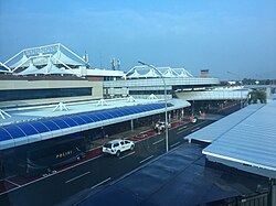 Sultan Mahmud Badaruddin II International Airport is the most important airport of the province, serving the capital, Palembang
 -
 Palembang Light Rail Transit takes passengers from the airport to Palembang
 -
 A local bus in South Sumatra
 -
 An intercity train bound for Palembang at Lubuklinggau railway station


In addition, there are several railway lines in the province. Kertapati railway station in Palembang is the largest station in the province. It serves trains to and from Lubuklinggau and Bandar Lampung in Lampung province, and also smaller towns such as Baturaja, Lahat and Prabumulih. Currently, the railway only terminates in Lubuklinggau, but there is a plan to construct a railway to Bengkulu, which would allow to boost passengers movement and economic growth.[38] Moreover, a railway from Palembang to Betung in Jambi is also in the planning stage, which would be connected further to Riau and North Sumatra.[39] Overall, these projects would form the backbone of the Trans-Sumatra Railway.[40]
The Palembang Light Rail Transit started operating in August 2018. It is one of its first kind in Indonesia and it is used to carry passengers from the Sultan Mahmud Badaruddin II International Airport to the Palembang city center.[41]
Currently, the only toll road in South Sumatra is the 22 km Palembang-Indralaya toll road. However, in the masterplan of the Trans-Sumatra Toll Road, the province would be connected by toll roads to other provinces like Bengkulu, Jambi and Lampung. Construction of the Bakauheni-Bandar Lampung-Palembang toll-road is predicted to be finished by late 2019,[42] while the Palembang-Betung-Jambi toll-road and the Lubuklinggau-Bengkulu toll-road is still in planning stage.[43]
Economy
[edit]- Agriculture (13.2%)
- Manufacturing (17.5%)
- Other Industrial (10.9%)
- Mining and Quarrying (27.6%)
- Service (30.8%)

There are five sectors that support economic growth in South Sumatra, such as the processing industry, mining, agriculture, construction, and large and retail trade, and the development of the Tanjung Api-Api Special Economic Zones (KEK), South Sumatra's economic growth is also supported by tourism.
The coal deposits of South Sumatra amount to 22.24 billion tons or 48.45 percent of the total national reserves. The province also has 4.18 trillion standard cubic feet of natural gas and 757.4 standard cubic feet of natural oil.[45]
However, the agricultural sector is still the cornerstone of employment in South Sumatra compared to other sectors with absorption reaching 1.9 million people. This figure is in accordance with the potential of the area which has an area of around 774 thousand hectares of agriculture. The potential of agricultural resources in South Sumatra is quite prominent with annual production of rice reaching 4.2 million tons, corn production reaching 289 thousand tons, soybeans production reaching 16 thousand tons, palm oil production reaching 2.718 million tons, coffee (dry beans) production reaching 135.2 thousand tons, coconut production reaching 65 thousand tons. In addition to the agricultural sector, the other two sectors also absorb labor, namely the large and retail trade sector, car and motorcycle repair and the processing industry. In the trade sector there are 688,000 workers, and the processing industry reaches 279,300 people.[46]

The economy of South Sumatra in the second quarter of 2017 continued to show improvement compared to previous quarters. The realization of economic growth in South Sumatra in the second quarter of 2017 was 5.24% (YoY), higher than the first quarter of 2017 of 5.13% (YoY). From the demand side, the component of foreign exports is still the main pillar of economic growth. This was mainly supported by improvements in the prices of superior commodities in South Sumatra, namely rubber and coal. In addition, export performance was driven by improvements in the economic conditions of the main destination countries for South Sumatra's exports, including the United States, China and Europe. On the other hand, an increase in export performance has no impact on increasing household consumption. The slowdown in household consumption is estimated to be caused by the consumption pattern of people experiencing a shift. The community began to reduce tertiary needs reflected in the decline in the consumption index of durable goods. Meanwhile, in the second quarter of 2017 government consumption declined due to some government projects still in the auction stage.[47]
Cuisine
[edit]The South Sumatran cuisine or also known as the Palembang cuisine is the cuisine of the city of Palembang and the surrounding area in South Sumatra. It is the second most well-known cuisine from Sumatra after Padang. Palembang cuisine primarily uses freshwater fish and prawns as key ingredients due to the paramount role of the Musi River for the area. Popular freshwater fish includes patin (Pangasius), baung (Hemibagrus), lais (Kryptopterus cryptopterus), lele (catfish), gabus (snakehead), mas (carp) and gurame (gourami). Historically, Palembang waters were teeming with belido (giant featherback), and it has become the city's official animal mascot. It is valued for its succulent flavour and soft texture. However, due to overfishing, today the belido fish are scarce and probably already extinct in Musi river area.[48] Because of its location that is not far from the sea, seafood such as shrimp, tenggiri (wahoo), kakap merah (red snapper) and Spanish mackerel are also popular in Palembang.[citation needed] Besides freshwater fish dishes, there are many variations of dishes, snacks, drinks, and sweets in Palembang cuisine.
- Cuisine of South Sumatra
-
 Pempek (fish cake) Kapal Selam and Kriting, simmered with Kuah Cuko
 -
 Laksan Palembang, fish cake similar to pempek served in rich coconut milk-based soup, and sprinkled with crispy fried shallot
 -
 A bowl of Tekwan
 -
 Mie celor Palembang


Spices are also generally included although not as liberally as its same-island counterpart. Palembang cuisine is noted by its preference for the sour and sweet flavour,[49] as evidenced in pindang fish soup, strong-smelling tempoyak-based dish made from fermented durian, and also kuah cuko spicy sweet vinegar sauce of pempek fishcake. Those dishes are popular fare and often associated with the city.[50]
Malay, Javanese, Indian, and Chinese culture has influenced Palembang's culinary scene. Pempek, tekwan and mie celor are the example of Chinese cuisine influence on Palembang. Pempek is basically fishcake made from deboned fish flesh and tapioca flour, which was a local adaptation of East Asian surimi fishcake making. Like most of noodle dishes of Indonesia, mie celor can trace its origin back to Chinese influences. It was popularly believed that Palembang preference of sweet flavour was due to Javanese influences that favoured palm sugar. Indeed, Palembang absorbs many Javanese elements, including language and cuisine. For example, both Javanese and Palembang Malay dialects refer fish as iwak, and cooking method employing banana leaf package as brengkes or brengkesan.[49] Martabak Palembang and nasi minyak which uses ghee, on the other hand, demonstrate Indian cuisine influence in the city.
Sports
[edit]
South Sumatra, especially the city of Palembang is notable as the host city 2018 Asian Games along with Jakarta, the first Asian Games hold officially by two cities and the fourth host city of Asian Games in Southeast Asia after Bangkok in 1998.[51] Palembang is also the main host of 2011 Southeast Asian Games and hosted two matches of 2007 AFC Asian Cup.[52][53][54] Sport facilities have been built across the city since 1971 to host Pekan Olahraga Mahasiswa (POM) IX, although the city's main sport complex, Jakabaring Sport City started its construction in 1998 and expanded later in 2010.[55][56] In order to keep the sport complex in frequent use, several plans have been raised by the government to encourage more sporting events into the city, including the purchase of an association football club, Persijatim Solo F.C in 2004 which then renamed to Sriwijaya F.C.[57] Palembang also planned to build a race track inside the complex to host a MotoGP race in the city.[58]
Football is regarded as the most popular sport in South Sumatra. Sriwijaya F.C is the only active professional football club in South Sumatra and is widely followed across the province, especially in its home city Palembang. During its home matches, the stadium often flooded with fans wearing yellow shirts on south stands, green shirts on north stands, and black shirts on east stands, representing three main ultras of the club. Badminton, basketball, volleyball and futsal also get wide attention in the city. Besides Sriwijaya F.C., notable sport teams in Palembang are BSB Hangtuah (basketball) and Palembang Bank Sumsel Babel (volleyball). Indonesian badminton players Mohammad Ahsan and Debby Susanto are also from Palembang.[59][60]
See also
[edit]References
[edit]- ^ a b c d Badan Pusat Statistik, Jakarta, 28 February 2025, Provinsi Sumatera Selatan Dalam Angka 2025 (Katalog-BPS 1102001.16)
- ^ Indonesia's Population: Ethnicity and Religion in a Changing Political Landscape. Institute of Southeast Asian Studies. 2003.
- ^ "Sensus Penduduk 2010 Provinsi Sumatera Selatan Menurut Agama Yang dianut" [2010 South Sumatra Census]. sp2010.bps.go.id (in Indonesian). 2010.
- ^ Badan Pusat Statistik (2023). "Produk Domestik Regional Bruto (Milyar Rupiah), 2020–2022" (in Indonesian). Jakarta: Badan Pusat Statistik.
- ^ Badan Pembangunan Nasional (2023). "Capaian Indikator Utama Pembangunan" (in Indonesian). Jakarta: Badan Pembangunan Nasional.
- ^ "Indeks Pembangunan Manusia 2024" (in Indonesian). Statistics Indonesia. 2024. Retrieved 15 November 2024.
- ^ "Law No. 9 of 2023 on South Sumatra Province". bpk.go.id (in Indonesian).
- ^ a b Badan Pusat Statistik, Jakarta, 2021.
- ^ "Prehistoric mother and child burial unearthed in Sumatran cave". archaeologynewsnetwork.blogspot.com.
- ^ "Prehistoric artifacts found in S. Sumatra".
- ^ George Cœdès, Louis-Charles Damais, (1992), Sriwijaya: history, religion & language of an early Malay polity : collected studies, MBRAS, ISBN 983-99614-1-1.
- ^ P. J. Suwarno, (1993), Pancasila budaya bangsa Indonesia:Penelitian Pancasila dengan pendekatan historis, filosofis & sosio-yuridis kenegaraan, Kanisius, ISBN 979-413-967-X.
- ^ Marwati Djoened Poesponegoro, Nugroho Notosusanto, (1993), Sejarah Nasional Indonesia II (6 Seri), Edisi Pemuktahiran, PT Balai Pustaka, ISBN 979-407-408-X
- ^ a b c d Munoz, Paul Michel (2006). Early Kingdoms of the Indonesian Archipelago and the Malay Peninsula. Singapore: Editions Didier Millet. p. 171. ISBN 9789814155670.
- ^ Collins 2005, p. 8.
- ^ Susanti, Dini; Rohman, Yusuf Ali (August 2011). PELAJARAN IPS-SEJARAH BILINGUAL:Untuk SMP/MTs. Kelas VII. Bandung: CV. YRAMA WIDYA. p. 86. ISBN 978-979-543-708-6.
- ^ Wade, Geoffrey (2009). "An Early Age of Commerce in Southeast Asia, 900–1300 CE" (PDF). www.eastwestcenter.org. p. 252. Retrieved 16 January 2013.
- ^ a b Sucipto 2009, p. 30.
- ^ Munoz 2006, p. 150.
- ^ Early kingdoms of the Indonesian archipelago and the Malay Peninsula by Paul Michel Munoz p.161
- ^ Cengage Advantage Books: The Earth and Its Peoples by Richard Bulliet, Pamela Crossley, Daniel Headrick, Steven Hirsch, Lyman Johnson p.182
- ^ Sastri K. A. N., (1935). The Cholas. University of Madras.
- ^ Sucipto 2009, p. 29.
- ^ Friedrich Hirth and W.W. Rockhill Chao Jukua, His Work on the Chinese and Arab Trade in the Twelfth and Thirteenth centuries, entitled Chu-fan-chi Archived 2011-07-21 at the Wayback Machine St Petersburg, 1911.
- ^ Cœdès, George (1918). "Le Royaume de Çriwijaya". Bulletin de l'École Française d'Extrême-Orient. 18 (6): 1–36.
- ^ Ricklefs, M.C. A history of modern Indonesia since c. 1300. p. 139.
- ^ Schellinger, Paul E.; Salkin, Robert M., eds. (1996). Asia and Oceania: International Dictionary of Historic Places. New York: Routledge. p. 663. ISBN 1-884964-04-4.
- ^ "The Battle for Palembang". Forgotten Campaign: The Dutch East Indies Campaign 1941–1942. Retrieved 22 March 2019.
- ^ Kita, Bunga Mayang Tiuh (2012). "Irsan Singo Mataram: Sejarah Sumatera Selatan". irsansingomataram.blogspot.com.
- ^ "Sembilang National Park - South Sumatra Swamp Forest". www.gili-lombok.com. 2020. Retrieved 2020-01-19.
- ^ Pungky Nanda Pratama. "In Search of the Sumatran Tiger". Wild Ark. Retrieved 6 September 2023.
- ^ Badan Pusat Statistik, Jakarta, 2011.
- ^ Jumlah Penduduk Menurut Kabupaten/Kota (Jiwa), 2019-2021
- ^ Jumlah Penduduk menurut Wilayah dan Jenis Kelamin, Provinsi SUMATERA SELATAN, Tahun 2020
- ^ Indeks-Pembangunan-Manusia-2014
- ^ Law No. 7/2017 (UU No. 7 Tahun 2017) as amended by Government Regulation in Lieu of Law No. 1/2022 and Regulation of General Elections Commission No. 6/2023.
- ^ "Jumlah Penduduk Menurut Agama" (in Indonesian). Ministry of Religious Affairs. 31 August 2022. Retrieved 29 October 2023.
- ^ Jordan, Ray. "Jokowi Janji Rampungkan Bandara dan Jalur Kereta di Bengkulu". detikfinance. Jakarta: detikcom. Retrieved 2019-03-17.
- ^ Saputra, Dodi. Abdullah, Syarif (ed.). "Pemprov: pembangunan rel KA Jambi tetap berjalan - ANTARA News Jambi". Antara News. Jambi: ANTARA News Agency. Retrieved 2019-03-17.
- ^ Idris, Muhammad. "Sumatera Punya 1.276 Km Rel KA, Tapi Putus-Putus". detikfinance. Jakarta: detikcom. Retrieved 2019-03-17.
- ^ Siregar, Raja Adil. "LRT Palembang Mulai Beroperasi Hari Ini". detikfinance. Palembang: detikcom. Retrieved 2019-03-17.
- ^ Siregar, Raja Adil. "Tol Lampung-Palembang Baru Bisa Rampung Medio 2019". detikfinance. Jakarta: detikcom. Retrieved 2019-03-17.
- ^ "Hutama Karya akan Garap Proyek Tol Betung-Jambi". Republika Online. 2018-06-06. Retrieved 2019-03-17.
- ^ "Provinsi Sumatera Selatan Dalam Angka 2023". Statistics Indonesia. Retrieved 22 September 2023.
- ^ Indian investor to build railroad track in S Sumatra
- ^ "BPS: Mayoritas Warga Sumsel Bekerja di Sektor Pertanian". Warta Ekonomi. 2018-05-19. Retrieved 2019-03-17.
- ^ "Kajian Ekonomi dan Keuangan Regional Provinsi Sumatera Selatan Agustus 2017 - Bank Sentral Republik Indonesia". www.bi.go.id. Retrieved 2019-03-17.
- ^ Inge, Nefri. "Tugu Ikan Belido di Palembang Bakal Saingi Merlion Singapura". liputan6.com (in Indonesian). Palembang: Liputan6.com. Retrieved 2018-07-18.
- ^ a b "Manis Asam Brengkes Patin Tempoyak". detikfood (in Indonesian). Jakarta: detikcom. Retrieved 2018-07-17.
- ^ Bell, Loren; Butler, Stuart; Holden, Trent; Kaminski, Anna; Skolnick, Adam; Stewart, Iain; Berkmoes, Ryan Ver; McNaughtan, Hugh (2016). Lonely Planet Indonesia. Lonely Planet. ISBN 9781760341619.
- ^ Andriawan, Sheshar (21 September 2014). "Jakarta dan Palembang Resmi Menjadi Tuan Rumah Asian Games 2018". beritasatu.com (in Indonesian). Jakarta: BeritaSatu.com. Retrieved 2019-03-17.
- ^ Burhan, Ruslan, ed. (11 July 2009). "Kota Palembang Menjadi Tuan Rumah SEA Games 2011". Antara News. Palembang: antaranews.com. Retrieved 2019-03-17.
- ^ lou, ed. (21 October 2009). "Palembang Siap Gelar Pembukaan SEA Games 2011". KOMPAS.com (in Indonesian). Jakarta: Kompas Cyber Media. Retrieved 2019-03-17.
- ^ "Final 3-4 Piala Asia di Palembang". sepakbola. Palembang: detikcom. Retrieved 2019-03-17.
- ^ Sketsa, Diposting oleh Palembang Dalam. "Pekan Olah Raga Mahasiswa IX Palembang Tahun 1971". Archived from the original on 2018-05-07. Retrieved 2019-03-17.
- ^ Wahyudi, Rendra (2017-04-27). "Stadion Jakabaring". sumber.com (in Indonesian). Retrieved 2019-03-17.
- ^ "Mengapa Klub-Klub Indonesia Mudah Pindah dan Berganti Nama?". FourFourTwo (in Indonesian). 2016-04-13. Retrieved 2018-05-06.
- ^ Bogi Triyadi. "Palembang Optimistis Jadi Tuan Rumah MotoGP 2019". Palembang: Liputan6.com. Retrieved 2018-05-06.
- ^ "Mohammad Ahsan". WowKeren. Retrieved 2018-05-06.
- ^ "Profil Debby Susanto". www.viva.co.id (in Indonesian). PT VIVA MEDIA BARU- VIVA. 2017-10-05. Retrieved 2018-12-15.
External links
[edit]Regencies and cities of South Sumatra | ||
|---|---|---|
Capital: Palembang | ||
| Regencies | ||
| Cities | ||
| Sumatra |  | |
|---|---|---|
| Java | ||
| Lesser Sunda Islands | ||
| Kalimantan | ||
| Sulawesi | ||
| Maluku Islands | ||
| Western New Guinea | ||
| Former provinces |
| |
| International | |
|---|---|
| National | |
| Geographic | |
| Other | |
South Sumatra
View on GrokipediaThe province covers an area of 86,772 square kilometers and had a population of 8,837,301 as of 2024.[2][3] Its capital and largest city is Palembang, situated on the banks of the Musi River. Geographically, South Sumatra features the western extension of the Barisan Mountains along its border, transitioning to flat, fertile, and often marshy plains in the east, supporting extensive agriculture and resource extraction.[4]
Economically, the province is prominent for its natural resource sectors, including coal mining, petroleum production, and plantations of rubber and palm oil, which form the backbone of its industries alongside manufacturing.[5] Historically, the region around Palembang served as the core of the Srivijaya kingdom, a major 7th-century Buddhist maritime power that influenced trade across Southeast Asia.[6] South Sumatra's development has been marked by infrastructure growth, such as transportation links via the Musi River and modern rail, though it faces challenges from heavy reliance on fossil fuels amid global energy transitions.[7]
History
Prehistoric and Early Settlements
Archaeological investigations reveal evidence of human habitation in South Sumatra dating to the early Holocene, with the western gallery of Gua Harimau cave yielding artifacts and faunal remains associated with occupation around 10,000 years ago, marking the earliest radiometrically dated cave site in the region.[8] This site, located near Baturaja in the karst highlands, indicates foraging activities in a tropical environment, supported by stone tools and animal bones suggesting adaptation to local riverine and forested ecosystems. Subsequent layers at Harimau also produced bronze and iron artifacts, signaling the onset of the Metal Age in southern Sumatra by the late prehistoric period, with metallurgy likely influenced by trade networks extending from mainland Southeast Asia.[9] Megalithic structures and associated artifacts from the Bronze Age are prominent in upland areas, as seen at the Kotaraya Lembak site in Musi Rawas Regency, where excavations uncovered dolmens, stone cists, and pottery fragments indicative of ritual and burial practices around 2,000–1,000 BCE.[10] Similarly, the Pasemah highlands feature extensive complexes of menhirs, terraces, and cup-marked boulders, dated to the mid- to late Bronze Age through comparative typology with regional sites, reflecting communal labor and ancestor veneration in agrarian communities transitioning from foraging to swidden cultivation.[11] These megaliths, often aligned with astronomical or topographic features, underscore a cultural continuity with Austronesian-speaking groups who introduced rice agriculture and domesticated animals. Early settlements along the southeastern coast, predating the Srivijaya era, are evidenced by over 80 sites in the Air Sugihan and Margomulyo areas of Ogan Komering Ilir, where excavations have recovered stilt-house foundations, paddle fragments, and cordage from sugar palm fibers, dated via relative stratigraphy to the Neolithic through proto-historic phases (circa 2000 BCE–500 CE).[12] The Purwo Agung site nearby further documents pre-Srivijayan coastal communities engaged in fishing and riverine trade, with ceramic sherds and shell middens pointing to sedentary villages exploiting mangrove and estuarine resources.[13] Cave art discoveries in the Bukit Bulan karst, including hand stencils and animal depictions, add to this record, though precise dating remains tentative and linked to late prehistoric hunter-gatherer mobility.[14] These findings collectively illustrate a progression from mobile Holocene foragers to more complex, resource-specialized societies by the cusp of recorded history.Srivijaya Empire Influence
The Srivijaya Empire, a maritime thalassocracy centered in Palembang in present-day South Sumatra, emerged in the late 7th century CE as a dominant power in Southeast Asian trade networks. Archaeological evidence from the Palembang region, including brick temple foundations and Indian-influenced artifacts, indicates its role as the empire's primary urban and administrative hub.[15] The Kedukan Bukit inscription, unearthed in Palembang and dated to 16 June 682 CE (604 Saka), describes a successful naval expedition upstream along the Musi River led by Dapunta Hyang, interpreted as an early ruler consolidating control over South Sumatran riverine territories.[16] This influence extended to religious and environmental practices, as seen in the Talang Tuwo inscription from 684 CE (606 Saka), found at Bukit Seguntang near Palembang, which records King Sri Jayanasa's dedication of a sacred Buddhist park (śrīkṣetra) emphasizing sustainable landscape management and worship of the Buddha.[17] Srivijaya's control facilitated upstream-downstream economic integration in South Sumatra, with Palembang serving as a nexus for collecting goods like forest products and agricultural yields from interior peneplain settlements for export via coastal routes.[18] The empire promoted Mahayana Buddhism, establishing South Sumatra as a pilgrimage and scholarly center, evidenced by temple remains and artifacts linking to broader Indian cultural transmissions.[19] Srivijaya's hegemony over the Strait of Malacca trade routes bolstered South Sumatra's prosperity through tolls and alliances, but invasions by the Chola dynasty in 1025 CE disrupted naval dominance, initiating fragmentation.[20] By the 13th century, rising powers like the Kediri kingdom and internal strife eroded central authority, though Srivijayan cultural and trade legacies persisted in South Sumatran polities.[21]Palembang Sultanate Era
The Palembang Sultanate, formally known as Kesultanan Palembang Darussalam, was established in 1659 by Susuhunan Abdurrahman following the fragmentation of earlier regional powers after the decline of the Srivijaya Empire and Majapahit influences.[22] This Islamic sultanate centered on Palembang along the Musi River, exerting control over territories in present-day South Sumatra, including upstream regions like Musi Rawas and parts of the Ogan and Komering river basins.[4] The sultanate's authority relied on a feudal structure with local chieftains (panglimas) managing riverine domains, fostering a Malay-dominated society influenced by Islam, which had spread through trade networks since the 13th century.[22] Economically, the sultanate thrived on the Musi River's navigability, enabling exports of pepper from extensive plantations, gold from upstream mines, and tin from Bangka Island, where unregulated mining and trade with British merchants yielded significant revenues despite Dutch restrictions.[23] Pepper production involved forced cultivation systems, with the Dutch East India Company (VOC) securing a trade monopoly in 1642 after establishing a factory in 1617, though smuggling persisted. Chinese merchants dominated local commerce, intermarrying with elites and contributing to urban growth, while the sultanate's ports facilitated exchanges with Malay Peninsula traders and Southeast Asian networks.[24] Governance under sultans like Abdurrahman (1659–1706) emphasized Islamic legitimacy, with the construction of the Masjid Agung in 1748 under later rulers symbolizing religious consolidation.[25] Successive sultans navigated European pressures; Sultan Muhammad Bahauddin (1776–1803) fortified Kuto Besak palace, but tensions escalated under Mahmud Badaruddin II (1804–1823), who resisted Dutch encroachments amid post-Napoleonic realignments.[26] The sultanate's decline accelerated during the early 19th century. British forces under Thomas Stamford Raffles occupied Palembang in 1811–1812, extracting concessions before withdrawal, only for the Dutch to reassert claims post-1816 Anglo-Dutch Treaty.[27] Sultan Mahmud Badaruddin II's defiance, including attacks on Dutch shipping in 1821, prompted a full-scale invasion; Dutch troops captured Palembang on August 7, 1821, exiling the sultan and abolishing the sultanate on October 7, 1823, after mopping up resistance in interior strongholds.[27] [28] This conquest integrated South Sumatran territories into the Dutch East Indies, shifting control from indigenous rulers to colonial residency, fundamentally altering local power dynamics and resource extraction.[27]Colonial Period and Japanese Occupation
The Dutch East India Company established a trading post in Palembang in 1659 to control the lucrative pepper trade from Sumatra, constructing fortifications to secure their commercial interests.[29] Ongoing tensions with the Palembang Sultanate escalated into military confrontations, including British intervention during the Napoleonic Wars, but Dutch forces reasserted dominance.[30] In 1821, Dutch expeditionary forces under Lieutenant-General Hendrik Merkus de Kock launched a decisive campaign against Palembang, capturing the capital after fierce resistance from Sultan Mahmud Badaruddin II, who had challenged colonial trade restrictions and piracy accusations.[31][27] The sultan was deposed and exiled, abolishing the sultanate's autonomy and imposing direct Dutch administration over the region.[27] This conquest integrated Palembang and surrounding territories into the Dutch East Indies by 1823, facilitating bureaucratic centralization, land tenure reforms, and economic shifts toward export-oriented agriculture such as pepper and later rubber plantations.[30][27] Under prolonged Dutch rule, South Sumatra's residency—encompassing Palembang and adjacent areas—experienced infrastructure development alongside exploitative policies like the Cultivation System (1830–1870), which mandated peasant labor for cash crops, yielding significant revenues but causing local hardships through coercive quotas and market distortions.[30] Japanese forces invaded Sumatra in February 1942 as part of their Dutch East Indies campaign, parachuting troops to seize Palembang's strategic oil refineries on February 14–17 amid Allied demolitions that limited immediate gains.[32][33] Palembang became a pivotal Japanese base for southern Sumatra operations, with the occupation enforcing resource mobilization for the war effort, including oil extraction and forced labor on projects like railways and defenses.[33] European and Eurasian civilians faced internment in camps near Palembang, enduring malnutrition, disease, and separations under military administration.[34] The Japanese regime, lasting until their surrender in August 1945, nominally fostered Indonesian self-governance through organizations like PETA (Indonesian Army auxiliaries) but prioritized imperial demands, sparking rural unrest and food shortages across Sumatra that exacerbated wartime suffering.[35][36] This period undermined Dutch prestige without delivering independence, priming local elites for post-war revolutionary activities.[36]Independence and Provincial Formation
Following the Japanese surrender in World War II, Indonesia's independence was proclaimed on 17 August 1945 by Sukarno and Mohammad Hatta in Jakarta, prompting local revolutionary committees in Palembang and surrounding areas of South Sumatra to establish republican governance autonomously, integrating the region into the nascent Republic's administrative framework under Sumatra Province.[37] Dutch forces, seeking to reassert colonial authority, encountered armed resistance, including the intense urban combat known as the "Battle of Five Days and Five Nights" in Palembang from 1 to 5 January 1947, where Indonesian irregulars, student soldiers, and civilians repelled Dutch advances, inflicting significant casualties and delaying reoccupation until later that month.[38] As part of the Netherlands' strategy during the Indonesian National Revolution, the State of South Sumatra was created on 30 August 1948 as a federated entity within the United States of Indonesia, covering roughly the southern quarter of modern South Sumatra's territory and led by figures aligned with Dutch interests.[28] This structure aimed to fragment republican unity but lacked broad local support amid ongoing guerrilla warfare.[39] The Round Table Conference agreements culminated in the Dutch transfer of sovereignty on 27 December 1949, incorporating the State of South Sumatra into the unitary Republic of Indonesia and prompting its dissolution on 24 March 1950.[28] In September 1950, as part of the reorganization of Sumatra, the Province of South Sumatra was formally established, initially encompassing a larger area including present-day Bengkulu and parts of Lampung, with Palembang designated as the capital; subsequent divisions in 1967 and 2000 refined its boundaries to the current configuration.[40][41]Geography
Physical Landscape and Topography
South Sumatra's topography transitions from rugged, volcanic highlands in the west to low-lying plains and wetlands in the east. The western margin consists of the Plio-Pleistocene Barisan Mountains, a range of metamorphic and igneous formations surmounted by volcanic cones.[42] This region features steep slopes and elevations exceeding 3,000 meters, with the highest point being Gunung Dempo, a stratovolcano reaching 3,173 meters above sea level on the border with Bengkulu province.[43] [44] Prominent peaks in the Barisan range within the province include Gunung Patah at 2,850 meters and Gunung Pasu at 2,078 meters, contributing to a landscape of forested volcanic uplands and deep valleys dissected by river headwaters.[44] Central South Sumatra exhibits undulating hills and plateaus formed by erosion of older sedimentary and igneous rocks, with elevations generally between 100 and 500 meters.[42] The eastern and coastal areas comprise extensive alluvial plains, peat swamps, and tidal marshes, averaging around 115 meters in elevation province-wide but dropping to near sea level in the lowlands.[45] These flat terrains, influenced by sediment deposition from major rivers originating in the Barisan Mountains, support broad floodplains prone to seasonal inundation and mangrove ecosystems along the coast.[42] The overall relief reflects tectonic uplift in the west contrasting with subsidence and sedimentation in the east, shaping a diverse physiographic profile.[42]Hydrology and Natural Resources
The hydrology of South Sumatra is dominated by the Musi River basin, which covers approximately 96% of the province's area and extends into parts of neighboring provinces. The Musi River, the longest in the province at 720–750 km, originates in the Barisan Mountains and flows eastward through Palembang before emptying into the Bangka Strait. Its basin is subdivided into sub-basins corresponding to major tributaries, including the Komering, Ogan, and Lematang rivers, which facilitate drainage across the lowland plains and contribute to seasonal flooding.[46][47] South Sumatra features diverse wetland ecosystems integral to its hydrological system, comprising tidal swamps, freshwater swamps, peatlands, and riverine floodplains, with the Musi River serving as the primary waterway. These wetlands support water storage and filtration but face degradation from sedimentation and pollution; for instance, the Musi River exhibits light pollution levels, with total suspended solids (TSS) and dissolved oxygen (DO) occasionally exceeding thresholds due to urban and agricultural runoff. Lakes are less prominent compared to river and swamp systems, though smaller bodies contribute to local groundwater recharge in upland areas.[48][49] Natural resources in South Sumatra are abundant in fossil fuels, with the province's Tertiary half-graben basins yielding significant petroleum and natural gas production onshore. Coal reserves are substantial, accounting for about 31.59% of the provincial energy mix as of 2024, alongside natural gas at 22.68% and petroleum derivatives. Mineral deposits include bauxite and other metals, though extraction focuses primarily on energy commodities; forestry resources, such as timber from peat swamp forests, have historically supported the economy but are constrained by environmental regulations. Agricultural lands yield crops like rubber and coffee, leveraging fertile alluvial soils from river deposits, though these are secondary to extractive industries in resource valuation.[50][51][52]Climate and Biodiversity
South Sumatra exhibits a tropical monsoon climate, with consistently high temperatures and humidity throughout the year. In Palembang, the provincial capital, the average annual temperature stands at 26.3 °C, with daily highs typically ranging from 30-32 °C and lows around 24-25 °C, showing little seasonal fluctuation.[53][54] Annual precipitation averages 2,465 mm, predominantly during the wet season from October to April, when monthly rainfall can exceed 300 mm and December sees the highest number of rainy days at approximately 16.9.[53][55] The drier period spans May to September, influenced by Australian continental air masses, though isolated downpours remain common due to the region's equatorial position.[56] Recent analyses indicate an upward trend in annual average temperature by 0.04 °C per year and rainfall by 6.83 mm per year from 1990 to 2020, consistent with observed warming in Sumatra's lowland areas.[57] The province's ecosystems support substantial biodiversity, particularly in lowland rainforests, peat swamps, and mangrove forests along the eastern coast and Musi River basin. Bukit Barisan Selatan National Park, partially within South Sumatra, encompasses the island's largest intact lowland rainforest expanse at over 3,500 km² and functions as a key biodiversity hotspot.[58] It harbors critically endangered species including the Sumatran tiger (Panthera tigris sumatrae), Sumatran elephant (Elephas maximus sumatranus) with roughly 500 individuals comprising 25% of the global population, Sunda clouded leopard (Neofelis diardi), and marbled cat (Pardofelis marmorata).[59][60] Avian diversity exceeds 300 species, featuring vulnerable wetland birds like the lesser adjutant (Leptoptilus javanicus) and white-winged duck (Asarcornis scutulata), while flora includes endemic orchids and the parasitic Rafflesia arnoldii.[61] Evidence of Sumatran rhinoceros (Dicerorhinus sumatrensis) persists in the park, though populations are minimal and unconfirmed by direct sightings since 2017.[63] Human activities pose acute threats to this biodiversity through habitat loss. Deforestation rates in Sumatra, including South Sumatra, surged with palm oil expansion, recording a 3.7-fold increase in industrial palm oil-linked forest clearance from 2020 to 2022, fragmenting habitats and elevating extinction risks for large mammals reliant on contiguous forests.[64] Coal mining in the province's interior further exacerbates degradation, converting biodiverse areas into open pits and reducing carbon-storing peatlands.[65] These drivers have contributed to broader Sumatran biodiversity decline, with primary forest loss averaging 0.84 million hectares annually from 2000-2012, disproportionately affecting endemics.[66] Conservation initiatives, such as UNDP-supported tiger recovery programs, emphasize protected area enforcement and habitat restoration, yet enforcement gaps and economic pressures from agribusiness continue to undermine efficacy.[67]Government and Administration
Administrative Divisions
South Sumatra province is subdivided into 13 regencies (kabupaten) and 4 independent cities (kota), which constitute the second-tier administrative units under the provincial government.[68] These divisions handle local governance, including public services, infrastructure, and development planning, with Palembang serving as the provincial capital and largest city.[69] Each regency and city is further divided into districts (kecamatan), totaling 241 as of recent counts, and subsequently into villages (desa) or urban neighborhoods (kelurahan).[68] The regencies and cities, along with their administrative centers, are as follows:| No. | Regency/City | Administrative Center |
|---|---|---|
| 1 | Banyuasin Regency | Pangkalan Balai |
| 2 | Empat Lawang Regency | Tebing Tinggi |
| 3 | Lahat Regency | Lahat |
| 4 | Muara Enim Regency | Muara Enim |
| 5 | Musi Banyuasin Regency | Sekayu |
| 6 | Musi Rawas Regency | Lubuk Pandan |
| 7 | Ogan Ilir Regency | Indralaya |
| 8 | Ogan Komering Ilir Regency | Kayu Agung |
| 9 | Ogan Komering Ulu Regency | Baturaja |
| 10 | Ogan Komering Ulu Selatan Regency | Talang Padang |
| 11 | Ogan Komering Ulu Timur Regency | Martapura |
| 12 | Penukal Abab Lematang Ilir Regency | Talang Ubi |
| 13 | Musi Rawas Utara Regency | Rupit |
| 14 | Lubuklinggau City | Lubuklinggau |
| 15 | Pagar Alam City | Pagar Alam |
| 16 | Palembang City | Palembang |
| 17 | Prabumulih City | Prabumulih |
Governance Structure
The governance structure of South Sumatra Province operates under Indonesia's decentralized system as defined by Law No. 23 of 2014 on Local Government, which grants provinces executive, legislative, and administrative autonomy subject to national laws and fiscal transfers. Executive authority is centralized in the Governor, the province's highest official, who directs policy execution, resource allocation, inter-regional coordination, and development planning. Elected via direct suffrage for a five-year term (renewable once) under Law No. 10 of 2016 on Regional Head Elections, the Governor collaborates with a Deputy Governor and oversees the Regional Secretariat (Sekretariat Daerah), which provides administrative, legal, and planning support through bureaus for general administration, autonomy and cooperation, and organizational affairs. This secretariat, along with specialized Regional Device Organizations (such as the Transportation Office and Education Office), forms the core bureaucracy, with its composition and functions stipulated in Governor Regulation No. 42 of 2020.[72] Legislative powers are exercised by the Provincial Regional People's Representative Council (DPRD Provinsi Sumatera Selatan), comprising 75 members elected proportionally in multi-member constituencies during synchronized regional elections every five years, as finalized after the February 2024 polls. The council's leadership includes one Chairman and three Deputy Chairmen, drawn from parties securing the largest seat shares, supported by commissions addressing sectoral issues like economy, public welfare, and legal oversight. The DPRD enacts provincial regulations (Perda), approves the annual regional budget (APBD), and supervises executive performance through inquiries, recommendations, and interpellation rights, ensuring checks on gubernatorial actions while aligning with national priorities.[73] Inter-branch coordination occurs via joint forums for budget deliberations and policy reviews, with the Governor holding veto power over DPRD legislation subject to gubernatorial or presidential review. Provincial administration interfaces with 17 regencies and 4 autonomous cities through coordination bodies, emphasizing fiscal discipline and service delivery in areas like infrastructure and health, though implementation challenges persist due to varying local capacities. Judicial functions fall under national courts, including the Palembang High Court, without provincial-level adjudication.Governors and Political Leadership
South Sumatra's governorship has evolved from appointed positions during the early post-independence period to direct elections following Indonesia's 1999 democratic reforms and the 2004 regional autonomy law, which empowered provinces to elect governors for five-year terms, renewable once.[74] Early governors were often military or administrative figures amid the revolutionary struggles, transitioning to civilian leaders under New Order authoritarianism, where appointments by the central government favored loyalty to President Suharto's Golkar party. Post-1998, competitive multi-party elections have dominated, with coalitions involving major parties like Golkar, PDI-P, and NasDem influencing outcomes, though local primordial ties and patronage networks remain influential in voter mobilization.[75][76] The following table lists governors from provincial formation in 1950, with terms reflecting official records; pre-1950 figures served as regional heads during the national revolution.| No. | Name | Term | Notes/Party (if elected) |
|---|---|---|---|
| 1 | Adnan Kapau Gani | 1945–1946 | Revolutionary-era appointee.[74] |
| 2 | Mohammad Isa | 1946–1952 | Extended service amid instability.[75] |
| 3 | Winarno | 1952–1954 | Appointed under parliamentary system.[74] |
| 4 | Husen | 1954–1956 | Short term; administrative focus.[75] |
| 5 | Mochtar Prabu Mangkunegara | 1956–1960 | Oversaw early development projects.[74] |
| 6 | Abdoel Munaf | 1960–1966 | Served through Guided Democracy era.[75] |
| 7 | Hasan Basri | 1966–1968 | Transitional post-1965 events.[74] |
| 8 | Gazali | 1968–1973 | New Order appointee.[75] |
| 9 | Edwar Hasan | 1973–1978 | Focused on infrastructure.[74] |
| 10 | Burhanuddin | 1978–1983 | Golkar-aligned.[75] |
| 11 | Tjokropranolo | 1983–1988 | Continued central directives.[74] |
| 12 | Ramli Hasan Basri | 1988–1998 | Longest-serving; emphasized mining sector growth.[75] |
| 13 | Rosihan Arsyad | 1998–2003 | Transition to Reformasi; appointed initially.[74] |
| 14 | Alex Noerdin | 2003–2013 | Elected 2008; Golkar; two terms focused on Palembang's 2018 Asian Games hosting.[75] |
| 15 | Herman Deru | 2018–2023 (1st term); 2025–2030 (2nd term) | NasDem; elected 2018 and reelected post-2024 polls; prioritizes economic self-reliance and youth programs.[77][74] |
Demographics
Population Dynamics
The population of South Sumatra Province stood at 8,467,432 according to the 2020 Indonesian census conducted by Statistics Indonesia (BPS). This marked an increase from 7,450,394 recorded in the 2010 census, reflecting an average annual growth rate of approximately 1.27% over the decade, slightly above the national average of 1.25%. [79] [80] Growth during this period was driven primarily by natural increase, with fertility rates contributing alongside modest net in-migration, though decelerating from earlier decades due to declining birth rates mirroring national trends. [81] Urbanization has progressed gradually, with the proportion of urban residents rising from 34.4% in 2010 to 37.7% in 2020, concentrated in the capital Palembang and surrounding regencies like Banyuasin and Ogan Komering Ilir. [82] This shift correlates with economic pull factors in trade and services hubs, though the province maintains a low overall population density of about 78 persons per square kilometer, given its 108,156 square kilometer land area, with higher concentrations in riverine and coastal lowlands. Rural areas, particularly in upland regencies, continue to dominate demographically, supporting agriculture-based livelihoods. Projections from BPS indicate continued moderate growth, potentially reaching 9 million by 2030, tempered by aging demographics and out-migration to Java. [83] Migration patterns feature net inflows to South Sumatra, particularly from Java and other Sumatran provinces, attracted by opportunities in Palembang's urban economy and resource sectors; historical data show a preference for urban settlement among newcomers, exacerbating intra-provincial rural-to-urban flows. [84] Internal migrants often originate from rural Javanese backgrounds seeking non-farm employment, contributing to ethnic diversification, while out-migration from remote regencies to national centers like Jakarta remains limited but notable among youth. These dynamics have sustained population stability without extreme volatility, though they strain urban infrastructure in growth poles.[85]Ethnic Composition
The ethnic composition of South Sumatra reflects a blend of indigenous groups native to the island and substantial migrant populations introduced through Dutch colonial labor policies and Indonesia's post-independence transmigration program, which relocated millions from overpopulated islands like Java to outer islands including Sumatra. According to data cited from Badan Pusat Statistik (BPS), the Malay ethnic group (Melayu), encompassing subgroups such as the Palembang Malays concentrated around the provincial capital and along the Musi River, forms the largest segment at 34.37% of the population.[86] The Javanese follow closely at 27.01%, primarily descendants of transmigrants settled in rural agricultural areas since the 1930s, with numbers bolstered by ongoing internal migration for economic opportunities.[86] Indigenous non-Malay groups, classified collectively under "Suku asal Sumatera Selatan" in the 2010 census, include the Komering (distributed along the southeastern lowlands and known for wet-rice cultivation), Ogan (in the central riverine areas), Enim, Semendo, Pasemah (in the Barisan Mountains foothills), Gumai, Rawas, and smaller communities like the Serawai and Lematang. These groups, totaling several million when aggregated with Malays, maintain distinct dialects, adat customs, and subsistence practices tied to local ecology, though intermarriage and urbanization have led to cultural blending.[87] Smaller migrant ethnicities include Sundanese (from West Java), Minangkabau (from West Sumatra, often involved in trade), and Batak (from North Sumatra, active in plantation work), each comprising under 5% based on 2010 patterns extrapolated to recent estimates. Chinese Indonesians, estimated at around 2-3% province-wide but higher in Palembang (up to 10% in urban cores), trace roots to 19th-century traders and laborers, dominating retail and small-scale industry despite historical pogroms like those in 1998. Indian descendants, mainly Tamils and Gujaratis, form a tiny mercantile minority in cities. This diversity stems causally from Sumatra's role as a resource frontier, attracting labor inflows amid native population stability, with no single group achieving outright majority due to transmigration's scale—over 1 million Javanese relocated nationwide by 1980, significantly altering demographics.[87]Languages Spoken
The official language throughout South Sumatra is Indonesian (Bahasa Indonesia), which serves as the medium of instruction in schools, the language of administration, and the primary lingua franca uniting the province's diverse population.[88] The most widely spoken regional language is Palembang Malay (also called Musi or Baso Palembang), a Malayic variety mutually intelligible with standard Indonesian but featuring distinct phonology, vocabulary influenced by Javanese, and local idioms; it is primarily used by the ethnic Palembang Malays in about two-thirds of the province, centered around Palembang city and the Musi River basin, with an estimated speaker base exceeding three million.[89][90] Palembang Malay encompasses multiple subdialects, such as those of Palembang Sukabangun, Kisam, and Muara Enim, reflecting historical trade and settlement patterns along riverine communities.[90] Several other indigenous languages persist among specific ethnic groups, often in rural districts: Komering, spoken by the Komering people in Ogan Komering Ulu and related areas; Ogan, used in Ogan Komering Ilir; Semendo in parts of Muara Enim; Lematang in Ogan Komering Ilir border villages; Rawas (or Musi Rawas) in the Musi Rawas Regency; and Kayu Agung in Ogan Komering Ilir.[91][92] These languages, many of which belong to the Austronesian family and show Malayic or Lampungic affinities, are typically oral traditions with limited standardization, and efforts by the provincial Language Center (Balai Bahasa Sumatera Selatan) focus on their documentation and revitalization to counter decline from Indonesian dominance.[93] Migration has introduced additional languages, notably Javanese, spoken by descendants of transmigrants from Java in agricultural settlements across districts like Banyuasin and Musi Banyuasin, with distinct local dialects such as Makarti Jaya; Minangkabau is also present among West Sumatran migrants in urban and mining areas.[41][88] Smaller Chinese communities, concentrated in Palembang, maintain dialects like Hokkien for intragroup communication, though shifting toward Indonesian.[41] Overall, multilingualism is common, with most residents proficient in Indonesian alongside one or more local varieties, though younger generations increasingly favor Indonesian in daily use.[94]Religious Distribution
Islam constitutes the dominant religion in South Sumatra, practiced by 97.21% of the population, or 8,642,068 individuals, as recorded in official statistics for 2023.[95] This reflects the province's historical Malay-Muslim cultural core, reinforced by patterns of settlement and conversion dating back to the Srivijaya era and subsequent Islamic sultanates.[96] Christianity, encompassing Protestantism and Catholicism, accounts for 1.54% of residents, with Protestants numbering 86,346 (0.97%) and Catholics around 50,000 (0.57%) in recent counts.[95] These communities are disproportionately present in urban centers like Palembang and among transmigrant populations from eastern Indonesia, though they remain marginal overall. Buddhism, followed by 0.76% or approximately 67,000 people, is concentrated among the ethnic Chinese minority in commercial hubs.[97] Hinduism represents 0.49%, or about 43,000 adherents, often linked to Balinese or Javanese migrants, while Confucianism claims negligible numbers, under 200 individuals.[97]| Religion | Percentage | Approximate Number (2023) |
|---|---|---|
| Islam | 97.21% | 8,642,068 |
| Protestantism | 0.97% | 86,346 |
| Buddhism | 0.76% | 67,000 |
| Catholicism | 0.57% | 50,000 |
| Hinduism | 0.49% | 43,000 |
| Confucianism | <0.01% | <200 |
Economy
Primary Sectors: Mining and Energy
South Sumatra's mining sector is dominated by coal extraction, which constitutes the province's primary economic driver within primary industries. In 2023, coal production reached 105.85 million metric tons, while in 2024 it totaled 113.26 million metric tons, primarily from open-pit mines in districts such as Muara Enim, Lahat, and Musi Rawas.[99][100] These figures represent a substantial portion of Indonesia's national coal output, with South Sumatra accounting for approximately 13-15% of the country's total production in recent years.[101] Coal mining contributes significantly to the provincial gross regional domestic product (PDRB), estimated at around 32% when including associated gas, oil, lime, and iron ore activities, underscoring its role in regional economic growth.[102] The energy subsector leverages these resources for both export and domestic power generation. Natural gas and petroleum production occur in fields like the South East Sumatra Production Sharing Contract (PSC), a mature basin yielding oil since the late 19th century, though output has declined with recovery rates exceeding 98% of recoverable reserves by peak periods in the 1990s.[103] Gas production supports local infrastructure, with historical assessments indicating up to 1.9 billion cubic feet per day in the mid-2010s, much of it from operators like ConocoPhillips.[104] In the electricity mix, coal-fired plants accounted for 31.59% of generation in recent data, followed by natural gas at 22.68% and petroleum at 21.88%, highlighting reliance on fossil fuels despite renewables comprising 23.85%.[51] Exploration continues to identify untapped hydrocarbon potential in the South Sumatra Basin, with recent discoveries by operators like Pertamina Hulu Rokan (PHR) affirming ongoing viability for oil and gas development.[105] However, the sector faces challenges from fluctuating global demand and domestic policies prioritizing downstream processing, which have influenced production quotas and export dynamics.[106] Mining activities also extend to non-energy minerals like lime and iron ore, though these remain secondary to coal in scale and economic impact.[102]Agriculture and Plantations
Agriculture and plantations constitute a vital sector in South Sumatra's economy, with plantation crops such as rubber, oil palm, and coffee dominating land use and output. The province's fertile soils and tropical climate support extensive cultivation, though yields vary due to factors like smallholder practices and weather variability. In 2023, the agricultural sector, including plantations, absorbed a substantial portion of the workforce, reflecting its role in rural livelihoods despite shifts toward non-farm employment.[107] Rubber plantations cover the largest area among estate crops, spanning 883,300 hectares in 2023, representing 25% of Indonesia's total rubber land and making South Sumatra the national leader in extent. Productivity averaged 1,088 kilograms per hectare, influenced by rainfall patterns that affect tapping cycles, with smallholders comprising the majority of producers facing challenges in maintaining consistent yields.[108][109][107] Oil palm plantations have expanded significantly, driven by demand for crude palm oil, though precise provincial figures for 2023 remain aggregated within Sumatra's broader production zones; company expansions, such as SIPEF's addition of over 18,000 hectares by late 2023, underscore ongoing development in the region. This growth contributes to export revenues but raises concerns over land conversion and smallholder integration.[110][111] Coffee, primarily robusta, thrives in upland areas, with South Sumatra producing approximately 201,400 metric tons annually, accounting for about a quarter of national output from smallholder estates covering around 267,200 hectares. Production benefits from the province's position as Indonesia's top robusta hub, though vulnerability to pests and climate fluctuations impacts consistency.[112][113][114] Food crops like rice support local food security, with harvested production reaching 2.83 million tons of dry milled paddy (GKG) in 2023, rising to 2.91 million tons in 2024 amid efforts to boost yields through improved varieties and irrigation. Plantations overall bolster the sector's GDP share, though exact provincial contributions hover in the medium range relative to national agriculture, emphasizing the need for productivity enhancements to counter employment declines.[115][116]Industry and Trade
The processing and manufacturing industry constitutes a major pillar of South Sumatra's economy, contributing approximately 18.07% to the gross regional domestic product (GRDP) in recent assessments, with leading sub-sectors including food and beverages, textiles, rubber processing, and palm oil derivatives.[117][118] This sector has shown resilience amid national economic shifts, with studies highlighting its role in economic agglomeration and regional development through designated growth centers in areas like Palembang and surrounding regencies.[119][5] Production indices for manufacturing in 2023 reflected steady output in these areas, supported by raw material linkages from agriculture and mining, though challenges such as environmental impacts from expansion have prompted policy discussions on sustainability.[120][121] Trade activities, both domestic and international, further bolster the province's economic structure, with the wholesale and retail sector averaging around 17.5% contribution to GRDP over the past decade.[122] South Sumatra recorded a trade surplus of US$1.19 billion in the third quarter of 2023, marking a 41.43% year-on-year increase, driven largely by non-oil and gas exports such as processed agricultural products, rubber, and palm oil goods.[123] Export values reached US$549.94 million in February 2023 alone, with key destinations including regional partners, though global demand fluctuations have occasionally pressured processed goods shipments like frozen foodstuffs.[124][125] Infrastructure developments, including proposed export ports for palm oil products, aim to enhance trade efficiency and reduce logistical bottlenecks.[111]Economic Growth Metrics
The Gross Regional Domestic Product (GRDP) of South Sumatra grew by 5.03 percent in 2024, measured year-on-year.[126] This rate slightly trailed the 5.08 percent expansion recorded in 2023, which exceeded the national average of approximately 5.05 percent.[127] In the third quarter of 2024, quarterly growth reached 5.04 percent year-on-year, driven primarily by expansions in financial services and other sectors.[128] Post-pandemic recovery has been evident, with first-quarter 2022 GRDP expanding 5.15 percent year-on-year following contractions in prior periods.[129] Earlier, the first quarter of 2021 saw a decline of 0.41 percent year-on-year amid COVID-19 restrictions.[130] Per capita GRDP in the province reached approximately IDR 75.13 million in 2024 estimates, reflecting steady income growth aligned with resource-based economic drivers.[131]| Year | GRDP Growth Rate (%) |
|---|---|
| 2021 (Q1) | -0.41[130] |
| 2022 (Q1) | 5.15[129] |
| 2023 | 5.08[127] |
| 2024 | 5.03[126] |
Environmental Management
Resource Extraction Practices
South Sumatra's resource extraction primarily involves coal through surface mining methods, alongside conventional oil and gas drilling in onshore basins. Coal, the province's dominant extractive commodity, is predominantly extracted via open-pit surface mining using truck-and-shovel operations and bucket-wheel excavators, as practiced at major sites like the Bukit Asam mine.[132] These techniques target Tertiary coal seams in sedimentary basins, with overburden removal enabling access to deposits up to several meters thick.[133] Regulatory frameworks mandate environmental integration, including mandatory reclamation throughout mining phases under Government Regulation No. 78/2010 and Ministerial Regulation No. 26/2018, requiring operators to submit progressive reclamation plans to restore land post-extraction.[134] Non-compliance has prompted temporary suspensions of operations, as seen in 2025 when 90 mines nationwide, including Sumatran sites, were halted pending verified reclamation submissions.[134] Additionally, coal mine methane emissions must be inventoried per Ministerial Regulation No. 22/2019 to mitigate greenhouse gas releases during extraction and ventilation.[135] Oil and gas extraction employs conventional techniques, including exploratory drilling into anticlinal traps and stratigraphic reservoirs within the South Sumatra Basin's Tertiary half-graben formations, which hold synrift and marine clastic-carbonate sequences.[136] Production occurs from Miocene to Pleistocene sandstones and carbonates, often compartmentalized by intraformational seals, with recent advancements like the West Kalabau-1 well in 2025 confirming hydrocarbons via standard vertical drilling.[137] In heavy oil fields such as Bentayan, specialized methods incorporate downhole blending with low-pour-point crude as a power fluid via jet pumps to enhance flow and recovery.[138] Illegal small-scale oil extraction persists in some areas, involving rudimentary distillation and opportunistic wells, prompting provincial crackdowns that shuttered 95 such sites by August 2024 following safety incidents.[139] Overall, extraction adheres to national AMDAL environmental impact assessments, though enforcement gaps in reclamation and pollution control have drawn scrutiny from regulatory bodies.[140]Deforestation and Habitat Loss
From 2001 to 2024, South Sumatra lost 3.29 million hectares of tree cover, equivalent to 47% of the tree cover present in 2000, releasing 2.49 gigatons of CO₂ equivalent emissions.[141] In 2020, natural forest spanned 931,000 hectares, or 11% of the province's land area, with an additional 3,800 hectares of natural forest lost in 2024 alone.[141] Between 2001 and 2017, the province experienced a 36% decline in overall forest cover.[142] The principal causes stem from commercial agriculture, particularly oil palm plantation expansion, which has driven over one-third of Indonesia's deforestation in recent decades and remains a dominant factor in Sumatra.[64] Coal mining operations further accelerate loss, with active sites impacting 1.74 million hectares of Sumatran forest land through direct clearing and associated infrastructure like roads that facilitate fragmentation.[143] Illegal logging exacerbates degradation, often intertwined with land conflicts and encroachment in areas bordering plantations.[144] Habitat loss has fragmented remaining forests, reducing connectivity for wildlife and intensifying human-animal conflicts. The Sumatran tiger (Panthera tigris sumatrae), classified as critically endangered with fewer than 600 individuals island-wide, faces acute pressure in South Sumatra, where habitat encroachment has triggered fatal encounters with farmers.[145][146] The Sumatran elephant (Elephas maximus sumatranus) similarly suffers range contraction, heightening poaching vulnerabilities and crop-raiding incidents amid shrinking lowland habitats.[142] Overall biodiversity declines, including for other endemics, result from edge effects, soil erosion, and altered microclimates in degraded patches.[147] Conservation initiatives, such as habitat reconnection projects by the Zoological Society of London, target these fragmented landscapes to mitigate further isolation.[148]Pollution Control and Conservation
The Musi River Basin Water Resources Management Agency (Balai PSDA Musi) holds responsibility for water pollution control in South Sumatra's primary river system, as established by Decree No. 821/003/BPSDA M/2002 dated July 18, 2002, which assigns tasks including monitoring and mitigation of contaminants from upstream sources.[149] Water quality assessments employ the pollution index (PI) methodology to evaluate current conditions and forecast degradation, enabling targeted interventions such as regulatory enforcement against industrial discharges and community waste management.[150] Despite these frameworks, empirical surveys reveal persistent escalation in indicators like plastic debris and biochemical oxygen demand, attributed to inadequate upstream waste handling and urban runoff in Palembang, with expeditions in July 2022 documenting visible aggravation along river segments.[151][152] Conservation efforts in South Sumatra emphasize habitat preservation amid pressures from resource extraction, with protected areas demonstrating empirically lower deforestation rates—approximately 20-30% reduced compared to adjacent unprotected forests—through satellite-based analyses spanning 2000-2008.[153] The province integrates into Sumatra's broader network of over 110,000 km² of protected zones, including contributions to transboundary parks like Bukit Barisan Selatan, where enforcement curbs illegal logging and supports biodiversity corridors.[154] Community-led initiatives, such as those by the Sumatra Nature & Biodiversity Conservation foundation, promote sustainable practices linking local livelihoods to ecosystem integrity, though scalability remains constrained by funding and encroachment.[155] Wildlife-focused programs target critically endangered species, including patrols in the Dangku conservation area of Musi Rawas Regency to safeguard Sumatran tigers (Panthera tigris sumatrae) against poaching and habitat fragmentation from prior logging concessions.[156] Complementary efforts deploy conservation response units (CRUs) and elephant response units (ERUs) to patrol habitats, deter wildlife crime, and mitigate human-elephant conflicts via crop protection and awareness campaigns, with operations active since at least 2020 in elephant range areas overlapping South Sumatra's forested lowlands.[157] These measures have stabilized local populations in monitored zones, though broader efficacy depends on integrating anti-poaching with land-use zoning to counter agricultural expansion. Air pollution regulation for coal-fired power plants in mining-heavy districts like Muara Enim adheres to national standards under Ministry of Environment and Forestry guidelines, yet these thresholds for particulate matter, SO2, and NOx remain below best available technology benchmarks, permitting elevated emissions that contribute to regional haze events.[158] Dust suppression protocols during dry seasons, enforced sporadically since 2023, have interrupted coal logistics but failed to fully abate airborne particulates from open-pit operations, as evidenced by supply chain disruptions in October 2023.[159] Provincial environmental agencies coordinate with national just energy transition plans, targeting coal phase-out by 2040-2050, but implementation lags due to economic reliance on the sector, with no province-specific retrofitting mandates documented as of 2025.[160]Culture
Traditional Architecture and Attire
The Rumah Limas represents the quintessential traditional architecture of South Sumatra, particularly in Palembang, where it serves as a prototype for vernacular housing adapted to the region's tropical, flood-prone riverine environment.[161] Constructed on elevated stilts using durable woods such as ulin (Eusideroxylon zwageri), these houses feature a multi-tiered pyramid-shaped roof—termed "limas" after the pyramidal form—that tapers upward in diminishing layers, traditionally thatched with ijuk palm fibers for weather resistance.[162] [163] This design not only facilitates airflow and protection from humidity and pests but also historically oriented structures toward rivers, reflecting the Musi River's centrality to Palembang's urban layout and Srivijayan heritage.[163] Ornamentation and proportions in Rumah Limas emphasize aesthetic harmony, with carved motifs and tiered roofs denoting social status, especially among nobility, though modern urban pressures have led to transformations like reduced roof tiers and concrete adaptations since the mid-20th century.[164] The house's interior divides into distinct zones—public pendopo for receptions, private family areas—upholding spatial hierarchies rooted in Malay cultural norms of hospitality and privacy.[165] Traditional attire in South Sumatra draws from Malay-Islamic influences, prioritizing modesty and elaboration through songket textiles, which involve hand-weaving silk with inserted gold or silver threads to create intricate motifs symbolizing prosperity and heritage.[166] Women's ceremonial dress, such as the Aesan Gede, features a fitted baju kurung blouse paired with a songket sarong, layered shawls (selendang), and accessories like suntiang headdresses adorned with floral combs and jewelry, reserved for nobility and wedding receptions to signify elegance and lineage.[167] [168] A simpler variant, Aesan Pasangko, omits excessive shawls for everyday elite use, while men's equivalents like Pak Sangkong include songket sarongs, collared shirts, and tanjak headcloths, often complemented by keris daggers for formal occasions.[169] Regional variations, such as Komering attire with beaded elements, highlight ethnic diversity within the province.[170]Performing Arts and Rituals
Traditional performing arts in South Sumatra prominently feature dances rooted in Malay and local ethnic traditions, often performed during cultural events and ceremonies. Tari Gending Sriwijaya, originating from Palembang, combines song, music, and dance to evoke the historical Srivijaya kingdom, though it was composed by local artists in 1944 at the behest of Japanese authorities during their occupation and first performed in 1945.[171] The dance involves graceful movements symbolizing welcome and hospitality, typically executed by female dancers in traditional attire, and remains a staple in official receptions and festivals.[172] Zapin dance, a Malay form prevalent in Palembang, traces its introduction to the region to Arab and Persian influences around the 16th-17th centuries via maritime trade, featuring synchronized footwork and gestures accompanied by gambus music.[173] Traditionally performed by men in pairs or groups, it embodies coastal Malay cultural exchanges and is staged at social gatherings, reflecting symbolic struggles between local and imported elements in Palembang's history. Tari Kebagh, from the Besemah ethnic group in Pagar Alam, derives from an ancient "tari bidadari" (angel dance) style with an odd number of female performers (3, 5, or 7), historically tied to rituals but now preserved as intangible cultural heritage.[175] Other forms include Tari Tanggai, which conveys artistic and philosophical values in Palembang's heritage, and Pagar Pengantin, a wedding-specific dance forming a symbolic bridal gate. Rituals in South Sumatra blend pre-Islamic Malay customs with Islamic practices, particularly in rites of passage among Palembang Malays. Birth rituals span pregnancy protections, post-delivery seclusion, and infant naming ceremonies embedding local wisdom like communal support and spiritual safeguards.[177] Marriage ceremonies, influenced by Islamic da'wah since the 16th century, incorporate tribal variations among groups like Komering, featuring processions such as bersunting (henna application) and madik (proposal), while evolving to align with sharia amid colonial and modern pressures.[178] Death rituals emphasize proper Islamic burial with local adaptations, including family negotiations over end-of-life care reflecting South Sumatra's religioscape.[179] The Ruwahan tradition, observed before Ramadan, involves almsgiving and communal feasts syncretizing Palembang Malay, Javanese, and Islamic elements to foster social harmony.[180] In Besemah communities, rituals linked to Tari Kebagh historically invoked ancestral spirits through ghumah baghi philosophy, underscoring harmony with nature, though performances have shifted from sacred to secular contexts.[181]Culinary Traditions
The culinary traditions of South Sumatra, particularly in Palembang, emphasize fish-based dishes derived from the province's abundant freshwater and marine resources along the Musi River and coastal areas.[182] These preparations typically incorporate ground fish meat combined with tapioca or sago flour, reflecting adaptations to local protein availability and starch staples.[183] Common flavor profiles feature sweet-sour elements from tamarind-based sauces, alongside spices like garlic, chili, and shrimp paste, influenced by historical trade routes involving Malay, Chinese, and Javanese communities.[184] Pempek stands as the emblematic dish, consisting of cylindrical or oval fish cakes formed from minced fish—often narrow-barred Spanish mackerel (Scomberomorus commerson)—mixed with tapioca flour, salt, and sugar, then boiled or fried.[185] Varieties include pempek lenjer (elongated, boiled), kapal selam (stuffed with hard-boiled egg), and keriting (curly, fried), all served submerged in cuko, a tangy sauce prepared from boiled tamarind water, palm sugar, dried shrimp, garlic, and chilies.[186] This dish's preparation underscores resource efficiency, transforming inexpensive fish into versatile street food consumed daily or at gatherings.[183] Complementary soups like tekwan feature similar fish paste dumplings simmered in a clear broth with vegetables such as radish and celery, garnished with soy sauce and lime for a lighter contrast to pempek's density.[187] Laksan, another variant, involves fish cakes in a spiced coconut milk soup enriched with turmeric, lemongrass, and galangal, topped with fried shallots and emping crackers for texture.[184] Mie celor, a noodle dish, combines yellow noodles with prawn-stuffed fish balls in a thick coconut gravy infused with ebi (dried shrimp) and candlenuts, often including quail eggs and bean sprouts.[184] Pindang, a spiced fish soup, utilizes freshwater species like catfish in a broth of soy sauce, tamarind, and aromatic herbs, providing a hearty staple for rice accompaniments.[188] Beverages include robust coffee from regional plantations, typically served black or with condensed milk, complementing the savory meals.[189] These traditions persist through family recipes and street vendors, maintaining authenticity amid commercialization, with pempek production relying on fresh catches to preserve texture and flavor integrity.[185]Infrastructure and Transport
Road and Highway Networks
The road network in South Sumatra consists primarily of national, provincial, and regency-level roads, totaling approximately 1,581 km of national roads and 1,514 km of provincial roads as of 2022.[190] These form part of Indonesia's broader Jalan Raya Lintas Sumatera, a primary north-south artery spanning the island, with the South Sumatra segment facilitating connectivity between Lampung to the south, Jambi to the north, and the provincial capital Palembang. Provincial roads, managed by the local government, emphasize intra-regional links, including arterials radiating from Palembang to districts like Ogan Komering Ilir and Musi Banyuasin, supporting agricultural and industrial transport. Toll roads, integrated into the Trans-Sumatra Toll Road (JTTS) project, represent a significant upgrade, with the Kayu Agung-Palembang-Betung section spanning 111.69 km and serving as a key corridor for freight and passenger traffic.[191] As of 2025, the Palembang-Betung segment (approximately 81 km) has achieved operational status in phases, including functional operations for peak travel periods, enhancing links to eastern Sumatra and reducing travel times to adjacent provinces.[192] Four additional JTTS-related toll projects in the province, designated as Strategic National Projects for 2025, collectively exceed 450 km in length, targeting improved logistics for commodities like palm oil and coal.[193] Road conditions vary, with 2024 data indicating about 1,143 km in good condition and 475 km fair across managed networks, though rural regency roads often face maintenance challenges due to seasonal flooding along the Musi River basin.[194] Paved surfaces dominate, covering roughly 1,609 km, with unpaved segments comprising 145 km, primarily in less developed interiors.[195] Ongoing expansions under national infrastructure initiatives prioritize asphalt overlays and bridge reinforcements to mitigate bottlenecks, with JTTS sections demonstrating higher reliability for heavy vehicles compared to legacy non-toll routes.[196]Airports, Ports, and Railways
Sultan Mahmud Badaruddin II International Airport (IATA: PLM, ICAO: WIPP), located 10 kilometers northwest of Palembang, operates as the principal airport for South Sumatra, managing domestic flights to destinations including Jakarta, Surabaya, and Medan, alongside limited international services.[197] Established in 1938 with subsequent expansions, the facility features a single terminal certified for regional operations, supporting passenger volumes that peaked during the 2018 Asian Games co-hosted in Palembang.[198] Regional airports such as S. Silampari Airport (LLJ) in Lahat and Pendopo Airport (PDO) provide supplementary connectivity for domestic routes within the province.[199] The Port of Palembang on the Musi River serves as a vital inland facility, handling breakbulk, bulk cargo, containers, and ammonia shipments for South Sumatra's trade needs.[200] Complementing this, Boom Baru Port within Palembang manages container and general cargo traffic, acting as a gateway for southern Sumatran exports like coal and palm oil.[201] The Tanjung Api-Api Port in Banyuasin Regency functions as a coastal outlet, operational since 2007 for ferry links to Bangka Belitung and bulk handling.[202] South Sumatra's railway infrastructure centers on freight lines transporting coal from interior mines to Palembang's ports, forming part of the broader southern Sumatra network extending to Lampung.[203] Passenger services, operated by PT Kereta Api Indonesia, include intercity routes such as those from Lubuklinggau to Palembang, with trains like the Serelo providing connectivity across the province.[204] The Palembang Light Rail Transit, launched in 2018, offers urban rail service from the international airport to the city center, alleviating road congestion for short-haul travel.[203]Energy Infrastructure
South Sumatra's energy infrastructure primarily revolves around fossil fuel extraction and power generation, leveraging the province's substantial reserves of oil, natural gas, and coal within the South Sumatra Basin, which holds an estimated 4.3 billion barrels of oil equivalent in proven resources.[136] Upstream operations include major fields such as the Suban gas field in the Corridor Block, operated by ConocoPhillips, which contributes significantly to national gas sales through fractured basement reservoirs discovered in the late 1990s.[205] The province's 55 oil fields, managed largely by Pertamina's downstream operations in South Sumatra (DOH SBS), focus on rejuvenation techniques to sustain production from mature assets dating back to early 20th-century discoveries.[206] Key midstream infrastructure includes the Grissik gas processing complex and the South Sumatera-West Java (SSWJ) Gas Transmission Pipeline, inaugurated in 2017 with a capacity of 240 million standard cubic feet per day, facilitating gas distribution from local fields to Java's industrial centers.[207] Coal mining supports mine-mouth power plants, with the province hosting approximately 1,340 MW of coal-fired capacity as of 2022, serving local and regional grids amid Indonesia's coal-dependent energy expansion.[208] Electricity generation relies heavily on coal (31.59% of the mix in recent assessments), natural gas (22.68%), and petroleum (21.88%), with renewables at 23.85% including hydro and biomass co-firing pilots at plants like Sumsel 8.[51] Major facilities include the Sumsel-8 coal-fired power plant (2x660 MW), a mine-mouth unit in Muara Enim operational since 2023 after delays due to grid connection issues, and Sumsel-1 (2x110 MW) supported by a 275 kV transmission line to Betung substation completed in 2025 for enhanced reliability.[209][210] Planned additions like Sumsel-6 (600 MW) underscore ongoing coal reliance, though geothermal and solar potential in areas like Muara Enim remains underdeveloped.[211][212]Sports and Leisure
Dominant Sports Activities
Football stands as a primary sport in South Sumatra, mirroring national patterns where it commands the broadest participation and viewership, supported by local clubs and community leagues in urban centers like Palembang.[213] The province's Gelora Sriwijaya Stadium at Jakabaring Sport City hosts matches for teams such as Sriwijaya FC, fostering grassroots involvement and professional competition.[214] Water-based activities, including swimming, rowing, and canoeing, gain prominence due to the region's riverine environment along the Musi River and advanced facilities at the Jakabaring Aquatic Center, which accommodated events during the 2011 Southeast Asian Games and contributed to the 2018 Asian Games co-hosting.[215] [216] These venues enable competitive training and public recreation, leveraging South Sumatra's experience in international aquatics competitions.[217] Badminton and pencak silat, the indigenous martial art, also see substantial engagement, with the latter integrated into cultural practices and national tournaments held regionally.[218] Traditional games like gamang, a defensive blocking activity akin to gobak sodor involving team strategy to protect a base, persist in cultural contexts but with lesser everyday dominance compared to modern sports.[219]Regional Achievements and Events
Palembang, the capital of South Sumatra, co-hosted the 2011 Southeast Asian Games (SEA Games) with Jakarta, marking it as the third non-capital city to host the event. The Games, held from November 11 to 22, 2011, involved approximately 5,965 athletes from 11 nations competing in 44 sports, with key venues including the Jakabaring Sport City for aquatics, rowing, and other disciplines.[220] Indonesia secured the overall championship, amassing 182 gold, 151 silver, and 138 bronze medals.[221] This event underscored South Sumatra's capacity to manage large-scale international competitions, leveraging facilities like the Jakabaring Aquatic Center. In 2018, Palembang again co-hosted the Asian Games with Jakarta, the first time the event spanned two cities, from August 18 to September 2. South Sumatra hosted 11 sports, including rowing, canoeing, basketball, shooting, and sepak takraw, utilizing seven venues in Palembang.[222] The Games featured over 15,000 athletes from 45 countries, with Indonesia achieving its best-ever performance by ranking fourth overall with 31 gold medals.[223] Jakabaring Sport City served as a central hub, demonstrating the province's ongoing investment in sports infrastructure. South Sumatra has also hosted other notable events, such as the 2013 Islamic Solidarity Games and portions of the 2007 AFC Asian Cup, further establishing its role in regional sports.[217] At the national level, the province is recognized as one of Indonesia's achievement sports centers, with athletes contributing to successes in the Pekan Olahraga Nasional (PON). For instance, in the 2012 PON XVIII in Riau, South Sumatra ranked 13th, securing 10 gold, 14 silver, and 29 bronze medals across various disciplines.[224] However, performance dipped in the 2016 PON in West Java, placing 21st with medals from only three sports, prompting policy reforms for athlete development.[225] These efforts aim to sustain competitive edge through targeted coaching and facilities enhancement.[226]References
- https://www.[inaturalist](/page/INaturalist).org/places/bukit-barisan-selatan
- https://www.[researchgate](/page/ResearchGate).net/publication/366681829_The_Symbolic_Battle_of_Coastal_Culture_in_Zapin_Dance_in_Palembang
- https://indonesia.travel/kr-en/travel-ideas/tari-tanggai