
Community hub
Crimea
View on Wikipedia

Key Information
.svg)

Crimea[a] (/kraɪˈmiːə/ ⓘ kry-MEE-ə) is a peninsula in Eastern Europe, on the northern coast of the Black Sea, almost entirely surrounded by the Black Sea and the smaller Sea of Azov. The Isthmus of Perekop connects the peninsula to Kherson Oblast in mainland Ukraine. To the east, the Crimean Bridge, constructed in 2018, spans the Strait of Kerch, linking the peninsula with Krasnodar Krai in Russia. The Arabat Spit, located to the northeast, is a narrow strip of land that separates the Syvash lagoons from the Sea of Azov. Across the Black Sea to the west lies Romania and to the south is Turkey. The population is 2.4 million,[1] and the largest city is Sevastopol. The region, internationally recognised as part of Ukraine, has been under Russian occupation since 2014.
Called the Tauric Peninsula until the early modern period, Crimea has historically been at the boundary between the classical world and the steppe. Greeks colonised its southern fringe and were absorbed by the Roman and Byzantine Empires and successor states while remaining culturally Greek. Some cities became trading colonies of Genoa, until conquered by the Ottoman Empire. Throughout this time the interior was occupied by a changing cast of steppe nomads, coming under the control of the Golden Horde in the 13th century from which the Crimean Khanate emerged as a successor state. In the 15th century, the Khanate became a dependency of the Ottoman Empire. Lands controlled by Russia[b] and Poland-Lithuania were often the target of slave raids during this period. In 1783, after the Russo-Turkish War (1768–1774), the Russian Empire annexed Crimea. Crimea's strategic position led to the 1854 Crimean War and many short lived regimes following the 1917 Russian Revolution. When the Bolsheviks secured Crimea, it became an autonomous soviet republic within the Russian Soviet Federative Socialist Republic. It was occupied by Germany during World War II. When the Soviets retook it in 1944, Crimean Tatars were ethnically cleansed and deported under the orders of Joseph Stalin, in what has been described as a cultural genocide. Crimea was downgraded to an oblast in 1945. In 1954, the USSR transferred the oblast to the Ukrainian Soviet Socialist Republic on the 300th anniversary of the Pereyaslav Treaty in 1654.
After Ukrainian independence in 1991, most of the peninsula was reorganised as the Autonomous Republic of Crimea. The Soviet fleet in Crimea was in contention, but a 1997 treaty allowed Russia to continue basing its fleet in Sevastopol. In 2014, the peninsula was occupied by Russian forces and annexed by Russia, but most countries recognise Crimea as Ukrainian territory.[2]
Name
[edit]The spelling "Crimea" is from the Italian form, la Crimea, since at least the 17th century[3] and the "Crimean peninsula" becomes current during the 18th century, gradually replacing the classical name of Tauric Peninsula in the course of the 19th century.[4][better source needed] In English usage since the early modern period the Crimean Khanate is referred to as Crim Tartary.[5]
Today, the Crimean Tatar name of the peninsula is Qırım, while the Russian is Крым (Krym), and the Ukrainian is Крим (Krym).[6]
The city Staryi Krym ('Old Crimea'),[7] served as a capital of the Crimean province of the Golden Horde. Between 1315 and 1329 CE, the Arab writer Abū al-Fidā recounted a political fight in 1300–1301 CE which resulted in a rival's decapitation and his head being sent "to the Crimea",[8] apparently in reference to the peninsula,[9] although some sources hold that the name of the capital was extended to the entire peninsula at some point during Ottoman suzerainty (1441–1783).[10]
The word Qırım is derived from the Turkic term qirum ("fosse, trench"), from qori- ("to fence, protect").[11][12][13]
Another classical name for Crimea, Tauris or Taurica, is from the Greek Ταυρική (Taurikḗ), after the peninsula's Scytho-Cimmerian inhabitants, the Tauri. The name was revived by the Russian Empire during the mass hellenisation of Crimean Tatar place names after the annexation of the Crimean Khanate, including both the peninsula and mainland territories now in Ukraine's Kherson and Zaporizhzhia oblasts.[14] In 1764 imperial authorities established the Taurida Oblast (Tavricheskaia oblast), and reorganised it as the Taurida Governorate in 1802. While the Soviets replaced it with Krym (Ukrainian: Крим; Russian: Крым) depriving it of official status since 1921, it is still used by some institutions in Crimea, such as the Taurida National University established by the Crimean Regional Government in 1918, the Tavriya Simferopol football club so named in 1963, and the Tavrida federal highway being built under Russian occupation from 2017.
Other suggestions either unsupported or contradicted by sources, apparently based on similarity in sound, include:
- the name of the Cimmerians, although this derivation is however no longer generally held.[15]
- a derivation from the Greek Cremnoi (Κρημνοί, in post-classical Koiné Greek pronunciation, Crimni, i.e., "the Cliffs", a port on Lake Maeotis (Sea of Azov) cited by Herodotus in The Histories 4.20.1 and 4.110.2).[16] However, Herodotus identifies the port not in Crimea, but as being on the west coast of the Sea of Azov. No evidence has been identified that this name was ever in use for the peninsula.
- The Turkic term (e.g., in Turkish: Kırım) is related to the Mongolian appellation kerm "wall", but sources indicate that the Mongolian appellation of the Crimean peninsula of Qaram is phonetically incompatible with kerm/kerem and therefore deriving from another original term.[17][18][19]
Strabo (Geography vii 4.3, xi. 2.5), Polybius, (Histories 4.39.4), and Ptolemy (Geographia. II, v 9.5) refer variously to the Strait of Kerch as the Κιμμερικὸς Βόσπορος (Kimmerikos Bosporos, romanised spelling: Bosporus Cimmerius), its easternmost part as the Κιμμέριον Ἄκρον (Kimmerion Akron, Roman name: Promontorium Cimmerium),[20] as well as to the city of Cimmerium and thence the name of the Kingdom of the Cimmerian Bosporus (Κιμμερικοῦ Βοσπόρου).
History
[edit]
Ancient history
[edit]The recorded history of Crimea begins around 5th century BCE when several Greek colonies were established on its south coast, the most important of which was Chersonesos near modern-day Sevastopol, with Scythians and Tauri in the hinterland to the north. The Tauri gave the name the Tauric Peninsula, which Crimea was called into the early modern period. The southern coast gradually consolidated into the Bosporan Kingdom which was annexed by Pontus in Asia Minor and later became a client kingdom of Rome from 63 BCE to 341 CE.
Medieval history
[edit]
The south coast remained Greek in culture for almost two thousand years including under Roman successor states, the Byzantine Empire (341–1204 CE), the Empire of Trebizond (1204–1461 CE), and the independent Principality of Theodoro (ended 1475 CE). In the 13th century, some Crimean port cities were controlled by the Venetians and by the Genovese, but the interior was much less stable, enduring a long series of conquests and invasions. In the medieval period, it was partially conquered by Kievan Rus' whose prince was baptised at Sevastopol starting the Christianisation of Kievan Rus'.[21]
Mongol Conquest (1238–1449)
[edit]The north and centre of Crimea fell to the Mongol Golden Horde, although the south coast was still controlled by the Christian Principality of Theodoro and Genoese colonies. The Genoese–Mongol Wars were fought between the 13th and 15th centuries for control of south Crimea.[22]
Crimean Khanate (1443–1783)
[edit]
In the 1440s the Crimean Khanate formed out of the collapse of the horde[23] but quite rapidly itself became subject to the Ottoman Empire, which also conquered the coastal areas which had kept independent of the Khanate. A major source of prosperity in these times were frequents raids into Eastern Europe for slaves.[24]
Russian Empire (1783–1917)
[edit]
In 1774, the Ottoman Empire was defeated by Catherine the Great with the Treaty of Küçük Kaynarca making the Tatars of the Crimea politically independent. Catherine the Great's incorporation of the Crimea in 1783 into the Russian Empire increased Russia's power in the Black Sea area.[25]
From 1853 to 1856, the strategic position of the peninsula in controlling the Black Sea meant that it was the site of the principal engagements of the Crimean War, where Russia lost to a French-led alliance.[26]
Russian Civil War (1917–1921)
[edit]During the Russian Civil War, Crimea changed hands many times and was where Wrangel's anti-Bolshevik White Army made their last stand. Many anti-Communist fighters and civilians escaped to Istanbul but up to 150,000 were killed in Crimea.
Soviet Union (1921–1991)
[edit]
In 1921 the Crimean Autonomous Soviet Socialist Republic was created as part of the Russian Soviet Federative Socialist Republic.[27] It was occupied by Germany from 1942 to 1944 during the Second World War. After the Soviets regained control in 1944, they deported the Crimean Tartars and several other nationalities to elsewhere in the USSR. The autonomous republic was dissolved in 1945, and Crimea became an oblast of the Russian SFSR. It was transferred to the Ukrainian SSR in 1954, on the 300th anniversary of the Treaty of Pereyaslav.
Independent Ukraine (since 1991)
[edit]With the dissolution of the Soviet Union and Ukrainian independence in 1991 most of the peninsula was reorganised as the Autonomous Republic of Crimea.[28][29][30][31] A 1997 treaty partitioned the Soviet Black Sea Fleet, allowing Russia to continue basing its fleet in Sevastopol, with the lease extended in 2010.
Russian occupation (from 2014)
[edit]
In 2014, Crimea saw demonstrations against the removal of the Russia-leaning Ukrainian president Viktor Yanukovych in Kyiv and protests in support of Euromaidan.[32][33] Ukrainian historian Volodymyr Holovko estimates 26 February protest in support of the integrity of Ukraine in Simferopol at 12,000 people, opposed by several thousand pro-Russian protesters.[34] On 27 February, Russian forces occupied parliament and government buildings[35] and other strategic points in Crimea[36] and the Russian-organised Republic of Crimea declared independence from Ukraine following an illegal and internationally unrecognised referendum.[37] Russia then annexed Crimea, although most countries (100 votes in favour, 11 against, 58 abstentions) continued to recognise Crimea as part of Ukraine.[38][39][2][40]
Geography
[edit].jpg)
Covering an area of 27,000 km2 (10,425 sq mi), Crimea is located on the northern coast of the Black Sea and on the western coast of the Sea of Azov; the only land border is shared with Ukraine's Kherson Oblast on the north. Crimea is almost an island and only connected to the continent by the Isthmus of Perekop, a strip of land about 5–7 kilometres (3.1–4.3 mi) wide.
Much of the natural border between the Crimean Peninsula and the Ukrainian mainland comprises the Syvash or "Rotten Sea", a large system of shallow lagoons stretching along the western shore of the Sea of Azov. Besides the isthmus of Perekop, the peninsula is connected to the Kherson Oblast's Henichesk Raion by bridges over the narrow Chonhar and Henichesk straits and over Kerch Strait to the Krasnodar Krai. The northern part of Arabat Spit is administratively part of Henichesk Raion in Kherson Oblast, including its two rural communities of Shchaslyvtseve and Strilkove. The eastern tip of the Crimean peninsula comprises the Kerch Peninsula, separated from Taman Peninsula on the Russian mainland by the Kerch Strait, which connects the Black Sea with the Sea of Azov, at a width of between 3–13 kilometres (1.9–8.1 mi).
Geographers generally divide the peninsula into three zones: the steppe, the Crimean Mountains, and the Southern Coast.
Places
[edit]Given its long history and many conquerors, most towns in Crimea have several names.
West: The Isthmus of Perekop/Perekop/Or Qapi, about 7 km (4 mi) wide, connects Crimea to the mainland. It was often fortified and sometimes garrisoned by the Turks. The North Crimean Canal now crosses it to bring water from the Dnieper. To the west Karkinit Bay separates the Tarkhankut Peninsula from the mainland. On the north side of the peninsula is Chernomorskoe/Kalos Limen. On the south side is the large Donuzlav Bay and the port and ancient Greek settlement of Yevpatoria/Kerkinitis/Gözleve. The coast then runs south to Sevastopol/Chersonesus, a good natural harbor, great naval base and the largest city on the peninsula. At the head of Sevastopol Bay stands Inkermann/Kalamita. South of Sevastopol is the small Heracles Peninsula.

South: In the south, between the Crimean Mountains and the sea runs a narrow coastal strip which was held by the Genoese and (after 1475) by the Turks. Under Russian rule it became a kind of riviera. In Soviet times the many palaces were replaced with dachas and health resorts. From west to east are: Heracles Peninsula; Balaklava/Symbalon/Cembalo, a smaller natural harbor south of Sevastopol; Foros, the southernmost point; Alupka with the Vorontsov Palace (Alupka); Gaspra; Yalta; Gurzuf; Alushta. Further east is Sudak/Sougdia/Soldaia with its Genoese fort. Further east still is Theodosia/Kaffa/Feodosia, once a great slave-mart and a kind of capital for the Genoese and Turks. Unlike the other southern ports, Feodosia has no mountains to its north. At the east end of the 90 km (56 mi) Kerch Peninsula is Kerch/Panticapaeum, once the capital of the Bosporian Kingdom. Just south of Kerch the new Crimean Bridge (opened in 2018) connects Crimea to the Taman Peninsula.
Sea of Azov: There is little on the south shore. The west shore is marked by the Arabat Spit. Behind it is the Syvash or "Putrid Sea", a system of lakes and marshes which in the far north extend west to the Perekop Isthmus. Road- and rail-bridges cross the northern part of Syvash.
Interior: Most of the former capitals of Crimea stood on the north side of the mountains. Mangup/Doros (Gothic, Theodoro). Bakhchysarai (1532–1783). Southeast of Bakhchysarai is the cliff-fort of Chufut-Kale/Qirq Or which was used in more warlike times. Simferopol/Ak-Mechet, the modern capital. Karasu-Bazar/Bilohirsk was a commercial centre. Solkhat/Staryi Krym was the old Tatar capital. Towns on the northern steppe area are all modern, notably Dzhankoi, a major road- and rail-junction.
Rivers: The longest is the Salhyr, which rises southeast of Simferopol and flows north and northeast to the Sea of Azov. The Alma flows west to reach the Black Sea between Yevpatoria and Sevastopol. The shorter Chorna flows west to Sevastopol Bay.
Nearby: East of the Kerch Strait the Ancient Greeks founded colonies at Phanagoria (at the head of Taman Bay), Hermonassa (later Tmutarakan and Taman), Gorgippia (later a Turkish port and now Anapa). At the northeast point of the Sea of Azov at the mouth of the Don River were Tanais, Azak/Azov and now Rostov-on-Don. North of the peninsula the Dnieper turns westward and enters the Black Sea through the east–west Dnieper-Bug Estuary which also receives the Bug River. At the mouth of the Bug stood Olbia. At the mouth of the estuary is Ochakiv. Odesa stands where the coast turns southwest. Further southwest is Tyras/Akkerman/Bilhorod-Dnistrovskyi.
Crimean Mountains
[edit]
The southeast coast is flanked at a distance of 8–12 kilometres (5.0–7.5 mi) from the sea by a parallel range of mountains: the Crimean Mountains.[41] These mountains are backed by secondary parallel ranges.
The main range of these mountains rises with extraordinary abruptness from the deep floor of the Black Sea to an altitude of 600–1,545 metres (1,969–5,069 ft), beginning at the southwest point of the peninsula, called Cape Fiolent. Some Greek myths state that this cape was supposedly crowned with the temple of Artemis where Iphigeneia officiated as priestess.[42] Uchan-su, on the south slope of the mountains, is the highest waterfall in Crimea.[43]
Hydrography
[edit]There are 257 rivers and major streams on the Crimean peninsula; they are primarily fed by rainwater, with snowmelt playing a very minor role. This makes for significant seasonal fluctuation in water flow, with many streams drying up completely during the summer.[44] The largest rivers are the Salhyr (Salğır, Салгир), the Kacha (Кача), the Alma (Альма), and the Belbek (Бельбек). Also important are the Kokozka (Kökköz or Коккозка), the Indole (Indol or Индо́л), the Chorna (Çorğun, Chernaya or Чёрная), the Derekoika (Dereköy or Дерекойка),[45] the Karasu-Bashi (Biyuk-Karasu or Биюк-Карасу) (a tributary of the Salhyr river), the Burulcha (Бурульча) (also a tributary of the Salhyr), the Uchan-su, and the Ulu-Uzen'. The longest river of Crimea is the Salhyr at 204 km (127 mi). The Belbek has the greatest average discharge at 2.16 cubic metres per second (76 cu ft/s).[46] The Alma and the Kacha are the second- and third-longest rivers.[47]

There are more than fifty salt lakes and salt pans on the peninsula. The largest of them is Lake Sasyk (Сасык) on the southwest coast; others include Aqtas, Koyashskoye, Kiyatskoe, Kirleutskoe, Kizil-Yar, Bakalskoe, and Donuzlav.[49] The general trend is for the former lakes to become salt pans.[50] Lake Syvash (Sıvaş or Сива́ш) is a system of interconnected shallow lagoons on the north-eastern coast, covering an area of around 2,560 km2 (988 sq mi). A number of dams have created reservoirs; among the largest are the Simferopolskoye, Alminskoye,[51] the Taygansky and the Belogorsky just south of Bilohirsk in Bilohirsk Raion.[52] The North Crimea Canal, which transports water from the Dnieper, is the largest of the man-made irrigation channels on the peninsula.[53] Crimea was facing an unprecedented water shortage crisis following the blocking of the canal by Ukraine in 2014.[54][55][48] After the 2022 Russian invasion, the flow of water was restored however the destruction of the Kakhovka Dam could lead to problems with water supply again.
Steppe
[edit]Seventy-five percent of the remaining area of Crimea consists of semiarid prairie lands, a southward continuation of the Pontic–Caspian steppe, which slope gently to the northwest from the foothills of the Crimean Mountains. Numerous kurgans, or burial mounds, of the ancient Scythians are scattered across the Crimean steppes.
Southern Coast
[edit]
The terrain that lies south of the sheltering Crimean Mountain range is of an altogether different character. Here, the narrow strip of coast and the slopes of the mountains are covered with greenery. This "riviera" stretches along the southeast coast from capes Fiolent and Aya, in the south, to Feodosia. There are many summer sea-bathing resorts such as Alupka, Yalta, Gurzuf, Alushta, Sudak, and Feodosia. During the years of Soviet rule, the resorts and dachas of this coast were used by leading politicians[56] and served as prime perquisites of the politically loyal.[citation needed] In addition, vineyards and fruit orchards are located in the region. Fishing, mining, and the production of essential oils are also important. Numerous Crimean Tatar villages, mosques, monasteries, and palaces of the Russian imperial family and nobles are found here, as well as picturesque ancient Greek and medieval castles.
The Crimean Mountains and the southern coast are part of the Crimean Submediterranean forest complex ecoregion. The natural vegetation consists of scrublands, woodlands, and forests, with a climate and vegetation similar to the Mediterranean Basin.
Climate
[edit]
Crimea is located between the temperate and subtropical climate belts and is characterised by warm and sunny weather.[57] It is characterised by diversity and the presence of microclimates.[57] The northern parts of Crimea have a moderate continental climate with short but cold winters and moderately hot dry summers.[58] In the central and mountainous areas the climate is transitional between the continental climate to the north and the Mediterranean climate to the south.[58] Winters are mild at lower altitudes (in the foothills) and colder at higher altitudes.[58] Summers are hot at lower altitudes and warm in the mountains.[58] A subtropical, Mediterranean climate dominates the southern coastal regions, is characterised by mild winters and moderately hot, dry summers.[58]
The climate of Crimea is influenced by its geographic location, relief, and influences from the Black Sea.[57] The Southern Coast is shielded from cold air masses coming from the north and, as a result, has milder winters.[57] Maritime influences from the Black Sea are restricted to coastal areas; in the interior of the peninsula the maritime influence is weak and does not play an important role.[57] Because a high-pressure system is located north of Crimea in both summer and winter, winds predominantly come from the north and northeast year-round.[57] In winter these winds bring in cold, dry continental air, while in summer they bring in dry and hot weather.[57] Winds from the northwest bring warm and wet air from the Atlantic Ocean, causing precipitation during spring and summer.[57] As well, winds from the southwest bring very warm and wet air from the subtropical latitudes of the Atlantic Ocean and the Mediterranean sea and cause precipitation during fall and winter.[57]
Mean annual temperatures range from 10 °C (50.0 °F) in the far north (Armiansk) to 13 °C (55.4 °F) in the far south (Yalta).[57] In the mountains, the mean annual temperature is around 5.7 °C (42.3 °F).[57] For every 100 m (330 ft) increase in altitude, temperatures decrease by 0.65 °C (1.17 °F) while precipitation increases.[57] In January mean temperatures range from −3 °C (26.6 °F) in Armiansk to 4.4 °C (39.9 °F) in Myskhor.[57] Cool-season temperatures average around 7 °C (44.6 °F) and it is rare for the weather to drop below freezing except in the mountains, where there is usually snow.[59] In July mean temperatures range from 15.4 °C (59.7 °F) in Ai-Petri to 23.4 °C (74.1 °F) in the central parts of Crimea to 24.4 °C (75.9 °F) in Myskhor.[57] The frost-free period ranges from 160 to 200 days in the steppe and mountain regions to 240–260 days on the south coast.[57]
Precipitation in Crimea varies significantly based on location; it ranges from 310 millimetres (12.2 in) in Chornomorske to 1,220 millimetres (48.0 in) at the highest altitudes in the Crimean mountains.[57] The Crimean mountains greatly influence the amount of precipitation present in the peninsula.[57] However, most of Crimea (88.5%) receives 300 to 500 millimetres (11.8 to 19.7 in) of precipitation per year.[57] The plains usually receive 300 to 400 millimetres (11.8 to 15.7 in) of precipitation per year, increasing to 560 millimetres (22.0 in) in the southern coast at sea level.[57] The western parts of the Crimean mountains receive more than 1,000 millimetres (39.4 in) of precipitation per year.[57] Snowfall is common in the mountains during winter.[58]
Most of the peninsula receives more than 2,000 sunshine hours per year; it reaches up to 2,505 sunshine hours in Qarabiy yayla in the Crimean Mountains.[57] As a result, the climate favours recreation and tourism.[57] Because of its climate and subsidised travel-packages from Russian state-run companies, the southern coast has remained a popular resort for Russian tourists.[60]
Strategic value
[edit]
The Black Sea ports of Crimea provide quick access to the Eastern Mediterranean, Balkans and Middle East. Historically, possession of the southern coast of Crimea was sought after by most empires of the greater region since antiquity (Roman, Byzantine, Ottoman, Russian, British and French, Nazi German, Soviet).[61]
The nearby Dnieper River is a major waterway and transportation route that crosses the European continent from north to south and ultimately links the Black Sea with the Baltic Sea, of strategic importance since the historical trade route from the Varangians to the Greeks. The Black Sea serves as an economic thoroughfare connecting the Caucasus region and the Caspian Sea to central and Eastern Europe.[62]
According to the International Transport Workers' Federation, as of 2013[update] there were at least 12 operating merchant seaports in Crimea.[63]
Economy
[edit]

In 2016 Crimea had Nominal GDP of US$7 billion and US$3,000 per capita.[64]
The main branches of the modern Crimean economy are agriculture and fishing oysters pearls, industry and manufacturing, tourism, and ports. Industrial plants are situated for the most part in the southern coast (Yevpatoria, Sevastopol, Feodosia, Kerch) regions of the republic, few northern (Armiansk, Krasnoperekopsk, Dzhankoi), aside from the central area, mainly Simferopol okrug and eastern region in Nizhnegorsk (few plants, same for Dzhankoj) city. Important industrial cities include Dzhankoi, housing a major railway connection, Krasnoperekopsk and Armiansk, among others.
After the Russian annexation of Crimea in early 2014 and subsequent sanctions targeting Crimea, the tourist industry suffered major losses for two years. The flow of holidaymakers dropped 35 percent in the first half of 2014 over the same period of 2013.[65] The number of tourist arrivals reached a record in 2012 at 6.1 million.[66] According to the Russian administration of Crimea, they dropped to 3.8 million in 2014,[67] and rebounded to 5.6 million by 2016.[68]
The most important industries in Crimea include food production, chemical fields, mechanical engineering, and metalworking, and fuel production industries.[69] Sixty percent of the industry market belongs to food production. There are a total of 291 large industrial enterprises and 1002 small business enterprises.[69]
In 2014, the republic's annual GDP was $4.3 billion (500 times smaller than the size of Russia's economy). The average salary was $290 per month. The budget deficit was $1.5 billion.[70]
Agriculture
[edit]Agriculture in the region includes cereals, vegetable-growing, gardening, and wine-making, particularly in the Yalta and Massandra regions. Livestock production includes cattle breeding, poultry keeping, and sheep breeding.[69] Other products produced on the Crimean Peninsula include salt, porphyry, limestone, and ironstone (found around Kerch) since ancient times.[42]
The vine mealybug (Planococcus ficus) was first discovered here in 1868. First discovered on grape, it has also been found as a pest of some other crops and has since spread worldwide.[71] Sunn pests—especially Eurygaster integriceps[72] and E. maura[73]—are significant grain pests.[72] Scelioninae and Tachinidae are important parasitoids of sunn pests.[72] Bark beetles are pests of tree crops, and are themselves hosts for Elattoma mites and various entomopathogenic fungi transmitted by those Elattomae.[74][75]
Energy
[edit]Crimea possesses several natural gas fields both onshore and offshore, which were starting to be drilled by western oil and gas companies before annexation.[76][77] The inland fields are located in Chornomorske and Dzhankoi, while offshore fields are located in the western coast in the Black Sea and in the northeastern coast in the Azov Sea:[78]
| Name | Type | Location | Reserves |
|---|---|---|---|
| Dzhankoi gas field | onshore | Dzhankoi | |
| Holitsynske gas field | offshore | Black Sea | |
| Karlavske gas field | onshore | Chornomorske | |
| Krym gas field | offshore | Black Sea | |
| Odeske gas field[79] | offshore | Black Sea | 21 billion m3 |
| Schmidta gas field | offshore | Black Sea | |
| Shtormvaia gas field | offshore | Black Sea | |
| Strilkove gas field | offshore | Sea of Azov |
The republic also possesses two oil fields: one onshore, the Serebryankse oil field in Rozdolne, and one offshore, the Subbotina oil field in the Black Sea.
- Electricity
Crimea has 540 MW of its own electricity generation capacity, including the 100 MW Simferopol Thermal Power Plant, the 22 MW Sevastopol Thermal Power Plant and the 19 MW Kamish-Burunskaya Thermal Power Plant.[80] This local electricity generation has proven insufficient for local consumption, and since annexation by Russia, Crimea has been reliant on an underwater power cable to mainland Russia.[81]
Power generation is set to be increased by two combined-cycle gas steam turbo thermal plants PGU, each {or should this be both combined?} providing 470 MW (116 167 MW GT, 235 MW block), built by TPE (among others) with turbines provided by Power Machines; NPO Saturn with Perm PMZ; either modified GTD-110M/GTE-160/GTE-180 units or UTZ KTZ, or a V94.2 supplied by MAPNA, modified in Russia by PGU Thermal.
Solar photovoltaic SES plants are plentiful on the peninsula, including a small facility north of Sevastopol. There also is the Saky gas thermal plant near the Jodobrom chemical plant, featuring SaKhZ(SaChP) boosted production with Perm GTE GTU25P (PS90GP25 25 MW aeroderivative GP) PGU turbogenerators. Older plants in operation include the Sevastopol TEC (close to Inkerman) which uses AEG and Ganz Elektro turbines and turbogenerators generating about 25 MW each, Simferopol TEC, Yevpatoria, Kamysh Burun TEC (Kerch south – Zaliv) and a few others.
Transport
[edit]- Crimean Bridge


In May 2015, work began on a multibillion-dollar road-rail link (a pair of parallel bridges) across the Kerch Strait.[82] The road bridge opened in May 2018, and the rail bridge in December 2019. With a length of 19 km, it is the longest bridge in Europe, surpassing Vasco da Gama Bridge in Lisbon. The Crimean Bridge was damaged by an attack[83] on October 8, 2022, and another on July 17, 2023.[84]
- Public transportation
Almost every settlement in Crimea is connected with another settlement by bus lines. Crimea contains the longest (96 km or 59 mi) trolleybus route in the world, founded in 1959, stretching from Simferopol to Yalta.[85] The trolleybus line starts near Simferopol's Railway Station (in Soviet times it started near Simferopol International Airport) through the mountains to Alushta and on to Yalta. The length of line is about 90 km and passengers are assigned a seat. Simferopol, Yalta and Alushta also have an urban and suburban trolleybus network. Trolleybuses also operate in Sevastopol and Kerch.
A tram system operates in the city of Yevpatoria. In the nearby townlet village of Molochnoye, a 1.6 km-long tram line provides the only connection between the sea shore and a holiday resort, but its operation is halted since 2015.
- Railway traffic
There are two railroad lines running through Crimea: the non-electrified Armiansk–Kerch (with a link to Feodosia), and the electrified Melitopol–Simferopol–Sevastopol (with a link to Yevpatoria), connecting Crimea to the Ukrainian mainland.
Until 2014 the network was part of the Cisdneper Directorate of the Ukrainian Railways. Long-distance trains provided connection to all major Ukrainian cities, to many towns of Russia, Belarus and, until the end of the 2000s, even to Vilnius, Riga, Warsaw and Berlin.
Since 2014 the railways are operated by the Crimea Railway. Local trains belong to the Yuzhnaya Prigorodnaya Passazhirskaya Kompaniya (Southern Suburban Passenger Company), serving the entire network of the peninsula and via the Crimean Bridge three trains daily to Anapa. Long-distance trains under the name Tavriya – operated by the company Grand Servis Ekspress – connect Sevastopol and Simferopol daily with Moscow and Saint Petersburg; in the summer season Yevpatoria and Feodosia are also directly connected by them. Several times a week Simferopol is also linked with Volgograd, Sochi, Yekaterinburg, Omsk and even Murmansk by train.
Further development plans consist of a bypass line between Simferopol and Kerch, and a complete electrification of the network with changing the voltage of the already electrified lines from 3 kV DC to 25 kV 50 Hz AC.
- Aviation
- Simferopol International Airport is an air transport hub of Crimea.
- Highways
- А-291 – Tavrida highway (route Yevpatoria-) Sevastopol – Simferopol (SW to W N to East ring) – Bilohirsk
– north Feodosia – Kerch south (strait bridge) - E105/M18 – Syvash (bridge, starts), Dzhankoi, North Crimean Canal (bridge), Simferopol, Alushta, Yalta (ends)
- E97/M17 – Perekop (starts), Armiansk, Dzhankoi, Feodosia, Kerch (ferry, ends)
- A290 – Novorossiysk to Kerch via the Crimean Bridge (formerly known as Highway M25)
- H05 – Krasnoperekopsk, Simferopol (access to the Simferopol International Airport)
- H06 – Simferopol, Bakhchysarai, Sevastopol
- H19 – Yalta, Sevastopol
- P16
- P23 – Simferopol, Feodosia
- P25 – Simferopol, Yevpatoria
- P27 – Sevastopol, Inkerman (completely within the city of Sevastopol)
- P29 – Alushta, Sudak, Feodosia
- P34 – Alushta, Yalta
- P35 – Hrushivka, Sudak
- P58 – Sevastopol, Port "Komysheva Bukhta" (completely within the city of Sevastopol)
- P59 (completely within the city of Sevastopol)
- Sea transport
The cities of Yalta, Feodosia, Kerch, Sevastopol, Chornomorske and Yevpatoria are connected to one another by sea routes.
Tourism
[edit]
.JPG)

.jpg)
The development of Crimea as a holiday destination began in the second half of the 19th century. The development of the transport networks brought masses of tourists from central parts of the Russian Empire. At the beginning of the 20th century, a major development of palaces, villas, and dachas began—most of which remain. These are some of the main attractions of Crimea as a tourist destination. There are many Crimean legends about famous touristic places, which attract the attention of tourists.
A new phase of tourist development began when the Soviet government started promoting the healing quality of the local air, lakes and therapeutic muds. It became a "health" destination for Soviet workers, and hundreds of thousands of Soviet tourists visited Crimea.
Artek is a former Young Pioneer camp on the Black Sea in the town of Hurzuf, near Ayu-Dag, established in 1925.[86][87] By 1969 it had an area of 3.2 km2 (1.2 sq mi), and consisted of 150 buildings. Unlike most of the young pioneer camps, Artek was an all-year camp, due to the warm climate. Artek was considered to be a privilege for Soviet children during its existence, as well as for children from other communist countries. During its heyday, 27,000 children a year vacationed at Artek. Between 1925 and 1969 the camp hosted 300,000 children.[88] After the breaking up of the Young Pioneers in 1991 its prestige declined, though it remained a popular vacation destination.[87]
In the 1990s, Crimea became more of a get-away destination than a "health-improvement" destination. The most visited areas are the south shore of Crimea with cities of Yalta and Alushta, the western shore – Yevpatoria and Saky, and the south-eastern shore – Feodosia and Sudak. According to National Geographic, Crimea was among the top 20 travel destinations in 2013.[89]
Places of interest include
Sanctions
[edit]Following Russia's largely unrecognised annexation of Crimea, the European Union, the United States, Canada, Australia, Japan, and several other countries (including Ukraine) imposed economic sanctions against Russia, including some specifically targeting Crimea. Many of these sanctions were directed at individuals—both Russian and Crimean.[90][91] In general they prohibit the sale, supply, transfer, or export of goods and technology in several sectors, including services directly related to tourism and infrastructure. They list seven ports where cruise ships cannot dock.[92][93][94][95] Sanctions against individuals include travel bans and asset freezes. Visa and MasterCard temporarily stopped service in Crimea in December 2014.[96][97] The Russian national payment card system allows Visa and MasterCard cards issued by Russian banks to work in Crimea.[98][99] The Mir payment system operated by the Central Bank of Russia operates in Crimea[100] as well as MasterCard[101] and Visa.[102] However, there are no major international banks in Crimea.[103]
Politics
[edit]Crimea is Ukrainian territory currently occupied by Russia; Ukraine has not relinquished title over the Crimean territory since the events of 2014, and Crimea is internationally recognised as part of Ukraine.[38][39][2][40] They exercise administration of the Autonomous Republic of Crimea from Kyiv in the Ministry of Reintegration of Temporarily Occupied Territories. Ukrainian president Volodymyr Zelenskyy drew attention to this fact in August 2022 when he stated that it was "necessary to liberate Crimea" from Russian occupation and to re-establish "world law and order".[104]
Demographics
[edit]| Year | Pop. | ±% |
|---|---|---|
| 1897 | 546,592 | — |
| 1926 | 713,823 | +30.6% |
| 1939 | 1,126,429 | +57.8% |
| 1959 | 1,201,517 | +6.7% |
| 1970 | 1,813,502 | +50.9% |
| 1979 | 2,182,927 | +20.4% |
| 1989 | 2,430,495 | +11.3% |
| 2001 | 2,401,209 | −1.2% |
| 2014 | 2,284,400 | −4.9% |
| 2021 | 2,482,450 | +8.7% |
| Source: Census data | ||
As of 2014[update], the total population of the Republic of Crimea and Sevastopol was 2,248,400 people (Republic of Crimea: 1,889,485; Sevastopol: 395,000).[105] This was down from the 2001 Ukrainian Census figure of 2,376,000 (Autonomous Republic of Crimea: 2,033,700; Sevastopol: 342,451).[106]
According to the 2014 Russian census, 84% of Crimean inhabitants named Russian as their native language; 7.9% Crimean Tatar; 3.7% Tatar; and 3.3% Ukrainian.[107] It was the first official census in Crimea since a Ukrainian-held census in 2001.[108]
According to the 2001 census, 77% of Crimean inhabitants named Russian as their native language; 11.4% Crimean Tatar; and 10.1% Ukrainian.[109] In 2013, however, the Crimean Tatar language was estimated to be on the brink of extinction, being taught in Crimea in only about 15 schools at that time.[citation needed] Turkey provided the greatest support to Tatars in Ukraine, which had been unable to resolve the problem of education in their mother tongue in Crimea, by modernising the schools.[110][111]

At the beginning of the 19th century, Italian emigration to the Crimea came from various Italian regions (Liguria, Campania, Apulia), with immigrants settling mainly in the coastal cities of the Black Sea and the Sea of Azov, as well as in Odesa, Mykolaiv, Sevastopol, Mariupol, Berdiansk and Taganrog. With the October Revolution of 1917, with which the Russian Empire became the Soviet Union, a bitter period began for minorities in Russia. Italians of Crimea therefore faced much repression. Between 1936 and 1938, during Joseph Stalin's Great Purge, many Italians were accused of espionage and were arrested, tortured, deported or executed. The few survivors were allowed to return to Kerch in the 1950s and 1960s during Nikita Khrushchev's administration. The descendants of the surviving Italians of Crimea currently account for c. 300[112] people, mainly residing in Kerch. The population number excluding these uyezds is given in the table below.
| Date | 1785 [113] | 1795 [113] | 1816 [113] | 1835 [113] | 1850 [113] | 1864 [113] | 1897[114][115] | 1926[116] | 1939[117] | 1959[118] | 1970 | 1979[119] | 1989[120][121] | 2001[121] | 2014[122] | |||||||||
|---|---|---|---|---|---|---|---|---|---|---|---|---|---|---|---|---|---|---|---|---|---|---|---|---|
| Carried out by | Russian Empire | Soviet Union | Ukraine | Russia | ||||||||||||||||||||
| Ethnic group | % | % | % | % | % | % | Number | % | Number | % | Number | % | Number | % | Number | % | Number | % | Number | % | Number | % | Number | % |
| Russians | 2.2% | 4.3% | 4.8% | 4.4% | 6.6% | 28.5% | 180,963 | 33.11% | 301,398 | 42.2% | 558,481 | 49.6% | 858,273 | 71.4% | 1,220,484 | 67.3% | 1,460,980 | 66.9% | 1,629,542 | 67.0% | 1,450,400 | 60.4% | 1,492,078 | 67.9% |
| Ukrainians | 1.3% | 3.6% | 3.1% | 7% | 64,703 | 11.84% | 77,405 | 10.6% | 154,123 | 13.7% | 267,659 | 22.3% | 480,733 | 26.5% | 547,336 | 25.1% | 625,919 | 25.8% | 576,600 | 24.0% | 344,515 | 15.7% | ||
| Crimean Tatars | 84.1% | 87.6% | 85.9% | 83.5% | 77.8% | 50.3% | 194,294 | 35.55% | 179,094 | 25.1% | 218,879 | 19.4% | 5,422 | 0.2% | 38,365 | 1.6% | 245,200 | 10.2% | 232,340 | 10.6% | ||||
| Belarusians | 2,058 | 0.38% | 3,842 | 0.5% | 6,726 | 0.6% | 21,672 | 1.8% | 39,793 | 2.2% | 45,000 (e) | 2.1% | 50,045 | 2.1% | 35,000 | 1.5% | 21,694 | 1.0% | ||||||
| Armenians | .6% | 1.3% | 1.5% | 1% | 6.5% | 8,317 | 1.52% | 10,713 | 1.5% | 12,923 | 1.1% | 3,091 | 0.2% | 2,794 | 0.1% | 10,000 | 0.4% | 11,030 | 0.5% | |||||
| Jews | 2.3% | 2.3% | 2% | 2.2% | 7% | 24,168 | 4.42% | 45,926 | 6.4% | 65,452 | 5.8% | 26,374 | 2.2% | 25,614 | 1.4% | 17,371 | 0.7% | 5,500 | 0.2% | 3,374 | 0.1% | |||
| Others | 13.7% | 3.9% | 2.1% | 5.5% | 5.4% | 7.7% | 72,089 | 13.19% | c.27,500 | 2.3% | 92,533 | 4.2% | ||||||||||||
| Total population stating nationality | 546,592 | 713,823 | 1,126,429 | 1,813,502 | 2,184,000 | 2,430,495 | 2,401,200 | 2,197,564 | ||||||||||||||||
| Nationality not stated | 12,000 | 87,205 | ||||||||||||||||||||||
| Total population | 1,201,517 | 2,458,600 | 2,413,200 | 2,284,769 | ||||||||||||||||||||

Crimean Tatars, a predominantly Muslim ethnic minority who in 2001 made up 12.1% of the population,[123] formed in Crimea in the early modern era, after the Crimean Khanate had come into existence. The Crimean Tatars were forcibly expelled to Central Asia by Joseph Stalin's government as a form of collective punishment, on the grounds that some had joined the invading Waffen-SS, forming Tatar Legions, during World War II. After the fall of the Soviet Union, Crimean Tatars began to return to the region.[124] According to the 2001 Ukrainian population census, 60% of the population of Crimea are ethnic Russians and 24% are ethnic Ukrainians.[123]
Jews in Crimea were historically Krymchaks and Karaites (the latter a small group centred at Yevpatoria). The 1879 census for the Taurida Governorate reported a Jewish population of 4.20%, not including a Karaite population of 0.43%. The Krymchaks (but not the Karaites) were targeted for annihilation during Nazi occupation. The Nazis murdered around 40,000 Crimean Jews.[125]
The number of Crimea Germans was 60,000 in 1939. During WWII, they were forcibly deported on the orders of Stalin, as they were regarded as a potential "fifth column".[126][127][128] This was part of the 800,000 Germans in Russia who were relocated within the Soviet Union during Stalinist times.[129] The 2001 Ukrainian census reports just 2,500 ethnic Germans (0.1% of population) in Crimea.
Besides the Crimean Germans, Stalin in 1944 also deported 70,000 Greeks, 14,000 Crimean Bulgarians[130] and 3,000 Italians of Crimea.
- Life expectancy at birth
-
 Life expectancy in the Republic of Crimea
 -
 Life expectancy in Sevastopol
 -
 Life expectancy in Crimea and neighbouring regions


- Religion
In 2013, Orthodox Christians made up 58% of the Crimean population, followed by Muslims (15%) and believers in God without religion (10%).[131]
Following the 2014 Russian annexation of Crimea, 38 out of the 46 Ukrainian Orthodox Church – Kyiv Patriarchate parishes in Crimea ceased to exist; in three cases, churches were seized by the Russian authorities.[132] Notwithstanding the annexation, the Ukrainian Orthodox Church (Moscow Patriarchate) kept control of its eparchies in Crimea.[133]
Culture
[edit]
What is thought to be the first work of literature in the Crimean Tatar language, a version of Yusuf and Zulaykha, was composed around the early thirteenth century, apparently by Mahmud Qırımlı.[134] Alexander Pushkin visited Bakhchysarai in 1820 and later wrote the poem The Fountain of Bakhchisaray. Crimea was the background for Adam Mickiewicz's seminal work, The Crimean Sonnets inspired by his 1825 travel. A series of 18 sonnets constitute an artistic telling of a journey to and through the Crimea, they feature romantic descriptions of the oriental nature and culture of the East which show the despair of an exile longing for the homeland, driven from his home by a violent enemy.
Ivan Aivazovsky, the 19th-century marine painter of Armenian origin, who is considered one of the major artists of his era was born in Feodosia and lived there for the most part of his life. Many of his paintings depict the Black Sea. He also created battle paintings during the Crimean War.[135]

Crimean Tatar singer Jamala won the Eurovision Song Contest 2016 representing Ukraine with her song "1944", about the historic deportation of Crimean Tatars in that year by Soviet authorities.[136]
-
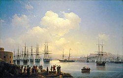 Painting of the Russian squadron in Sevastopol by Ivan Aivazovsky (1846)
 -
 The grave of Russian poet and artist Maximilian Voloshin
 -
 People at the Kazantip music festival in 2007


Sport
[edit]Following Crimea's vote to join Russia and subsequent annexation in March 2014, the top football clubs withdrew from the Ukrainian leagues. Some clubs registered to join the Russian leagues but the Football Federation of Ukraine objected. UEFA ruled that Crimean clubs could not join the Russian leagues but should instead be part of a Crimean league system. The Crimean Premier League is now the top professional football league in Crimea.[137]
A number of Crimean-born athletes have been given permission to compete for Russia instead of Ukraine at future competitions, including Vera Rebrik, the European javelin champion.[138] Due to Russia currently being suspended from all international athletic competitions, Rebrik participates in tournaments as a "neutral" athlete.[139]
Gallery
[edit]-

-

-

-

-
 Catholic church in Yalta
 -
 St. Vladimir's Cathedral, dedicated to the Heroes of Sevastopol (Crimean War).


See also
[edit]Notes
[edit]- ^
- Russian: Крым, romanised: Krym
- Ukrainian: Крим, romanised: Krym
- Crimean Tatar: Qırım, Къырым
- Ancient Greek: Κιμμερία, Ταυρική, romanised: Kimmería / Taurikḗ
- ^ Russia underwent a series of political changes in the period of the raids. The Grand Duchy of Moscow overthrew Turco-Mongol lordship, and expanded into the Tsardom of Russia in 1547. From 1721, following the reforms of Peter the Great, it was the Russian Empire.
References
[edit]- ^ a b Численность населения Российской Федерации по муниципальным образованиям на 1 января 2021 года [The population of the Russian Federation by municipalities as of January 1, 2021]. Russian Federal State Statistics Service (in Russian). Archived from the original (XLS) on 4 February 2021. Retrieved 31 January 2021.
- ^ a b c "Ukraine's president pledges to 'return' Russia-annexed Crimea". Al Jazeera. 23 August 2021. Retrieved 27 June 2024.
- ^ Maiolino Bisaccioni, Giacomo Pecini, Historia delle guerre ciuili di questi vltimi tempi, cioe, d'Inghilterra, Catalogna, Portogallo, Palermo, Napoli, Fermo, Moldauia, Polonia, Suizzeri, Francia, Turco. per Francesco Storti. Alla Fortezza, sotto il portico de' Berettari, 1655, p. 349: "dalla fortuna de Cosacchi dipendeva la sicurezza della Crimea". Nicolò Beregani, Historia delle guerre d'Europa, Volume 2 (1683), p. 251.
- ^ "State Papers". The Annual Register or a View of the History, Politics, and Literature for the Year 1783. J. Dodsley. 1785. p. 364. ISBN 9781615403851.
{{cite book}}: ISBN / Date incompatibility (help) - ^ Edward Gibbon, The History of the Decline and Fall of the Roman Empire, Volume 1, 306f. "the peninsula of Crim Tartary, known to the ancients under the name of Chersonesus Taurica"; ibid. Volume 10 (1788), p. 211: "The modern reader must not confound this old Cherson of the Tauric or Crimean peninsula with a new city of the same name". See also John Millhouse, English-Italian (1859), p. 597
- ^ Taylor, Adam (1 December 2021). "To understand Crimea, take a look back at its complicated history". Washington Post. ISSN 0190-8286. Retrieved 24 July 2024.
- ^ William Smith, Dictionary of Greek and Roman Geography (1854), s.v. Taurica Chersonesus. vol. ii, p. 1109.
- ^ Abū al-Fidā, Mukhtaṣar tāʾrīkh al-bashar ("A Brief History of Mankind"), 1315–1329; English translation of chronicle contemporaneous with Abū al-Fidā in The Memoirs of a Syrian Prince : Abul̓-Fidā,̕ sultan of Ḥamāh (672-732/1273-1331) by Peter M. Holt, Franz Steiner Verlag, 1983, pp. 38–39.
- ^ Edward Allworth, The Tatars of Crimea: Return to the Homeland: Studies and Documents, Duke University Press, 1998, p.6
- ^ W. Radloff, Versuch eines Wörterbuches der Türk-Dialecte (1888), ii. 745
- ^ George Vernadsky, Michael Karpovich, A History of Russia, Yale University Press, 1952, p. 53. "The name Crimea is to be derived from the Turkish word qirim (hence the Russian krym), which means "fosse" and refers more specifically to the Perekop Isthmus, the old Russian word perekop being an exact translation of the Turkish qirim."
- ^ The Proto-Turkic root is cited as *kōrɨ- "to fence, protect" Starling (citing Севортян Э. В. и др. [E. W. Sewortyan et al.], Этимологический словарь тюркских языков [An Etymological Dictionary of the Turkic languages] (1974–2000) 6, 76–78).
- ^ Edward Allworth, The Tatars of Crimea: Return to the Homeland : Studies and Documents, Duke University Press, 1998, pp. 5–7
- ^ Edith Hall, Adventures with Iphigenia in Tauris (2013), p. 176: "it was indeed at some point between the 1730s and the 1770s that the dream of recreating ancient 'Taurida' in the southern Crimea was conceived. Catherine's plan was to create a paradisiacal imperial 'garden' there, and her Greek archbishop Eugenios Voulgaris obliged by inventing a new etymology for the old name of Tauris, deriving it from taphros, which (he claimed) was the ancient Greek for a ditch dug by human hands."
- ^ Sulimirski & Taylor 1991, p. 558.
- ^ A. D. (Alfred Denis) Godley. Herodotus. Cambridge. Harvard University Press. vol. 2, 1921, p. 221.
- ^ See John Richard Krueger, specialist in the studies of Chuvash, Yakut, and the Mongolian languages in Edward Allworth, The Tatars of Crimea: Return to the Homeland : Studies and Documents, Duke University Press, 1998, p. 24.
- ^ Jews in Byzantium: Dialectics of Minority and Majority Cultures, BRILL, 2011, p.753, n. 102.
- ^ The Mongolian kori− is explained as a loan from Turkic by Doerfer Türkische und mongolische Elemente im Neupersischen 3 (1967), 450 and by Щербак, Ранние тюркско-монгольские языковые связи (VIII-XIV вв.) (1997) p. 141.
- ^ Compiled from original authors (1779). "The History of the Bosporus". An Universal History, From the Earliest Accounts to the Present Time. pp. 127–129.
- ^ John Julius Norwich (2013). A Short History of Byzantium. Penguin Books, Limited. p. 210. ISBN 978-0-241-95305-1.
- ^ Slater, Eric. "Caffa: Early Western Expansion in the Late Medieval World, 1261–1475." Review (Fernand Braudel Center) 29, no. 3 (2006): 271–83. JSTOR 40241665. pp. 271
- ^ Brian Glyn Williams (2013). "The Sultan's Raiders: The Military Role of the Crimean Tatars in the Ottoman Empire" (PDF). The Jamestown Foundation. p. 27. Archived from the original (PDF) on 21 October 2013. Retrieved 30 March 2015.
- ^ Mikhail Kizilov (2007). "Slave Trade in the Early Modern Crimea From the Perspective of Christian, Muslim, and Jewish Sources". Journal of Early Modern History. 11 (1–2): 1. doi:10.1163/157006507780385125.
- ^ M. S. Anderson (December 1958). "The Great Powers and the Russian Annexation of the Crimea, 1783-4". The Slavonic and East European Review. 37 (88): 17–41. JSTOR 4205010. which would later see Russia's frontier expand westwards to the Dniester.
- ^ "Crimean War (1853–1856)". Gale Encyclopedia of World History: War. 2. 2008. Archived from the original on 16 April 2015.
- ^ "History". blacksea-crimea.com. Archived from the original on 4 April 2007. Retrieved 28 March 2007.
- ^ The Strategic Use of Referendums: Power, Legitimacy, and Democracy By Mark Clarence Walke (page 107)
- ^ National Identity and Ethnicity in Russia and the New States of Eurasia edited by Roman Szporluk (page 174)
- ^ Paul Kolstoe; Andrei Edemsky (January 1995). "The Eye of the Whirlwind: Belarus and Ukraine". Russians in the Former Soviet Republics. C. Hurst & Co. Publishers. p. 194. ISBN 978-1-85065-206-9.
- ^ Doyle, Don H., ed. (2010). Secession as an International Phenomenon: From America's Civil War to Contemporary Separatist Movements. University of Georgia Press. p. 285. ISBN 9780820337371.
- ^ "Ukraine leader Turchynov warns of 'danger of separatism'". Euronews. 25 February 2014. Archived from the original on 4 March 2016. Retrieved 10 March 2015.
- ^ "Russia puts military on high alert as Crimea protests leave one man dead". The Guardian. 26 February 2014. Retrieved 27 February 2014.
- ^ Головко, Володимир (2021). "ЗАХОПЛЕННЯ БУДІВЛІ ВЕРХОВНОЇ РАДИ АВТОНОМНОЇ РЕСПУБЛІКИ КРИМ 2014". Енциклопедія історії України.
- ^ Fedorchak, Viktoriya (19 March 2024). The Russia-Ukraine War: Towards Resilient Fighting Power. Taylor & Francis. pp. 44–45. ISBN 978-1-040-00731-0.
- ^ Andrew Higgins; Steven Erlanger (27 February 2014). "Gunmen Seize Government Buildings in Crimea". The New York Times. Retrieved 25 June 2022.
- ^ Marxsen, Christian (2014). "The Crimea Crisis – An International Law Perspective" (PDF). Max-Planck-Institut. Archived from the original (PDF) on 11 February 2024. Retrieved 25 June 2022.
- ^ a b "General Assembly Adopts Resolution Calling upon States Not to Recognize Changes in Status of Crimea Region". UN Press. 27 March 2014.
- ^ a b "Resolution adopted by the General Assembly on 27 March 2014" (PDF). United Nations Department of General Assembly and Conference Management. 1 April 2014. Retrieved 27 June 2024.
- ^ a b "Temporary Occupation of Crimea and City of Sevastopol". Ministry of Foreign Affairs of Ukraine. 22 July 2022. Retrieved 8 July 2024.
- ^ The Crimean Mountains may also be referred to as the Yaylâ Dağ or Alpine Meadow Mountains.
- ^ a b Kropotkin, Peter Alexeivitch; Bealby, John Thomas (1911). . In Chisholm, Hugh (ed.). Encyclopædia Britannica. Vol. 07 (11th ed.). Cambridge University Press. pp. 449–450, see line one.
...ancient Tauris or Tauric Chersonese, called by the Russians by the Tatar name Krym or Crim
- ^ "Three canyons trekking (Chernorechensky Canyon, Uzunja Canyon and Grand Crimean Canyon). Journey by a mountainous part of Crimea". extremetime.ru. Retrieved 1 May 2016.
- ^ Jaoshvili, Shalva (2002). The rivers of the Black Sea (PDF). Copenhagen: European Environment Agency. p. 15. OCLC 891861999. Archived (PDF) from the original on 10 March 2016.
- ^ "Дерекойка, река" [Derekoika river]. Путеводитель по отдыху в Ялте.
- ^ Jaoshvili 2002, p. 34
- ^ Grinevetsky, Sergei R.; et al., eds. (2014). "Alma, Kacha River". The Black Sea Encyclopedia. Berlin: Springer. p. 38 and 390. ISBN 978-3-642-55226-7.
- ^ a b "Dam leaves Crimea population in chronic water shortage". Al-Jazeera. 4 January 2017.
- ^ Mirzoyeva, Natalya; et al. (2015). "Radionuclides and mercury in the salt lakes of the Crimea". Chinese Journal of Oceanology and Limnology. 33 (6): 1413–1425. Bibcode:2015ChJOL..33.1413M. doi:10.1007/s00343-015-4374-5. ISSN 0254-4059. S2CID 131703200.
- ^ Kayukova, Elena (2014). "Resources of Curative Mud of the Crimea Peninsula". In Balderer, Werner; Porowski, Adam; Idris, Hussein; LaMoreaux, James W. (eds.). Thermal and Mineral Waters. Berlin: Springer. pp. 61–72. doi:10.1007/978-3-642-28824-1_6. ISBN 978-3-642-28823-4.
- ^ Bogutskaya, Nina; Hales, Jennifer. "426: Crimea Peninsula". Freshwater Ecoregions of the World. The Nature Conservancy. Archived from the original on 16 January 2017. Retrieved 10 March 2016.
- ^ "In Crimea has receded one of the largest reservoirs". News from Ukraine. 19 October 2015. Archived from the original on 23 May 2016. Retrieved 10 March 2016.
- ^ Tymchenko, Z. North Crimean Canal. History of construction. (Russian) Ukrainska Pravda. 13 May 2014 (Krymskiye izvestiya. November 2012)
- ^ "Pray For Rain: Crimea's Dry-Up A Headache For Moscow, Dilemma For Kyiv". Radio Free Europe/Radio Liberty. 29 March 2020.
- ^ "Crimea Drills For Water As Crisis Deepens In Parched Peninsula". Radio Free Europe/Radio Liberty. 25 October 2020.
- ^ Salem, Harriet; Makarova, Ludmila (28 March 2014). "Crimean annexation brings dacha prize closer for Putin". The Guardian. ISSN 0261-3077. Retrieved 24 July 2024.
- ^ a b c d e f g h i j k l m n o p q r s t u v "Description of the Crimean Climate". Autonomous Republic of Crimea Information Portal. Archived from the original on 1 September 2010. Retrieved 1 October 2016.
- ^ a b c d e f "Geographical Survey of the Crimean region". Autonomous Republic of Crimea Information Portal. Archived from the original on 3 September 2010. Retrieved 1 October 2016.
- ^ "Climate in Crimea, Weather in Yalta: How Often Does it Rain in Crimea?". Blacksea-crimea.com. Archived from the original on 3 March 2010. Retrieved 10 April 2014.
- ^ "Russia-Ukraine Update: Crimea Attracts More Than 4 Million Tourists Despite Annexation". International Business Times. 14 October 2015. Retrieved 1 May 2016.
- ^ "What is the Crimea, and why does it matter?". The Daily Telegraph. 2 April 2014. Archived from the original on 10 January 2022. Retrieved 10 April 2014.
- ^ "Crimea Annexation 'Robbery on International Scale'". CBN News. CBN News. 19 March 2014. Retrieved 19 March 2014.
- ^ "Черное море признано одним из самых неблагоприятных мест для моряков" [The Black Sea is recognised as one of the most unwelcoming places for sailors]. International Transport Workers' Federation. BlackSeaNews. 27 May 2013. Retrieved 20 September 2013.
- ^ "Валовой региональный продукт::Мордовиястат". mrd.gks.ru. Archived from the original on 17 February 2018. Retrieved 19 February 2018.
- ^ Yurchenko, Stas; Dzhabbarov, Usein; Bigg, Claire (5 July 2014). "Tourist Season A Washout in Annexed Crimea". Radio Free Europe/Radio Liberty.
- ^ Итоги сезона-2013 в Крыму: туристов отпугнул сервис и аномальное похолодание. Segodnya.ua (in Russian). Retrieved 10 June 2017.
- ^ "Справочная информация о количестве туристов, посетивших Республику Крым за 2014 год" (PDF). Министерство курортов и туризма Республики Крым. Retrieved 10 June 2017.
- ^ "Справочная информация о количестве туристов, посетивших республику крым за 2016 год" (PDF). Министерство курортов и туризма Республики Крым. Retrieved 10 June 2017.
- ^ a b c "Autonomous Republic of Crimea – Information card". Cabinet of Ministers of Ukraine. Archived from the original on 21 January 2007. Retrieved 22 February 2007.
- ^ "Russia to cover Crimea's $1.5 billion budget deficit with state funds- TV". Reuters. 19 March 2014. Retrieved 17 July 2018.
- ^ Daane, Kent M.; Cooper, Monica L.; Triapitsyn, Serguei V.; Walton, Vaughn M.; Yokota, Glenn Y.; Haviland, David R.; Bentley, Walt J.; Godfrey, Kris E.; Wunderlich, Lynn R. (2008). "Vineyard managers and researchers seek sustainable solutions for mealybugs, a changing pest complex". California Agriculture. 62 (4). UC Agriculture and Natural Resources (UC ANR): 167–176. doi:10.3733/ca.v062n04p167. ISSN 0008-0845. S2CID 54928048.
- ^ a b c Critchley, Brian R. (1998). "Literature review of sunn pest Eurygaster integriceps Put. (Hemiptera, Scutelleridae)". Crop Protection. 17 (4). International Association for the Plant Protection Sciences (Elsevier): 271–287. Bibcode:1998CrPro..17..271C. doi:10.1016/s0261-2194(98)00022-2. ISSN 0261-2194. S2CID 83631999.
- ^ "Pests - Eurygaster maura Linnaeus - Sunn Pest". AgroAtlas. 7 May 2015. Retrieved 15 April 2021.
- ^ Khaustov AA (2000). "Mites of the genus Elattoma (Acariformes, Pygmephoridae) from Crimea and North-West Russia". Vestnik Zoologii. 34 (1/2): 77–83.
- ^ Hofstetter, R.W.; Moser, J.C. (7 January 2014). "The Role of Mites in Insect-Fungus Associations". Annual Review of Entomology. 59 (1). Annual Reviews: 537–557. doi:10.1146/annurev-ento-011613-162039. ISSN 0066-4170. PMID 24188072.
- ^ Gloystein, Henning (7 March 2014). "Ukraine's Black Sea gas ambitions seen at risk over Crimea". Reuters. Retrieved 7 March 2014.
- ^ "Ukrainian Gas Pipelines". East European Gas Analysis. 9 February 2013. Retrieved 8 March 2014.
- ^ "Ukraine crisis in maps". BBC. 3 May 2014. Retrieved 7 March 2014.
- ^ "Investment portal of the Autonomous Republic of Crimea – investments in Crimea – "Chernomorneftegaz" presented a program of development till 2015". Invest-crimea.gov.ua. Archived from the original on 26 March 2014. Retrieved 8 March 2014.
- ^ Генерация электроэнергии в Крыму выросла до 963 МВт (in Russian). 21 January 2016. Archived from the original on 14 September 2016. Retrieved 11 August 2016.
- ^ "Crimea goes dark after Russian shutdown leaves the peninsula without power". Business Insider. 28 July 2017. Retrieved 28 July 2017.
- ^ "Putin orders military exercise as protesters clash in Crimea". Reuters. 18 April 2016. Retrieved 24 April 2016.
- ^ "Massive explosion reported on Crimea's Kerch bridge". 8 October 2022. Archived from the original on 8 October 2022. Retrieved 17 July 2023.
- ^ "Traffic stopped on Crimean Bridge, reports of blasts". Reuters. 17 July 2023. Retrieved 17 July 2023.
- ^ "The longest trolleybus line in the world!". blacksea-crimea.com. Archived from the original on 3 January 2014. Retrieved 15 January 2007.
- ^ "История "Артека"" [History of Artek]. Артек. 2010. Archived from the original on 24 March 2015. (This has a slow to load URL.)
- ^ a b "Артек – международный детский центр" [The International Children Center Artek], Города и области Украины (Cities and regions of Ukraine), 7 June 2014, archived from the original on 7 June 2014
- ^ "Артек" [Entry on Artek], Great Soviet Encyclopedia, 3rd ed., retrieved 22 June 2020
- ^ National Geographic Society (December 2012). "Best Trips 2013, Crimea". National Geographic. Archived from the original on 30 November 2012. Retrieved 29 March 2015.
- ^ "Australia imposes sanctions on Russians after annexation of Crimea from Ukraine". Australian Broadcasting Corporation. 19 March 2014. Retrieved 29 March 2015.
- ^ "Japan imposes sanctions against Russia over Crimea independence". Fox News Channel. 18 March 2014. Retrieved 29 March 2015.
- ^ "EU sanctions add to Putin's Crimea headache". EUobserver. 18 December 2014. Retrieved 28 March 2015.
- ^ "Special Economic Measures (Ukraine) Regulations". Canadian Justice Laws Website. 17 March 2014. Retrieved 30 March 2015.
- ^ "Australia and sanctions – Consolidated List – Department of Foreign Affairs and Trade". Dfat.gov.au. 25 March 2015. Archived from the original on 29 February 2020. Retrieved 29 March 2015.
- ^ "Declaration by the High Representative on behalf of the European Union on the alignment of certain third countries with the Council Decision 2014/145/CFSPconcerning restrictive measures in respect of actions undermining or threatening the territorial integrity, sovereignty and independence of Ukraine" (PDF). European Union. 11 April 2014. Retrieved 29 March 2015.
- ^ "Crimea hit by multiple sanctions as power, transport and banking communications are cut off". Kyiv Post. Retrieved 28 March 2015.
- ^ "Visa and MasterCard quit Crimea over US sanctions". Euronews. Retrieved 28 March 2015.
- ^ Makortoff, Kalyeena; correspondent, Kalyeena Makortoff Banking (6 March 2022). "Mastercard and Visa block in Russia does not stop domestic purchases". The Guardian. ISSN 0261-3077. Retrieved 24 July 2024.
{{cite news}}:|last2=has generic name (help) - ^ "What happened to Russian fintech after the global 'cancelling'". Finextra Research. 7 January 2023. Retrieved 24 July 2024.
- ^ "Cards of Russia's Mir payment system will start working in Crimea in December — official". TASS. Retrieved 24 July 2024.
- ^ "MasterCard ready to resume operation in Crimea after sanctions lifted". TASS. Retrieved 24 July 2024.
- ^ "Operations with Visa, MasterCard cards may resume in Crimea by year-end — NSPC CEO". TASS. Retrieved 24 July 2024.
- ^ "Sanctions trump patriotism for Russian banks in Crimea". Reuters. 9 April 2014. Retrieved 1 August 2019.
- ^ "Kyiv vows to restore Ukrainian rule over Crimea to re-establish 'world law and order'". ABC NEWS. 23 August 2022.
- ^ "Results of Census: Population of Crimea is 2.284 Million People – Information agency "Krym Media"". Archived from the original on 4 November 2015. Retrieved 13 February 2016.
- ^ "Regions of Ukraine / Autonomous Republic of Crimea". 2001 Ukrainian Census. Retrieved 16 December 2006.
- ^ Таблицы с итогами Федерального статистического наблюдения "Перепись населения в Крымском федеральном округе" [Tables with the results of the Federal Statistical Observation "Population Census in the Crimean Federal District"] (.xlsx). gks.ru (in Russian). Rosstat. 14–25 October 2014. Retrieved 8 July 2024.
- ^ "Census of the population is transferred to 2016". Dzerkalo Tzhnia (in Ukrainian). 20 September 2013. Archived from the original on 2 July 2015. Retrieved 7 March 2014.
- ^ "Results / General results of the census / Linguistic composition of the population / Autonomous Republic of Crimea". 2001 Ukrainian Census.
- ^ "Crimean Tatar language in danger". avrupatimes.com. 19 February 2013. Retrieved 31 March 2015.
- ^ "Crimean Tatar". Ethnologue. 2009. Archived from the original on 5 March 2016. Retrieved 31 March 2015.
- ^ "Europa e Mediterraneo d'Italia. L'italiano nelle comunità storiche da Gibilterra a Costantinopoli - 10. Gli italiani di Crimea | Treccani, il portale del sapere". www.treccani.it (in Italian). Retrieved 22 May 2023.
- ^ a b c d e f O'Neill, Kelly Ann (2017). Claiming Crimea: A History of Catherine the Great's Southern Empire. New Haven: Yale University Press. p. 30. ISBN 978-0-300-23150-2. OCLC 1007823334.
- ^ These numbers exclude the population numbers for Berdyansky, Dneprovsky and Melitopolsky Uyezds, which were on mainland. See the administrative divisions of the Taurida Governorate
- ^ "The First General Census of the Russian Empire of 1897 – Taurida Governorate". demoscope.ru. Демоскоп. Retrieved 18 June 2014.
- ^ "Демоскоп Weekly – Приложение. Справочник статистических показателей". demoscope.ru.
- ^ "Демоскоп Weekly – Приложение. Справочник статистических показателей". demoscope.ru.
- ^ "Демоскоп Weekly – Приложение. Справочник статистических показателей". demoscope.ru.
- ^ Crimea – Dynamics, challenges and prospects / edited by Maria Drohobycky. Page 73
- ^ Crimea – Dynamics, challenges and prospects / edited by Maria Drohobycky. Page 72
- ^ a b this combines the figures for the Autonomous Republic of Crimea and Sevastopol, listing groups of more than 5,000 individuals. "About number and composition population of Autonomous Republic of Crimea by data All-Ukrainian population census". 2001 Ukrainian Census. Retrieved 26 October 2015.; "Sevastopol". 2001 Ukrainian Census. Retrieved 26 October 2015.;"About number and composition population of Ukraine by data All-Ukrainian Population Census 2001". 2001 Ukrainian Census. Retrieved 26 October 2015.
- ^ Итоги Переписи Населения В Крымском Федеральном Округе [Censuses in Crimean Federal District], Таблицы с итогами Федерального статистического наблюдения "Перепись населения в Крымском федеральном округе" [Tables with the results of the Federal Statistical observation "Census in the Crimean Federal District"] 4.1 Национальный Состав Населения Archived 31 March 2022 at the Wayback Machine [4.1. National composition of population]
- ^ a b "About number and composition population of Autonomous Republic of Crimea by data All-Ukrainian population census". 2001 Ukrainian Census. Retrieved 24 March 2014.
- ^ Pohl, J. Otto. The Stalinist Penal System: A Statistical History of Soviet Repression and Terror. Mc Farland & Company, Inc, Publishers. 1997. "23". Archived from the original on 4 June 2000.
- ^ Arad, Yitzhak (January 2009). The Holocaust in the Soviet Union. U of Nebraska Press. p. 211. ISBN 978-0803222700.
- ^ "The Deportation and Destruction of the German Minority in the USSR" (PDF)
- ^ "On Germans Living on the Territory of the Ukrainian SSR"
- ^ "NKVD Arrest List Archived 16 December 2011 at the Wayback Machine" (PDF)
- ^ "A People on the Move: Germans in Russia and in the Former Soviet Union: 1763 – 1997 Archived 1 August 2020 at the Wayback Machine. North Dakota State University Libraries.
- ^ "The Persecution of Pontic Greeks in the Soviet Union" (PDF)
- ^ a b "Public Opinion Survey Residents of the Autonomous Republic of Crimea" (PDF)., The sample consisted of 1,200 permanent Crimea residents older than the age of 18 and eligible to vote and is representative of the general population by age, gender, education and religion.
- ^ Russia seeks to crush Ukrainian Orthodox Church in Crimea for helping resist Russification, Ukrainian Independent Information Agency (11 October 2018)
- ^ (in Russian) Статус епархий в Крыму остался неизменным, заявили в УПЦ Московского патриархата NEWSru, 10 March 2015.
(in Russian) The Ukrainian Church of the Moscow Patriarchate demanded the return of the Crimea, RBK Group (18 August 2014) - ^ Emiramzaieva, A. S. (2020). "ТВОРЧІСТЬ ТА ЖИТТЯ МАХМУДА КИРИМЛИ У ЛІТЕРАТУРОЗНАВЧОМУ ВИСВІТЛЕННІ: ІСТОРІЯ ТА ПЕРСПЕКТИВИ ДОСЛІДЖЕННЯ" [MAKHMUD KIRIMLI’S LIFE AND WORKS IN LITERARY ASPECT: HISTORY AND PERSPECTIVES OF STUDY] (PDF). Scientific Notes of Taurida National V.I. Vernadsky University, Series Philology. Social Communications. 4 (1): 110–114. doi:10.32838/2663-6069/2020.1-4/20.
- ^ Rogachevsky, Alexander. "Ivan Aivazovsky (1817–1900)". Tufts University. Archived from the original on 19 March 2014. Retrieved 10 December 2013.
- ^ Stephens, Heidi (15 May 2016). "Eurovision 2016: Ukraine's Jamala wins with politically charged 1944". The Guardian. Retrieved 18 May 2016.
- ^ "UEFA-backed league starts play in Crimea". Yahoo Sports. 23 August 2015. Archived from the original on 26 September 2022. Retrieved 13 February 2016.
- ^ "Ukrainian Sport Minister urges Federations not to let athletes switch to Russia without serving qualifying period". 8 December 2015. Retrieved 2 May 2016.
- ^ 14 Russians bid to take part in IAAF World Championships, TASS news agency (5 July 2017)
Sources
[edit]- Sulimirski, Tadeusz; Taylor, T. F. (1991). "The Scythians". In Boardman, John; Edwards, I. E. S.; Hammond, N. G. L.; Sollberger, E.; Walker, C. B. F. (eds.). The Assyrian and Babylonian Empires and other States of the Near East, from the Eighth to the Sixth Centuries B.C. The Cambridge Ancient History. Vol. 3. Cambridge, United Kingdom: Cambridge University Press. pp. 547–590. ISBN 978-1-139-05429-4.
External links
[edit] Definitions from Wiktionary
 Media from Commons
 News from Wikinews
 Travel information from Wikivoyage
 Data from Wikidata
- Kropotkin, Peter Alexeivitch; Bealby, John Thomas (1911). . In Chisholm, Hugh (ed.). Encyclopædia Britannica. Vol. 7 (11th ed.). Cambridge University Press. pp. 449–450.
- Lists of Crimean Tartar villages emptied in the May 1944 deportations, and most of them renamed in Russian
| Worlds | |||||||||||||||||||||||||||||||||||||||||||||||||||||||||||||||
|---|---|---|---|---|---|---|---|---|---|---|---|---|---|---|---|---|---|---|---|---|---|---|---|---|---|---|---|---|---|---|---|---|---|---|---|---|---|---|---|---|---|---|---|---|---|---|---|---|---|---|---|---|---|---|---|---|---|---|---|---|---|---|---|
| Hemispheres | |||||||||||||||||||||||||||||||||||||||||||||||||||||||||||||||
| Landmasses | |||||||||||||||||||||||||||||||||||||||||||||||||||||||||||||||
| Continents |
| ||||||||||||||||||||||||||||||||||||||||||||||||||||||||||||||
| Geopolitical
regions |
| ||||||||||||||||||||||||||||||||||||||||||||||||||||||||||||||
| Islands |
| ||||||||||||||||||||||||||||||||||||||||||||||||||||||||||||||
| Oceans | |||||||||||||||||||||||||||||||||||||||||||||||||||||||||||||||
| Other waterbodies | |||||||||||||||||||||||||||||||||||||||||||||||||||||||||||||||
| Rim | |||||||||||||||||||||||||||||||||||||||||||||||||||||||||||||||
| Polar | |||||||||||||||||||||||||||||||||||||||||||||||||||||||||||||||
| International | |
|---|---|
| National | |
| Geographic | |
| Other | |
Crimea
View on GrokipediaName and Etymology
Historical Names and Usage
In antiquity, the Crimean Peninsula was known to the ancient Greeks as Taurica or the Tauric Chersonese, names derived from the indigenous Tauri people who inhabited the region and practiced rituals including human sacrifice, as reported by classical authors like Herodotus.[9] The term Chersonesos in Greek translates to "peninsula," reflecting the geographical feature, with the specific site of the Greek colony near modern Sevastopol founded around the 5th century BCE by Dorian settlers from Heraclea Pontica.[10] This nomenclature extended to the broader peninsula under Roman and Byzantine influence, where it was referred to as Chersonesus Taurica.[11] During the medieval period, following Mongol invasions in the 13th century, the name Qırım (or Krym) emerged in Turkic languages, initially denoting a fortified city in the interior—now Staryi Krym—which served as a provincial capital under the Golden Horde.[12] This toponym, possibly originating from Turkic qirum meaning "fosse" or "trench" (referring to defensive earthworks), or from qurum signifying "protection" or "defense," gradually applied to the entire peninsula by the 15th century under the Crimean Khanate, a successor state to the Golden Horde ruled by Giray dynasty descendants of Genghis Khan.[13] [14] Alternative etymologies link Qırım to Mongolian kherem ("strength") or Greek kremos ("steep bank"), though these remain speculative without definitive archaeological or textual consensus.[15] The modern English name Crimea entered European usage via Italian Crim, adapted from Tatar Qırım, appearing in maps and accounts from the Renaissance onward as Ottoman and Russian interactions increased; for instance, Genoese traders in the 14th century referred to coastal enclaves like Caffa (modern Feodosia) but adopted the broader Qırım for the hinterland.[14] Russian imperial adoption post-1783 annexation retained Крым (Krym), transliterating the Turkic form while suppressing earlier Slavic or Greek usages in official nomenclature to align with steppe nomadic heritage. The Ukrainian name is Крим (Krym). The modern Crimean Tatar name is Qırım.[16] Historical names thus mirrored successive dominions: Greek colonial emphasis on ethnography and geography, Turkic-Mongol focus on administrative centers and fortifications, underscoring the peninsula's role as a contested frontier rather than a monolithic identity.[17]Geography
Physical Landscape
Crimea occupies a diamond-shaped peninsula extending into the northern Black Sea, covering roughly 27,000 square kilometers, with its northern and central expanses dominated by flat, semiarid steppe plains suitable for agriculture but prone to aridity.[18] The terrain rises dramatically in the south, where the Crimean Mountains form a series of parallel ridges running east-west along the southeastern coast, approximately 8 to 12 kilometers inland from the shoreline.[18] These mountains, composed primarily of limestone and featuring cuestas in the outer and inner ridges transitioning to the main central range, reach their apex at Roman-Kosh, with an elevation of 1,545 meters above sea level.[19][20][21] The peninsula connects to the mainland solely through the Isthmus of Perekop, a narrow land bridge 5 to 7 kilometers wide separating Karkinit Bay from the Syvash lagoons, historically fortified due to its strategic constriction.[22] To the northwest, the Syvash—known as the "Putrid Sea" for its hypersaline, shallow waters exhibiting vivid colors from algal blooms and chemical gradients—forms a complex of lagoons up to 35 kilometers wide, with depths rarely exceeding 1 meter and high evaporation rates fostering salt extraction.[23] Eastern boundaries include the Kerch Strait linking to the Sea of Azov, while southern and western coasts feature rugged cliffs interspersed with bays, contrasting the sandy northern shores.[18] Hydrography is sparse, with over 1,600 rivers and streams totaling about 6,000 kilometers in length, most being short and ephemeral; the Salhir (Salgir) stands as the principal waterway, stretching 232 kilometers from mountainous headwaters through the central plains to discharge into the Sea of Azov, draining a basin of 4,000 square kilometers.[24] These rivers support limited irrigation but often dwindle in summer due to low precipitation and porous karst geology in upland areas.[24]Climate and Environment
Crimea features a diverse climate ranging from humid subtropical along the southern Black Sea coast to semi-arid steppe in the north and continental in the interior mountains. The peninsula's average annual temperature is approximately 13°C, with August highs reaching 24°C and January lows around 0°C, though regional variations are significant.[25] In Simferopol, the central city, annual temperatures fluctuate between -6°C in winter and 30°C in summer, with average precipitation of 505 mm concentrated in fall and winter.[26] Southern coastal areas experience milder winters averaging 4–5°C and warmer summers up to 28°C, with annual rainfall of 400–600 mm, while northern steppes receive only 300–400 mm, leading to drier conditions and higher evaporation rates.[27] Mountainous regions in the Crimean Mountains see cooler averages around 5.7°C annually and increased precipitation up to 1,000 mm due to orographic effects. The environment of Crimea includes steppe plains, forested mountains, and coastal ecosystems, supporting high biodiversity within the Crimean Submediterranean forest complex ecoregion. This ecoregion features mixed forests of oak, beech, pine, and junipers, alongside sub-Mediterranean species like pistachio and unique endemics, with over 2,775 species of vascular plants recorded across the peninsula.[28] Fauna includes diverse mammals such as roe deer and foxes, over 260 bird species, and reptiles adapted to varied habitats from salt lakes to marine waters.[29] The Syvash lagoon system and coastal zones host halophytic vegetation and migratory birds, while the mountains preserve relict forests and meadows.[30] Protected areas cover significant portions of Crimea's landscapes, with more than 150 reserves and parks safeguarding ecosystems. The Crimean Nature Reserve, spanning 44,175 hectares north of Massandra, protects mountain-forest and steppe biodiversity, including 1,180 plant species and 27 mammal species.[31] Other key sites include the Yalta Mountain-Forest Reserve with over 1,400 vascular plants, the Karadag Nature Reserve encompassing volcanic mountains and marine habitats, and the Kazantip Reserve focused on coastal steppe. These areas maintain endemic flora and fauna amid broader pressures.[32] Environmental challenges have intensified since 2014, primarily due to water scarcity following the blockade of the North Crimean Canal, which previously supplied 85% of agricultural water from the Dnipro River.[33] This led to a 92% reduction in irrigated land in eastern Crimea by 2017, groundwater depletion, and salinization of soils and aquifers, exacerbating drought effects in a region with limited rainfall.[33] Additional issues include pollution from military activities, industrial emissions, and construction, contributing to river drying, air and water contamination, and biodiversity loss in coastal zones.[34] Militarization has introduced ordnance residues and habitat fragmentation, while overexploitation and climate variability further strain resources like the shrinking Sasyk-Sivash lakes.[35] Despite these pressures, core protected zones retain relative ecological integrity.[35]Strategic Geographical Position
Crimea comprises a peninsula extending southward into the Black Sea from the northern coast, connected to the mainland by the narrow Isthmus of Perekop, which spans 5 to 7 kilometers in width. This constricted land bridge creates a defensible chokepoint, historically fortified to regulate access and repel invasions from the north.[36][37] Positioned between the Black Sea to the south and west and the Sea of Azov to the northeast, Crimea commands the Kerch Strait, a waterway with a minimum width of approximately 4 kilometers that serves as the exclusive maritime gateway to the Sea of Azov. Dominion over this strait facilitates control of navigation, trade, and military transits, amplifying influence over adjacent coastal regions including southern Russia and eastern Ukraine.[38][39] Sevastopol's harbor on the southwestern shore features naturally deep waters and topographic sheltering, enabling secure berthing for large naval vessels and year-round operations unaffected by ice. As the principal base for Russia's Black Sea Fleet, it supports power projection through the Turkish Straits into the Mediterranean, while proximity to the Caucasus enhances monitoring of energy corridors and regional conflicts.[40][41] The southern Crimean Mountains provide elevated terrain for radar and artillery oversight, contrasting with the expansive northern plains ideal for air bases and supply depots, thereby integrating land, sea, and air advantages into a cohesive strategic posture at the nexus of Europe, the Middle East, and Central Asia.[42][43]History
Prehistoric and Ancient Eras
Archaeological evidence indicates human occupation in Crimea during the Middle Paleolithic period, with sites such as Buran-Kaya III and others yielding artifacts dated to more than 50,000 years ago, associated with Neanderthal populations.[44] Over 100 Middle Paleolithic localities have been documented across the peninsula, reflecting repeated use of caves and rock shelters for hunting and processing game in a landscape of steppes and mountains.[45] Transition to the Upper Paleolithic involved early modern humans, with genetic analysis of remains from Buran-Kaya III suggesting persistent settlement around 37,000 years ago, marking some of the earliest semi-permanent habitation in Europe amid fluctuating climate conditions.[46] [47] Neolithic and Chalcolithic phases show continuity with Mesolithic hunter-gatherers adapting to post-glacial environments, though evidence remains sparser, including tools from coastal and riverine sites indicating seasonal exploitation of marine resources.[48] Bronze Age developments aligned with broader Pontic-Caspian steppe cultures, featuring kurgan burials and metallurgy linked to pastoral nomadism, precursors to later Iron Age groups.[49] In the early Iron Age, around the 8th century BCE, Cimmerian nomads, skilled horse warriors originating from the northern steppes, dominated the region before being displaced southward by Scythian incursions.[50] Scythians, Iranian-speaking equestrian nomads, established control over the Crimean steppes by the 7th century BCE, engaging in raids and trade while coexisting uneasily with indigenous hill tribes known to Greeks as Tauri, who practiced human sacrifice and inhabited the peninsula's mountainous interior.[51] Greek colonization began in the 6th century BCE, with Milesian traders founding outposts like Panticapaeum on the Kerch Strait for grain export to the Aegean.[50] By the mid-5th century BCE, Heraclea Pontica established Chersonesus Taurica near modern Sevastopol as a democratic polis for agriculture and defense against Taurian raids.[10] These poleis unified under the Spartocid dynasty around 438 BCE, forming the Bosporan Kingdom, a Hellenistic state blending Greek urbanism with Scythian alliances, controlling eastern Crimea and the Taman Peninsula through tolls on the Cimmerian Bosporus and exports of wheat, fish, and slaves.[52] The kingdom reached prosperity in the 1st-2nd centuries CE under Roman client kings, minting coinage and building monumental architecture, before Gothic migrations and Hunnic pressures fragmented it by the 4th century CE.[53]Medieval and Early Modern Periods
Following the withdrawal of centralized Roman authority in the 4th and 5th centuries CE, Germanic Gothic tribes migrated into the Crimean Peninsula, establishing a polity known as Crimean Gothia primarily in the southern mountainous regions. This Gothic settlement, originating from East Germanic migrations during the 3rd and 4th centuries, persisted as a distinct Christian community under loose Byzantine oversight, with archaeological evidence of cave towns and fortifications indicating a blend of Gothic and Byzantine cultural elements by the early medieval period.[54][55] The Byzantine Empire retained significant influence over southern Crimea, particularly through the city of Chersonesus (modern-day vicinity of Sevastopol), which served as a key ecclesiastical and administrative center. In the 8th to 10th centuries, the northern parts of the peninsula fell under the control of the Khazar Khaganate, a Turkic semi-nomadic state that dominated the steppe regions and facilitated trade routes. Kievan Rus' exerted intermittent influence, notably when Prince Vladimir the Great was baptized in Chersonesus in 988 CE, an event that catalyzed the Christianization of Rus' territories.[56][57] Nomadic incursions by Pechenegs and Cumans disrupted settled areas in the 11th and 12th centuries, while Genoese merchants began establishing coastal trading enclaves around 1200 CE, securing permissions from local rulers for settlements like Caffa (modern Feodosia). The Mongol invasion under Batu Khan in the 1230s–1240s integrated Crimea into the Golden Horde, with the peninsula serving as a peripheral khanate territory focused on tribute collection and Silk Road commerce. Genoese colonies expanded post-1266, when Genoa acquired Caffa from the Golden Horde, forming the Lordship of Gazaria that controlled key Black Sea ports and silk trade monopolies until the 15th century.[58][59] In the early modern period preceding the formal Crimean Khanate, the disintegration of the Golden Horde from the mid-14th century led to the rise of local Tatar principalities (beyliks) in Crimea, often in tense coexistence with Genoese outposts and remnant Gothic communities. Ottoman expansion influenced the region, with the Sublime Porte supporting Muslim Tatar elites against Mongol successors, setting the stage for consolidated khanate rule by the 1440s. These dynamics involved frequent raids, trade rivalries, and shifting alliances, with the Genoese maintaining fortified strongholds like Sudak until their expulsion amid power vacuums.[60][61]Crimean Khanate Era
The Crimean Khanate was established in 1441 by Hacı I Giray, a descendant of Jochi Khan, following the fragmentation of the Golden Horde, with Crimea serving as its core territory.[62] Hacı I Giray consolidated power by defeating rival claimants and Genoese forces in the region, marking the khanate as a successor state to Mongol rule in the area.[62] The capital was relocated to Bakhchysarai in the early 16th century, where the Khan's Palace became the administrative and symbolic center of the state.[63] In 1475, following the Ottoman conquest of Genoese-held Caffa, the khanate became a vassal of the Ottoman Empire, providing military support in exchange for protection and autonomy in internal affairs.[64] This alliance enabled the khans, from the Giray dynasty, to maintain nominal independence while aligning against common foes like Muscovy and the Polish-Lithuanian Commonwealth. The khanate's military consisted primarily of nomadic cavalry, numbering up to 40,000 horsemen at its peak, organized into hordes including the Nogai.[65] The economy relied on pastoral nomadism, supplemented by agriculture in settled areas, trade, and extensive slave raiding into Eastern European territories.[66] Raids by Crimean Tatars and Nogai forces captured hundreds of thousands of Slavic populations, primarily Ruthenians, Russians, and Poles over centuries, with slaves sold in markets like Caffa to supply Ottoman demands, forming a cornerstone of fiscal revenue.[67] Specific incursions, such as the 16th-century raids into Red Ruthenia, yielded up to 18,000 captives in single operations, fueling both economic and demographic dynamics.[67] [68] Both the Russian Tsardom and the Polish-Lithuanian Commonwealth provided customary diplomatic gifts to the Crimean Khanate in exchange for formal commitments to prevent raids by subordinate Nogai and Tatar groups. Moscow preferred regular annual payments as part of long-term peace arrangements with the khans. The PLC's payments were more episodic and often tied to specific crises, peace treaties, or mutual assistance agreements (for example, a large sum in 1658 for support against Russia during 1654–1655). In both cases, the khan formally undertook to restrain his subjects from raiding, but frequently explained that he could not fully control them, as they were free in their actions and not strictly bound by his authority, reflecting the decentralized nature of the Khanate's society. Recurrent conflicts arising from the khanate's relations with Russia and the Ottoman Empire weakened its position, particularly during the Russo-Turkish War of 1768–1774, where Russian military successes under commanders like Alexander Suvorov highlighted structural vulnerabilities.[69] The Treaty of Küçük Kaynarca (1774) declared the khanate independent from Ottoman suzerainty but established Russian protection, resulting in internal instability and the rise of pro-Russian khans.[69] Amid mutual accusations of treaty violations by both Russia and the Ottoman Empire (such as Russian interventions in khan elections and Ottoman support for anti-Russian factions), as well as ongoing factional strife and civil unrest, on April 8, 1783, Empress Catherine II issued a manifesto incorporating the khanate into the Russian Empire, deposing Şahin Giray and ending its existence.[70] Russian authorities justified the incorporation as essential to permanently resolve border conflicts, raids, and regional instability, as articulated in the manifesto and contemporary correspondence.[71] The Ottoman Empire protested the action as a violation of the 1774 treaty, though the annexation was later confirmed in the Treaty of Jassy (1792).[72] This development marked a decisive shift in Black Sea regional power toward Russia.Integration into Russian Empire
The Russo-Turkish War of 1768–1774 culminated in the Treaty of Küçük Kaynarca, signed on 21 July 1774, which formally declared the Crimean Khanate independent from Ottoman suzerainty while placing it under Russian protection and ceding strategic Black Sea ports such as Kerch and Yenikale to Russia.[73] This arrangement effectively transformed the khanate into a Russian client state, with Moscow installing the pro-Russian Şahin Giray as khan in 1777 amid internal factional strife between pro-Ottoman and pro-Russian elements.[74] By 1782, escalating instability—including uprisings against Şahin Giray and Ottoman intrigues—prompted Russian military intervention under Prince Potemkin, who deposed the khan temporarily before reinstating him under tighter control. On 8 April 1783 (19 April New Style), Empress Catherine II issued a manifesto formally annexing the Crimean Peninsula, along with the Kuban and Taman regions, directly into the Russian Empire, thereby dissolving the Crimean Khanate after its existence since 1441.[75] The Ottoman Empire protested but lacked the capacity to reverse the fait accompli, recognizing the annexation de facto through subsequent diplomacy despite initial reluctance from European powers concerned over Russian expansion.[76] Post-annexation, Crimea was integrated administratively as part of the Viceroyalty of New Russia (Novorossiya), with Sevastopol founded in 1783 as a key naval base for the Black Sea Fleet, solidifying Russia's strategic foothold in the region. The khanate's dissolution ended its role in the steppe slave trade, which had historically targeted Russian and Ukrainian populations, though it triggered mass emigration of Crimean Tatars—estimated at up to 200,000 fleeing to Ottoman territories between 1771 and 1791 amid fears of reprisals and loss of autonomy.[77] Russian policy incentivized resettlement by Slavic Orthodox Christians from central Russia and Ukraine, alongside Germans and other minorities, reducing the Tatar share of the population from approximately 83% in 1783 to 34% by 1897 through emigration, natural decline, and demographic engineering.[77] This integration marked the onset of sustained Russification, prioritizing military security and agricultural colonization over preserving the khanate's Islamic-Turkic structures.Soviet Period and World Wars
Following the Russian Civil War, Bolshevik forces under Mikhail Frunze defeated the White Army led by Pyotr Wrangel, capturing Crimea on November 15–17, 1920, which marked the effective end of major anti-Bolshevik resistance on the peninsula.[78] In October 1921, the Crimean Autonomous Soviet Socialist Republic (ASSR) was established within the Russian Soviet Federative Socialist Republic (RSFSR), providing nominal autonomy to its diverse population, including a significant Crimean Tatar minority comprising about 25% of residents.[79] The Soviet era saw aggressive collectivization in the 1930s, which devastated Crimea's agricultural economy and contributed to demographic shifts through famine and repression, though less severely than in mainland Ukraine. During World War I, Crimea experienced limited direct combat, but by April 1918, as the war concluded on the Eastern Front, German and Ukrainian forces conducted the Crimea Operation against nascent Soviet control, establishing a short-lived puppet government under General Maciej Sulkevich until Allied withdrawal in late 1918.[80] In World War II, Nazi Germany, with Romanian and Italian support, invaded and occupied Crimea starting in September 1941, culminating in the fall of Sevastopol on July 4, 1942, after a 250-day siege that inflicted heavy casualties on Soviet defenders.[81] The Germans exploited the peninsula's strategic position for Black Sea operations until the Soviet Crimean Offensive from April 8 to May 12, 1944, which recaptured it via assaults across the Kerch Strait and Perekop Isthmus, resulting in over 100,000 Axis casualties and the evacuation of German forces.[82] Amid the 1944 liberation, Soviet authorities under Joseph Stalin ordered the mass deportation of approximately 194,000 Crimean Tatars between May 18 and 20, accusing the ethnic group of widespread collaboration with German occupiers despite evidence that around 20,000 Tatars served in the Red Army.[83] The operation, conducted with NKVD enforcement, involved forced loading onto cattle cars, leading to 20–46% mortality from disease, starvation, and exposure during transit and initial exile to Uzbekistan and other Central Asian regions.[84] This ethnic cleansing prompted the abolition of the Crimean ASSR in June 1945, reorganizing it as the Crimean Oblast directly under RSFSR administration, and facilitated Russification through resettlement of Russians and Ukrainians. The Yalta Conference, held February 4–11, 1945, in Livadiya Palace near Yalta, brought Stalin, Roosevelt, and Churchill together to delineate post-war spheres, underscoring Crimea's role in Soviet diplomacy despite its recent turmoil.[1] Post-war reconstruction emphasized tourism and military infrastructure, with Sevastopol reaffirmed as the Black Sea Fleet headquarters. On February 19, 1954, the Presidium of the USSR Supreme Soviet transferred Crimea to the Ukrainian Soviet Socialist Republic, citing geographic proximity, intertwined economies—particularly water supply via the planned North Crimean Canal from the Dnieper—and cultural ties, alongside commemorating the 300th anniversary of the 1654 Pereyaslav Agreement uniting Ukraine with Russia.[79] This administrative shift, approved without significant local input, integrated Crimea's resources more closely with Ukraine's agricultural and industrial base, though it remained a strategic asset for the Soviet Union until its dissolution. In January 1991, a referendum in the Crimean Oblast resulted in 93% support (turnout ~81%) for restoring the Crimean Autonomous Soviet Socialist Republic (ASSR) as a subject of the USSR and participant in the proposed Union Treaty, with 97% in Sevastopol favoring its status as a city of union-republican subordination and the main base of the Black Sea Fleet.[85] The Ukrainian SSR Supreme Soviet restored the ASSR on February 12, 1991, but subordinated it to Ukraine rather than granting direct union-level status as implied in the referendum.[86]Post-Soviet Developments under Ukraine
Following the dissolution of the Soviet Union on December 26, 1991, Crimea remained administratively part of independent Ukraine, as affirmed by the results of the December 1, 1991, referendum on Ukrainian independence, in which 54% of Crimean voters approved separation from the USSR while maintaining ties to Ukraine, though this contrasted with the unfulfilled January 1991 vote for ASSR as a USSR subject.[87][85] In early 1992, the Crimean Supreme Soviet declared the peninsula a sovereign republic and scheduled a referendum on independence, but Ukrainian authorities deemed this unconstitutional, leading to negotiations that resulted in Crimea's designation as an autonomous republic within Ukraine by mid-1992, with a provisional constitution emphasizing dual sovereignty.[88][89] On May 21, 1992, the Supreme Soviet of the Russian Federation adopted Resolution No. 2809-1, repealing the 1954 Presidium decision transferring Crimea from the RSFSR to the UkrSSR as unconstitutional and procedurally invalid. According to the resolution, the 1954 decision violated the Constitution of the RSFSR and legislative procedure because it was taken by the Presidium of the RSFSR Supreme Soviet without a decision from the full Supreme Soviet of the RSFSR itself, which held the authority for such territorial changes. Similar procedural issues applied to the Ukrainian SSR side, where no prior decision of the full Supreme Soviet of the UkrSSR was obtained as required. The resolution called for resolution through interstate negotiations involving Russia, Ukraine, and Crimea based on the expressed will of Crimeans.[90] The status of Sevastopol remained contested: it had been separated from the Crimean Oblast in 1948 as a city of republican subordination in the RSFSR, with its inclusion in the UkrSSR formalized later in the Ukrainian SSR Constitution. On July 9, 1993, the Russian Supreme Soviet adopted Resolution No. 5359-I affirming Sevastopol's Russian federal status.[91] However, President Boris Yeltsin's administration refused to recognize this decision.[92] Following the 1993 Russian constitutional crisis and the dissolution of the Supreme Soviet, the 1993 Russian Constitution omitted Sevastopol from the list of federal subjects, effectively renouncing the claim at the executive level. This status granted Crimea legislative powers over local matters, including language policy and cultural affairs, though subordinated to Ukraine's national constitution.[89] In January 1994, Yuriy Meshkov, campaigning on a platform of closer ties with Russia and Crimean sovereignty, won the presidency of Crimea with 72.9% of the vote in an election turnout of 71.5%.[93] Meshkov's administration pursued a referendum held on 27 March 1994, asking voters three questions: support for greater autonomy within Ukraine based on a treaty between Crimea and Ukraine; introduction of dual Russian-Ukrainian citizenship; and granting Crimean presidential decrees the force of law on unregulated matters. All three were approved with high majorities (approximately 78.4% for enhanced autonomy, 82.8% for dual citizenship, and 77.9% for presidential decrees, with turnout over 60%). Ukrainian authorities, including the Central Election Commission and President Leonid Kravchuk, declared the referendum illegal and treated it as a non-binding "consultative opinion poll" due to its lack of constitutional basis under Ukrainian law, which reserved referendum authority for national-level issues. These results intensified tensions with Kyiv, contributing to Meshkov's conflicts with the Crimean parliament (which reduced his powers in September 1994) and eventual impeachment, as well as further centralization measures by Ukraine. On 17 March 1995, the Ukrainian parliament abolished the Crimean Constitution of 1992, all laws and decrees contradicting those enacted by Kyiv, removed Yuriy Meshkov as President of Crimea and abolished the office itself. To enforce this decision, Ukrainian authorities deployed significant military forces to the peninsula (reports vary, with some sources citing up to 50,000 troops sent during the 1994–1995 crisis), including National Guard troops that entered Meshkov's residence, disarmed his bodyguards, and escorted him to Moscow.[94] This action, amid heightened tensions, marked the end of Crimea's brief experiment with enhanced autonomy and presidential rule, centralizing control under Kyiv.[95] The 1996 Constitution of Ukraine, adopted on June 28, codified Crimea's status as the Autonomous Republic of Crimea in Section X, affirming its right to a unicameral legislature (Verkhovna Rada of Crimea) and council of ministers, while reserving foreign policy, defense, and customs to the central government.[86] A major point of contention was the division of the Soviet Black Sea Fleet, headquartered in Sevastopol. After prolonged negotiations, Russia and Ukraine signed the Partition Treaty on May 28, 1997, allocating 81.7% of the fleet to Russia and 18.3% to Ukraine, with Russia leasing Sevastopol naval facilities for 20 years at an annual rate of $97.75 million, offset by debt forgiveness and energy supplies.[96] This agreement, ratified amid mutual accusations of delays and non-payment, underscored Crimea's strategic naval role and Russia's persistent military presence, which Kyiv viewed as a leverage point for Russian influence.[97] Economically, Crimea experienced post-Soviet decline, with GDP per capita lagging behind Ukraine's average due to disrupted Soviet-era industries like shipbuilding and agriculture; by the early 2000s, tourism and remittances from Russia became key revenue sources, reflecting ethnic and cultural affinities.[98] The 2001 Ukrainian census recorded Crimea's population at 2.016 million, with ethnic Russians comprising 58.3% (1,180,400), Ukrainians 24.3% (492,200), and Crimean Tatars 12.1% (243,400), the latter group having returned en masse since 1989 after Stalin-era deportation, often facing housing shortages and political marginalization.[99] Pro-Russian parties dominated Crimean elections throughout the period, fostering periodic autonomy disputes, language law conflicts (favoring Russian in practice despite Ukrainian mandates), and protests against perceived central overreach from Kyiv, particularly during the 2004 Orange Revolution when local leaders opposed Viktor Yushchenko's pro-Western orientation.[100] These dynamics highlighted underlying ethnic majorities' preferences for economic and cultural alignment with Russia over full integration into Ukrainian nation-building efforts.[101] In 2006, widespread civilian protests erupted in Feodosia and other Crimean cities against joint Ukrainian-NATO military exercises (Sea Breeze 2006) and perceived preparations for NATO infrastructure. Local residents, mobilized by pro-Russian organizations such as the Party of Regions, the Natalya Vitrenko Bloc, and the Russian Community of Crimea, blockaded the port of Feodosia, picketed roads leading to military sites, surrounded buses with U.S. Marine reservists (rocking vehicles and attempting to smash windows), and prevented construction/renovation work by U.S. personnel.[102][103] These actions disrupted the exercises, leading to the early departure of U.S. marines and eventual postponement of the program.[104] The Crimean parliament declared Crimea a "NATO-free territory" on June 6, 2006.[105] Ukrainian authorities described the protests as politically motivated, while reports noted the strong local opposition to NATO presence in the peninsula.2014 Annexation Events
Following the flight of Ukrainian President Viktor Yanukovych to Russia on February 22, 2014, after his ouster by the Verkhovna Rada amid the Revolution of Dignity protests in Kyiv, Russian military personnel initiated operations in Crimea.[106] These actions leveraged Russia's pre-existing military presence under the 1997 Partition Treaty on the Black Sea Fleet, which permitted up to 25,000 Russian troops in bases around Sevastopol. At the time, approximately 12,500 Russian navy were stationed in Crimea, with Ukrainian forces numbering around 19,000 personnel.[107] In the days following Yanukovych's ouster, Russian special forces began mobilizing and conducting preparatory actions in Crimea, as later acknowledged by Putin.[108] On February 27, dozens of armed individuals without insignia—later acknowledged by Russian President Vladimir Putin as Russian special forces—seized the Crimean parliament in Simferopol and the Supreme Council building, raising the Russian flag over the complex. After the seizure, under the presence of these armed men, the parliament voted under duress to dismiss the existing regional government and speaker, appointing Sergey Aksyonov, a pro-Russian politician, as the new prime minister.[109][106] [110] The following day, February 28, Russian troops without markings occupied Simferopol International Airport and Belbek Airport near Sevastopol, blocking Ukrainian reinforcements while allowing civilian flights to continue.[111] Russian naval forces from the Black Sea Fleet also blockaded Sevastopol's ports, preventing Ukrainian naval movements.[112] On March 1, the Federation Council of Russia authorized Putin to use armed forces in Ukraine, following which additional troops—estimated at 5,500 to 6,000—were deployed from Russian territory, bringing the total Russian presence to around 16,000 by early March.[113] [112] Ukrainian military bases across Crimea faced encirclement by these forces, with many Ukrainian units disarmed or surrendering due to orders from Kyiv to avoid escalation and internal divisions among personnel, where a significant portion defected to Russian control.[114] The Crimean parliament, under duress from the occupation, dismissed the autonomous republic's government on March 11 and declared Crimea's independence, scheduling a referendum for March 16 on reunification with Russia.[106] The ballot offered choices between joining Russia or restoring the 1992 Crimean constitution under Ukraine; official results reported 95.5% to 97% approval for joining Russia, with turnout at about 83% based on approximately 1.2 million voters.[115] [6] Russian and Crimean authorities deemed the vote legitimate, though it proceeded without independent international observers amid the military presence.[116] On March 18, 2014, Putin signed a treaty in Moscow incorporating the Republic of Crimea and the federal city of Sevastopol into the Russian Federation, effective retroactively from March 16, formalizing the annexation.[117] The process involved minimal armed clashes, with Ukrainian resistance limited to isolated incidents, reflecting Crimea's ethnic Russian majority of over 58% and historical ties to Russia.[118]Post-Annexation Period to 2025
Following the March 18, 2014, formal incorporation of Crimea into the Russian Federation as the Republic of Crimea and the city of Sevastopol as a federal subject, Russian authorities initiated administrative, economic, and infrastructural integration efforts. Russian passports were issued to residents, and the ruble replaced the hryvnia as the currency by mid-2014. Pensions and public salaries were aligned with Russian federal levels, often resulting in increases for many recipients compared to prior Ukrainian rates. [119] These measures aimed to foster loyalty and stability, though they coincided with the exodus of an estimated 50,000-100,000 Ukrainian citizens and Crimean Tatars who rejected Russian rule, relocating primarily to mainland Ukraine. [120] Major infrastructure projects underscored Russia's commitment to physical linkage and development. Construction of the Kerch Strait Bridge began in 2016, with the road section opening on May 15, 2018, after President Vladimir Putin drove the lead vehicle across it. [121] The railway section followed on December 23, 2019, enabling direct rail connections to mainland Russia and facilitating the transport of over 40,000 vehicles and significant freight volumes annually thereafter. [122] These developments, alongside federal subsidies exceeding $10 billion by 2020, supported road repairs, school construction, and tourism recovery, with visitor numbers reaching pre-2014 levels by 2019. [123] However, Western sanctions prohibited European firms from participating, isolating Crimea from international investment and contributing to a decline in exports, particularly agricultural goods, as foreign markets evaporated. [124] Demographically, Russian statistics indicate a population of approximately 2.3 million in 2014, rising to around 1.9 million excluding Sevastopol by official 2021 counts, reflecting net inflows of over 200,000 Russian settlers offset by outflows of non-Russians. [125] Ethnic Russians comprised 65% of the population per the 2014 Russian census, increasing to 82% in some surveys by 2019, while Crimean Tatars dropped from 12-15% amid reports of cultural suppression and forced relocations. [126] [127] These shifts, attributed by Russian sources to voluntary integration and economic incentives, have been criticized by Ukrainian and human rights observers as engineered assimilation, violating international norms against population transfers in occupied territories. [128] [129] Militarily, Sevastopol's naval base was fortified as the headquarters of Russia's Black Sea Fleet, with over a dozen new combat vessels commissioned by 2016 and ongoing modernization adding air defenses and cruise missiles. [130] The fleet's capabilities expanded to project power into the Black Sea and Mediterranean, though vulnerabilities emerged during the 2022 Russian invasion of Ukraine, when Crimea served as a staging ground for operations in southern Ukraine. [131] From 2022 onward, Crimea faced intensified Ukrainian strikes, including drone and missile attacks on military targets, the Kerch Bridge (damaged in October 2022 and July 2023), and fuel depots, with incidents continuing into 2025. A Ukrainian drone strike on October 13, 2025, ignited a fire at a major oil facility in Kerch, marking the second such hit in a week and disrupting logistics amid power outages affecting thousands. [132] These operations, often using sea drones and long-range missiles, have degraded Russian assets, including claims of destroying or damaging over 20 aircraft at airbases like Saky since 2022, compelling partial fleet relocations from Sevastopol by 2024. [133] [134] Sanctions compounded these pressures, reducing Crimea's trade with the West and EU by redirecting flows to Russia, though federal transfers mitigated GDP contraction, with estimates of 1-2% welfare loss from 2014 measures alone. [135] [136] By 2025, the peninsula's economy remained subsidy-dependent, with tourism and agriculture resilient but vulnerable to wartime disruptions. [137]Governance and Political Status
Administrative Framework
The Republic of Crimea functions as a federal subject of the Russian Federation with its own executive, legislative, and judicial branches aligned with Russian federal law. The head of the republic, Sergey Aksyonov, has held office since October 2014 and leads the Council of Ministers, the executive body responsible for regional policy implementation, budget execution, and administrative oversight; the position is elected by the legislature for a five-year term, with Aksyonov's current term extending to September 2029.[138][139] The unicameral State Council serves as the legislative authority, comprising 75 deputies elected for five-year terms—25 from single-mandate constituencies and 50 via proportional party-list representation—tasked with enacting regional laws, approving budgets, and confirming the head of government.[139] Administratively, the Republic of Crimea is subdivided into 14 municipal districts, 11 city districts, 4 rural towns (settlements), and 250 rural localities, enabling localized governance for services such as education, healthcare, and infrastructure maintenance under federal supervision.[139] These divisions maintain continuity with pre-2014 structures but operate within Russia's federal framework, including integration into the Southern Federal District since July 2016, which coordinates inter-regional policies on economy, security, and development.[139] Sevastopol, designated as a city of federal significance equivalent to Moscow and St. Petersburg, constitutes a separate federal subject with autonomous administration focused on its strategic naval role. The governor, the highest executive official, heads the Government of Sevastopol, managing urban planning, public services, and defense-related infrastructure; the governor is appointed by the Russian president and oversees a legislative assembly elected locally.[140] This dual structure—republic plus federal city—reflects Russia's emphasis on Sevastopol's distinct military and port functions, with the city's divisions including nine intra-city districts for granular administration of its 600-square-kilometer territory.[140] Judicial authority in both entities follows the Russian model, with regional courts subordinate to federal oversight, handling civil, criminal, and administrative cases while applying the Russian Civil Code and Criminal Code; enforcement is coordinated through federal agencies like the Ministry of Internal Affairs and Federal Security Service branches stationed in Crimea.[141] This framework prioritizes centralized control from Moscow, with republican and city budgets funded partly by federal transfers amid economic sanctions limiting local revenue.[139]The 2014 Referendum and Russian Claims
On March 6, 2014, the Supreme Council of Crimea, controlled by pro-Russian lawmakers, scheduled a referendum for March 16 on the peninsula's political status, initially proposing options for enhanced autonomy within Ukraine or reunification with Russia; the ballot was later revised to exclude the autonomy option, presenting voters with choices between joining Russia or restoring the 1992 Crimean constitution granting broader self-rule under Ukraine.[117] The vote proceeded amid the presence of Russian military personnel, who had secured key sites including the Crimean parliament since February 27. Official results, announced by the Crimean election authorities, indicated a turnout of 83.1% across Crimea proper and 89.5% in Sevastopol, with 96.77% of Crimean voters and 95.6% of Sevastopol voters favoring accession to Russia.[117] Russian President Vladimir Putin, in a March 18, 2014, address to the Federal Assembly, described the referendum as a democratic manifestation of the Crimean people's will, emphasizing that more than 82% of eligible voters participated and over 96% supported reunification, thereby correcting historical injustices stemming from the 1954 transfer of Crimea from the Russian SFSR to the Ukrainian SSR without consultation of the population.[117] Putin contended that the Kyiv government's formation via what Russia termed an unconstitutional coup d'état following the February 2014 ouster of President Viktor Yanukovych had nullified central authority over Crimea and endangered the ethnic Russian majority (comprising over 58% of the population per 2001 Ukrainian census data) through threats of violence and discrimination by ultranationalist elements.[117] Russian officials further justified the plebiscite as an exercise of the right to self-determination enshrined in the UN Charter's Article 1 and the 1970 Declaration on Friendly Relations, analogizing it to precedents like the 2008 Kosovo declaration of independence, which Russia argued received Western endorsement despite lacking a UN Security Council resolution.[142] In response to the results, Russia's Federal Assembly approved a draft treaty on Crimea's accession on March 18, 2014, which Putin signed that day, integrating Crimea and Sevastopol as federal subjects effective March 18; the treaty was ratified by the State Duma on March 20 and the Federation Council on March 21.[117] Russian legal arguments, as articulated in state communications, maintained that the referendum complied with Crimea's autonomous constitutional provisions for such votes and that Ukraine's failure to enforce its territorial integrity amid internal chaos validated the secession, prioritizing factual control and popular consent over procedural formalities imposed by a delegitimized interim government in Kyiv.[142] Moscow dismissed concerns over the absence of international observers, asserting that the overwhelming margin reflected genuine sentiment rooted in centuries of Russian cultural, linguistic, and demographic ties, with pre-2014 polls showing substantial support for closer alignment with Russia among Crimean residents.[117]Ukrainian and Western Perspectives
The Ukrainian government views the 2014 annexation of Crimea by Russia as an illegal occupation and violation of Ukraine's sovereignty, constitution, and international law, insisting that Crimea remains an integral part of Ukraine.[143] [144] Ukrainian officials, including President Volodymyr Zelenskyy, have explicitly rejected any recognition of Russian control over the peninsula, even in potential peace negotiations, emphasizing that ceding Crimea would undermine Ukraine's territorial integrity.[145] The 2014 referendum is deemed invalid by Kyiv due to its conduct under Russian military occupation, absence of legitimate observers, exclusion of pro-Ukrainian options, and coercion of voters, with Ukrainian statements condemning subsequent Russian "elections" in Crimea as further attempts to legitimize the seizure.[146] [147] Western governments, including the United States and European Union member states, align closely with Ukraine's position by maintaining a policy of non-recognition of the annexation and referendum results since March 2014.[148] [149] The U.S. State Department explicitly states that Crimea is part of Ukraine and condemns the occupation authorities' actions, while the EU has imposed sanctions on Russian officials and entities involved, citing the referendum's illegality under Ukrainian law and its threat to European border stability.[150] [151] NATO describes the annexation as the start of Russian aggression against Ukraine, reinforcing support for Kyiv's territorial claims through enhanced assistance and condemnation of human rights abuses in occupied Crimea, such as suppression of non-Russian identities.[152] [153] Criticisms from Western sources focus on the referendum's procedural flaws, including its rapid organization amid armed "little green men" presence, lack of impartial monitoring, and ballot options that precluded maintaining Ukrainian sovereignty, rendering it a tool for justifying forcible change of borders rather than democratic self-determination.[154] [155] This perspective is reflected in UN General Assembly resolutions, backed by Western votes, which affirm Ukraine's integrity and urge non-recognition of the annexation, though implementation relies on sustained sanctions and diplomatic isolation of Russia.[156] Mainstream Western analyses, often from outlets with institutional ties, emphasize these legal arguments while downplaying pre-2014 ethnic tensions or local sentiments favoring Russia, potentially reflecting geopolitical alignment over neutral historical assessment.[157]International Legal and Recognition Issues
The annexation of Crimea by Russia in March 2014 has been deemed a violation of international law by the overwhelming majority of states and international organizations, primarily on grounds of infringing Ukraine's territorial integrity and sovereignty as enshrined in Article 2(4) of the UN Charter, which prohibits the threat or use of force against the territorial integrity or political independence of any state.[7] Russia's actions, including the deployment of unmarked military personnel ("little green men") prior to the March 16, 2014, referendum and the subsequent treaty incorporating Crimea as a federal subject of the Russian Federation on March 18, 2014, are viewed as coercive and lacking legitimate consent from Ukraine, rendering the process incompatible with principles of self-determination under occupation.[158] The International Court of Justice (ICJ) and European Court of Human Rights (ECHR) have addressed related claims, with Ukraine's cases against Russia highlighting breaches of the Genocide Convention and human rights obligations, though no final ruling has altered the de facto control.[159] United Nations General Assembly Resolution 68/262, adopted on March 27, 2014, by a vote of 100 in favor, 11 against, and 58 abstentions, explicitly affirmed Ukraine's territorial integrity within its internationally recognized borders, declared the Crimean referendum invalid due to its lack of authorization from Ukraine's central government, and urged all states and organizations not to recognize any alteration of Crimea's status or provide legitimacy to the annexation.[160] Subsequent resolutions, such as those in 2016 and annually thereafter, have reiterated non-recognition and condemned militarization of the peninsula, reflecting sustained international opposition despite the non-binding nature of General Assembly decisions and Russia's veto power in the Security Council preventing enforcement measures.[161] Russia's legal justifications, invoking historical ties, ethnic self-determination, and alleged protection of Russian speakers, have been critiqued as selective and pretextual, failing to override treaty obligations like the 1994 Budapest Memorandum, wherein Russia pledged to respect Ukraine's borders in exchange for its denuclearization—a commitment breached by the 2014 events.[162][163] De jure recognition of Crimea as Russian territory is limited to Russia itself and a small number of aligned states, including Belarus (which endorsed it in 2021), Cuba, Nicaragua, Venezuela, Syria, North Korea, and Afghanistan under Taliban rule, totaling fewer than 10 UN member states as of 2024; these recognitions often coincide with geopolitical alliances rather than broad legal consensus.[164] In contrast, the United States, European Union, and most G7 and G20 nations maintain policies of non-recognition, imposing sanctions on Russian officials and entities involved since 2014 and treating Crimea as Ukrainian territory for diplomatic, trade, and travel purposes—evidenced by exclusions in bilateral agreements and visa regimes.[165] This divergence underscores a tension between de facto Russian administration and de jure international norms favoring territorial integrity, with no multilateral body according Crimea separate status akin to other disputed regions like Kosovo, due to the absence of a supervisory UN administration or equivalent.[166]Demographics
Population Trends
The population of Crimea grew steadily during the late Russian Empire and early Soviet period, reaching approximately 1.1 million by the 1939 census, driven by natural increase and settlement policies. However, World War II and associated ethnic deportations caused a sharp decline; the Soviet deportation of around 194,000 Crimean Tatars in May 1944, along with smaller groups such as Crimean Germans, led to a net loss of over 200,000 residents, compounded by wartime casualties and immediate post-war exodus. By the 1959 Soviet census, the population had recovered to about 1.2 million, reflecting intensive repopulation efforts by ethnic Russians and Ukrainians relocated from other Soviet regions.[84][167] Subsequent decades saw robust growth due to Soviet industrialization, urbanization, and migration incentives, with the population expanding to roughly 2.5 million by the 1989 census, including Sevastopol. Post-Soviet economic challenges under Ukrainian administration contributed to stagnation and gradual decline; the 2001 Ukrainian census recorded 2,033,700 for the Autonomous Republic of Crimea (excluding Sevastopol's approximately 350,000), a drop attributed to low birth rates, aging demographics, and net out-migration amid Ukraine's broader population contraction. Annual decline rates hovered around 0.4% in the early 2010s, yielding an estimated 1.97 million for the ARC by 2013.[168][167] Following the 2014 annexation, Russian authorities reported a 2014 census figure of about 1.96 million for the Republic of Crimea (equivalent to the former ARC), with net in-migration of over 200,000 ethnic Russians offsetting outflows of around 140,000-200,000 residents, primarily Ukrainians and Crimean Tatars fleeing political repression. The 2021 Russian census indicated 1,934,630 for the Republic plus 547,820 for Sevastopol, totaling 2.48 million—a slight decrease from pre-annexation estimates of 2.35 million for the peninsula, amid subsidized relocation programs aiming to bolster Russian presence. These figures, however, face scrutiny for potential undercounting of departures and over-reliance on state-facilitated inflows, as independent verification is limited by restricted access.[127][125][126] The 2022 Russian invasion of mainland Ukraine prompted further disruptions, including mobilization drives and infrastructure damage from Ukrainian strikes, leading to reported population decreases in official Russian statistics, though exact figures remain opaque due to wartime controls and lack of neutral observers. Pre-invasion trends of low fertility (around 1.3 children per woman) and aging continue to exert downward pressure, potentially exacerbated by emigration of younger cohorts, while Russian policies prioritize demographic Russification over organic growth.[129][128]Ethnic Composition and Shifts
In the late 19th century, the 1897 Russian Empire census recorded Crimean Tatars as comprising approximately 35-36% of the peninsula's population, with Russians at around 33% and Ukrainians (then often categorized under "Little Russians") at about 11%.[169] [170] This reflected gradual demographic changes following Russia's annexation of Crimea in 1783, which prompted emigration of Tatars to the Ottoman Empire and influxes of Slavic settlers, though Tatars remained the largest single group.[171] Soviet policies dramatically altered these proportions. By 1939, Crimean Tatars had declined to about 19-20% due to continued out-migration and urbanization favoring Slavs, while Russians and Ukrainians together approached 60%.[170] In May 1944, Stalin's regime deported nearly all Crimean Tatars—approximately 183,000 to 194,000 people—along with smaller numbers of Greeks, Bulgarians, and others, accusing them of Nazi collaboration; this action, involving forced marches and rail transport to Central Asia, resulted in 20-46% mortality from disease, starvation, and exposure during transit and exile.[172] [84] The deportation emptied Crimea of its indigenous Turkic-Muslim population, leading to resettlement by Russians and Ukrainians from mainland Soviet territories; by the 1959 census, ethnic Russians exceeded 70% and Ukrainians about 22%, with Tatars effectively at 0%.[173] [171] Crimean Tatars began repatriating en masse from the late 1980s amid perestroika, with official permission granted in 1989 and residency rights restored in 1991; by the 2001 Ukrainian census, their numbers reached 243,400 (12.1% of 2.024 million total), while Russians stood at 1.180 million (58.3%) and Ukrainians at 492,200 (24.3%).[99] [84] This restoration partially reversed Soviet-era erasure but did not restore pre-deportation majorities, as Slavic settlement had entrenched demographic dominance.[171] Russia's 2014 annexation prompted further shifts through emigration of non-Russians and incentives for Russian relocation. The 2014 Russian census reported Russians at 65.3% (1.49 million of 2.285 million), Ukrainians at 15.1% (down from 24% in 2001), and Crimean Tatars stable at 12% (0.24 million), though self-identification pressures and uncounted migrants may inflate Russian figures.[126] Post-annexation, 25,000-45,000 Crimean Tatars emigrated, primarily to mainland Ukraine, citing political repression and cultural suppression, reducing their share to around 10% by some estimates; Ukrainian-identifying residents also declined amid economic incentives for Russian settlers.[174] [127] These changes, driven by conflict-induced displacement rather than organic growth, echo Soviet engineering but occur under contested sovereignty.[175]| Census Year | Russians (%) | Ukrainians (%) | Crimean Tatars (%) | Total Population (approx.) |
|---|---|---|---|---|
| 1897 | 33 | 11 | 35-36 | 0.53 million [169] |
| 1959 | >70 | 22 | ~0 | N/A [173] |
| 2001 | 58.3 | 24.3 | 12.1 | 2.024 million [99] |
| 2014 | 65.3 | 15.1 | 12.0 | 2.285 million [126] |
Linguistic and Religious Profiles
In the 2001 Ukrainian census, 77.0% of Crimea's population identified Russian as their native language, 10.1% Ukrainian, and 11.4% Crimean Tatar.[176] By the 2014 Russian census, these figures shifted to 84% Russian, 3.7% Ukrainian, approximately 8% Crimean Tatar, and 3.3% other languages.[177] The increase in reported Russian native speakers reflects both pre-existing dominance in urban areas and daily communication—where surveys indicated 84% spoke only Russian in 2014—and post-annexation demographic changes, including influxes of Russian nationals and emigration of Ukrainian-identifying residents.[177] Ukrainian usage, while official under Ukrainian administration, was limited to about 10-15% proficiency levels in rural or administrative contexts pre-2014, and has since declined further with Russian designated as the state language.| Native Language | 2001 Census (%) | 2014 Census (%) |
|---|---|---|
| Russian | 77.0 | 84.0 |
| Ukrainian | 10.1 | 3.7 |
| Crimean Tatar | 11.4 | ~8.0 |
| Other | ~1.5 | 3.3 |