

Community hub
Recent from talks
Contribute something
Nothing was collected or created yet.
Ring road
View on Wikipedia

A ring road (also known as circular road, beltline, beltway, circumferential (high)way, loop or orbital) is a road or a series of connected roads encircling a town, city or country. The most common purpose of a ring road is to assist in reducing traffic volumes in the urban centre, such as by offering an alternate route around the city for drivers who do not need to stop in the city core. Ring roads can also serve to connect suburbs to each other, allowing efficient travel between them.
Nomenclature
[edit].jpg)
The name "ring road" is used for the majority of metropolitan circumferential routes in Europe, such as the Berliner Ring, the Brussels Ring, the Amsterdam Ring and the Leeds Inner and Outer ring roads. Australia, Pakistan, and India also use the term ring road, as in Melbourne's Western Ring Road, Lahore's Lahore Ring Road and Hyderabad's Outer Ring Road. In Canada the term is the most commonly used, with "orbital" also used, but to a much lesser extent.
In Europe and Australia, some ring roads, particularly longer ones of motorway standard, are known as "orbital motorways". Examples are the London Orbital (generally known as the M25; 188 km), Sydney Orbital Network (110 km), and Rome Orbital (68 km).
In the United States many ring roads are called beltlines, beltways or loops, such as the Capital Beltway around Washington, D.C. Some ring roads, such as Washington's Capital Beltway, use "Inner Loop" and "Outer Loop" terminology for directions of travel, since cardinal (compass) directions cannot be signed uniformly around the entire loop. The term 'ring road' is occasionally – and inaccurately – used interchangeably with the term 'bypass'.
Background
[edit]

Bypasses around many large and small towns were built in many areas when many old roads were converted to four-lane status in the 1930s to 1950s, such as those along the Old National Road (now generally U.S. 40 or Interstate 70) in the United States, leaving the old road in place to serve the town or city, but allowing through travelers to continue on a wider, faster and safer route.
Construction of fully circumferential ring roads has generally occurred more recently, beginning in the 1960s in many areas, when the U.S. Interstate Highway System and similar-quality roads elsewhere were designed. Ring roads have now been built around numerous cities and metropolitan areas, including cities with multiple ring roads, irregularly shaped ring roads and ring roads made up of various other long-distance roads.
London has three ring roads (the M25 motorway, the North and South Circular roads and the Inner Ring Road). Birmingham also has three ring roads which consist of the Birmingham Box; the A4540, commonly known as the Middleway; and the A4040, the Outer Ring Road. Birmingham once had a fourth ring road, the A4400. This has been partially demolished and downgraded to improve traffic flow into the city. Other British cities have two: Leeds, Sheffield, Norwich and Glasgow. Cleveland, OH and San Antonio, TX, in the United States, also each have two, while Houston, Texas will have three official ring roads (not including the downtown freeway loop). Some cities have far more – Beijing, for example, has six ring roads, simply numbered in increasing order from the city center (though skipping #1), while Moscow has five, three innermost (Central Squares of Moscow, Boulevard Ring and Garden Ring) corresponding to the concentric lines of fortifications around the ancient city, and the two outermost (MKAD and Third Ring) built in the twentieth century, though, confusingly, the Third Ring was built last.
Geographical constraints can complicate the construction of a complete ring road. For example, the Baltimore Beltway in Maryland formerly crossed Baltimore Harbor on a high arch bridge prior to its collapse in 2024, and much of the partially completed Stockholm Ring Road in Sweden runs through tunnels or over long bridges. Some towns or cities on sea coasts or near rugged mountains cannot have a full ring road. Examples of such partial ring roads are Dublin's ring road; and, in the US, Interstate 287, mostly in New Jersey (bypassing New York City), and Interstate 495 around Boston, none of which completely circles these seaport cities.
In other cases, adjacent international boundaries may prevent ring road completion. Construction of a true ring road around Detroit is effectively blocked by its location on the border with Canada and the Detroit River; although constructing a route mostly or entirely outside city limits is technically feasible, a true ring around Detroit would necessarily pass through Canada, and so Interstate 275 and Interstate 696 together bypass but do not encircle the city. Sometimes, the presence of significant natural or historical areas limits route options, as for the long-proposed Outer Beltway around Washington, D.C., where options for a new western Potomac River crossing are limited by a nearly continuous corridor of heavily visited scenic, natural, and historical landscapes in the Potomac River Gorge and adjacent areas.
When referring to a road encircling a capital city, the term "beltway" can also have a political connotation, as in the American term "Inside the Beltway", derived metonymically from the Capital Beltway encircling Washington, D.C.
Impact
[edit]Ring roads have been criticised for inducing demand, leading to more car journeys being taken and thus higher levels of pollution being created. By creating easy access by car to large areas of land, they can also act as a catalyst for development, leading to urban sprawl and car-centric planning.[2] Ring roads have also been criticised for splitting communities and being difficult to navigate for pedestrians and cyclists.[3]
Examples
[edit]

Most orbital motorways (or beltways) are purpose-built major highways around a town or city, typically without either signals or road or railroad crossings. In the United States, beltways are commonly parts of the Interstate Highway System. Similar roads in the United Kingdom are often called "orbital motorways". Although the terms "ring road" and "orbital motorway" are sometimes used interchangeably, "ring road" often indicates a circumferential route formed from one or more existing roads within a city or town, with the standard of road being anything from an ordinary city street up to motorway level. An excellent example of this is London's North Circular/South Circular ring roads, which are largely made up of (mainly congested) ordinary city streets.
In some cases, a circumferential route is formed by the combination of a major through highway and a similar-quality loop route that extends out from the parent road, later reconnecting with the same highway. Such loops not only function as a bypass for through traffic, but also to serve outlying suburbs. In the United States, an Interstate highway loop is usually designated by a three-digit number beginning with an even digit before the two-digit number of its parent interstate. Interstate spurs, on the other hand, generally have three-digit numbers beginning with an odd digit.
United States
[edit]_from_the_overpass_for_Maryland_State_Route_704_(Martin_Luther_King,_Junior_Highway)_in_Carsondale,_Prince_George%27s_County,_Maryland.jpg)

Within the United States, even numbered three digit interstate highways act a circumferential route of the two digit parent interstate. Some instances (such as Interstate 495, DC) completely circle, while some (such as Interstate 495, MA) partially loop, either due to geographical or cancelled/non-completed highways. Within cities, ring roads sometimes have local nicknames; these include Washington DC's Interstate 495 (The "Capital Beltway"), Interstate 270 in Columbus, Ohio (The "Outerbelt"), and Interstate 285 in Atlanta (The "Perimeter").
The longest complete beltway in the United States is the Charles W. Anderson Loop, a 94-mile (151 km) loop in Texas that forms a complete loop around the Greater San Antonio area.[4]
The longest complete belt road, or a beltway that is only two lanes, in the United States is Hawaii Belt Road, a 260-mile (420 km) belt in Hawaii that forms a complete belt road around Hawaii Island. [5]
Other major U.S. cities with such a beltway superhighway:
- Atlanta, Georgia—Interstate 285 (the Perimeter)
- Athens, Georgia—Georgia State Route 10 Loop/Athens Perimeter
- Augusta, Georgia/North Augusta, South Carolina—Interstate 520, and Interstate 20
- Baltimore—Interstate 695 formerly including the Francis Scott Key Bridge
- Boston—Route 128/Interstate 95 and Interstate 93/U.S. Route 1 form an inner beltway, and Interstate 495 (Massachusetts) forms an outer beltway. Inside the inner Route 128/I-95 and I-95/US 1 beltway, there were proposals (sinced canceled) for another beltway (at the time called the "Inner Belt" that would have carried Interstate 695; I-95 would have entered Boston via the Southwest Corridor (Since redeveloped as part of the Northeast Corridor Mile Posts 217.3-228.7), while the rest of the belt would have carried Interstate 695.
- Birmingham, Alabama—Interstate 459 and proposed/under construction Interstate 422
- Charlotte, North Carolina—Interstate 485, and Interstate 277
- Cincinnati—Interstate 275
- Cleveland—Interstate 271 and Interstate 480
- Columbia, South Carolina—Interstate 26, Interstate 77, and Interstate 20
- Columbus, Ohio—Interstate 270
- Dallas—Downtown Circulator, Interstate 20/Interstate 635/Loop 12/Spur 408, and President George Bush Turnpike
- Denver—(Partial) Colorado State Highway 470 and E-470
- Des Moines, Iowa-Interstate 35/Interstate 80, U.S. Route 69, Iowa Highway 5
- Detroit—Interstate 275 and Interstate 696
- Dothan, Alabama—Ross Clark Circle; U.S. Route 231, U.S. Route 431, U.S. Route 84, and Alabama State Route 210
- El Paso, Texas—Loop 375
- Fort Wayne, Indiana—Interstate 69 and Interstate 469
- Fort Worth, Texas—Interstate 20/Interstate 820
- Greensboro, North Carolina—Interstate 85, Interstate 840, Interstate 73
- Hawaii Island—Hawaii Belt Road
- Houston—Interstate 610, Beltway 8, and the Grand Parkway.
- Indianapolis—Interstate 465
- Jacksonville, Florida—Interstate 295
- Kansas City, Kansas/Kansas City, Missouri—Interstate 435
- Lansing, Michigan—Interstate 96, Interstate 69, U.S Route 127 and Interstate 496
- Las Vegas—Interstate 215
- Lexington—KY-4
- Louisville—Interstate 264, Interstate 265
- Lubbock, Texas—Loop 289
- Memphis, Tennessee—Interstate 240 and Interstate 40 (Inner Beltway); Interstate 269 (Outer Beltway)
- Minneapolis/Saint Paul, Minnesota—Interstate 94, Interstate 494, and Interstate 694
- Nashville, Tennessee—Downtown Loop (Interstate 24, Interstate 40, and Interstate 65), Interstate 440, and Briley Parkway
- Oklahoma City—Interstate 44, Kickapoo Turnpike, Interstate 40, Interstate 240, OK-152 and John Kilpatrick Turnpike
- New York City—Interstate 287
- Norfolk, Virginia/Hampton Roads—Hampton Roads Beltway; Interstate 64 and Interstate 664
- Philadelphia—Interstate 476, Interstate 276 and Interstate 95 around Philadelphia
- Philadelphia/Camden—Interstate 676 and Interstate 76 around Center City and Camden
- Philadelphia/Camden/Wilmington—Interstate 95 in PA/DE and Interstate 295
- Phoenix, Arizona—Arizona State Route 101 and Arizona State Route 202
- Pittsburgh—Interstate 79, the mainline Pennsylvania Turnpike and the Allegheny County belt system. (all de facto or, in the case of the latter, largely on surface streets) The Southern Beltway, which is currently under construction, will serve as a true beltway.
- Portland, Oregon—Interstate 405 and Interstate 205
- Providence, Rhode Island—Rhode Island Route 10 serves as a partial inner beltway, while Interstate 295 serves as a partial beltway to the west of Providence. Two different proposals (both since canceled) would have completed the outer I-295 beltway; the unbuilt sections were going to be designated Interstate 895.
- Raleigh, North Carolina—Interstate 540/North Carolina State Route 540 (Raleigh Outer Loop) and Interstate 440 (Raleigh Beltline)
- Richmond/Petersburg, Virginia—Interstate 295
- Sacramento—Interstate 80, U.S. Route 50, Capital City Freeway
- Saint Louis, Missouri—Interstate 255 and Interstate 270
- Salt Lake City—Interstate 215
- San Antonio—Downtown Circulator, Interstate 410, and Loop 1604
- San Diego—California State Route 54, California State Route 125, California State Route 52
- San Francisco Bay Area—Interstate 280 and Interstate 680
- Scranton, Pennsylvania—Interstate 81 and Interstate 476
- Toledo, Ohio—Interstate 475 (Ohio), Interstate 75, The Ohio Turnpike and Interstate 280
There are other U.S. superhighway beltway systems that consist of multiple routes that require multiple interchanges and thus do not provide true ring routes. Two designated examples are the Capital Beltway around Harrisburg, Pennsylvania using Interstate 81, Interstate 83, and Pennsylvania Route 581 and "The Bypass" around South Bend, Indiana using Interstate 80, Interstate 90, U.S. Route 31, and Indiana State Road 331.
Canada
[edit]
Edmonton, Alberta, has two ring roads. The first is a loose conglomeration of four major arterial roads with an average distance of 6 kilometres (3.7 mi) from the downtown core. Yellowhead Trail forms the northern section, Wayne Gretzky Drive/75 Street forms the eastern section, Whitemud Drive forms the southern and longest section, and 170 Street forms the western and shortest section. Whitemud Drive is the only section that is a true controlled-access highway, while Yellowhead Trail and Wayne Gretzky Drive have interchanges and intersections and are therefore both limited-access roads. Yellowhead Trail is currently being upgraded to full freeway standards. 170 Street and 75 Street are merely large arterial roads with intersections only.[6] The second and more prominent ring road is named Anthony Henday Drive; it circles the city at an average distance of 12 kilometres (7.5 mi) from the downtown core. It is a freeway for its entire 78-kilometre (48 mi) length, and was built to reduce inner-city traffic congestion, created a bypass of Yellowhead Trail, and has improved the movement of goods and services across Edmonton and the surrounding areas. It was completed in October 2016 as the first free-flowing orbital road in Canada.[7][8]
Stoney Trail is a ring road that circles the city of Calgary, Alberta, for an entire length of 101-kilometre (63 mi).[9]
Winnipeg, Manitoba, has a ring road which is called the Perimeter Highway. It is designated as Manitoba Highway 101 on the north, northwest and east sides and as Manitoba Highway 100 on the south and southwest sides. The majority of it is a four-lane divided expressway. It has a second ring road, planned since the 1950s and not yet completed, called the Suburban Beltway. It consists of several roads—Lagimodière Boulevard, Abinojii Mikanah, the Fort Garry Bridge, the Moray Bridge, William R Clement Parkway, Chief Peguis Trail and the Kildonan Bridge.
Saskatoon, Saskatchewan, has a ring road named Circle Drive. It is cosigned as Saskatchewan Highway 16 and Saskatchewan Highway 11 along the whole route since the 2013 opening of Circle Drive South.
Regina, Saskatchewan has a partial ring road that is named Ring Road; however, due to the city's urban growth since the road was originally constructed, it no longer functions as a true ring road and has instead come to be used partially for local arterial traffic. The Regina Bypass, a new partial ring road, has replaced it, although Ring Road must still be used in the northeast quadrant of the city.
Hamilton, Ontario, has the Lincoln M. Alexander Parkway, Highway 403 and the Red Hill Valley Parkway which form a ring on three sides.
Sudbury, Ontario, has a partial ring road consisting of the Southwest and Southeast Bypasses segment of Highway 17, and the Northwest Bypass segment of Highway 144. An unofficial northeast "bypass" route can also be completed on city arterial roads that largely bypass the urban core of the city, but are not fully controlled-access and must be shared with local traffic in the Nickel Centre and Rayside-Balfour districts of the city.
Europe
[edit]
Most major cities in Europe are served by a ring road that circles either the inner core of their metropolitan areas or the outer borders of the city proper or both. In major transit hubs, such as the Île-de-France region surrounding Paris and the Frankfurt area, major national highways converge just outside city limits before forming one of several routes of an urban network of roads circling the city. Unlike in United States, route numbering is not a challenge on European ring roads as routes merge to form the single designated road. However, exit and road junction access can be challenging due to the complexity of other routes branching from or into the ring road.
One of the most renowned ring roads is the Vienna Ring Road (Ringstraße), a grand boulevard constructed in the mid-19th century and filled with representative buildings. Due to its unique architectural beauty and history, it has also been called the "Lord of the ring roads", and is declared by UNESCO as part of Vienna's World Heritage Site.[10][11]
Major European cities that are served by a ring road or ring road system:
- Amsterdam, Netherlands – A10 motorway
- Antwerp, Belgium – R1
- Athens, Greece – Attiki Odos (Motorway A6)
- Barcelona, Spain – Ronda de Dalt and Ronda Litoral (inner city), B30 and B40 (metropolitan region)
- Belgrade, Serbia – Belgrade bypass
- Berlin, Germany – Bundesautobahn 100 (inner city), Bundesautobahn 111 (city proper), Bundesautobahn 10 (inner metropolitan region)
- Birmingham, England – A4400 (Birmingham Queensway); A4540 (Birmingham Middleway); A4040 (Birmingham Outer Circle), Birmingham orbital motorway (parts of M42, M6 and M5 motorways, inner metropolitan region)
- Bochum, Germany - Nordring, Ostring, Südring, Westring (inner city), Bochumer Außenring (former L705, now west- and southpart are part of Bundesautobahn 448, city proper), Bochumer Autobahnring (Bundesautobahn 40, Bundesautobahn 43 and Bundesautobahn 448, inner metropolitan region)
- Bologna, Italy – Tangenziale di Bologna (periphery half-ring road) and Viali di Circonvallazione (full and inner ring road: around the city center)
- Bordeaux, France – Rocade de Bordeaux
- Bratislava, Slovakia – D4 motorway (Bratislavsky okruch)
- Brussels, Belgium – Petite ceinture/Kleine ring (inner city), R22 (outer districts), Brussels Ring (city proper)
- Bucharest, Romania – A0 Motorway
- Budapest, Hungary – M0
- Caen, France – Périphérique de Caen
- Catania, Italy – Tangenziale di Catania
- Charleroi, Belgium – R9 [fr] (inner city), R3 (inner metropolitan region)
- Cologne, Germany – Cologne Ring (inner city), Cologne Beltway (metropolitan region)
- Copenhagen, Denmark – Ring 2, Ring 3 [da], Ring 4 [da], Motorring 3 [da] and Motorring 4
- Coventry, England – A4053 Coventry ring road
- Dortmund, Germany - Wallring (inner city), Dortmund Beltway (Bundesautobahn 2, Bundesautobahn 1 and Bundesautobahn 45; metropolitan region)
- Dublin, Ireland – M50 motorway
- Frankfurt, Germany – Bundesautobahn 66 and Bundesautobahn 661 (city proper), Frankfurter Kreuz system (inner metropolitan region)
- Ghent, Belgium – R4
- Glasgow, Scotland – Glasgow Inner Ring Road (inner city)
- Hamburg, Germany – Inner Ring (inner city)
- Helsinki, Finland – Ring I, Ring II, Ring III
- Herning, Denmark – Messemotorvejen [da], Messemotorvejens forlængelse [da], Sindingvej [da], Midtjyske Motorvej [da]
- Kyiv, Ukraine – Small Ring Road, Kyiv
- Košice, Slovakia – Ring road 1 (MO 1) [sk] Ring road 2 (MO 2) [sk]I/16 [sk] and I/20 [sk]
- Leeds, England – Leeds Inner Ring Road (inner city), Leeds Outer Ring Road (suburbs)
- Leipzig, Germany – Inner City Ring Road (Leipzig) (inner city), Mitteldeutsche Schleife [de] (double ring road of the Halle-Leipzig metropolitan region)
- London, England – London Inner Ring Road (inner city), North Circular Road and South Circular Road (inner suburbs), M25 motorway (metropolitan region)
- Lisbon, Portugal – 2ª Circular (Inner City), IC17-CRIL (City Proper), IC18/A9-CREL (Metropolitan Region)
- Lyon, France – A7 autoroute and A46 autoroute (city proper)
- Ljubljana, Slovenia – Ljubljana Ring Road
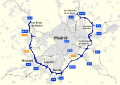
- Madrid, Spain – M-30 (inner city), M-40 (inner metropolitan region), M-50 (outer metropolitan region, incomplete)
- Malmö, Sweden – Inre ringvägen (inner city), E6 & E20 (outer city city)
- Manchester, England – Manchester Inner Ring Road (inner city), M60 motorway (metropolitan region)
- Milan, Italy – Autostrada A4, Autostrada A50 (West), Autostrada A51 (East), Autostrada A52 (North) and Autostrada A58 (Outer Eastern) bypass roads (it is the largest system of ring roads around a city in Italy, for a total length greater than 100 kilometres (62 mi)[1]), Circolare Esterna (periphery ring road), Circonvallazione (ring road around the centre), Cerchia Interna (ring road in the city centre)
- Minsk, Belarus – M9
- Moscow, Russia – Boulevard Ring, Garden Ring, Third Ring Road, Moscow Ring Road (opened in 1961)
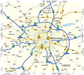
- Munich, Germany – Altstadtring (inner city), Bundesstraße 2 R (middle ring), Bundesautobahn 99 (inner metropolitan region)
- Naples, Italy – Tangenziale di Napoli
- Oslo, Norway – Ring 1 [nb] (city centre), Ring 2 (middle ring) and Ring 3 (city proper)
- Oxford, England – Oxford Ring Road
- Paris, France – Boulevard Périphérique (city proper), A86 autoroute (inner metropolitan region), Francilienne (tertiary ring road), Grand contournement de Paris (metropolitan region)
- Padua, Italy – GRAP
- Palma de Mallorca, Spain – Ma-20 (Vía de Cintura)
- Prague, Czech Republic – outer – D0 and inner Městský okruh
- Poznań, Poland – outer ring: expressway S11, motorway A2 (concurrent with S5 and S11), expressway S5; inner rings: 1st – partially completed, 2nd – completed, partially concurrent with national road 92 and voivodeship roads 196 and 433, 3rd – planned
- Reggio Calabria, Italy – Tangenziale di Reggio Calabria
- Rennes, France – Rocade de Rennes
- Rome, Italy – Grande Raccordo Anulare
- Sofia, Bulgaria – Sofia Ring Road
- Saint Petersburg, Russia – Saint Petersburg Ring Road
- Stockholm, Sweden – Nörra Länken, Essingeleden, Södra Länken (city proper) and E20 (outer city, under completion).
- Skopje, North Macedonia – A2 motorway (North Macedonia) (part of E65)
- Tampere, Finland – Tampere Ring Road
- Toulouse, France – Périphérique de Toulouse
- Thessaloniki, Greece – Thessaloniki Inner Ring Road
- Turin, Italy – Tangenziale di Torino
- Venice, Italy – Tangenziale di Venezia
- Vienna, Austria – Vienna Ring Road (inner city), Vienna Beltway (outer districts)
- Vigo, Spain – VG-20 (Vigo Ring Road)
- Warsaw, Poland – Expressway S2, Expressway S7, Expressway S8, Expressway S17 (planned stretch)
- Wrocław, Poland – Outer ring: Autostrada A4, Autostrada A8, Expressway S8, Wroclaw Eastern Bypass (in construction). Inner ring: National road 5, National road 94
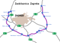
- Zagreb, Croatia – Zagreb bypass
- Zillina, Slovakia – I/60 [sk] Mestky okruch
In Iceland, there is a 1,332 km ring road, called the ring road (or Route 1), around most of the island (excluding only the remote Westfjords). Most of the country's settlements are on or near this road.
Some maps of ring roads in Europe
[edit]-
 Antwerp, Belgium
 -
 Berlin, Germany
 -
 Bologna, Italy
 -
 Bordeaux, France
 -
 Brussels, Belgium
 -
 Bucharest, Romania
 -
 Budapest, Hungary
 -
 Caen, France
 -
 Catania, Italy
 -
 Charleroi, Belgium
 -
 Cologne, Germany
 -
 Dublin, Ireland
 -
 Kyiv, Ukraine
 -
 Ljubljana, Slovenia
 -
 Lyon, France
 -
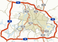
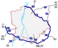
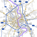
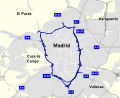 Madrid, Spain (Inner city)
 -
 Madrid, Spain (Inner metropolitan region)
 -
 Madrid, Spain
 -
 Milan, Italy
 -
 Moscow, Russia
 -
 Munich, Germany
 -
 Paris, France
 -
 Rome, Italy
 -
 Sofia, Bulgaria
 -
 Toulouse, France
 -
 Turin, Italy
 -
 Venice, Italy
 -
 Zagreb, Croatia
.svg)


.svg)

.png)


.png)


Asia-Pacific
[edit]
Major cities that are served by a ring road or ring road system:
- Australia: Sydney (Sydney Orbital Network), Canberra, Adelaide, Brisbane, Perth and Melbourne have ring roads.
- Afghanistan, Ring Road, a 2200 km long road circulating inside the country, and connects most of Afghanistan's major cities, such as Kabul, Ghazni, Kandahar, Herat and Mazar-i-Sharif.
- Ahmedabad, India – Sardar Patel Ring Road
- Ankara, Turkey – Otoyol 20
- Bandung, Indonesia – Padaleunyi Toll Road, Soekarno-Hatta Road
- Bangkok, Thailand – Ratchadaphisek Road (Inner Ring Road) and Kanchanaphisek Road (Outer Ring Road)
- Beijing, China – ring roads encircling the city.[12]: 135
- Bengaluru, India - Outer Ring Road. The Peripheral Ring Road and Satellite Town Ring Road are upcoming ring roads around Bengaluru.
- Chiang Mai, Thailand – Chiang Mai Outer Ring Road (National Highway 121)
- Christchurch, New Zealand – Christchurch Ring Road includes parts of State Highways 1, 74, and 76. The "Four Avenues" (Bealey Avenue, Fitzgerald Avenue, Moorhouse Avenue, and Deans Avenue) serve as an inner ring around the central city.
- Delhi, India – Inner Ring Road, Delhi, Outer Ring Road, Delhi, and the Peripheral Expressway consisting of two halves, the Western Peripheral Expressway and the Eastern Peripheral Expressway.
- Erbil, Iraq – Four ring roads circulating through/around the city.
- Fukuoka, Japan – Fukuoka Expressway Circular Route
- George Town, Malaysia – George Town Inner Ring Road, Penang Middle Ring Road
- Hanoi, Vietnam – Ringway 3
- Ho Chi Minh City, Vietnam – Ringway 3
- Hawaii Island, Hawaii – Hawaii Belt Road
- Hong Kong, Hong Kong – Route 9 (New Territories Circular Road)
- Hyderabad, India – Outer Ring Road, Hyderabad
- Jakarta, Indonesia – Jakarta Inner Ring Road, Jakarta Outer Ring Road, Jakarta Outer Ring Road 2
- Kalaburagi, India – Kalaburagi Ring Road
- Kathmandu, Nepal – Kathmandu Ringroad
- Kuala Lumpur, Malaysia – Kuala Lumpur Inner Ring Road, Kuala Lumpur Middle Ring Road 1, Kuala Lumpur Middle Ring Road 2, Kuala Lumpur Outer Ring Road
- Lahore, Pakistan – Lahore Ring Road
- Manila, Philippines – Circumferential Road 1, Circumferential Road 2, Circumferential Road 3, EDSA, Circumferential Road 5, Circumferential Road 6
- Medina, Saudi Arabia – King Faisal Road (1st Ring Road) and King Abdullah Road (2nd Ring Road)
- Mysuru, India – Outer Ring Road
- Nagoya, Japan – C1 Inner Ring Route Expressway, C2 Second Ring Route Expressway, C3 Third Ring Route Expressway, Japan National Route 302, Nagoya Municipal Road Nagoya Inner Ring
- Nakhon Ratchasima, Thailand – Nakhon Ratchasima Ring Route (National Highway 290)
- Nagpur, Maharashtra, India - Inner Ring Road, Outer Ring Road
- Osaka, Japan – Loop Route
- Peshawar, Pakistan – Peshawar Ring Road
- Ranchi, India – Ranchi Ring Road
- Rawalpindi/Islamabad, Pakistan = Rawalpindi Ring Road (under construction)
- Riyadh, Saudi Arabia – Riyadh Ring Road
- Sendai, Japan – Gurutto Sendai
- Seoul, South Korea – Capital Region First Ring Expressway
- Shanghai, China – Inner Ring Road, Middle Ring Road, S20 Outer Ring Expressway, G1501 Shanghai Ring Expressway
- Singapore, Singapore – Outer Ring Road System
- Suphan Buri, Thailand – Suphan Buri Ring Route (National Hightway 357)
- Tianjin, China – Inner, Middle and Outer Ring Roads
- Tokyo, Japan – C1 Inner Circular Expressway, C2 Central Circular Expressway, C3 Gaikan Expressway, C4 Ken-Ō Expressway, CA Tokyo Bay Aqua-Line/B Bayshore Route, Yokohama Ring Expressway, Japan National Route 16, Japan National Route 298, Japan National Route 357, Japan National Route 468
Africa
[edit]- Addis Ababa, Ethiopia – Addis Ababa Ring Road
- Bloemfontein, South Africa – Bloemfontein Ring Road
- Cairo, Egypt – Ring Road (Cairo)
- Durban, South Africa – Durban Outer Ring Road
- Johannesburg, South Africa – Johannesburg Ring Road
- Polokwane, South Africa – Polokwane Ring Road
- Pretoria, South Africa – Pretoria Ring Road
See also
[edit]- Circumferential Highway
- Downtown circulator
- Link road
- List of ring roads
- Circle route, a public transport route forming a circle
References
[edit]- ^ a b "7 cose che forse non sapevi delle TANGENZIALI di Milano" (in Italian). Retrieved 13 June 2024.
- ^ Snell, Steven (7 November 2013). "The Irony of Ring Roads". Planetizen. Archived from the original on 11 November 2020. Retrieved 7 February 2021.
- ^ "Are these the worst ring roads in England?". BBC News. 5 April 2014. Archived from the original on 11 November 2020. Retrieved 7 February 2021.
- ^ "State Highway, Loop, and Spur Facts". www.dot.state.tx.us. Retrieved 31 May 2023.
- ^ "Big Island State Roads and Highways". hidot.hawaii.gov. Archived from the original on 26 December 2021. Retrieved 10 August 2022.
- ^ "Inner Ring Road". Connect2Edmonton. Archived from the original on 14 July 2014. Retrieved 12 July 2014.
- ^ "Northeast Anthony Henday Drive". www.northeastanthonyhenday.com. Archived from the original on 31 July 2018. Retrieved 15 September 2016.
- ^ "Northeast Anthony Henday Drive". Alberta Transportation. 2016. Archived from the original on 12 October 2016. Retrieved 2 October 2016.
The northeast leg of Anthony Henday Drive opened on October 1, 2016, after five years of construction...
- ^ "Length of Stoney Trail" (Map). Google Maps. Retrieved 1 December 2016.
- ^ Malathronas, John (24 April 2015). "Vienna's Ringstrasse celebrates 150 years". edition.cnn.com. CNN. Archived from the original on 31 December 2016. Retrieved 15 September 2016.
- ^ "Historic Centre of Vienna". whc.unesco.org. UNESCO World Heritage Centre. Archived from the original on 2 November 2011. Retrieved 15 September 2016.
- ^ Hu, Richard (2023). Reinventing the Chinese City. New York: Columbia University Press. ISBN 978-0-231-21101-7.
| International | |
|---|---|
| National | |
| Other | |
Ring road
View on GrokipediaDefinition and Purpose
Terminology and Variations
A ring road is a roadway or series of connected roadways designed to encircle an urban area, primarily to divert through-traffic from the city center and mitigate congestion within it.[6] Common synonymous terms include beltway, particularly in the United States where it often denotes a circumferential highway around major metropolitan areas like Washington, D.C.; orbital motorway, favored in contexts emphasizing complete encirclement such as in the United Kingdom; and circumferential highway or loop, which highlight the looping geometry.[7][8] Terminology varies regionally and by engineering context: in American usage, "beltway" evokes a defensive or encircling connotation derived from military analogies, while "ring road" predominates in British English for roads skirting town peripheries.[9] In continental Europe, equivalents like "tangenziale" in Italy or "périphérique" in France denote urban bypass loops, often integrated into motorway networks.[10] Distinctions from related concepts are precise: unlike a bypass, which diverts traffic around a specific built-up zone or obstacle along a linear route, a ring road forms a closed or near-closed loop around an entire urban core.[11] Variations in ring road configurations include full circles, which achieve complete encirclement for optimal traffic diversion, versus partial or horseshoe shapes that connect radial routes but leave gaps, as seen in irregularly shaped metropolitan implementations.[12] Concentric systems feature multiple nested rings, such as an inner ring hugging the urban core and outer rings on suburban peripheries, enabling hierarchical traffic management; for instance, outer rings typically span wider expanses with fewer intersections to handle higher-speed interurban flows.[13] These adaptations reflect urban planning priorities, with full orbitals prioritizing seamless bypasses and partial variants accommodating terrain constraints or phased construction.[4]Core Functions and Objectives
Ring roads serve as circumferential highways encircling urban areas, with their primary objective being to intercept and redirect through-traffic—vehicles not destined for the city center—away from congested radial arterials, thereby reducing bottlenecks in the core.[1] [14] This diversion function stems from the recognition that central districts often lack capacity for high-volume inter-regional flows, allowing ring roads to act as collectors for suburban-to-suburban or bypass movements.[15] By channeling such traffic onto dedicated, limited-access alignments, they minimize disruptions to local circulation, enabling inner roads to handle short-trip access more efficiently.[4] A key engineering objective is to enhance overall network efficiency through grade-separated interchanges and high-speed design standards, typically supporting speeds of 80–120 km/h, which facilitate rapid traversal of metropolitan peripheries without the interruptions of at-grade urban intersections.[1] This supports modal separation, where freight and long-haul vehicles avoid residential zones, potentially lowering accident rates by isolating high-speed flows from pedestrians and slower local traffic.[16] In integrated systems, ring roads interconnect with radial expressways to form hierarchical grids, optimizing connectivity for logistics and commuter patterns while distributing load across the urban fringe.[14] Beyond immediate traffic management, ring roads pursue spatial and economic objectives by shaping urban form: they encourage decentralized development along their corridors, fostering exurban growth nodes such as industrial parks and retail hubs that leverage improved peripheral access.[14] [4] This aligns with planning goals to balance centripetal forces of agglomeration with centrifugal pressures from sprawl, though empirical studies indicate that while initial congestion relief is achievable—e.g., up to 10–20% volume reduction on inner radials in early post-construction phases—sustained benefits depend on complementary measures like demand management to counter induced traffic growth.[16] [14]Historical Development
Pre-20th Century Precursors
The earliest precursors to modern ring roads emerged in Europe during the 18th and 19th centuries, when expanding urban centers prompted the demolition of medieval defensive walls and their replacement with wide boulevards designed to facilitate circumferential traffic flow and reduce congestion in historic cores. These structures diverged from purely defensive enclosures by prioritizing vehicular and pedestrian circulation, often for horse-drawn carriages and commerce, laying conceptual groundwork for later orbital routes.[17][18] In Vienna, the Ringstrasse exemplifies this transition: following the 1850 demolition of 13th-century fortifications under Emperor Franz Joseph I, construction of the 5.3-kilometer (3.3-mile) boulevard began in 1858 and spanned over three decades until 1888, encircling the Innere Stadt with a horseshoe-shaped path lined by monumental public buildings. Intended to symbolize imperial grandeur while enabling efficient movement around the city center, it incorporated broad lanes for traffic that bypassed narrow medieval streets, marking one of the first deliberate urban planning efforts to integrate ring-like infrastructure for mobility.[19][18][17] London's New Road, authorized by Parliament in 1756 and opened progressively through the late 18th century, formed a northern arc spanning approximately 4 miles (6.4 km) from Paddington to Islington, traversing open fields to divert long-distance coach traffic away from the overcrowded City of London. As Britain's inaugural purpose-built toll bypass, it connected radial routes like the Oxford and Holyhead roads, allowing through-traffic to skirt the central districts without entering them, though it did not fully close into a loop until later extensions in the 19th century. This innovation addressed growing commercial demands amid industrialization, predating motorized vehicles but anticipating ring road functions in decongesting cores. Paris provided another model through its Grands Boulevards, developed from the 1670s onward after Louis XIV ordered the razing of 14th-century walls; these were widened and unified under Baron Haussmann's renovations between 1853 and 1870 into a network of broad avenues totaling over 100 kilometers (62 miles) that partially encircled the historic center. While primarily aesthetic and crowd-control oriented—facilitating military maneuvers and promenades—the boulevards' radial and tangential alignments enabled alternative routing for carriages, mitigating bottlenecks in winding intra-muros streets and influencing subsequent outer circuits like the 19th-century military boulevards tracing earlier fortifications.[20][21] Such developments reflected causal pressures from population growth and economic activity, transforming static barriers into dynamic transport arteries without the high-speed engineering of 20th-century highways.[20]Mid-20th Century Emergence
The mid-20th century marked the widespread emergence of modern ring roads, driven by post-World War II surges in automobile ownership and suburban expansion, which exacerbated urban traffic congestion. In the United States, formal planning for circumferential highways, or beltways, accelerated in the early 1950s as part of broader efforts to modernize transportation infrastructure amid rapid motorization. The Federal-Aid Highway Act of 1956 formalized the Interstate Highway System, incorporating urban loops to encircle major cities and divert through-traffic from central districts, with over 2,300 miles of such routes open by 1961.[22] A seminal example was the Capital Beltway (I-495) around Washington, D.C., where planning commenced in 1950 and construction aligned with the interstate program, culminating in its full opening on August 17, 1964.[23] [24] This 66-mile loop exemplified the design intent to integrate radial interstates with orbital paths, facilitating commuter access to suburbs while theoretically alleviating downtown bottlenecks.[25] In Europe, similar initiatives arose during post-war reconstruction, with Antwerp's ring road concept originating in 1949 and initial segments completed in the late 1950s, fully operational by 1978.[26] Italy's Grande Raccordo Anulare (GRA) in Rome is noted as one of the earliest complete ring roads in a major European city post-WWII, emphasizing controlled-access features to handle growing vehicular volumes.[27] These developments reflected a causal shift toward hierarchical road networks, prioritizing high-capacity bypasses to sustain economic mobility, though empirical data from the era underscored planning optimism over long-term congestion forecasts.[1] By the 1960s, ring roads proliferated globally as standard urban planning tools, influenced by U.S. interstate models and local adaptations to automobile-dependent growth.[28]Global Expansion Post-1960s
![M25 motorway, London][float-right] The post-1960s era witnessed accelerated construction of ring roads worldwide, as rising vehicle ownership and urban sprawl necessitated circumferential infrastructure to divert through-traffic from city centers. In North America, the U.S. Interstate Highway System facilitated multiple beltways, exemplified by the Capital Beltway (I-495) around Washington, D.C., which achieved substantial completion by 1964, spanning 64 miles and initially easing radial congestion through grade-separated design. Similar projects, such as Cincinnati's I-275 opened in segments from 1962 to 1975, extended this model, prioritizing high-capacity freeway standards to accommodate inter-suburban flows.[29] In Western Europe, ring roads proliferated amid post-war reconstruction and motorization booms. Paris's Boulevard Périphérique, initiated in 1956 but fully operational by its 1973 inauguration, formed a 35-kilometer urban loop, rapidly becoming overloaded with over 1.2 million daily vehicles by the late 20th century despite its bypass intent. The United Kingdom's M25 London Orbital Motorway, built from 1975 to 1986 and opened on October 29, 1986, by Prime Minister Margaret Thatcher, encircled Greater London over 117 miles, initially hailed for linking radial motorways but soon critiqued for inducing demand exceeding projections. Other examples include Belgium's R0 Brussels ring road, completed in phases through the 1970s, and Germany's A10 Berliner Ring, expanded post-reunification in the 1990s to handle reunified traffic volumes.[30][31] Asia's expansion lagged initially but surged with economic liberalization. In Japan, Tokyo's Gaikan Expressway (outer ring) sections opened progressively from 1962, achieving fuller connectivity by the 1980s to mitigate central district overload. China's Beijing ring roads exemplified rapid scaling: the Second Ring Road completed in 1981, Third in 1993, and Fourth in 2001, each successive loop—often elevated or expressway-grade—accommodating explosive growth in private vehicles from fewer than 1 million nationwide in 1990 to over 200 million by 2019, though contributing to peripheral sprawl. In India, projects like Ahmedabad's Sardar Patel Ring Road, operational from 2013 after planning in the 2000s, reflected adapting Western models to denser contexts.[32] This global diffusion, influenced by U.S. engineering precedents, saw over 500 urban ring roads operational by the early 21st century, per infrastructure analyses, though empirical outcomes varied: while providing initial relief, many faced chronic congestion due to underestimated induced traffic, as observed in empirical studies of arterial bypass efficacy. In Eastern Europe and developing regions, post-1990s privatizations and foreign aid spurred builds, such as Moscow's expanded MKAD in the 2000s and Ukraine's Kyiv inner ring upgrades.[1]Design Principles and Engineering
Geometric and Structural Features
Ring roads are designed with horizontal alignments that form closed loops, often polygonal to adapt to terrain and existing infrastructure, enabling vehicles to circumnavigate urban cores without entering them. The curvature of these alignments incorporates minimum radii based on design speed and superelevation rates to ensure safe vehicle handling; for instance, under AASHTO standards for freeways with design speeds of 100-110 km/h (60-70 mph), minimum radii range from 400-700 meters assuming 6-8% superelevation.[33] Vertical geometry limits grades to 3-4% maximum for sustained sections to maintain traffic flow, with sight distances exceeding 200 meters for passing and stopping.[34] Cross-sections typically feature 2-4 lanes per direction, each 3.6-3.7 meters wide, separated by a median barrier of at least 1.2 meters, plus emergency shoulders of 3-4 meters to accommodate breakdowns and maintenance without disrupting mainline traffic.[34] In urban settings, these elements prioritize capacity and safety, with superelevation transitions designed to avoid abrupt changes that could cause instability at high speeds. Structurally, ring roads employ grade-separated interchanges—such as cloverleaf, turbine, or single-point urban interchanges (SPUI)—to connect with radial routes, minimizing weaving conflicts and ensuring continuous flow; spacing between interchanges often exceeds 1-2 km to allow adequate merge/diverge distances of 300-600 meters.[35] Elevated viaducts, constructed from prestressed concrete girders spanning 30-50 meters, and underpasses facilitate crossings over railroads, rivers, or dense development, while embankments use compacted earth or geosynthetics for stability.[36] Pavements consist of multi-layer asphalt or continuously reinforced concrete, engineered for heavy traffic volumes exceeding 100,000 vehicles daily, with durable surfacing to resist rutting and cracking.[37]| Design Element | Typical Specification for Urban Ring Roads |
|---|---|
| Lane Width | 3.6 m (12 ft) per lane[34] |
| Shoulder Width | 3-3.7 m (10-12 ft) inside/outside[34] |
| Minimum Curve Radius (100 km/h, 7% e) | ~550 m[33] |
| Max Grade | 3-4% sustained[34] |
| Interchange Spacing | 1-3 km, with 400-800 m weave lanes[35] |