
Community hub
Recent from talks
Contribute something
Nothing was collected or created yet.
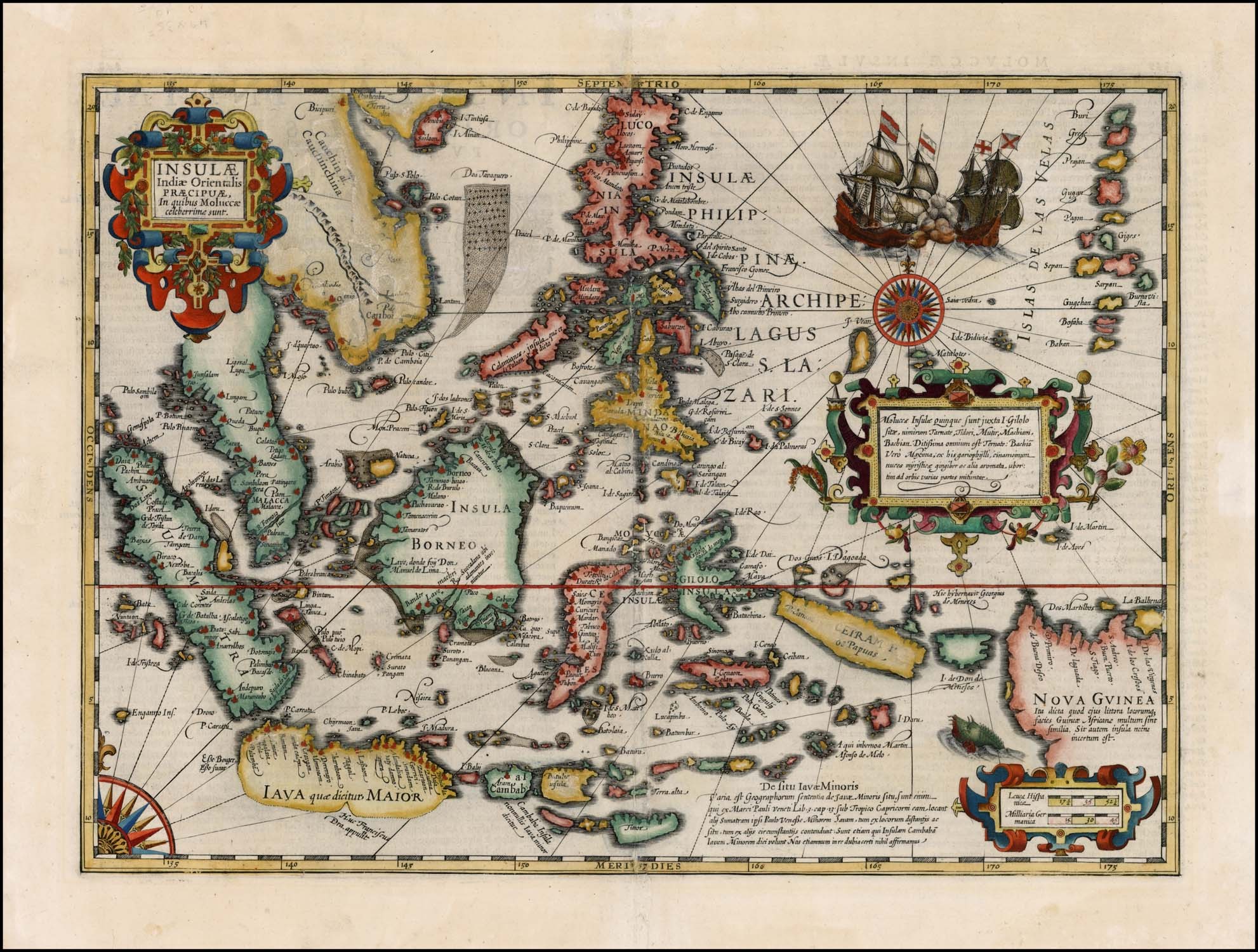
East Indies
View on Wikipedia
_-_Geographicus_-_EastIndies-cary-1801.jpg)

The East Indies (or simply the Indies) is a term used in historical narratives of the Age of Discovery. The Indies broadly referred to various lands in the East or the Eastern Hemisphere, particularly the islands and mainlands found in and around the Indian Ocean by Portuguese explorers, soon after the Cape Route was discovered. In a narrow sense, the term was used to refer to the Malay Archipelago, which today comprises the Philippine Archipelago, Indonesian Archipelago, Borneo, and New Guinea. Historically, the term was used in the Age of Discovery to refer to the coasts of the landmasses comprising the Indian subcontinent and the Indochinese Peninsula along with the Malay Archipelago.[1][2][3]
Overview
[edit]During the era of European colonization, territories of the Spanish Empire in Asia were known as the Spanish East Indies for 333 years before the American conquest and later the independence of the Philippines. Dutch occupied colonies in the area were known for about 300 years as the Dutch East Indies until Indonesian independence. The East Indies may also include the former French Indochina, former British territories Brunei, Hong Kong and Singapore and former Portuguese Macau and Timor. It does not, however, include the former Dutch New Guinea, which is geographically considered to be part of Melanesia.
The inhabitants of the East Indies are never called East Indians, as they are not linguistically related to South Asia, most specifically the Indo-Aryan languages. It distinguishes them both from inhabitants of the Caribbean (which is also called the West Indies) and from the indigenous peoples of the Americas who are often called American Indians. However, in colonial times, the non-Indian Southeast Asians were also called "Indians".
Peoples of the East Indies comprise a wide variety of cultural diversity, and the inhabitants do not consider themselves as belonging to a single ethnic group. The region is mostly populated by the Austronesians, who first expanded from the island of Taiwan, and later on during the early modern period, when East Asians such as the Han Chinese started to migrate south and became known as the Peranakans or Straits Chinese.
Buddhism, Christianity, Islam and Hinduism are the most popular religions throughout the region, while Sikhism, Jainism, Chinese folk religion and various other traditional beliefs and practices are also prominent in some areas. The major languages in this area draw from a wide variety of language families such as the Austronesian and Sino-Tibetan languages, and should not be confused with the term Indo-Aryan, a group of languages spoken in the Indian subcontinent. Speakers of Austroasiatic, Tai–Kadai, and Hmong–Mien languages also live in the region.
Regions of the East Indies are sometimes known by the colonial empire they once belonged to, hence, Spanish East Indies means the Philippines, Dutch East Indies means Indonesia, and British East Indies refers to Malaysia.
Historically, the king of Abyssinia (modern Ethiopia) was identified with "Prester John of the Indies", since that part of the world was imagined to be one of "Three Indias".
History
[edit]
Exploration of the East Indies by European powers began in the last three years of the 15th century and continued into the 16th century, led by the Portuguese explorers.[4] The Portuguese described the entire region they discovered as the Indies. Eventually, the region would be broken up into a series of Indies: The East Indies, which was also called "Old Indies" or "Great Indies", consisting of India, and the West Indies, also called "New Indies" or "Little Indies", consisting of the Americas.[5]
These regions were important sources of trading goods, particularly cotton, indigo and spices after the establishment of European trading companies: the British East India Company and Dutch East India Company, among others, in the 17th century.
The New World was initially thought to be the easternmost part of the Indies by explorer Christopher Columbus, who had grossly underestimated the westerly distance from Europe to Asia. Later, to avoid confusion, the New World came to be called the "West Indies", while the original Indies came to be called the "East Indies".
The designation East Indian was once primarily used to describe people of all of the East Indies, in order to avoid the potential confusion from the term American Indian who were once simply referred to as Indians (see the Native American name controversy for more information).
See also
[edit]- Spanish East Indies
- Dutch East Indies
- Insulindia
- Portuguese East Indies
- French Indochina
- List of governors-general of the Philippines
- Global Southeast, largely coterminous with historic meaning of East Indies
- Greater Philippines
- Straits Settlements
- Malayness
- Malay world
- Malay Archipelago
- Malay race
- Maphilindo
- Maritime Southeast Asia
- Nusantara
- Greater Indonesia
- History of the Americas
References
[edit]- ^ "A map of the East-Indies and the adjacent countries, with the settlements, factories and territories, explaning [sic] what belongs to England, Spain, France, Holland, Denmark, Portugal & c with many remarks not extant in any other map". 1720.
- ^ "East Indies | islands, Southeast Asia | Britannica".
- ^ "East Indies | Encyclopedia.com". www.encyclopedia.com.
- ^ "The Present State of the West-Indies: Containing an Accurate Description of What Parts Are Possessed by the Several Powers in Europe". World Digital Library. 1778. Retrieved 2013-08-30.
- ^ Kitchin, Thomas (1778). The Present State of the West-Indies: Containing an Accurate Description of What Parts Are Possessed by the Several Powers in Europe. London: R. Baldwin. p. 3.
East Indies
View on GrokipediaThis vast archipelago, spanning over 3,000 islands and lying between the Asian mainland and Australia, became a focal point of global commerce due to its abundant natural resources, especially spices such as cloves, nutmeg, and pepper originating from the Moluccas, known as the Spice Islands.[3][4]
European exploration intensified in the late 15th century, with Portuguese navigators like Vasco da Gama seeking direct sea routes to bypass Middle Eastern intermediaries, leading to the establishment of trading posts and eventual colonial footholds by Portugal, Spain, Britain, and the Netherlands.[5][6]
The Dutch East India Company (VOC), chartered in 1602, achieved dominance in the region by securing monopolies on key spices through military means and fortified settlements, culminating in the founding of Batavia in 1619 as the administrative center of the Dutch East Indies, which persisted as a colony until Indonesia's declaration of independence in 1945.[7][8][9]
The East Indies' colonial era facilitated the transfer of wealth to Europe via extractive enterprises, including the cultuurstelsel system of mandatory crop cultivation from 1830 to 1870, which generated substantial revenues but imposed heavy labor demands on indigenous populations, shaping the region's economic and political trajectory toward post-colonial nation-states.[8][10]