

Community hub
Recent from talks
Contribute something
Nothing was collected or created yet.
Geography of China
View on Wikipedia
Key Information


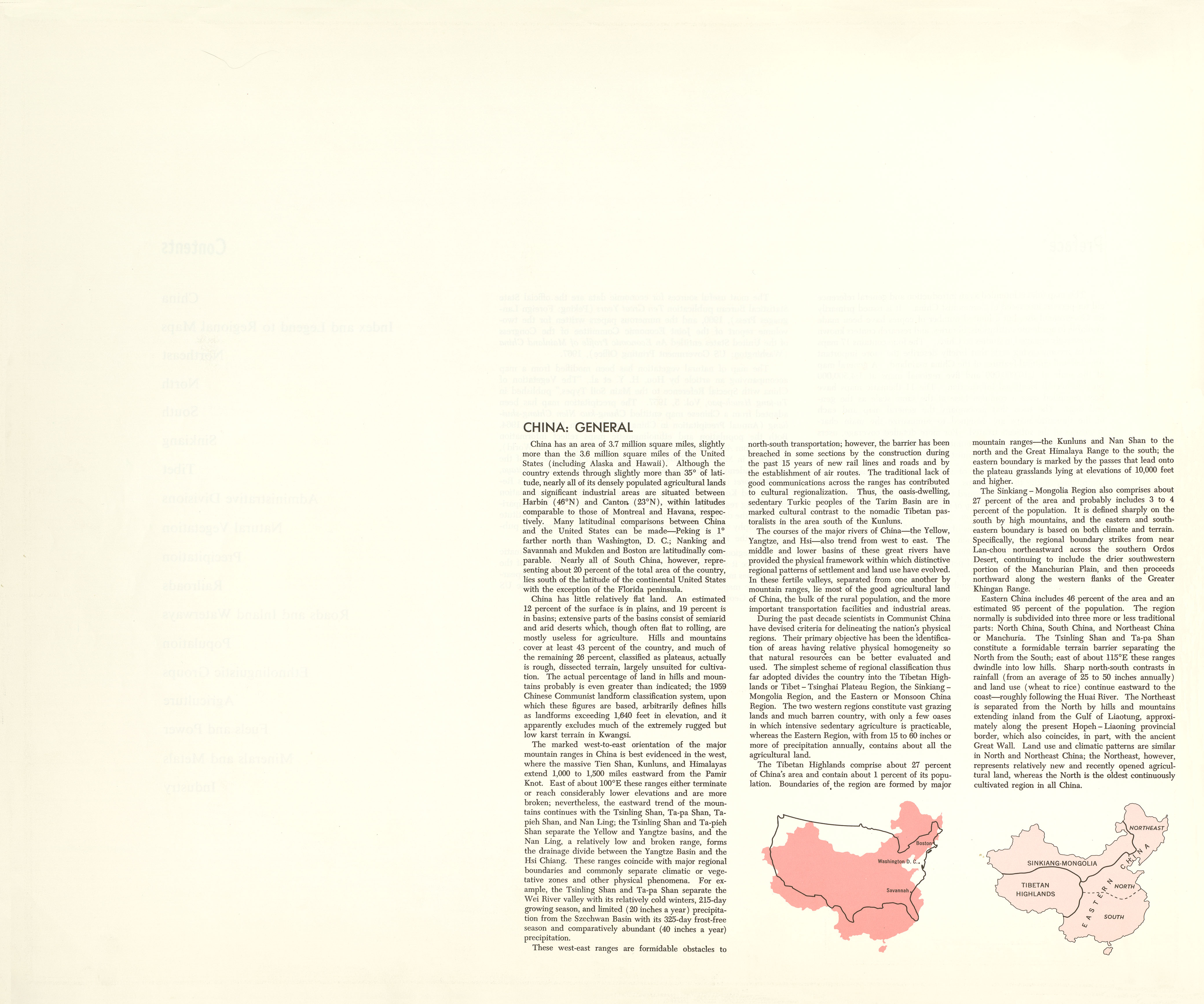
China has great physical diversity. The eastern plain and southern coasts of the country consist of fertile lowlands and foothills. They are the location of most of China's agricultural output and human population. The southern areas of the country (south of the Yangtze River) consist of hilly and mountainous terrain. The west and north of the country are dominated by sunken basins (such as the Gobi and the Taklamakan), rolling plateaus, and towering massifs. It contains part of the highest tableland on earth, the Tibetan Plateau, and has much lower agricultural potential and population.
Traditionally, the Chinese population centered on the Chinese Central Plain, developing as a country whose center lay in the middle and lower reaches of the Yellow River on the northern plains.[4] More recently, the 18,000 km (11,000 mi) coastline has been used extensively for export-oriented trade, causing the coastal provinces to become the leading economic center.
The People's Republic of China has an area of about 9,600,000 km2 (3,700,000 sq mi). The exact land area is sometimes challenged by border disputes, most notably about Taiwan, Aksai Chin, the Trans-Karakoram Tract, and South Tibet. The area of the People's Republic of China is 9,596,960 km2 (3,705,410 sq mi) according to the CIA's The World Factbook.[1] The People's Republic of China is either the third or fourth-largest country in the world, being either slightly larger or slightly smaller than the United States, depending on how the area of the United States is measured. Both countries are smaller than Russia and Canada and larger than Brazil.


Physical geography
[edit]Generalities
[edit]
The topography of China has been divided by the Chinese government into five homogeneous physical macro-regions, namely Eastern China (subdivided into the northeast plain, north plain, and southern hills), Xinjiang-Mongolia, and the Tibetan highlands.[5] It is diverse with snow-capped mountains, deep river valleys, broad basins, high plateaus, rolling plains, terraced hills, sandy dunes with many other geographic features and other landforms present in myriad variations. In general, the land is high in the west and descends to the east coast. Mountains (33 percent), plateaus (26 percent), and hills (10 percent) account for nearly 70 percent of the country's land surface. Most of the country's arable land and population are based in lowland plains (12 percent) and basins (19 percent), though some of the greatest basins are filled with deserts. The country's rugged terrain presents problems for the construction of overland transportation infrastructure and requires extensive terracing to sustain agriculture, but is conducive to the development of forestry, mineral and hydropower resources, as well as tourism in the country.
Eastern China
[edit]- Northeast Plain
Northeast of Shanhaiguan a narrow sliver of flat coastal land opens up into the vast Northeast China Plain. The plains extend north to the crown of the "Chinese rooster", near where the Greater and Lesser Hinggan ranges converge. The Changbai Mountains to the east divide China from the Korean peninsula.
- North plain
The Taihang Mountains form the western side of the triangular North China Plain. The other two sides are the Pacific coast to the east and the Yangtze River to the southwest. The vertices of this triangle are Beijing to the north, Shanghai to the southeast, and Yichang to the southwest. This alluvial plain, fed by the Yellow and Yangtze Rivers, is one of the most heavily populated regions of China. The only mountains in the plain are the Taishan in Shandong and Dabie Mountains of Anhui.
Beijing, at the north tip of the North China Plain, is shielded by the intersection of the Taihang and Yan Mountains. Further north are the drier grasslands of the Inner Mongolian Plateau, traditionally home to pastoralists. To the south are agricultural regions, traditionally home to sedentary populations. The Great Wall of China was built across the mountains that mark the southern edge of the Inner Mongolian Plateau. The Ming-era walls run over 2,000 km (1,200 mi) east to west from Shanhaiguan on the Bohai coast to the Hexi Corridor in Gansu.
- South (hills)


East of the Tibetan Plateau, deeply folded mountains fan out toward the Sichuan Basin, which is ringed by mountains with 1,000–3,000 m elevation. The floor of the basin has an average elevation of 500 m and is home to one of the most densely farmed and populated regions of China. The Sichuan Basin is capped in the north by the eastward continuation of the Kunlun range, the Qinling, and the Dabashan. The Qinling and Dabashan ranges form a major north–south divide across China Proper, the traditional core area of China. Southeast of the Tibetan Plateau and south of the Sichuan Basin is the Yunnan-Guizhou Plateau, which occupies much of southwest China. This plateau, with an average elevation of 2,000 m, is known for its limestone karst landscape.
South of the Yangtze, the landscape is more rugged. Like Shanxi Province to the north, Hunan and Jiangxi each have a provincial core in a river basin that is surrounded by mountains. The Wuling range separates Guizhou from Hunan. The Luoxiao and Jinggang divide Hunan from Jiangxi, which is separated from Fujian by the Wuyi Mountains. The southeast coastal provinces, Zhejiang, Fujian and Guangdong, have rugged coasts, with pockets of lowland and mountainous interior. The Nanling, an east–west mountain range across northern Guangdong, seals off Hunan and Jiangxi from Guangdong.
Xinjiang-Mongolia
[edit]Northwest of the Tibetan Plateau, between the northern slope of Kunlun and southern slope of Tian Shan, is the vast Tarim Basin of Xinjiang, which contains the Taklamakan Desert. The Tarim Basin, the largest in China, measures 1,500 km (930 mi) from east to west and 600 km (370 mi) from north to south at its widest parts. Average elevation in the basin is 1,000 m. To the east, the basin descends into the Hami-Turpan Depression of eastern Xinjiang, where the dried lake bed of Lake Ayding, at −154m below sea level, is the lowest surface point in China and the third-lowest in the world. With temperatures that have reached 49.6 C., the lake bed ranks as one of the hottest places in China. North of Tian Shan is Xinjiang's second great basin, the Junggar, which contains the Gurbantünggüt Desert. The Junggar Basin is enclosed to the north by the Altay Mountains, which separate Xinjiang from Russia and Mongolia.
Northeast of the Tibetan Plateau, the Altun Shan-Qilian Mountains range branches off the Kunlun and creates a parallel mountain range running east–west. In between in northern Qinghai is the Qaidam Basin, with elevations of 2,600–3,000 m and numerous brackish and salt lakes. North of the Qilian is Hexi Corridor of Gansu, a natural passage between Xinjiang and China Proper that was part of the ancient Silk Road and traversed by modern highway and rail lines to Xinjiang. Further north, the Inner Mongolian Plateau, between 900 and 1,500 m in elevation, arcs north up the spine of China and becomes the Greater Hinggan Range of Northeast China.
Between the Qinling and the Inner Mongolian Plateau is Loess Plateau, the largest of its kind in the world, covering 650,000 km2 (250,000 sq mi) in Shaanxi, parts of Gansu and Shanxi provinces, and some of Ningxia-Hui Autonomous Region. The plateau is 1,000–1,500m in elevation and is filled with loess, a yellowish, loose soil that travels easily in the wind. Eroded loess silt gives the Yellow River its color and name. The Loess Plateau is bound to the east by the Luliang Mountain of Shanxi, which has a narrow basin running north to south along the Fen River. Further east are the Taihang Mountains of Hebei, the dominant topographical feature of North China.


- Highlands
The world's tallest mountains, the Karakorum, Pamirs and Tian Shan divide China from South and Central Asia. Eleven of the seventeen tallest mountain peaks on Earth are located on China's western borders. They include the world's tallest peak Mount Everest (8848 m) in the Himalayas on the border with Nepal and the world's second tallest peak, K2 (8611 m) on the border with Pakistan. From these towering heights in the west, the land descends in steps like a terrace.
North of the Himalayas and east of the Karakorum/Pamirs is the vast Tibetan Plateau. It is the largest and highest plateau in the world, and for this reason is also informally known as the "Roof of the World". Its average elevation is 4000 meters above sea level. Its area is 2.5 million square kilometers which is just over a quarter of China's total area. In the north, the plateau is hemmed in by the Kunlun Mountains, which extends eastward from the intersection of the Pamirs, Karakorum and Tian Shan.
- Tallest mountain peaks
Besides Mt. Everest and K2, the other 9 of the world's 17 tallest peaks on China's western borders are: Lhotse (8516 m, 4th highest), Makalu (8485 m, 5th), Cho Oyu (8188 m, 6th), Gyachung Kang (7952 m, 15th) of the Himalayas on the border with Nepal and Gasherbrum I (8080 m, 11th), Broad Peak (8051 m, 12th), Gasherbrum II (8035 m, 13th), Gasherbrum III (7946 m, 16th) and Gasherbrum IV (7932 m, 17th) of the Karakorum on the border with Pakistan. The tallest peak entirely within China is Shishapangma (8013 m, 14th) of the Tibetan Himalayas in Nyalam County of Tibet Autonomous Region. In all, 9 of the 14 mountain peaks in the world over 8,000 m are in or on the border of China. Another notable Himalayan peak in China is Namchabarwa (7782 m, 28th), near the great bend of the Yarlungtsanpo (upper Brahmaputra) River in eastern Tibet, and considered to be the eastern anchor of the Himalayas.
Outside the Himalayas and Karakorum, China's tallest peaks are Kongur Tagh (7649 m, 37th) and Muztagh Ata (7546 m, 43rd) in the Pamirs of western Xinjiang, Gongga Shan (7556 m, 41st) in the Great Snowy Mountains of western Sichuan; and Tömür Shan (7439 m, 60th), the highest peak of Tian Shan, on the border with Kyrgyzstan.
Southwestern regions
[edit]This section needs expansion. You can help by adding to it. (September 2023) |
Southwestern China is a transition between eastern plains and the high Tibetan plateau; the region is largely mountainous.[6][verification needed]
Rivers
[edit]
China originally had an estimated number of 50,000 rivers. However, due to statistical discrepancies, water and soil loss, and climate change, there are currently only an estimated 22,000 rivers remaining.[7] The rivers in China have a total length of 420,000 kilometers. 1,500 have a catchment area exceeding 1,000 square kilometers. The majority of rivers flow west to east into the Pacific Ocean. The Yangtze (Chang Jiang) rises in Tibet, flows through Central China and enters the East China Sea near Shanghai. The Yangtze is 6,300 kilometers long and has a catchment area of 1.8 million square kilometers. It is the third longest river in the world, after the Amazon and the Nile. The second longest river in China is the Huang He (Yellow River). It rises in Tibet and travels circuitously for 5,464 kilometers through North China, it empties into the Bo Hai Gulf on the north coast of the Shandong Province. It has a catchment area of 752,000 square kilometers. The Heilongjiang (Heilong or Black Dragon River) flows for 3,101 kilometers in Northeast China and an additional 1,249 kilometers in Russia, where it is known as the Amur. The longest river in South China is the Zhujiang (Pearl River), which is 2,214 kilometers long. Along with its three tributaries, the Xi (West), Dong (East), and Bei (North) rivers, it forms the Pearl River Delta near Guangzhou, Zhuhai, Macau, and Hong Kong. Other major rivers are the Liaohe in the northeast, Haihe in the north, Qiantang in the east, and Lancang in the southwest.

Inland drainage involving upland basins in the north and northeast accounts for 40 percent of the country's total drainage area. Many rivers and streams flow into lakes or diminish in the desert. Some are used for irrigation.
China's territorial waters are principally marginal seas of the western Pacific Ocean. These waters lie on the indented coastline of the mainland and approximately 5,000 islands. The Yellow Sea, East China Sea, and South China Sea are marginal seas of the Pacific Ocean. More than half the coastline, predominantly in the south, is rocky; most of the remainder is sandy. The Bay of Hangzhou roughly divides the two kinds of shoreline.
- Northern plain
There is a steep drop in the river level in the North China Plain, where the river continues across the delta, it transports a heavy load of sand and mud which is deposited on the flat plain. The flow is aided by manmade embankments. As a result, the river flows on a raised ridge fifty meters above the plain. Waterlogging, floods, and course changes have recurred over the centuries. Traditionally, rulers were judged by their concern for or indifference to preservation of the embankments.[citation needed] In the modern era, China has undertaken extensive flood control and conservation measures.
Flowing from its source in the Qingzang highlands, the Yellow River courses toward the sea through the North China Plain, the historic center of Chinese expansion and influence. Han Chinese people have farmed the rich alluvial soils since ancient times, constructing the Grand Canal for north–south transport during the Imperial Era. The plain is a continuation of the Dongbei (Manchurian) Plain to the northeast but is separated from it by the Bohai Gulf, an extension of the Yellow Sea.
Like other densely populated areas of China, the plain is subject to floods and earthquakes. The mining and industrial center of Tangshan, 165 km (103 mi) east of Beijing, was leveled by an earthquake in July 1976, it was believed to be the largest earthquake of the 20th century by death toll.
The Hai River, like the Yangtze River, flows from west to east. Its upper course consists of five rivers that converge near Tianjin, then flow seventy kilometers before emptying into the Bohai Gulf. The Huai River, rises in Henan Province and flows through several lakes before joining the Yangtze River near Yangzhou.
- East and Yangtze
The Qin Mountains, a continuation of the Kunlun Mountains, divides the North China Plain from the Yangtze River Delta and is the major physiographic boundary between the two great parts of China Proper. It is a cultural boundary as it influences the distribution of customs and language. South of the Qinling mountain range divide are the densely populated and highly developed areas of the lower and middle plains of the Yangtze River and, on its upper reaches, the Sichuan Basin, an area encircled by a high barrier of mountain ranges.
The country's longest and most important waterway, the Yangtze River, is navigable for the majority of its length and has a vast hydroelectric potential. Rising on the Qingzang Plateau, the Yangtze River traverses 6,300 km (3,900 mi) through the heart of the country, draining an area of 1,800,000 km2 (690,000 sq mi) before emptying into the East China Sea. Roughly 300 million people live along its middle and lower reaches. The area is a large producer of rice and wheat. The Sichuan Basin, due to its mild, humid climate and long growing season, produces a variety of crops. It is a leading silk-producing area and an important industrial region with substantial mineral resources.
The Nanling Mountains, the southernmost of the east–west mountain ranges, overlook areas in China with a tropical climate. The climate allows two crops of rice to be grown per year. Southeast of the mountains lies a coastal, hilly region of small deltas and narrow valley plains. The drainage area of the Pearl River and its associated network of rivers occupies much of the region to the south. West of the Nanling, the Yunnan-Guizhou Plateau rises in two steps, averaging 1,200 and 1,800 m in elevation, respectively, toward the precipitous mountain regions of the eastern Qingzang Plateau.
Geology and natural resources
[edit]China has substantial mineral reserves and is the world's largest producer of antimony, natural graphite, tungsten, and zinc. Other major minerals are aluminum, bauxite, coal, crude petroleum, diamonds, gold, iron ore, lead, magnetite, manganese, mercury, molybdenum, natural gas, phosphate rock, tin, uranium, and vanadium. China's hydropower potential is the largest in the world.
Land use
[edit]Based on 2005 estimates, 14.86% (about 1,400,000 km2 (540,000 sq mi)) of China's total land area is arable. About 1.3% (some 116,580 km2) is planted to permanent crops and the rest planted to temporary crops. With comparatively little land planted to permanent crops, intensive agricultural techniques are used to reap harvests that are sufficient to feed the world's largest population and still have surplus for export. An estimated 544,784 km2 of land were irrigated in 2004. 42.9% of total land area was used as pasture, and 17.5% was forest.
Deserts
[edit]Nearly 20 percent of China (about 1,900,000 km2) is desert:
- Gobi Desert and Hami Desert - 1,295,000 km2 (with Mongolia)
- Dzungaria - 777,000 km2
- Taklamakan Desert - 337,000 km2
- Ordos Desert - 215,952 km2
- Lop Desert - 50,000 km2
- Gurbantünggüt Desert - 50,000 km2
- Mu Us Desert - 48,288 km2
- Badain Jaran Desert - 49,000 km2
- Tengger Desert - 36,700 km2
- Kubuqi Desert - 18,600 km2
- Shapotou, Zhongwei - 5,380 km2
- Kumtag Desert - 2,600 km2
Wildlife
[edit]China lies in two of the world's major ecozones, the Palearctic and the Indomalaya. In the Palearctic zone mammals such as the horse, camel, and jerboa are found. Among the species found in the Indomalaya region are the leopard cat, bamboo rat, treeshrew, and various other species of monkeys and apes. Some overlap exists between the two regions because of natural dispersal and migration, and deer or antelope, bears, wolves, pigs, and rodents are found in all of the diverse climatic and geological environments. The famous giant panda is found only in a limited area along the Yangtze. There is a continuing problem with trade in endangered species, although there are now laws to prohibit such activities.
Human geography
[edit]History
[edit]
Chinese history is often explained in terms of several strategic areas, defined by particular topographic limits. Starting from the Chinese central plain, the former heart of the Han populations, the Han people expanded militarily and then demographically toward the Loess Plateau, the Sichuan Basin, and the Southern Hills (as defined by the map on the left), not without resistance from local populations. Pushed by its comparatively higher demographic growth, the Han continued their expansion by military and demographic waves. The far-south of present-day China, the northern parts of today's Vietnam, and the Tarim Basin were first reached and durably subdued by the Han dynasty's armies. The Northern steppes were always the source of invasions into China, which culminated in the 13th century by Mongolian conquest of the whole China and creation of Mongolian Yuan dynasty. Manchuria, much of today's Northeast China, and Korean Peninsula were usually not under Chinese control, with the exception of some limited periods of occupation. Manchuria became strongly integrated into the Chinese empire during the late Qing dynasty, while the west side of the Changbai Mountains, formerly the home of Korean tribes, thus also entered China.
Demographic geography
[edit]
The demographic occupation follows the topography and availability of former arable lands. The Heihe–Tengchong Line, running from Heihe, Heilongjiang to Tengchong County, Yunnan divides China into two roughly equal sections–in terms of geographic area, with areas west of the line being sparsely settled and areas east densely populated, in general. Today there are 5 major religions that have been recognized by the state; Buddhism, Taoism, Protestantism, Catholicism, and Islam. Buddhism and folk religions account for roughly 21% of the population while Protestants make up 5% and Islam 1.6% of the population.[8] A substantial number of Buddhists live in the southwestern Tibetan region of the country which borders Nepal, Bangladesh, and Bhutan and most notably India, the birthplace of Buddhism. The Islamic population, consisting mostly of Hui and Uighur Muslims, is concentrated in the northwestern Xinjiang region of the country which shares borders with Mongolia, Kazakhstan, Kyrgyzstan, Tajikistan, Afghanistan, Pakistan, India, and Russia.[9]
Administrative geography
[edit]Chinese administrative geography was drawn mainly during the 1949 and 1954 administrative reorganizations. These reorganizations have been the source of much debate within China. In addition, a parcel of land was ceded from Guangdong to Guangxi to grant the latter immediate access to the Gulf of Tonkin, while Hainan was split from Guangdong in 1988 and Chongqing from Sichuan in 1997.
Agriculture
[edit]As the country continues to industrialize, the share of agriculture as a part of China's GDP has lowered to 11% in recent years. Of the enormous labor force in China, 27.7% work in agriculture.[10] China's primary agricultural import is wheat from Argentina, Australia, Canada, and France. They import about four to five million metric tons of wheat per year and they are able to buy the wheat for about $700 per ton, making wheat China's most important agricultural import. On the other hand, China's most important agricultural export is rice. China exports about 750,000 metric tons of rice per year for about $1200 per ton.[11] Other significant agricultural exports from China are potatoes, corn, tobacco, peanuts, tea, apples, cotton, pork, mutton, eggs, fish, and shrimp.[10]
According to the World Bank, as of 2015, China's total arable land was estimated at 119,000,000 hectares.[12] Since 2005, arable land in China has been on the decline and the total arable land per citizen has reached .2 acres.[13] As a percentage, agricultural land makes up about 54.7% of land. The climate of the country is difficult to describe because it varies so much depending on the region of China. The southernmost parts of the country are almost tropical, while the northernmost part is subarctic.[14]


Territory and boundary disputes
[edit]The territory of China has been defined as a homeland for many different ethnic and racial groups in the country. However, the way that the territory has been defined varies between ethnic groups. In relation to the Han Chinese, the homeland has been defined by national borders which are more or less accepted internationally. This is because the Han Chinese are the largest population and have most influence politically than any other ethnic population in China. To the Han Chinese population, the territory of the country is defined by the regions of Tibet, inner Mongolia, Manchuria, and the Xinjiang Province which is the most western land of China. The Chinese territory is the second largest in land area and also has the longest combined land border in the world. However, there are many other ethnic groups in China that have their own definitions of what concerns the territory of China.
One group of people in China are the Tibetans. Tibetans and the land of Tibet are considered by the Han Chinese government to be part of China and that the territory of Tibet is also part of the country. However, many Tibetans disagree and are protesting as well as rallying for freedom in present day. To this ethnic population, the territory of Tibet is not considered part of China and so is not defined as a Chinese territory. However, the Chinese government still consider Tibet as a territory of China which reflects the dispute in definition of Chinese territory between two ethnic groups.
Another group of people which have a dispute in definition of territory are the Taiwanese. The Taiwanese people inhabit the island of Taiwan and are markedly politically different as the people of Taiwan have a free market capitalist based economy while the mainland Chinese government employ a communistic state run economy. There are disputes in the definition of territory between Taiwan and China as the Chinese government claims ownership over Taiwan while some Taiwanese people maintain that they are a sovereign state completely independent from the mainland Chinese government. These disputes have led to international controversy as many countries such as the United States of America have not officially recognized the sovereignty of Taiwan.[15]
Central Asia
[edit]China's borders have more than 20,000 km (12,000 mi) of land frontier shared with nearly all the nations of mainland East Asia, and have been disputed at a number of points. In the western sector, China claimed portions of the 41,000 km2 (16,000 sq mi) Pamir Mountains area, a region of soaring mountain peaks and glacier-filled valleys where the borders of Afghanistan, Pakistan, the former Soviet Union, and China meet in Central Asia. North and east of this region, some sections of the border remained undemarcated in 1987. The 6,542 kilometres (4,065 mi) frontier with the Soviet Union has been a source of continual friction. In 1954 China published maps showing substantial portions of Soviet Siberian territory as its own. In the northeast, border friction with the Soviet Union produced a tense situation in remote regions of Inner Mongolia and Heilongjiang along segments of the Argun River, Amur River, and Ussuri River. Each side had massed troops and had exchanged charges of border provocation in this area. In a September 1986 speech in Vladivostok, the Soviet leader Mikhail S. Gorbachev offered the Chinese a more conciliatory position on Sino-Soviet border issues. In 1987 the two sides resumed border talks that had been broken off after the 1979 Soviet invasion of Afghanistan (see Sino-Soviet relations). Although the border issue remained unresolved as of late 1987, China and the Soviet Union agreed to consider the northeastern sector first. In October 2004, China signed an agreement with Russia on the delimitation of their entire 4,300 km (2,700 mi)-long border, which had long been in dispute.
Southern border
[edit]Eastward from Bhutan and north of the Brahmaputra River (Yarlung Zangbo Jiang) lies a large area controlled and administered by India but claimed by the Chinese. The area was demarcated by the British McMahon Line, drawn along the Himalayas in 1914 as the Sino-Indian border; India accepts and China rejects this boundary. In June 1980 China made its first move in twenty years to settle the border disputes with India, proposing that India cede the Aksai Chin area in Jammu and Kashmir to China in return for China's recognition of the McMahon Line; India did not accept the offer, however, preferring a sector-by-sector approach to the problem. In July 1986 China and India held their seventh round of border talks, but they made little headway toward resolving the dispute. Each side, but primarily India, continued to make allegations of incursions into its territory by the other. Most of the mountainous and militarized boundary with India is still in dispute, but Beijing and New Delhi have committed to begin resolution with discussions on the least disputed middle sector. India does not recognize Pakistan's ceding lands to China in a 1964 boundary agreement.
The China-Burma border issue was settled 1 October 1960, by the signing of the Sino-Burmese Boundary Treaty. The first joint inspection of the border was completed successfully in June 1986.
India: On 15 May 2015, Mr. Li from China and Mr. Modi from India held talks at the Great Hall of the people during Modi's China tour. The two leaders held talks on border disputes that began in 1914 when the British still controlled India and signed an agreement with Tibet to make the McMahon line the de facto boundary between India and China, even though China had rejected this agreement. Both countries had various claims to disputed territories such as the South Tibetan region of Zangnan which is considered to be part of the Arunachal Pradesh state in India. So far there have been only talks and no solutions and tensions continue to rise as each country continues to increase regional influences.[16]
Seas
[edit]China is involved in a complex dispute with Malaysia, Philippines, Vietnam, and possibly Brunei over the Spratly (Nansha) Islands in the South China Sea. The 2002 "Declaration on the Conduct of Parties in the South China Sea" eased tensions but fell short of a legally binding code of conduct desired by several of the disputants. China also controls the Paracel (Xisha) Islands, which are also claimed by Vietnam, and asserts a claim to the Japanese-administered Senkaku (Diaoyu) Islands in the East China Sea.
South China Sea: On 16 June 2011, the Chinese government sent out one of its largest patrol ships known as the Haixun-31 which the Chinese government describe as routine. The ship will pass the Paracel and Spratly Islands and make its way up from the Malaysian to Filipino coast. Vietnam, China, the Philippines, Taiwan, Brunei and Malaysia all have competing claims to the Spratlys Islands while Beijing and Hanoi are in dispute over the Paracel islands. Hanoi has proposed a multilateral solution between the Asian countries but China says that it prefers to negotiate with individual states separately.[17]
Border security
[edit]The security and strength of the Chinese borders vary depending on the location of the section of the border in question. This is due to the nature of the borders as well as the physical geography of the country. China has a large territory, about the same size as the United States, but the actual distribution of population is highly disproportionate. Sixty percent of the population live on the east coast of China which is only 22 percent of its territory while the other 78 percent lying inland is sparsely populated with ethnic minorities such as Tibetans, Kazakhs, Uyghurs, and other Chinese Muslim groups. Many of these groups have little to no loyalty to the central government of China further adding to the strained security of China's borders. The regions of Xinjiang and Tibet in particular harbor strong separatist movements.[15]
China signed the Sino-Soviet Treaty of Friendship and Alliance with the Soviet Union in 1950. In the wake of the Sino-Soviet split during the 1960s, the Sino-Soviet border became highly militarized: at one point over 1.5 million nuclear-armed troops were installed along both sides of the border. Relations improved in the mid-1980s due to the decrease in threat to the Chinese government from the USSR.[15] On 13 January 2011, the parliament of Tajikistan voted to ratify a 1999 deal to cede 1,000 km2 (390 sq mi) of land in the remote Pamir Mountain range, which thoroughly resolved a century-long border dispute with China. China is the largest investor in the Tajik economy especially in the energy and infrastructure sectors.[18]
Climate and environment
[edit]Climate
[edit]
Owing to tremendous differences in latitude, longitude, and altitude, the climate of China is extremely diverse, ranging from tropical in the far south to subarctic in the far north and alpine in the higher elevations of the Tibetan Plateau. Monsoon winds, caused by differences in the heat-absorbing capacity of the continent and the ocean, dominate the climate. During the summer, the East Asian Monsoon carries warm and moist air from the south and delivers the vast majority of the annual precipitation in much of the country. Conversely, the Siberian anticyclone dominates during winter, bringing cold and comparatively dry conditions. The advance and retreat of the monsoons account in large degree for the timing of the rainy season throughout the country. Although most of the country lies in the temperate belt, its climatic patterns are complex.
The northern extremities of both Heilongjiang and Inner Mongolia have a subarctic climate; in contrast, most of Hainan Island and parts of the extreme southern fringes of Yunnan have a tropical climate. Temperature differences in winter are considerable, but in summer the variance is considerably less. For example, Mohe County, Heilongjiang has a 24-hour average temperature in January approaching −30 °C (−22 °F), while the corresponding figure in July exceeds 18 °C (64 °F). By contrast, most of Hainan has a January mean in excess of 17 °C (63 °F), while the July mean there is generally above 28 °C (82 °F).
Precipitation is almost invariably concentrated in the warmer months, though annual totals range from less than 20 millimetres (0.8 in) in northwestern Qinghai and the Turpan Depression of Xinjiang to easily exceeding 2,000 millimetres (79 in) in Guangdong, Guangxi, and Hainan. Only in some pockets of the Dzungaria region of Xinjiang is the conspicuous seasonal variation in precipitation that defines Chinese (and, to a large extent, East Asian) climate absent.
Annual sunshine duration ranges from less than 1,100 hours in parts of Sichuan and Chongqing to over 3,400 hours in northwestern Qinghai. Seasonal patterns in sunshine vary considerably by region, but overall, the north and the Tibetan Plateau are sunnier than the south of the country.
-

-

-
 Snow encircling the area around the Bo Hai
 -
 The first day of spring 2010 brought a massive sandstorm blowing from Inner Mongolia
 -
 On November 11, 2010, a wall of sand blew across northern China, covering much of the North China Plain and Shandong Peninsula.
 -
 Smog from Eastern China spread over neighboring areas in February 2004.
 -

-
 Natural color satellite image of a smog event in the heart of northern China
 -
 Dense smog settled over the North China Plain on February 20, 2011.
.png)


Environment
[edit]Air pollution (sulfur dioxide particulates) from reliance on coal is a major issue, along with water pollution from untreated wastes and use of debated standards of pollutant concentration rather than Total Maximum Daily Load. There are water shortages, particularly in the north. The eastern part of China often experiences smoke and dense fog in the atmosphere as a result of industrial pollution. Heavy deforestation with an estimated loss of one-fifth of agricultural land since 1949 to soil erosion and economic development is occurring with resulting desertification.
China is a party to the Antarctic-Environmental Protocol, the Antarctic Treaty, the Convention on Biological Diversity, the Climate Change treaty, the United Nations Convention to Combat Desertification, the Endangered Species treaty, the Hazardous Wastes treaty, the Law of the Sea, the International Tropical Timber Agreements of 1983 and 1994, the International Convention for the Regulation of Whaling, and agreements on Marine Dumping, Ozone Layer Protection, Ship Pollution, and Wetlands protection. China has signed, but not ratified, the Kyoto Protocol (but is not yet required to reduce its carbon emission under the agreement, as is India) and the Nuclear Test Ban treaty.
See also
[edit]Notes and references
[edit]- ^ a b c d e f g h i j k l "China". The World Factbook. CIA. Archived from the original on 12 June 2007. Retrieved 31 December 2015.
- ^ Based on the 2020 survey of elevation of snow cap, not rock head. For more details, see Surveys.
- ^ "Yangtze River". University of Washington. Retrieved 31 December 2015.
- ^ "Huang He Valley". National Geographic.
- ^ CIA (October 1967), Communist China Map Folio, U.S. Central Intelligence Agency
- ^ Atlas of China. Beijing, China: SinoMaps Press. 2006. ISBN 9787503141782.
- ^ Hsu, Angel; Miao, William (29 April 2013). "28,000 Rivers Disappeared in China: What Happened?". The Atlantic. Retrieved 14 September 2018.
- ^ "The State of Religion in China". Council on Foreign Relations. Retrieved 13 October 2018.
- ^ "This fascinating map shows the new religious breakdown in China". Business Insider. Retrieved 13 October 2018.
- ^ a b "East Asia/Southeast Asia :: China — The World Factbook - Central Intelligence Agency". www.cia.gov. Archived from the original on 12 June 2007. Retrieved 21 November 2018.
- ^ Mah, Feng-Hwa (1971). "Why China Imports Wheat". The China Quarterly. 45 (45): 116–128. doi:10.1017/S0305741000010456. JSTOR 651886. S2CID 153871544.
- ^ "Arable land (hectares) | Data". data.worldbank.org. Retrieved 2 November 2018.
- ^ "Farming the World: China's Epic Race to Avoid a Food Crisis". Bloomberg. 22 May 2017. Retrieved 29 September 2022.
- ^ "East Asia/Southeast Asia :: China — The World Factbook - Central Intelligence Agency". www.cia.gov. Archived from the original on 12 June 2007. Retrieved 17 November 2018.
- ^ a b c Chung, Jae Ho (21 September 2017). "China Goes Local (Again)". Centrifugal Empire. Vol. 1. Columbia University Press. doi:10.7312/columbia/9780231176200.003.0002. ISBN 9780231176200.
- ^ "India and China 'to resolve dispute'". BBC News. 15 May 2015. Retrieved 26 November 2018.
- ^ "China sends ship to disputed sea". BBC News. 16 June 2011. Retrieved 26 November 2018.
- ^ "Tajikistan cedes land to China". BBC News. 2011. Retrieved 26 November 2018.
- Fitzpatrick, John. 1992. "The Middle Kingdom, the Middle Sea, and the Geographical Pivot of History". Review (fernand Braudel Center) 15 (3). Research Foundation of SUNY: 477–521. https://www.jstor.org/stable/40241233.
External links
[edit]- Chinese Academy of Sciences Institute of Geographical Sciences and Natural Resources
- Chinese Ecosystem Research Network (CERN)
- Illustrations of Famous Mountains from 1368 to 1644
Geography of China
View on GrokipediaPhysical Geography
Terrain Overview
China's terrain exhibits extreme topographic diversity, descending in broad steps from the high western interior to the low eastern coastal regions. The western third of the country is dominated by towering mountain ranges, vast plateaus, and arid basins, while the eastern two-thirds feature rolling hills, alluvial plains, and river deltas. This configuration results from tectonic forces, including the collision of the Indian and Eurasian plates, which uplifted the Himalayas and Tibetan Plateau, influencing the overall landform distribution.[7][8] Landforms in China are proportionately distributed as mountains covering 33% of the territory, plateaus 26%, basins 19%, plains 12%, and hills 10%, with mountains, plateaus, and hills collectively occupying nearly 70% of the land surface. The Tibetan Plateau, often termed the "Roof of the World," averages over 4,000 meters in elevation and spans approximately 2.5 million square kilometers, serving as the primary water source for major Asian rivers. In contrast, the eastern plains, including the North China Plain and the Yangtze River Delta, comprise fertile, densely populated lowlands formed by sediment deposition from river systems.[1][9][8] Elevation extremes underscore this variability, with Mount Everest at 8,848 meters as the highest point and the Turpan Depression at -154 meters as the lowest. The terrain's ruggedness, quantified by a national average relief degree of land surface around 50 meters per kilometer, poses challenges for infrastructure development but supports unique ecosystems and resource deposits. Seismic activity along fault lines, such as the Longmenshan Fault responsible for the 2008 Sichuan earthquake (magnitude 7.9, over 87,000 deaths), highlights the dynamic geological underpinnings.[7][8]Eastern Lowlands and Plains
The eastern lowlands and plains of China constitute the country's most extensive flat terrains, primarily alluvial in origin, formed through millennia of sediment deposition from major rivers such as the Yellow River, Yangtze River, and their tributaries. These regions, including the Northeast Plain, North China Plain, Middle and Lower Yangtze Plain, and Pearl River Delta, cover approximately 1.2 million square kilometers in total, with elevations generally below 200 meters above sea level, sloping gently toward the Pacific Ocean. The fertile loess and alluvial soils support intensive agriculture, while the flat topography facilitates dense human settlement and infrastructure development.[10][8] The North China Plain, also known as the Huang-Huai-Hai Plain, spans about 400,000 square kilometers across Hebei, Henan, Shandong, and Jiangsu provinces, with an average elevation of around 40 meters. It is built from thick layers of yellow silt and loess carried by the Yellow River, which historically deposited up to 1.6 billion tons of sediment annually before modern dam construction reduced this flux. The plain's deep, brown topsoil, enriched by these deposits, underlies its role as a key grain-producing area, though subsidence from groundwater extraction now poses risks, with some areas sinking up to 10 centimeters per year. Major rivers like the Yellow, Huai, and Hai crisscross the region, creating a network prone to flooding without extensive levees and reservoirs.[11][12][8] Further north, the Northeast Plain (Songliao or Songnen Plain) extends over 350,000 square kilometers in Heilongjiang, Jilin, and Liaoning provinces, featuring elevations under 200 meters and dropping to less than 100 meters in the southwest. Formed by sediments from the Songhua, Nen, and Liao rivers, it includes black soil (chernozem) belts ideal for soybeans, corn, and rice, covering over 5.59 million hectares of arable land. The plain's gentle undulations and wetland inclusions, such as those in the Sanjiang region, reflect Quaternary glacial and fluvial processes, with alkali-saline patches expanding due to irrigation and climate shifts.[10][13] The Middle and Lower Yangtze Plain, stretching from Hubei to Shanghai, encompasses low-lying deltas and basins with flat terrain intersected by dense river channels and oxbow lakes, averaging elevations of 10-50 meters. Sediment from the Yangtze River, discharging about 400 million tons annually to the East China Sea, has aggraded this area, creating fertile purple and paddy soils suited to double-cropping rice and aquaculture. The region's hydrology features seasonal flooding mitigated by structures like the Three Gorges Dam, completed in 2006, which has altered downstream sediment dynamics and erosion patterns.[14][15] In the south, the Pearl River Delta Plain covers 11,000 square kilometers in Guangdong Province, with an average elevation of 50 meters, shaped by the Zhu (Pearl) River system's fan-like deposition of silt into the South China Sea. This densely canalized lowland, with elevations dropping to near sea level at the estuary, supports mangrove fringes and aquaculture, though rapid urbanization has intensified land subsidence, exceeding 10 millimeters per year in urban cores as of 2020. These plains collectively host over half of China's population on less than 12% of its land area, underscoring their causal role in the nation's demographic and economic concentration due to arable fertility and accessibility.[16][15][17]Western Highlands and Plateaus
The western region of China features extensive highlands and plateaus, dominated by the Qinghai-Tibet Plateau, the world's largest and highest plateau. This plateau spans approximately 2.5 million square kilometers, covering about 26 percent of China's total land area, with an average elevation exceeding 4,500 meters above sea level.[18] [2] Its formation results from ongoing tectonic uplift due to the collision between the Indian and Eurasian plates, which has thickened the crustal structure to over 60 kilometers in places.[18] The plateau's elevated terrain influences regional climate, creating a cold, arid environment that serves as the source for major Asian rivers including the Yangtze, Yellow, Mekong, and Salween.[19] Surrounding the plateau are formidable mountain ranges that further define the western highlands. To the south lies the Himalayas, where Mount Everest reaches 8,848 meters, marking the highest point on Earth and forming a natural barrier with India.[19] Northward, the Kunlun Mountains extend over 3,000 kilometers with peaks averaging 5,500 to 6,500 meters, while the Tian Shan range in Xinjiang Province features summits up to 7,439 meters at Jengish Peak and separates the arid Tarim Basin from the more temperate Dzungarian Basin.[20] The Karakoram and Pamir ranges in the southwest and west add to the rugged topography, with extreme elevations contributing to seismic activity and glaciation across the region.[21] Within the broader western highlands, depressions like the Qaidam Basin in northeastern Qinghai Province represent intra-plateau basins at elevations around 2,800 to 3,000 meters, characterized by hyperarid conditions, salt flats, and interior drainage systems.[22] The Tarim Basin, enclosed by the Tian Shan, Kunlun, and Pamir mountains, covers about 400,000 square kilometers at an average elevation of 1,000 meters but is framed by surrounding highlands that exceed 5,000 meters, fostering the expansive Taklamakan Desert.[1] These features collectively result in sparse vegetation, permafrost in higher zones, and limited habitability, with populations concentrated in oases and valleys.[23] The region's geology supports significant mineral resources, including copper, gold, and rare earth elements, though extraction is challenged by altitude and remoteness.[20]Major Rivers and Inland Waterways
China's river systems, predominantly originating from the Tibetan Plateau and flowing eastward, form vital arteries for water supply, sediment transport, and economic activity across the country's diverse terrains. The Yangtze River, the longest in China at 6,300 kilometers, traverses from its source in Qinghai Province to the East China Sea, draining a basin of 1.8 million square kilometers that encompasses one-fifth of China's land area and sustains over 400 million residents through agriculture and industry.[24][25] Its hydrology features high annual discharge, averaging around 951 billion cubic meters, influenced by monsoon rains and supporting extensive navigation and hydropower, notably via the Three Gorges Dam.[26] The Yellow River, second in length at 5,464 kilometers, originates in the Bayan Har Mountains and empties into the Bohai Sea, with a basin area of 795,000 square kilometers covering nine provinces.[27] Known for its intense yellow silt from the Loess Plateau, it carries one of the world's highest sediment loads—approximately 1.6 billion tons annually historically—leading to frequent channel shifts and floods that have shaped human settlement patterns and engineering efforts like dikes spanning over 400,000 kilometers in total river system defenses.[28] Southern systems, such as the Pearl River (Xi, Bei, and Dong branches), drain 453,700 square kilometers across Guangdong and Guangxi, forming a densely populated delta critical for manufacturing and trade, with combined lengths exceeding 2,000 kilometers in the main stems. The seven principal river basins—Yangtze, Yellow, Pearl, Songhua, Liao, Hai, and Huai—account for the majority of China's surface water resources, with over 45,000 rivers larger than 50 square kilometers in catchment area.[29][28] Inland waterways extend approximately 127,000 kilometers of navigable routes, ranking among the world's most extensive, facilitating low-cost bulk cargo movement equivalent to billions of ton-kilometers annually, dominated by the Yangtze's 2,800+ kilometers of high-capacity channels.[30] The Grand Canal, an engineered marvel of 1,794 kilometers linking Beijing to Hangzhou, integrates natural rivers with constructed sections, historically enabling north-south grain shipments of millions of tons and remaining operational for modern freight despite silting and modernization needs.[31] These networks underpin irrigation for vast farmlands, flood control via reservoirs holding over 800 billion cubic meters, and regional connectivity, though constrained by seasonal flows and upstream damming altering downstream regimes.[32]Geological Structure and Mineral Resources
China's geological foundation comprises three primary Precambrian cratons: the North China Craton, the Tarim Craton in the northwest, and the South China Craton (encompassing the Yangtze Block and Cathaysian Block), which stabilized during the Archean and Proterozoic eons between 3.8 and 0.54 billion years ago through cycles of magmatism, sedimentation, and metamorphism.[33][34] These cratons form the stable basement, overlain by Phanerozoic sedimentary basins and disrupted by Mesozoic-Cenozoic tectonics, including subduction along the Pacific margin and intracontinental deformation.[35] The North China Craton, spanning northern and central China, features a distinctive bivergent structure with the Eastern Block (exhibiting thinned lithosphere of 80-100 km due to Mesozoic lithospheric destruction) and Western Block separated by the Paleoproterozoic Trans-North China Orogen, marked by high-grade metamorphism and granitic intrusions around 1.85 billion years ago.[36][37] In contrast, the western domains, including the Tibetan Plateau and surrounding fold belts like the Tianshan and Kunlun, reflect Cenozoic compressional tectonics from the India-Eurasia collision initiated around 50 million years ago, resulting in crustal thicknesses exceeding 60 km and active seismicity along convergent boundaries.[34] China's mineral resources are abundant and diverse, concentrated in sedimentary basins, igneous provinces, and orogenic belts, supporting its status as the world's leading producer of numerous commodities; for instance, it held proven coal reserves of approximately 143 billion metric tons as of 2023, enabling annual production exceeding 4.6 billion metric tons, over half of global output.[38] Iron ore reserves reached 20 billion metric tons by end-2023, with production of 280 million metric tons of contained iron, primarily from Anshan and Panzhihua deposits associated with Precambrian banded iron formations and magmatic intrusions.[38][39] Rare earth elements (REE) dominate China's critical mineral portfolio, with reserves of 44 million metric tons of rare earth oxide equivalent and 2023 mine production of 240,000 metric tons—about 70% of the global total—largely from the Bayan Obo carbonatite-alkaline complex in Inner Mongolia, a deposit formed by Mesozoic magmatism and linked to NCC tectonics.[39] Other key nonferrous metals include tungsten (reserves 1.9 million tons, production 63,000 tons in 2023, world's largest) and antimony (reserves 480,000 tons, production 72,000 tons), extracted from skarn and vein deposits in southern provinces like Hunan and Guangxi, tied to Yanshanian granitic activity.[39][38] Vanadium reserves expanded 40% to 19 million tons by 2023, mainly from titanomagnetite ores in the Panxi region.[38] These resources, while economically vital, face extraction challenges from deep-seated deposits and environmental constraints in tectonically active zones.[40]Deserts and Arid Zones
China's deserts and arid zones are concentrated in the northwestern and northern interior, spanning regions such as Xinjiang, Inner Mongolia, Gansu, Ningxia, and Qinghai, where annual precipitation falls below 200 mm, defining aridity per meteorological thresholds.[41] These zones cover about 1.69 million square kilometers in 12 major deserts, representing roughly 18% of China's total land area of 9.6 million square kilometers.[42] Aridity arises primarily from topographic barriers like the Tibetan Plateau, Tian Shan, Kunlun, and Altai mountains, which create rain shadows by obstructing westerly winds and summer monsoons from the Indian Ocean and Pacific, while the continental position limits oceanic moisture advection and amplifies evaporation under high solar insolation.[43] Descending dry air from leeward mountain slopes further desiccates the basins, fostering dune formation and gravel pavements over alluvial substrates.[43] The Taklamakan Desert, China's largest, occupies 337,000 km² in the Tarim Basin of southern Xinjiang, bounded by the Kunlun, Pamir, and Tian Shan ranges.[44] Dominated by shifting transverse and barchan dunes up to 300 meters high, it receives scant precipitation of 30–70 mm annually in its central plains, with temperatures fluctuating from -40°C in winter to 45°C in summer due to extreme continentality.[45] [46] Its sands derive mainly from Kunlun and Pamir erosion, transported by prevailing winds, with formation linked to Miocene aridification around 25 million years ago after Paratethys Sea regression and intensified Himalayan uplift, which enhanced basin isolation and dust accumulation.[47] [48] The Gobi Desert, a cold steppe-to-desert transition zone, extends over northern China into Mongolia, with its Chinese segments in Inner Mongolia and Gansu featuring gravelly pediplains, salt flats, and sparse saxaul shrublands rather than extensive dunes.[46] Covering portions of a total 1.3 million km² expanse, the Chinese Gobi experiences winter lows below -20°C and summer highs above 33°C, with precipitation under 200 mm concentrated in brief summer bursts.[49] Aridity here results from the same orographic blocking and remote inland positioning, promoting deflation and rocky deflation hollows over finer sediments.[43] Smaller but significant arid features include the Gurbantünggüt Desert (48,000 km²) in northern Xinjiang's Dzungarian Basin, with fixed dunes stabilized by occasional winter snowmelt, and the Badain Jaran Desert in Inner Mongolia, noted for its towering megadunes and intermittent saline lakes amid hyperarid conditions (<100 mm precipitation).[50] The Qaidam Basin Desert in Qinghai, at 2,800–3,500 meters elevation, hosts salt marshes and playas, representing the highest major desert globally.[50] These zones collectively drive aeolian dust export to the Pacific, influencing distant cloud formation and soil fertility, while their fragility underscores vulnerability to wind erosion and episodic wetting trends observed since the mid-20th century from shifting circulation patterns.[51]Native Biodiversity
China's geographic diversity, spanning vast plateaus, mountains, rivers, and forests, supports exceptional native biodiversity, positioning it among the 17 megadiverse nations globally. This richness stems from heterogeneous habitats across eastern lowlands to western highlands, fostering high speciation and endemism rates driven by isolation and climatic gradients.[52] The native flora comprises approximately 31,362 vascular plant species, accounting for about 10% of the world's total, with roughly half endemic to the country. Angiosperms dominate, numbering over 30,000 species, including 15,960 endemics, alongside endemic gymnosperms like the metasequoia and ginkgo. Bryophytes (524 endemics) and pteridophytes (840 endemics) further contribute to this diversity, concentrated in hotspots such as the Mountains of Southwest China, which harbor 40% of vascular plants.[53][54][55][56] Native fauna includes over 1,200 bird species, around 500 mammals, and substantial amphibian and reptile assemblages, with vertebrates totaling thousands of species and 667 endemics representing 10.5% of the national total. Mammals feature iconic endemics like the giant panda and South China tiger, while birds and amphibians show elevated diversity in southwestern mountains, encompassing 50% of national bird and mammal species. Fish diversity exceeds 4,000 species, adapted to riverine and lacustrine systems. Regional hotspots, including the Indo-Burma and Eastern Himalaya areas overlapping China, amplify faunal endemism through topographic barriers.[57][56][58] Grasslands and wetlands sustain unique native communities, such as 6,704 forage plant species (320 endemic) across 41.7% of land area, alongside endemic ungulates and avifauna in northern and central zones. Fungal and invertebrate diversity remains underdocumented but parallels vascular patterns in hotspots, underscoring causal links between edaphic and altitudinal variation and speciation.[59]Climate Characteristics
Regional Climate Zones
China's regional climate zones span tropical to polar types under the Köppen-Geiger classification, driven by its 35-degree latitudinal range and topographic diversity from sea level to Mount Everest's 8,848 m elevation.[60] The country features all major Köppen groups: A (tropical) in the far south, B (dry) in the northwest, C (temperate) in the east and center, D (continental) in the north, and E (polar) in high-altitude western areas.[60] Annual mean temperatures vary from below 0°C on the Tibetan Plateau to over 25°C in Hainan, with precipitation ranging from under 50 mm in the Taklamakan Desert to more than 2,000 mm in southeastern mountains.[60] [61] In southern China, including Hainan, Guangdong, and parts of Yunnan, tropical monsoon (Am) and humid subtropical (Cfa, Cwa) climates dominate, with minimal seasonal temperature variation and the coldest month averaging above 18°C.[60] These zones receive heavy monsoon rains from May to September, yielding annual totals of 1,500–2,500 mm, as seen in Haikou where July averages 33.1°C and 227–244 mm monthly precipitation.[61] High humidity and typhoon influences amplify summer discomfort, while dry winters feature clear skies.[60] Eastern and central regions, south of the Qinling-Huaihe Line, exhibit humid subtropical (Cfa) and monsoon-influenced temperate (Cwa) conditions, with hot, rainy summers (July averages 26–28°C) and mild winters (January 0–5°C).[60] Annual precipitation averages 800–1,200 mm, concentrated in summer monsoons, supporting dense vegetation but prone to flooding; for example, Shanghai records about 1,100 mm yearly.[61] These zones transition northward into continental monsoon subtypes. Northern China, encompassing the North China Plain and Northeast, falls under humid continental (Dwa, Dwb) and subarctic (Dfc) climates, marked by cold, dry winters (January averages -10°C to -20°C) and warm summers (July 23–26°C).[60] Precipitation is moderate at 400–800 mm annually, mostly in summer, with Beijing exemplifying -3.7°C January lows and 212 mm August peaks.[61] Siberian high pressure causes prolonged freezes, while summer monsoons bring convective rains. Western and northwestern areas, including Xinjiang and Gansu, are characterized by arid desert (BWh, BWk) and cold semi-arid (BSk) climates, with annual rainfall below 250 mm and extreme diurnal temperature ranges exceeding 20°C.[60] Winters drop to -16°C or lower, summers reach 40°C, as in the Gobi and Taklamakan regions where precipitation is scant outside rare summer storms.[60] Rain shadow effects from surrounding mountains exacerbate aridity. The Qinghai-Tibet Plateau features alpine tundra (ET) and polar (EF) climates, with persistent cold (Lhasa January -10.7°C, annual mean ~8°C) and low precipitation around 400 mm, despite intense solar heating at elevations over 4,000 m.[61] Strong winds and thin air amplify frost risks year-round, limiting vegetation to hardy species.[60]Atmospheric and Oceanic Influences
The East Asian monsoon system exerts a primary atmospheric influence on China's climate, characterized by seasonal reversals in wind direction that deliver heavy summer precipitation to the eastern and southeastern regions while fostering arid conditions in winter. The summer monsoon, driven by the thermal contrast between the heated Asian landmass and the cooler Pacific Ocean, transports moist air from the South China Sea and western Pacific, resulting in 60-80% of annual rainfall concentrated between June and September in areas like the Yangtze River basin.[62] This system is intensified by the Qinghai-Tibet Plateau's thermal forcing, which enhances low-level southerly winds and upper-level divergence, leading to intraseasonal variability such as the Meiyu front in early summer.[63] Upper-level atmospheric circulation, including the East Asian subtropical westerly jet stream, modulates precipitation patterns by influencing moisture convergence and storm tracks. Positioned at 200 hPa, the jet stream's northward shift—attributed to 72% thermal warming effects and 28% dynamic circulation changes—has contributed to altered rainfall distribution, with enhanced anomalies over central and northern China during its poleward excursions.[64] Variations in the jet's intensity correlate with extreme events; for instance, a strengthened jet promotes ascending motion and positive precipitation anomalies in early summer over central China.[65] Oceanic factors from the Pacific profoundly shape eastern China's temperature and precipitation through currents and teleconnections. The Kuroshio Current, a warm western boundary current flowing northward along the east coast, moderates coastal temperatures by injecting heat into the East China Sea, with its intrusions into the South China Sea varying under East Asian winter monsoon and El Niño-Southern Oscillation (ENSO) influences, affecting regional salinity and heat budgets over decadal scales.[66] ENSO events, particularly eastern Pacific El Niño phases, drive anomalous warming and increased winter precipitation in eastern China via altered Walker circulation and strengthened monsoon moisture transport, though central Pacific variants yield distinct spatial patterns with reduced central China rainfall.[67][68] Tropical cyclones originating in the western Pacific, including typhoons, further amplify oceanic-atmospheric interactions by disturbing upper-ocean layers and persisting subsurface temperature anomalies that modulate the Kuroshio's path and strength for weeks post-event. These storms, peaking from July to September, contribute 10-20% of annual rainfall in coastal provinces like Guangdong and Fujian, while El Niño-enhanced cyclone frequency exacerbates flooding risks through heightened sea surface temperature gradients.[69][70]Observed Trends and Future Projections
China's surface air temperature has exhibited a pronounced warming trend, with the national annual mean reaching a record 10.71°C in 2023, surpassing previous highs and marking the warmest autumn on record since 1961.[71] This warming has accelerated in recent decades, particularly in northern and western regions, with an overall increase of approximately 1.5–2.0°C since the mid-20th century, outpacing the global average due to factors including amplified Arctic amplification effects and urban heat islands in densely populated areas.[72] Precipitation patterns have shown a slight upward trajectory, with annual totals rising by an average of 5.2 mm per decade from 1961 to 2023, though distribution remains uneven, featuring increased heavy rainfall events in the south and east alongside persistent droughts in the north and southwest.[73] Extreme weather events have intensified, with the frequency of heatwaves rising notably; for instance, extreme high-temperature days have increased across much of the country, contributing to over 30,000 heat-related deaths in 2023 alone, nearly double the 1986–2005 average.[74] Concurrently, the incidence of extreme heavy precipitation events has mounted, leading to heightened flood risks in monsoon-influenced regions, while cold extremes have declined.[72] These trends align with broader Asian patterns, where 2023 temperatures were 0.92°C above the 1991–2020 baseline, the second-highest since 1901.[75] Regional variability persists, with 2023 characterized nationally as warm and dry, exacerbating droughts in some areas despite overall precip gains.[76] Projections from CMIP6 models indicate continued warming over China, with mean temperature increases of 1.5–3.0°C by mid-century under moderate emissions scenarios (SSP2-4.5), potentially reaching 4–6°C by 2100 under high-emissions pathways (SSP5-8.5), exceeding global averages due to land-atmosphere feedbacks and topography.[77] Precipitation is forecasted to rise modestly in northern and eastern China (5–11% by late century under SSP scenarios), driven by intensified monsoons, but with declines in the southwest and heightened variability, amplifying flood-drought cycles.[78] Extreme events are expected to proliferate: heatwaves and heavy precipitation frequency projected to increase significantly, with extreme cold events diminishing further, though model ensembles reveal uncertainties in regional precipitation signals owing to internal variability and aerosol influences.[79] These outcomes hinge on global emissions trajectories, with lower scenarios mitigating intensity; however, even under 1.5°C global stabilization, China's extremes may intensify beyond historical norms.[80] Empirical validation of past CMIP projections shows reasonable skill for temperature but mixed performance for precipitation, underscoring the need for scenario-dependent caution.[81]Environmental Conditions
Soil Erosion and Desertification
China experiences extensive soil erosion, affecting over 63% of its land area from 1980 to 2022, with an average national rate of 15.54 tons per hectare per year.[82][83] Water erosion predominates, driven by heavy rainfall on loose, erodible soils, compounded by anthropogenic factors such as overcultivation, deforestation, and improper land management on steep slopes.[84] In the Loess Plateau of northwestern China, covering approximately 600,000 km², erosion rates reach 50–100 tons per hectare annually across 60% of the region, making it one of the most severely affected areas globally due to the fine, silty loess soils' susceptibility to gullying and sheet erosion.[85][86] Desertification impacts 27.4% of China's territory as of recent assessments, primarily in arid and semi-arid northern and northwestern provinces, where land degradation from wind erosion, salinization, and vegetation loss affects roughly 400 million people.[87] Key drivers include overgrazing by livestock, excessive groundwater extraction for irrigation, and climate variability, which reduce soil fertility and expand barren areas like the Gobi Desert margins.[87] From 2000 to 2020, desertified land in northern China decreased by 5.6%, reflecting partial reversal through ecological restoration, though projections indicate intensification in regions like central Gansu under ongoing warming trends.[88][89] Mitigation efforts, notably the Grain for Green Project launched in 1999, have converted millions of hectares of sloping cropland to forests and grasslands, significantly curbing erosion in desert-prone northern areas by stabilizing fragile soils and reducing sediment yields.[90] This initiative has halted the late-20th-century expansion of desertified land, which previously grew by 3,436 km² annually, and improved vegetation cover on the Loess Plateau, though it has sometimes lowered local incomes by limiting agricultural output.[91][92] Water erosion has diminished cropland productivity in 90.5% of assessed soil series nationwide, underscoring the need for sustained terracing, afforestation, and grazing controls to prevent further degradation amid population pressures and variable precipitation.[93]Pollution Impacts on Landscapes
Air pollution in China, primarily from sulfur dioxide (SO₂), nitrogen oxides (NOx), and particulate matter, has induced acid rain that acidifies soils and damages forest landscapes, particularly in southern and southwestern regions where humid subtropical forests predominate. Acid deposition mobilizes toxic aluminum in soils, inhibiting root growth and nutrient uptake in trees, leading to defoliation and reduced canopy cover in affected areas. For instance, studies indicate that acid rain precursors directly harm foliage while indirect soil acidification exacerbates forest decline, with observable effects in Chongqing and Sichuan provinces where coniferous and broadleaf species exhibit stunted growth and biodiversity loss.[94][95] Particulate pollution further alters vegetative landscapes by diminishing photosynthetic efficiency; aerosol optical depth (AOD) increases of 0.1 correlate with crop yield reductions of 1.7% to 5.9%, reflecting broader impacts on natural grasslands and shrublands through leaf scorching and stunted biomass accumulation. In northern and eastern industrial zones, chronic exposure to fine particulates (PM₂.₅) has degraded soil microbial communities essential for landscape stability, promoting erosion in loess plateaus and steppes. Despite mitigation efforts since 2013, which lowered SO₂ emissions by over 80% in some regions, residual acid deposition continues to leach base cations from forest soils, sustaining long-term landscape vulnerability in subtropical zones.[96][97][98] Water pollution profoundly reshapes aquatic and riparian landscapes, with eutrophication transforming lakes and reservoirs into algal-dominated systems that alter sediment dynamics and shoreline vegetation. Over 70% of China's rivers and lakes were deemed unsuitable for human contact as of 2021, driven by nutrient runoff from agriculture and industry, which fosters hypoxic zones and invasive algal blooms in bodies like Lake Taihu and the Yangtze Basin, reducing wetland extents by promoting sedimentation and oxygen depletion. This has led to the shrinkage or disappearance of shallow lakes, with pollution exacerbating water scarcity equivalent to 40 billion cubic meters annually through degraded inflow and evaporative losses in polluted basins. Industrial effluents, including heavy metals, further bioaccumulate in sediments, hindering aquatic plant regrowth and shifting riverine landscapes toward barren, eroded channels in the Yellow River watershed.[99][100][101] Soil contamination, especially by heavy metals such as cadmium and lead from mining and smelting, affects approximately 10% of China's arable land, rendering landscapes unproductive and prone to structural degradation. In regions like the Pearl River Delta and Hunan Province, cadmium accumulation exceeds safe thresholds in 16.1% of sampled soils, inhibiting microbial activity and vegetation cover, which accelerates erosion and alters topographic features through reduced organic matter binding. Official estimates attribute 10 billion kilograms of annual grain loss to such pollution, reflecting cascading effects on terraced farmlands and floodplains where metal-laden soils limit revegetation and promote barren patches. Globally contextualized data suggest 14-17% of Chinese cropland bears toxic metal burdens, compounding desertification risks in marginal zones by impairing soil fertility and hydrological retention.[102][103][104]Habitat Alteration and Biodiversity Decline
China's rapid economic development since the late 20th century has driven extensive habitat alteration through urbanization, agricultural intensification, infrastructure projects, and resource extraction, leading to widespread biodiversity decline. Urban expansion alone has resulted in the loss of significant natural habitats, with studies indicating that between 1990 and 2020, urban built-up areas encroached on 0.57% of habitats for endangered species, while rural development affected 1.21%, often fragmenting remaining ecosystems and reducing connectivity for wildlife.[105] Agricultural expansion has further converted natural vegetation to cropland, contributing to landscape fragmentation and direct habitat destruction, particularly in biodiversity hotspots.[106] From 1992 to 2020, habitat quality in two-thirds of China's ecoregions degraded, influenced by factors such as vegetation loss, rising temperatures, and terrain modifications.[107] Wetland ecosystems, critical for avian and aquatic species, have undergone substantial reduction and degradation; approximately 53% of coastal wetlands are degraded, with historical losses including 73% of mangroves and significant intertidal flat shrinkage due to reclamation and pollution.[108] This has disrupted migration routes and breeding grounds, exacerbating declines in species like migratory birds across eastern Asia.[109] Infrastructure developments, notably the Three Gorges Dam completed in 2006, have fragmented riverine habitats, altered flow regimes, and submerged diverse riparian zones, leading to reduced aquatic biodiversity and shifts in terrestrial species distributions downstream.[110] The dam's reservoir inundated approximately 632 square kilometers of land, displacing endemic fish populations and promoting invasive species proliferation.[111] Deforestation and forest disturbance, while showing net gains from afforestation programs (with forest cover increasing overall since 1990), have nonetheless caused localized habitat fragmentation; annual disturbance rates averaged 1.16% from 1986 to 2020, decreasing over time but historically converting old-growth forests to plantations with lower biodiversity value.[112] These alterations compound pressures on threatened species, with spatial analyses revealing that multiple threats like habitat retreat from urbanization and pollution affect declining populations unevenly, concentrating losses in eastern and central regions.[113] Nationwide, plant extinction risks have risen by 3.91% in recent assessments, tied to a 2.81% loss of native habitats, underscoring how land-use intensification overrides conservation gains in many areas.[114] Despite policy efforts like wetland restoration laws enacted in 2022, ongoing development trajectories project continued fragmentation unless causal drivers such as unchecked expansion are curtailed.[115]Human Geographic Features
Population Density and Migration
China's average population density stands at approximately 150 people per square kilometer as of 2022, calculated from a total population of about 1.41 billion across 9.6 million square kilometers of land area.[116] This figure masks profound geographical disparities, with over 94% of the population concentrated in the eastern regions—comprising just 43% of the territory—while the expansive western areas, dominated by arid deserts, high plateaus, and rugged mountains, support only about 6% of inhabitants.[5] These patterns stem from the distribution of arable land, freshwater resources, and navigable rivers, which favor the eastern alluvial plains and basins like the North China Plain and Yangtze River Delta, where densities exceed 400 people per square kilometer in provinces such as Jiangsu and Shandong.[117] In contrast, western provinces like Tibet and Xinjiang average under 10 people per square kilometer, limited by harsh terrain and climatic extremes that constrain agriculture and settlement.[118] Internal migration has intensified these density gradients since the late 1970s economic liberalization, driving over 376 million people—roughly one-quarter of the population—as rural-to-urban migrants by 2020, predominantly from central and western interiors to eastern megacities like Shanghai, Beijing, and Guangzhou.[119] This flow aligns with geographic pull factors, including proximity to ports, industrial hubs in coastal deltas, and fertile lowlands supporting manufacturing and services, while push factors encompass soil degradation, water scarcity, and limited arable land in upland and arid zones.[120] The household registration system (hukou) has channeled this migration, restricting full urban integration and fostering "floating populations" that cycle seasonally, though reforms since 2014 have eased restrictions in smaller cities, marginally redistributing density toward tier-2 and tier-3 urban centers in central provinces like Henan and Sichuan.[121] Recent trends indicate a deceleration in net rural-urban migration, with the migrant stock stabilizing around 290-300 million by 2023 amid economic slowdowns, aging demographics, and saturation in coastal labor markets, prompting reverse flows to inland regions via high-speed rail networks that bridge geographic barriers.[122] Urbanization rates have climbed to over 65% by 2024, concentrating populations in eastern conurbations and straining resources in high-density nodes, while government initiatives like the Western Development Strategy aim to alleviate eastern overcrowding by incentivizing settlement in underpopulated western frontiers, though success remains limited by environmental constraints.[123] These dynamics underscore how geography—via topography, hydrology, and climate—continues to dictate population redistribution, with migration reinforcing rather than fully equalizing longstanding east-west imbalances.Urbanization and Infrastructure
China's urbanization rate, defined by the proportion of permanent residents in urban areas, reached 67% by the end of 2024, encompassing approximately 940 million people.[124][125] This represents a sharp increase from 66.16% in 2023, driven primarily by internal migration from rural interiors to eastern coastal economic hubs, where industrial and service sectors concentrate employment opportunities.[126] Urban growth has formed extensive agglomerations, including the Yangtze River Delta (encompassing Shanghai and surrounding cities with over 100 million residents in the metro area) and the Pearl River Delta (centered on Guangzhou and Shenzhen, supporting manufacturing exports).[127] By 2024, China hosted 16 cities with populations exceeding 10 million, such as Chongqing (31.24 million), Shanghai (24.28 million), and Beijing (21.54 million), altering geographic settlement patterns through vertical high-rises and horizontal sprawl into peri-urban farmland.[128][129] Supporting this urbanization, China's infrastructure network has expanded massively to integrate remote regions with urban cores, mitigating geographic barriers like vast distances and mountainous terrain. The high-speed rail (HSR) system, the world's largest, spanned 48,000 km by the end of 2024, connecting over 97% of cities with populations above 500,000 and enabling rapid passenger flows of billions annually.[130][131] This network, totaling part of a 162,000 km railway system, follows first-order routes paralleling rivers and coasts while tunneling through plateaus, reducing travel times between megacities like Beijing and Shanghai to under 5 hours. Expressway length exceeded 183,000 km by 2023, forming a dense grid in eastern provinces that facilitates freight and commuter traffic, though maintenance challenges persist in western arid zones.[132] Port infrastructure underscores China's role in global trade geography, with coastal facilities handling 279.8 million twenty-foot equivalent units (TEUs) of containers in 2023, led by Shanghai (49 million TEUs) and Ningbo-Zhoushan.[133] Total cargo throughput at seaports reached 16.97 billion tonnes in the first three quarters of an unspecified recent year, but full-year figures align with sustained growth amid export-oriented urbanization. Inland and river ports, leveraging the Yangtze and Pearl rivers, complement this by moving bulk goods from interior provinces. Airport development has paralleled this, with over 250 civil airports by 2024 serving urban air travel, though congestion in hubs like Guangzhou Baiyun reflects density pressures. These investments, often state-directed, have causal links to sustained GDP growth but strain water and energy resources in water-scarce northern urban belts.[134]| Infrastructure Type | Length/Capacity (2023-2024) | Geographic Coverage |
|---|---|---|
| High-Speed Rail | 48,000 km | Nationwide, 70% of global total; links eastern megacities to western interiors[130] |
| Expressways | 183,645 km (2023) | Dense in coastal provinces; extends to Tibetan Plateau[132] |
| Container Ports | 279.8 million TEUs (2023) | Coastal focus; Yangtze/Pearl deltas dominate[133] |
Agricultural Land Utilization
China's agricultural land, which includes arable land, permanent cropland, and permanent pastures, covers approximately 55.43% of the country's total land area as of 2023.[136] Arable land specifically comprises about 11.6% of the total land area, totaling around 119 million hectares, primarily distributed in the fertile plains of the east, such as the North China Plain and the Yangtze River Basin, where flat topography and alluvial soils support intensive cultivation.[137] Permanent pastures, accounting for the majority of agricultural land at roughly 400 million hectares, dominate the arid and semi-arid western regions like Inner Mongolia and Xinjiang, utilized mainly for livestock grazing rather than crop production.[138] Cropland utilization in China emphasizes high-intensity practices to maximize output from limited arable resources, with multiple cropping systems common in southern provinces, achieving 1.5 to 2 crops per year on rice-wheat rotations in areas like the Sichuan Basin.[139] Irrigation supports roughly 87 million hectares of cropland, representing over 70% of arable land, with expansions adding about 180,000 square kilometers between 2000 and 2020, concentrated in water-scarce northern regions to sustain wheat and maize production.[140] Terracing, extensively applied in hilly terrains such as the Loess Plateau and southern mountains, reduces soil erosion by over 50% on sloped fields, enabling cultivation on otherwise marginal lands for crops like rice and tea.[141] Urban expansion has encroached on prime agricultural land, resulting in a 6.3% net cropland loss from 1990 to 2020, with edge-spreading urban patterns contributing the largest share of conversions in eastern provinces.[142] Soil degradation exacerbates utilization challenges, including erosion on 40% of cultivated land and nutrient depletion from overuse of fertilizers, particularly in monoculture-dominated areas of the North China Plain, where heavy metal contamination from industrial runoff further impairs productivity.[143] Government policies, such as the "red line" policy maintaining at least 120 million hectares of arable land, aim to counteract these pressures through reclamation and consolidation, though enforcement varies regionally due to local development priorities.[144]| Land Use Type | Approximate Area (million hectares, circa 2021) | Primary Regions |
|---|---|---|
| Arable and Permanent Crops | 135 | Eastern plains (e.g., North China Plain, Yangtze Basin)[139] |
| Permanent Pastures | 400 | Western grasslands (e.g., Inner Mongolia, Xinjiang)[138] |