
Community hub
Recent from talks
Contribute something
Nothing was collected or created yet.
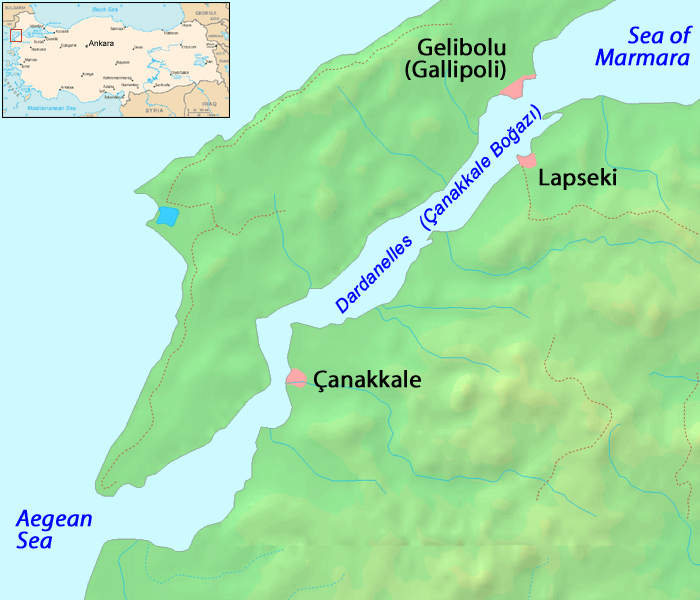
Dardanelles
View on Wikipedia

Key Information


The Dardanelles (/ˌdɑːrdəˈnɛlz/ DAR-də-NELZ; Turkish: Çanakkale Boğazı, lit. 'Strait of Çanakkale'; Greek: Δαρδανέλλια, romanized: Dardanéllia), also known as the Strait of Gallipoli (after the Gallipoli peninsula) and in classical antiquity as the Hellespont (/ˈhɛlɪspɒnt/ HEL-isp-ont; Classical Greek: Ἑλλήσποντος, romanized: Hellḗspontos, lit. 'Sea of Helle'), is a narrow, natural strait and internationally significant waterway in northwestern Turkey that forms part of the continental boundary between Asia and Europe and separates Asian Turkey from European Turkey. Together with the Bosporus, the Dardanelles forms the Turkish Straits.
One of the world's narrowest straits used for international navigation, the Dardanelles connects the Sea of Marmara with the Aegean and Mediterranean seas while also allowing passage to the Black Sea by extension via the Bosporus. The Dardanelles is 61 kilometres (38 mi) long and 1.2 to 6 kilometres (0.75 to 3.73 mi) wide. It has an average depth of 55 metres (180 ft) with a maximum depth of 103 metres (338 ft) at its narrowest point abreast the city of Çanakkale. The first fixed crossing across the Dardanelles opened in 2022 with the completion of the 1915 Çanakkale Bridge.
Most of the northern shores of the strait along the Gallipoli peninsula (Turkish: Gelibolu) are sparsely settled, while the southern shores along the Troad peninsula (Turkish: Biga) are inhabited by the city of Çanakkale's urban population of 110,000.
Names
[edit]The contemporary Turkish name Çanakkale Boğazı, meaning 'Çanakkale Strait', is derived from the eponymous midsize city that adjoins the strait, itself meaning 'pottery fort'—from چاناق (çanak, 'pottery') + قلعه (kale, 'fortress')—in reference to the area's famous pottery and ceramic wares, and the landmark Ottoman fortress of Sultaniye.
The English name Dardanelles is an abbreviation of Strait of the Dardanelles. During Ottoman times there was a castle on each side of the strait. These castles together were called the Dardanelles,[1][2] probably named after Dardanus, an ancient city on the Asian shore of the strait which in turn was said to take its name from Dardanus, the mythical son of Zeus and Electra. The name comes from the Dardani in the Balkans, according to Papazoglu.[3]
The ancient Greek name Ἑλλήσποντος (Hellēspontos) means "Sea of Helle", and was the ancient name of the narrow strait. It was variously named in classical literature Hellespontium Pelagus, Rectum Hellesponticum, and Fretum Hellesponticum. These names derived from that of Helle, daughter of King Athamas, who drowned here after falling from a flying golden ram in the mythology of the Golden Fleece.[4]
Geography
[edit]As a maritime waterway, the Dardanelles connects various seas along the Eastern Mediterranean, the Balkans, the Near East, and Western Eurasia, and specifically connects the Aegean Sea to the Sea of Marmara. The Marmara further connects to the Black Sea via the Bosporus, while the Aegean further links to the Mediterranean. Thus, the Dardanelles allows maritime connections from the Black Sea all the way to the Mediterranean Sea—and on to the Atlantic Ocean via Gibraltar, and to the Indian Ocean through the Suez Canal—making it a crucial international waterway, in particular for the passage of goods going to and coming from Russia, Ukraine, and other nations bordering the Black Sea.
The particular geography of the strait and that of its shores has also made it important from a geostrategic and military point of view. The strait is long and narrow, and contains multiple curves and sharp angles formed as its shores, including some high cliffs and bluffs, both contain and protrude out into the water body. The overall length of the strait, and the geography of the land which forms it on both sides, mean that it is a place where the passage of ships can be controlled from land-based (unsinkable) positions. Control of the area has thus long been fought over, including notably during the ancient Greco-Persian and Peloponnesian Wars, the Gallipoli Campaign (1915-16) of the First World War, and the Turkish War of Independence (1919-23).
The strait is located at approximately 40°13′N 26°26′E / 40.217°N 26.433°E.
Present morphology
[edit]The strait is 61 kilometres (38 mi) long, and 1.2 to 6 kilometres (0.7 to 3.7 mi) wide, averaging 55 metres (180 ft) deep with a maximum depth of 103 metres (338 ft) at its narrowest point at Nara Burnu, abreast Çanakkale. There are two major currents through the strait: a surface current flows from the Black Sea towards the Aegean Sea, and a more saline undercurrent flows in the opposite direction.[5]
The Dardanelles is unique as a natural formation in many respects. The very narrow and winding shape of the strait is more akin to that of a river (thus, one might also talk of its 'banks' rather than its 'shores'). It also is the sole connection point of two far larger bodies of water and so experiences significant tidal water movements and associated currents and effects. For ships, it is thus considered one of the most hazardous, crowded, difficult, and potentially dangerous waterways in the world. The currents produced by tidal action in the Black Sea and the Sea of Marmara are such that ships under sail must wait at anchorage for the right conditions before entering the Dardanelles.
History
[edit]As part of the only passage between the Black Sea and the Mediterranean, the Dardanelles has always been of great importance from a commercial and military point of view, and remains strategically important today. It is a major sea access route for numerous countries, including Russia and Ukraine. Control over it has been an objective of a number of hostilities in modern history, notably the attack of the Allied Powers on the Dardanelles during the 1915 Battle of Gallipoli in the course of World War I.
Ancient Dardanian, Persian, Roman, and Byzantine eras (pre-1454)
[edit]Dardanian and Persian history
[edit]
The ancient city of Troy was located near the western entrance of the strait, and the strait's Asiatic shore was the focus of the Trojan War. Troy was able to control the marine traffic entering this vital waterway. The Persian army of Xerxes I of Persia and later the Macedonian army of Alexander the Great crossed the Dardanelles in opposite directions to invade each other's lands, in 480 BC and 334 BC respectively.
Herodotus says that, circa 482 BC, Xerxes I (the son of Darius) had two pontoon bridges built across the width of the Hellespont at Abydos, in order that his huge army could cross from Persia into Greece. This crossing was named by Aeschylus in his tragedy The Persians as the cause of divine intervention against Xerxes.[6]
According to Herodotus (vv.34), both bridges were destroyed by a storm and Xerxes had those responsible for building the bridges beheaded and the strait itself whipped. The Histories of Herodotus vii.33–37 and vii.54–58 give details of building and crossing of Xerxes' Pontoon Bridges. Xerxes is then said to have thrown fetters into the strait, given it three hundred lashes with multiple whips and branded it with red-hot irons as the soldiers shouted at the water.[7]
Herodotus commented that this was a "highly presumptuous way to address the Hellespont" but in no way atypical of Xerxes. (vii.35)
Harpalus the engineer is said to have eventually helped the invading armies to cross by lashing the ships together with their bows facing the current and adding two additional anchors to each ship.
From the perspective of ancient Greek mythology Helle, the daughter of Athamas, supposedly was drowned at the Dardanelles in the legend of the Golden Fleece. Likewise, the strait was the scene of the legend of Hero and Leander, wherein the lovesick Leander swam the strait nightly in order to tryst with his beloved, the priestess Hero, but was ultimately drowned in a storm.
Byzantine history
[edit]The Dardanelles were vital to the defence of Constantinople during the Byzantine period.
Also, the Dardanelles was an important source of income for the ruler of the region. At the Istanbul Archaeological Museum a marble plate contains a law by the Byzantine Emperor Anastasius I (491–518 AD), that regulated fees for passage through the customs office of the Dardanelles. Translation:
... Whoever dares to violate these regulations shall no longer be regarded as a friend, and he shall be punished. Besides, the administrator of the Dardanelles must have the right to receive 50 golden Litrons, so that these rules, which we make out of piety, shall never ever be violated ... The distinguished governor and major of the capital, who already has both hands full of things to do, has turned to our lofty piety in order to reorganize the entry and exit of all ships through the Dardanelles ... Starting from our day and also in the future, anybody who wants to pass through the Dardanelles must pay the following:
– All wine merchants who bring wine to the capital (Constantinopolis), except Cilicians, have to pay the Dardanelles officials 6 follis and 2 sextarius of wine.
– In the same manner, all merchants of olive-oil, vegetables and lard must pay the Dardanelles officials 6 follis. Cilician sea-merchants have to pay 3 follis and in addition to that, 1 keration (12 follis) to enter, and 2 keration to exit.
– All wheat merchants have to pay the officials 3 follis per modius, and a further sum of 3 follis when leaving.
Since the 14th century the Dardanelles have almost continuously been controlled by the Turks.
Ottoman era (1354–1922)
[edit]
The Dardanelles continued to constitute an important waterway during the period of the Ottoman Empire, which conquered Gallipoli in 1354.
Ottoman control of the strait continued largely without interruption or challenges until the 19th century, when the Empire started its decline.
Nineteenth century
[edit]Gaining control of, or guaranteed access to, the strait became a key foreign-policy goal of the Russian Empire during the 19th century. During the Napoleonic Wars, Russia—supported by Great Britain in the Dardanelles Operation—blockaded the straits in 1807.
In 1833, following the Ottoman Empire's defeat in the Russo-Turkish War of 1828–1829, Russia pressured the Ottomans to sign the Treaty of Hunkiar Iskelesi—which required the closing of the straits to warships of non-Black Sea powers at Russia's request. That would have effectively given Russia a free hand in the Black Sea.
This treaty alarmed the Ottoman Empire, who were concerned that the consequences of potential Russian expansionism in the Black Sea and Mediterranean regions could conflict with their own possessions and economic interest in the region. At the London Straits Convention in July 1841, the United Kingdom, France, Austria, and Prussia pressured Russia to agree that only Turkish warships could traverse the Dardanelles in peacetime. The United Kingdom and France subsequently sent their fleets through the straits to defend the Danube front and to attack the Crimean Peninsula during the Crimean War of 1853–1856 – but they did so as allies of the Ottoman Empire. Following the defeat of Russia in the Crimean War, the Congress of Paris in 1856 formally reaffirmed the London Straits Convention.
World War I
[edit]
.jpg)
.jpg)

In 1915 the Allies sent a substantial invasion force of British, Indian, Australian, New Zealand, French and Newfoundland troops to attempt to open up the straits. In the Gallipoli campaign, Turkish troops trapped the Allies on the coasts of the Gallipoli peninsula. The campaign damaged the career of Winston Churchill, then First Lord of the Admiralty (in office 1911–1915), who had eagerly promoted the (unsuccessful) use of Royal Navy sea power to force open the straits. Mustafa Kemal Atatürk, subsequent founder of the Republic of Turkey, served as an Ottoman commander during the land campaign.
The Turks mined the straits to prevent Allied ships from penetrating them but, in minor actions two submarines, one British and one Australian, did succeed in penetrating the minefields. The British submarine sank an obsolete Turkish pre-dreadnought battleship off the Golden Horn of Istanbul. Sir Ian Hamilton's Mediterranean Expeditionary Force failed in its attempt to capture the Gallipoli peninsula, and the British cabinet ordered its withdrawal in December 1915, after eight months' fighting. Total Allied deaths included 41,000 British and Irish,[8] 15,000 French, 8,700 Australians, 2,700 New Zealanders, 1,370 Indians and 49 Newfoundlanders.[9] Total Turkish deaths were around 60,000.
Following the war, the 1920 Treaty of Sèvres demilitarized the strait and made it an international territory under the control of the League of Nations. The Ottoman Empire's non-ethnically Turkish territories were broken up and partitioned among the Allied Powers, and Turkish jurisdiction over the straits curbed.
Turkish republican and modern eras (1923–present)
[edit]After the dissolution of the Ottoman Empire following a lengthy campaign by Turks as part of the Turkish War of Independence against both the Allied Powers and the Ottoman court, the Republic of Turkey was created in 1923 by the Treaty of Lausanne, which established most of the modern sovereign territory of Turkey and restored the straits to Turkish territory, with the condition that Turkey keep them demilitarized and allow all foreign warships and commercial shipping to traverse the straits freely.
As part of its national security strategy, Turkey eventually rejected the terms of the treaty, and subsequently remilitarized the straits area over the following decade. Following extensive diplomatic negotiations, the reversion was formalized under the Montreux Convention Regarding the Regime of the Turkish Straits on 20 July 1936. That convention, which is still in force today, treats the straits as an international shipping lane while allowing Turkey to retain the right to restrict the naval traffic of non-Black Sea states.
During World War II, through February 1945, when Turkey was neutral for most of the length of the conflict, the Dardanelles were closed to the ships of the belligerent nations. Turkey declared war on Germany in February 1945, but it did not employ any offensive forces during the war.
In July 1946, the Soviet Union sent a note to Turkey proposing a new régime for the Dardanelles that would have excluded all nations except the Black Sea powers. The second proposal was that the straits should be put under joint Turkish-Soviet defence. This meant that Turkey, the Soviet Union, Bulgaria and Romania would be the only states having access to the Black Sea through the Dardanelles. The Turkish government however, under pressure from the United States, rejected these proposals.[10]
Turkey joined NATO in 1952, thus affording its straits even more strategic importance as a commercial and military waterway.
In more recent years,[when?] the Turkish Straits have become particularly important for the oil industry. Russian oil, from ports such as Novorossyisk, is exported by tankers primarily to western Europe and the U.S. via the Bosporus and the Dardanelles straits.
The Dardanelles were closed in late February 2022 to all foreign warships at the beginning of the Russian invasion of Ukraine in accordance with the Montreux Convention.[11]
Crossings
[edit]
Maritime
[edit]The waters of the Dardanelles are traversed by numerous passenger and vehicular ferries daily, as well as recreational and fishing boats ranging from dinghies to yachts owned by both public and private entities.
The strait also experiences significant amounts of commercial shipping traffic.
Land
[edit]The Çanakkale 1915 Bridge joins Lapseki, a district of Çanakkale, on the Asian side and Sütlüce, a village of the Gelibolu district, on the European side.[13] It is part of planned expansions to the Turkish National Highway Network. Work on the bridge began in March 2017, and it was opened on March 18, 2022.[14]
Subsea
[edit]Two submarine cable systems transmitting electric power at 400 kV bridge the Dardanelles to feed west and east of Istanbul. They have their own landing stations in Lapseki and Sütlüce. The first, situated in the northeast quarter portion of the strait, was energised in April 2015 and provides 2 GW via six phases 400 kV AC 3.9 km (2.4 mi) far through the sea. The second, somewhat in the middle of the strait, was still under construction in June 2016 and will provide similar capabilities to the first line.
Both subsea power lines cross four optical fibre data lines laid earlier along the strait.[15] A published map shows communication lines leading from Istanbul into the Mediterranean, named MedNautilus and landing at Athens, Sicily and elsewhere.[16]
Gallery
[edit]-
 Marble plate with 6th century AD Byzantine law regulating payment of customs in the Dardanelles
 -
 Historic map of the Dardanelles by Piri Reis
 -

-
 Map of the Dardanelles drawn by G. F. Morrell, 1915, showing the Gallipoli peninsula and the west coast of Turkey, as well as the location of front-line troops and landings during the Gallipoli Campaign
 -
 A view of the Dardanelles from Gallipoli peninsula
 -
 A view of Çanakkale from the Dardanelles
 -

-
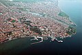 Aerial view of the city of Çanakkale
 -
 Dardanelles in 2021
 -
 The narrowest section of the Dardanelles


See also
[edit]References
[edit]- ^ Hoogstraten, David van; Nidek, Matthaeus Brouërius van; Schuer, Jan Lodewyk (1727). "Dardanellen". Groot algemeen historisch, geografisch, genealogisch, en oordeelkundig woordenboek (in Dutch). Vol. 4: D en E. Amsterdam/Utrecht/The Hague. p. 25. OCLC 1193061215. Archived from the original on 24 October 2017.
- ^ Crabb, George (1833). "Dardanelles". Universal Historical Dictionary. Vol. 1. London. OCLC 1158045075.
- ^ Papazoglu, F. (1978). The Central Balkan Tribes in Pre-Roman Times: Triballi, Autariatae, Dardanians, Scordisci and Moesians. Niederlande: Hakkert, p. 132
- ^ One or more of the preceding sentences incorporates text from a publication now in the public domain: Chisholm, Hugh, ed. (1911). "Hellespont". Encyclopædia Britannica. Vol. 13 (11th ed.). Cambridge University Press. p. 246.
- ^ Rozakis, Christos L.; Stagos, Petros N. (1987). The Turkish Straits. Martinus Nijhoff Publishers. p. 1. ISBN 90-247-3464-9. Retrieved 1 August 2017.
- ^ Aeschylus. "The Persians". Translated by Potter, Robert. Archived from the original on 19 November 2003. Retrieved 26 September 2003 – via The Internet Classics Archive.
- ^ Green, Peter (1996). The Greco-Persian Wars. Berkeley; London: The University of California Press. p. 75. ISBN 0-520-20573-1.
- ^ "Key facts of Gallipoli casualties". SBS World News. 17 April 2014. Retrieved 14 November 2024.
- ^ "Gallipoli casualties by country". New Zealand History. New Zealand Ministry for Culture and Heritage. 1 March 2016. Retrieved 6 November 2020.
- ^ Cabell, Phillips B. H. (1966). The Truman presidency : the history of a triumphant succession. New York: Macmillan. pp. 102–103. OCLC 1088163662.
- ^ "Groundbreaking ceremony for bridge over Dardanelles to take place on March 18". Hürriyet Daily News. 17 March 2017. Retrieved 19 March 2017.
- ^ "Project Information". 1915 Çanakkale Bridge. Retrieved 21 March 2022.
- ^ "Turkey opens record-breaking bridge between Europe and Asia". CNN. 18 March 2022. Retrieved 19 March 2022.
- ^ Yüce, Gülnazi (7–8 June 2016). Submarine Cable Projects (2-03) (PDF). First South East European Regional CIGRÉ Conference. Portorož, Slovenia. Archived from the original (PDF) on 9 April 2018. Retrieved 8 April 2018.
- ^ "Submarine Cable Map 2017". TeleGeography. Archived from the original on 28 September 2017. Retrieved 9 April 2018.
External links
[edit]- Pictures of the city of Çanakkale
- Map of Hellespont
- Livius.org: Hellespont Archived 1 September 2013 at the Wayback Machine
- Monuments and memorials of the Gallipoli campaign along the Dardanelles
- Old Maps of the Dardanelles, Eran Laor Cartographic collection, The National Library of Israel
| International | |
|---|---|
| National | |
| Geographic | |
| Other | |
Dardanelles
View on GrokipediaThe Dardanelles (Turkish: Çanakkale Boğazı), anciently known as the Hellespont, is a narrow strait in northwestern Turkey separating the European Gallipoli Peninsula from the Asian mainland and linking the Aegean Sea with the Sea of Marmara, thus forming the primary maritime route from the Black Sea to the Mediterranean.[1][2]
The strait extends approximately 61 kilometers in length, with widths ranging from 1.2 to 6.5 kilometers, an average depth of 55 meters, and a maximum depth exceeding 100 meters in its deeper sections.[1][3]
As part of the Turkish Straits system alongside the Bosporus, it has held critical strategic value for trade, naval operations, and military campaigns throughout antiquity and modern history, including Persian crossings, Ottoman defenses, and the 1915–1916 Gallipoli Campaign of World War I.[4]
Maritime traffic through the Dardanelles is regulated by the 1936 Montreux Convention, which guarantees peacetime freedom of passage for civilian vessels while permitting Turkey to impose restrictions on foreign warships during times of war or threat to its security.[5][6]
Names and Etymology
Historical and Mythological Origins
The ancient Greek name for the strait, Hellespontos (Ἑλλήσποντος), translates to "Sea of Helle" and stems from the mythological narrative of Helle, daughter of King Athamas of Boeotia and the cloud nymph Nephele. In the legend, Athamas's second wife Ino sought to eliminate Helle and her twin brother Phrixus as rivals to her own children, prompting Nephele to send a golden-fleeced ram to carry them away; Helle lost her grip and drowned in the strait during their flight toward Colchis, naming the waters after her fall.[7][8] This myth, preserved in sources like Apollodorus's Bibliotheca (c. 2nd century BCE), links the Hellespont to the precursor events of the Argonauts' quest for the Golden Fleece, emphasizing the strait's role as a perilous boundary between Europe and Asia in early Greek lore.[8] The designation "Dardanelles" originates from Dardanus, a figure in Greek mythology portrayed as the son of Zeus and the Pleiad Electra, who migrated from Arcadia or Samothrace to the Troad region on the Asian shore, founding the city of Dardanus near the strait around the site of modern Maltepe. Dardanus established the kingdom of Dardania, becoming the progenitor of the Dardanians and, through his descendants like Tros, the royal line of Troy, as recounted in works such as Homer's Iliad (c. 8th century BCE) and later genealogies by Hellanicus of Lesbos (5th century BCE).[9][10] The name persisted into historical usage, applied by Ottoman Turks to paired castles—Sultanhisar (Asian side) and Yenihisar (European side)—constructed in 1452–1456 CE under Sultan Mehmed II to fortify the strait against Venetian naval threats, collectively termed the "Dardanelles" after the ancient city and mythic founder.[9] Historically, the strait appears in records predating formalized myths, with Linear B tablets from Pylos (c. 1450–1350 BCE) possibly referencing maritime routes through the region, though unambiguous textual evidence emerges in Homer, who describes it as the "swift Hellespont" in the Iliad (Book 2, line 825) as the waterway separating the Achaean camp from Troy.[7] These early attestations underscore the strait's longstanding significance as a chokepoint for migration, trade, and conflict, bridging Aegean navigation to the Black Sea via the Propontis (modern Sea of Marmara), without reliance on later embellished etiologies.[7]Modern and Alternative Designations
In the Republic of Turkey, the strait is officially known as Çanakkale Boğazı, a designation derived from the adjacent provincial capital Çanakkale, whose name in turn originates from Ottoman-era coastal fortifications referred to as çanak kale ("pot fortress").[11] This Turkish name has been in standard use domestically since the early 20th century, emphasizing local geography over classical European terminology.[12] Internationally, the strait retains the English-language designation Dardanelles, which predominates in geopolitical, navigational, and scholarly contexts outside Turkey due to entrenched historical conventions and its role in global maritime documentation.[13] In some English technical usages, such as shipping charts and environmental reports, it appears as the Çanakkale Strait or Strait of Çanakkale to align with Turkish nomenclature while maintaining accessibility. Other modern alternative designations include Δαρδανέλλια (Dardanellia) in Greek, reflecting Byzantine influences and contemporary Hellenic references to the waterway. Collectively with the Bosporus, it forms the Turkish Straits, a term employed in international law and diplomacy to denote the paired chokepoints linking the Black Sea to the Mediterranean.[14] These variations underscore the strait's dual role in national sovereignty assertions and supranational transit regimes, with no single name universally supplanting others in global usage as of 2025.[13]Geography
Physical Morphology and Dimensions
The Dardanelles, also known as the Çanakkale Strait, forms a narrow, elongated waterway measuring 61 kilometers in length, connecting the Aegean Sea to the Sea of Marmara.[15] [1] Its width varies significantly along its course, narrowing to a minimum of 1.2 kilometers at the Narrows near Çanakkale and expanding to a maximum of 6.5 kilometers in broader sections.[15] [1] This variability contributes to the strait's river-like morphology, with steep banks rather than expansive shores, dividing the Gallipoli Peninsula on the European side from the Anatolian mainland on the Asiatic side.[1] The average depth of the strait is approximately 55 meters, with a maximum depth reaching about 103 meters, facilitating navigation but also generating strong tidal and density-driven currents that influence water flow dynamics.[13] [16] The channel follows a generally northeast-southwest orientation but includes gentle bends and constrictions, enhancing its tortuous character and making it susceptible to rapid surface outflows from the Marmara toward the Aegean, contrasted by subsurface inflows.[1] [13] These physical features, shaped by tectonic subsidence and erosion, underscore the strait's role as a critical hydrological conduit between the Black Sea basin and the Mediterranean.[17]Geological Formation and Hydrology
The Dardanelles Strait occupies a fault-controlled depression within the broader tectonic framework of the North Anatolian Fault zone, a right-lateral strike-slip system accommodating the westward extrusion of the Anatolian plate. Regional deformation, including folding in the strait's vicinity, initiated around 5 million years ago, coinciding with the fault's propagation into the northern Aegean domain and marking the onset of significant crustal strain that shaped the local morphology.[18] [19] The strait's narrow valley configuration emerged during the Pliocene through combined effects of strike-slip tectonics, localized transtension, and uplift of the flanking Gelibolu (Gallipoli) and Biga peninsulas, facilitating Aegean marine incursion into the subsiding Marmara basin.[3] [20] This tectonic setting yields a waterway 61 km long, with widths ranging from 1.2 km to 6 km, an average depth of 55 m, and local maxima exceeding 100 m, transitioning seaward via a submarine canyon.[3] [21] Hydrologically, the strait sustains a baroclinic two-layer exchange driven by persistent density gradients from salinity contrasts, with the upper layer (typically 20-30 m thick) comprising lower-salinity Marmara water (29-32 psu, influenced by Black Sea inflow via the Bosporus at ~17.8 psu) flowing southward to the Aegean at mean speeds of 40-70 cm/s, while the lower layer transports denser Aegean inflow (38-39 psu) northward at ~25 cm/s.[22] [23] [24] This regime yields a net upper-layer outflow volume flux of ~300-500 m³/s under mean conditions, moderated by synoptic wind and sea-level variability, with entrainment across the pycnocline elevating upper-layer salinity by up to 1.7-fold through mixing with intruding Aegean water.[25] [22] The flow's stability hinges on the strait's shallow sill (~70-80 m) restricting deep ventilation, thereby preserving stratification despite episodic turbulence from tidal and barotropic components.[3] [21]Climate, Ecology, and Environmental Challenges
The Dardanelles region experiences a Mediterranean climate characterized by mild, wet winters and hot, dry summers. Annual average temperatures in Çanakkale, the principal city along the strait, reach 15.8 °C, with July highs averaging 27.5 °C and January lows around 5.5 °C. Precipitation totals approximately 694 mm per year, concentrated primarily from October to April, with minimal rainfall in summer months like August, which sees less than 10 mm. Strong northerly winds, known as the Meltemi, prevail in summer, influencing local weather patterns and sea conditions.[26][27] Ecologically, the strait serves as a critical biogeographic corridor linking the Aegean and Marmara Seas, facilitating species exchange between Mediterranean and Black Sea biota. Marine biodiversity includes diverse benthic communities, seagrass meadows dominated by Posidonia oceanica, and assemblages of fish, invertebrates, and algae adapted to varying salinities and currents. Surveys of artificial habitats, such as shipwrecks in the Çanakkale Strait, reveal rich macrofauna including sponges, bryozoans, and crustaceans, underscoring the area's role in regional endemism despite its transitional hydrology. However, the strait's high flow rates and depth variations limit extensive coral or deep-sea habitats, favoring current-tolerant flora and fauna.[28][29][30] Environmental challenges stem primarily from anthropogenic pressures and hydrodynamic forces. Heavy metal contamination, including elevated levels of cadmium, lead, and phosphorus in sediments from streams discharging into the strait, poses risks to benthic organisms and bioaccumulates in species like Mediterranean mussels (Mytilus galloprovincialis). Shipping traffic contributes to oil spills, ballast water introductions of invasives, and chronic pollution, exacerbating eutrophication linked to the 2021 Marmara Sea mucilage bloom that extended into the Dardanelles, causing hypoxia and mass marine mortality. Sedimentation dynamics, driven by strong tidal currents and river inputs, lead to localized erosion and deposition, with historical lowstands exposing sills and modern flows scouring seafloors. Climate change amplifies these issues through projected sea-level rise of 0.3–1.0 m by 2100 along Turkish coasts, promoting coastal erosion, saltwater intrusion, and inundation of low-lying areas like the Gallipoli Peninsula.[31][32][33][34][35][36][37]Strategic and Economic Significance
Military and Geopolitical Role
The Dardanelles Strait serves as the sole maritime link between the Black Sea and the Mediterranean, rendering it a critical chokepoint for naval movements and military logistics throughout history.[38] This 61-kilometer waterway, narrowing to as little as 1.2 kilometers at points, has enabled defenders to fortify its shores effectively against invasions, as demonstrated in multiple naval engagements.[39] Ottoman forces, leveraging coastal batteries and mines, repelled assaults during the 17th and 19th centuries, including the Venetian fleet's failed incursion in 1656 and Russian naval efforts in 1807.[40] The most prominent military episode occurred during World War I's Gallipoli Campaign, launched by British and French forces in February 1915 to seize the strait, knock the Ottoman Empire out of the war, and secure supply lines to Russia.[41] A naval bombardment on 19 February targeted Ottoman forts, but mines and mobile artillery inflicted heavy losses, sinking three Allied battleships on 18 March alone.[39] Amphibious landings followed on 25 April, with ANZAC troops establishing positions at Ari Burnu amid 5,000 initial casualties, yet entrenched Ottoman defenses under Mustafa Kemal prevented breakthroughs.[42] The eight-month stalemate ended in evacuation by 9 January 1916, yielding approximately 250,000 Allied casualties—including 44,000 deaths—and comparable Ottoman losses of around 250,000 to 300,000.[43] [44] Geopolitically, the strait's control has shaped regional power dynamics, particularly under Turkish sovereignty since the Republic's founding. The 1936 Montreux Convention affirmed Turkey's authority to regulate warship transit, permitting Black Sea states limited tonnage while barring non-riparian submarines and allowing wartime closures to belligerents.[45] This framework curtailed unrestricted access for powers like Russia, whose Black Sea Fleet relies on the route for Mediterranean operations.[46] As a NATO member since 1952, Turkey balances alliance commitments with pragmatic ties to Russia, invoking the convention on 28 February 2022 to halt warship passages amid the Ukraine conflict, thereby restricting Russian reinforcements while exempting returning vessels.[47] [48] Such actions underscore Turkey's pivotal role in containing escalation between NATO and Russia, leveraging the strait's defensibility to influence Black Sea security without direct confrontation.[49]Commercial Shipping and Trade Impacts
The Dardanelles Strait serves as a critical maritime chokepoint connecting the Aegean Sea to the Sea of Marmara, thereby linking Black Sea ports to Mediterranean trade routes and facilitating the export of commodities such as grain, oil, and metals from Russia, Ukraine, and other riparian states.[50] This connectivity underpins economic security for Turkey and Black Sea countries by enabling access to global markets without reliance on alternative, longer routes around continents.[51] Annual commercial traffic through the Turkish Straits, including the Dardanelles, averaged approximately 42,000 vessels in 2022, positioning it among the world's busiest waterways and handling substantial cargo volumes critical for energy and agricultural trade.[50] Gross tonnage transiting the straits reached about 541.5 million in 2023, reflecting a 14.3% decline from prior years amid disruptions from the Russia-Ukraine conflict, which reduced shipments of Russian oil and Ukrainian grain despite alternative export corridors.[52] Under the 1936 Montreux Convention, merchant vessels enjoy free passage through the Dardanelles regardless of wartime conditions, provided Turkey remains neutral, which has preserved commercial flows even during regional conflicts by barring only warships.[53] This regime supports uninterrupted trade but exposes the strait to risks from high-density traffic, including potential accidents and congestion in its narrow 1.2 km width, amplifying vulnerabilities in global supply chains for Black Sea exports.[54] The strait's role in energy corridors underscores its geopolitical weight, as disruptions could elevate costs for Europe-bound oil and grain, though diversified routes have mitigated some impacts in recent years.[55]Infrastructure and Crossings
The 1915 Çanakkale Bridge, opened on March 18, 2022, provides the first fixed road crossing over the Dardanelles strait, linking the Asian shore at Lapseki to the European shore at Gallipoli Peninsula.[56] With a main suspension span of 2,023 meters, it holds the record for the longest such span globally, surpassing Japan's Akashi Kaikyo Bridge.[57] The bridge's total length measures 4,608 meters, supported by towers rising to 318 meters above sea level, designed to accommodate maritime traffic with a clearance of 64 meters.[58] As part of a broader 321-kilometer highway project, it reduces transit time across the strait from over an hour by ferry to approximately six minutes, handling up to 45,000 vehicles daily.[59] Tolls for passenger cars stand at 200 Turkish lira per crossing, collected electronically.[60] Prior to the bridge, vehicular and pedestrian crossings relied on roll-on/roll-off ferries operated by Gestaş Deniz Ulaşım, connecting Çanakkale on the Asian side to Eceabat and Lapseki on the European side.[61] These services run frequently, with departures from Çanakkale every 30 minutes from 6:00 a.m. to 9:45 p.m., supplemented by later sailings, accommodating cars, trucks, and passengers.[61] Ferry journeys last about 20-30 minutes, serving as a vital link for local traffic and tourism despite the bridge's introduction, which has shifted much heavy vehicle volume to the fixed span.[62] No undersea tunnels currently exist across the Dardanelles, though proposals for a rail tunnel have been discussed since the early 2000s as part of Turkey's high-speed rail network; construction has not commenced as of 2025.[63] Supporting infrastructure includes approach roads and viaducts integrated into the bridge project, enhancing connectivity between the Marmara and Aegean regions.[64]International Treaties and Sovereignty
Early Modern Agreements (1809–1841)
The Treaty of the Dardanelles, signed on January 5, 1809, between the Ottoman Empire and Great Britain at Çanak (modern Çanakkale), concluded the Anglo-Turkish War of 1807–1809 amid the Napoleonic conflicts.[65] This bilateral agreement affirmed the Ottoman Empire's longstanding practice of closing the Dardanelles and Bosporus straits to foreign warships, a policy rooted in imperial edicts dating to the 18th century, thereby recognizing Ottoman sovereignty over maritime access to the Black Sea.[66] In exchange, Britain secured the restoration of extensive commercial and capitulatory privileges within Ottoman territories, including tariff exemptions for British merchants, and pledged naval protection against French aggression, alongside arms supplies to Ottoman forces.[65] The treaty's clauses on straits closure, particularly Articles V and XI, explicitly barred non-Ottoman naval vessels from passage, reinforcing the empire's defensive control while aligning British interests against continental rivals.[66] Subsequent Russo-Ottoman tensions, exacerbated by the 1828–1829 war and the Treaty of Adrianople (September 14, 1829), heightened European scrutiny of straits access, as Russia gained territorial concessions and influence over principalities bordering the Black Sea but initially respected the 1809 closure principle.[67] However, during the 1831–1833 Egyptian crisis, when Muhammad Ali Pasha of Egypt threatened Istanbul, Russian military intervention on behalf of Sultan Mahmud II led to the Treaty of Hünkâr İskelesi on July 8, 1833.[68] This defensive alliance obligated the Ottomans to close the Dardanelles to all foreign warships upon Russian request, ostensibly for mutual security, but a secret protocol permitted Russian naval forces to transit the straits exclusively to aid the Ottomans, effectively granting Russia veto power over Black Sea access and alarming Britain and France as a breach of the balance established in 1809.[68] The agreement amended aspects of the 1829 Adrianople Treaty, consolidating Russian strategic leverage amid Ottoman vulnerability, with approximately 10,000 Russian troops temporarily stationed near the straits until their withdrawal in 1834 under diplomatic pressure.[67] The 1833 treaty provoked concerted opposition from Britain, France, and other powers, who viewed it as enabling Russian dominance over Ottoman straits policy and potential Mediterranean expansion.[67] Diplomatic maneuvers, including British mediation and French naval demonstrations, compelled Russia to acquiesce to multilateral regulation, culminating in the London Straits Convention of July 13, 1841.[69] Signed by the Ottoman Empire alongside Britain, France, Russia, Austria, and Prussia, this international accord formalized the prohibition on foreign warships passing through the Dardanelles and Bosporus in peacetime, preserving Ottoman authority to enforce closure while nullifying the unilateral Russian privileges of 1833.[69] The convention's provisions allowed unlimited merchant shipping but restricted naval transit to Ottoman vessels only during peace, with exceptions for light warships aiding Ottoman enforcement; it marked the first European-wide codification of straits rules, driven by collective interest in Ottoman territorial integrity against internal revolts and Russian adventurism.[67] This framework endured until wartime modifications, reflecting a temporary consensus on containing great-power rivalries through neutralized access.[69]20th Century Conventions and Turkish Control
The Treaty of Sèvres, signed on August 10, 1920, between the Allied Powers and the Ottoman Empire, proposed an international regime for the Straits, including demilitarization and Allied occupation of strategic points, but it was never ratified by the Turkish National Movement led by Mustafa Kemal Atatürk and was superseded following Turkish military successes.[70] The subsequent Treaty of Lausanne, signed on July 24, 1923, between the Republic of Turkey and the Allied Powers, formally recognized Turkish sovereignty over the surrounding territories while establishing a demilitarized zone along the Straits under the separate Convention Relating to the Régime of the Straits.[71] This convention guaranteed freedom of transit and navigation for merchant vessels and limited warship passage in peacetime, with an international commission overseeing enforcement, reflecting Allied concerns over unrestricted access to the Black Sea but constraining full Turkish military control.[72] Rising international tensions in the 1930s, including Italian aggression and the perceived inadequacy of the demilitarized regime for Turkish security, prompted negotiations leading to the Montreux Convention Regarding the Regime of the Straits, signed on July 20, 1936, by Turkey, the Soviet Union, and other powers.[6] The convention abolished the international commission, permitted Turkey to remilitarize the Straits zone, and granted Ankara sovereign authority to regulate traffic, including prior notification and tonnage limits for non-Black Sea state warships in peacetime, closure to belligerent warships during wartime if Turkey remained neutral, and free passage for merchant ships.[71] These provisions effectively transferred operational control to Turkey, prioritizing its security interests over the broader internationalization of the Lausanne era, while maintaining the principle of free commercial navigation.[73] The Montreux Convention endured through World War II, enabling Turkey to enforce closures against Axis and Allied naval forces alike to preserve neutrality, and faced no formal revision despite postwar Soviet demands for joint control in 1945–1947, which were rebuffed amid Cold War alignments.[70] By the late 20th century, the regime had solidified Turkish de facto sovereignty, with Ankara exercising veto power over military transits and implementing traffic services, as evidenced by consistent application without successful challenges from Black Sea or Mediterranean states.[73] This framework balanced Turkey's strategic gatekeeping role with international passage rights, averting the full internationalization attempted post-World War I.Contemporary Regulations and Disputes
The Montreux Convention Regarding the Regime of the Straits, signed on July 20, 1936, remains the foundational international agreement regulating passage through the Dardanelles and Bosphorus straits, affirming Turkish sovereignty while permitting free transit for merchant vessels of all nations in peacetime and limiting warship passages based on tonnage and prior notification.[53] Under its terms, non-Black Sea powers face caps of 30,000 tons total for surface warships and 15 submarines at a time, with demilitarization of adjacent zones except for Turkish forces.[74] The Convention allows Turkey, as a neutral party in wartime, to prohibit belligerent warships from passing if it threatens its security, a provision invoked without successful challenge in recent conflicts.[75] Turkey supplements the Convention with domestic maritime traffic regulations enforced via the Turkish Straits Vessel Traffic Services (VTS), mandating pilotage, tug assistance for certain vessels, and adherence to traffic separation schemes to manage high volumes—over 43,000 transits annually in recent years amid growing commercial shipping.[76] As of October 13, 2025, updated procedures require pilots and tugs for liquefied petroleum gas (LPG) carriers over 150 meters in length during Dardanelles transits, including nighttime allowances under strict conditions, while revisions effective February 1, 2025, eliminated certain outdated preparatory mandates like specific pilot ladder setups to streamline operations.[77] [78] Passage fees, unchanged for decades until recently, rose 15% to $5.83 per net ton starting July 1, 2025, reflecting inflation and maintenance costs without altering core access rights.[79] A key contemporary application occurred on February 28, 2022, when Turkey closed the straits to all non-Black Sea warships following Russia's invasion of Ukraine, citing Article 19's allowance for neutrals to bar belligerents and prevent Black Sea escalation; this excluded new entries by NATO non-riparians like the U.S. and U.K. but permitted returns for existing Black Sea fleets.[80] The decision, praised by the U.S. for de-escalation, faced no formal legal disputes but highlighted tensions, with Russia occasionally alleging selective enforcement favoring Ukraine's allies, though Turkey maintained impartiality per the treaty.[81] As of 2025, the closure persists for relevant warships, underscoring the Convention's enduring role in Turkish security policy amid Black Sea volatility.[49] Debates over the Convention's adequacy persist, with critics arguing its pre-World War II framework inadequately addresses modern risks like vessel overcrowding, pollution, and terrorism, proposing UNCLOS-inspired updates for enhanced environmental safeguards and traffic controls.[82] Turkey, however, rejects revisions, asserting the treaty's balance protects its vital interests against great-power pressures, as evidenced by resistance to Soviet revisionism in 1946 and contemporary NATO entreaties for looser warship rules.[55] Temporary operational disruptions, such as the August 11, 2025, shipping suspension due to nearby forest fires, illustrate domestic regulatory flexibility but do not constitute international disputes.[83] No active sovereignty challenges exist as of October 2025, though rising traffic—projected to strain the straits' 1.2-kilometer narrowest point—fuels academic calls for supplementary bilateral safety pacts.[76]History
Ancient and Classical Eras (Pre-330 CE)
![Depiction of Xerxes ordering the Hellespont to be whipped after a storm destroyed his bridge][float-right] The Hellespont, the ancient name for the Dardanelles strait, was a narrow waterway approximately 61 kilometers long and varying from 1.2 to 6 kilometers in width, strategically linking the Aegean Sea to the Propontis and serving as a chokepoint for maritime traffic between Europe and Asia Minor.[7] Early human activity in the vicinity dates to the Bronze Age, with settlements near the strait associated with the Troad region, including the famed city of Troy at the strait's entrance, which archaeological evidence places under Hittite influence as Wilusa around 1300–1200 BCE.[7] Greek colonization of the Hellespontine region intensified during the 8th to 6th centuries BCE, as Ionian and Aeolian Greeks established poleis on both shores to control trade routes and grain supplies from the Black Sea. Key settlements included Abydos and Lampsacus on the Asian side, founded by Milesian colonists around the 7th century BCE, and Sestos on the European Thracian Chersonese, which Athens targeted for its timber and strategic position.[7] By the mid-6th century BCE, the Persian Achaemenid Empire under Cyrus the Great incorporated the Hellespontine cities following the conquest of Lydia in 546 BCE, integrating the strait into satrapies that exacted tolls on shipping.[7] In 480 BCE, during the Second Persian Invasion of Greece, King Xerxes I orchestrated a massive crossing of the Hellespont to transport his army into Europe. Initial attempts to bridge the strait with a pontoon of 360 ships failed when a storm destroyed it; in response, Xerxes reportedly ordered the sea whipped 300 times, branded with hot irons, and fettered, while executing the engineers.[84] A reinforced double bridge—comprising 674 triremes lashed with flax and papyrus cables, supported by anchors—was then completed, allowing an estimated force of over 100,000 troops (ancient sources like Herodotus claim up to 1.7 million, though modern scholarship revises downward based on logistical constraints) to cross in seven days, alongside baggage trains on the second span.[84][85] This engineering feat underscored the strait's defensibility and the Persians' determination, though the invasion ultimately faltered at Salamis and Plataea, leading to temporary Athenian dominance via the Delian League, which imposed tribute on Hellespontine cities for naval control.[7] Alexander the Great initiated his conquest of the Achaemenid Empire by crossing the Hellespont in spring 334 BCE with a Macedonian-led force of approximately 48,100 infantry, 6,100 cavalry, and a fleet of 120 ships.[86] Landing unopposed near Sestos, Alexander honored Homeric sites at Troy before advancing inland to decisively defeat Persian satraps at the Battle of the Granicus River, securing the Hellespontine region and opening Asia Minor to his campaign.[86] Following Alexander's death in 323 BCE, the strait became a contested frontier among the Diadochi, with battles such as the 321 BCE clash at the Hellespont between Eumenes and Craterus highlighting its role in Hellenistic power struggles.[86] Under Roman expansion, the Hellespont fell within the province of Asia after the Kingdom of Pergamon's bequest in 133 BCE, with the strait facilitating legionary movements and commerce. Roman control stabilized the region, promoting urban development in cities like Abydos, which served as a customs port levying duties on Black Sea grain shipments essential to Rome's food supply.[7] By the Imperial era, the Hellespont remained a vital artery for trade and military logistics, with no major disruptions recorded until late antiquity, though piracy occasionally threatened passages until suppressed by Roman naval patrols.[7]Byzantine and Medieval Periods (330–1453 CE)
The Dardanelles retained its ancient designation as the Hellespont during the Byzantine era, functioning as a vital chokepoint for maritime access to Constantinople and a primary revenue source through tolls on transiting vessels. Emperor Anastasius I (r. 491–518 CE) enacted regulations requiring wine merchants—excluding those from Cilicia—to pay officials 6 follis and 2 sextarii of wine, while olive oil, vegetable, and lard traders owed 6 follis per shipment, with Cilician merchants granted exemptions from certain duties.[87] These customs underscored the strait's economic centrality, channeling Black Sea grain, timber, and luxury goods into the Mediterranean trade network under imperial oversight.[88] Byzantine emperors fortified the strait extensively to counter naval threats, with Emperor Justinian I (r. 527–565 CE) constructing a robust fortress at Elaeus near Cape Hellas to secure the western entrance against incursions. Additional defenses, including towers and garrisons on both shores—particularly the European side—bolstered control amid recurrent pressures from Slavic, Bulgar, and later Arab fleets probing the empire's periphery.[89] These measures, combined with the thematic fleet's patrols, preserved Byzantine dominance over the waterway for centuries, facilitating troop movements and supply lines during campaigns in Thrace and Asia Minor. Throughout the medieval period, the Dardanelles faced escalating challenges from emerging powers, yet Byzantine authorities maintained nominal sovereignty until the mid-14th century. A devastating earthquake in 1354 enabled Ottoman forces under Suleyman Pasha to cross the strait unopposed, seizing the Gallipoli Peninsula and its fortresses, thereby establishing a permanent European foothold and eroding imperial control over the passage.[90] This incursion marked a pivotal shift, as subsequent Ottoman reinforcements via the strait intensified pressure on dwindling Byzantine territories, culminating in the empire's contraction by 1453.Ottoman Conquest and Expansion (1453–1914)
Following the Ottoman conquest of Constantinople in 1453, Sultan Mehmed II prioritized fortifying the Dardanelles to consolidate control over this vital strait, which had served as a European foothold since the capture of Gallipoli in 1354. Mehmed initiated construction of the Kilitbahir Castle on the European shore between 1462 and 1463, strategically positioned to command the narrow entrance and restrict unauthorized naval passage.[91] These early modern defenses, including characteristic Ottoman coastal batteries, reflected a shift toward integrated artillery systems to counter Mediterranean rivals like Venice.[92] Under Sultan Suleiman I, expansions to Kilitbahir in 1541–1542 enhanced its ramparts and added towers, bolstering the strait's role in supporting Ottoman naval expeditions for territorial gains in the Aegean and Balkans.[91] The secure waterway facilitated fleet movements that underpinned conquests such as the 1522 capture of Rhodes, extending Ottoman influence across key maritime routes. By the mid-16th century, maps by Ottoman admiral Piri Reis depicted the Dardanelles' fortified layout, underscoring its integration into imperial strategy. Multiple sultans continued shore fortifications, particularly on the European side, to deter incursions and project power.[15] In the 17th century, amid the Cretan War (1645–1669), Valide Turhan Sultan, mother of Mehmed IV, oversaw the construction of Seddülbahir and Kumkale fortresses at the strait's Aegean entrance around 1659, incorporating advanced gun emplacements to repel Venetian blockades in 1656 and 1657.[93] These defenses, tested in naval battles, preserved Ottoman dominance despite prolonged sieges. Later, massive bombards like the Great Turkish Bombard, originally cast for Mehmed II in 1464, were deployed at sites such as Kilitbahir to counter threats, including the failed British naval assault in 1807.[94] Throughout the 18th and 19th centuries, the fortified Dardanelles remained a chokepoint for Ottoman sovereignty, enabling restricted trade while barring foreign warships without permission, even as capitulations eroded economic control. Reconstructions occurred during conflicts like the Balkan Wars (1912–1913), but the core infrastructure sustained imperial expansion's legacy until World War I.[95] This enduring defensive network, evolved from Mehmed II's initiatives, symbolized the strait's centrality to Ottoman geopolitical resilience.[15]World War I: The Dardanelles Campaign
The Dardanelles Campaign commenced as a naval effort to force the strait and compel the Ottoman Empire's exit from World War I by threatening Constantinople and restoring supply lines to Russia via the Black Sea.[38] Proposed by Winston Churchill in late 1914, the operation reflected Allied frustration with the Western Front stalemate and aimed to exploit perceived Ottoman vulnerabilities.[96] Initial bombardments of outer Ottoman forts began on 19 February 1915, with British and French warships achieving partial success against coastal defenses but encountering increasing resistance from mobile artillery and mines inland.[97] The decisive naval attempt occurred on 18 March 1915, when a fleet of 18 battleships advanced under Vice-Admiral John de Robeck, succeeding Admiral Sackville Carden. Three ships sank after striking mines—the French Bouvet, British Irresistible, and Ocean—while others suffered severe damage, halting the push and resulting in over 700 Allied sailor casualties.[97] Ottoman defenses, coordinated by German advisor Otto Liman von Sanders and leveraging concealed guns and minefields, proved resilient despite outdated forts.[39] The failure stemmed from inadequate mine-sweeping, underestimation of Ottoman adaptability, and the absence of simultaneous land operations to suppress inland batteries, rendering a purely naval breakthrough unfeasible.[38] Following the naval setback, Allied leaders shifted to an amphibious assault under General Sir Ian Hamilton, deploying approximately 75,000 troops including the Australian and New Zealand Army Corps (ANZAC), British divisions, and French contingents. Landings initiated on 25 April 1915: British and French forces targeted Cape Helles at the peninsula's southern tip, while ANZAC troops aimed for beaches north of Gaba Tepe to secure high ground overlooking the strait.[98] Mislandings due to currents and navigational errors confined ANZAC forces to rugged terrain at what became Anzac Cove, where Ottoman reinforcements under Colonel Mustafa Kemal repelled advances, inflicting heavy losses in the first day's fighting—over 2,000 Allied casualties at Helles and similar at Anzac.[97] Subsequent offensives at Krithia village in late April and early June 1915 failed to breach Ottoman lines, hampered by entrenched positions, enfilading fire, and logistical strains including water shortages.[98] The August Offensive sought a breakthrough via a new landing at Suvla Bay on 6-7 August, intended to capture Anafarta heights and link with ANZAC pushes toward Sari Bair ridge, but Lieutenant General Sir Frederick Stopford's hesitation allowed Ottoman forces to occupy key vantage points first.[99] Sari Bair assaults from 6 to 21 August involved grueling climbs through gullies, yielding temporary gains but ultimate repulses amid command disarray and fatigue, with Allied casualties exceeding 25,000 in the operation.[99] By autumn 1915, the campaign devolved into trench stalemate exacerbated by dysentery, flies, and supply deficiencies, eroding troop effectiveness. Ottoman forces, numbering around 300,000 by late 1915 under Liman von Sanders' decentralized command, maintained control through rapid reinforcements and terrain mastery.[42] Hamilton's repeated pleas for more troops and artillery went unheeded, while Field Marshal Kitchener's inspection in October confirmed impasse. Evacuation commenced secretly on 19 December 1915 from Suvla and Anzac, completing by 9 January 1916 at Helles, with remarkably low losses of about 1,600 due to deception tactics like self-firing rifles.[38] Overall, the campaign inflicted approximately 252,000 Allied casualties (including 44,000 deaths) and comparable Ottoman losses, diverting Central Powers resources but failing to alter the war's eastern theater decisively.[97] Strategic miscalculations—overreliance on naval power, insufficient initial forces, and neglect of Ottoman resolve—compounded tactical errors like poor reconnaissance and leadership inertia, underscoring the hazards of amphibious warfare against prepared defenses.[42]Republican Era and Post-WWI Developments (1918–Present)
The Treaty of Lausanne, signed on July 24, 1923, recognized Turkish sovereignty over the Dardanelles following the Turkish War of Independence, while establishing a demilitarized zone along the straits and creating an international Straits Commission to oversee navigation, thereby replacing earlier Allied proposals for internationalization under the 1920 Treaty of Sèvres.[100][101] This arrangement ensured freedom of passage for merchant vessels but limited Turkey's military presence in the vicinity, reflecting a compromise between Turkish nationalists' demands for control and Allied interests in open access.[100] The Montreux Convention Regarding the Regime of the Straits, signed on July 20, 1936, and effective from November 9, 1936, superseded Lausanne provisions by granting Turkey the right to remilitarize the Dardanelles and Bosphorus, while regulating maritime traffic: commercial ships enjoyed unrestricted transit, but warship passages were capped—non-Black Sea states limited to 30,000 tons total, with submarines restricted to Black Sea littoral states only.[71][6] In wartime not involving Turkey, Article 19 empowered Ankara to close the straits to all belligerent warships, prioritizing national security amid rising European tensions.[5] During World War II, Turkey's neutrality led to strict enforcement of Montreux closures, barring belligerent naval forces from transiting the Dardanelles—initially affecting both Axis and Allied powers—though limited Soviet passages occurred later under bilateral agreements, preserving Black Sea access without direct involvement.[102] Postwar, the straits assumed strategic importance in the Cold War, with U.S. containment policies viewing them as a chokepoint for Soviet Black Sea Fleet operations; Turkey's 1952 NATO accession integrated the area into Western defenses, though Montreux's tonnage limits constrained escalatory naval reinforcements.[70] ![1915 Çanakkale Bridge][float-right] In the Republican era, infrastructure developments emphasized connectivity and economic utility: ferries historically linked the Asian and European shores, but the 1915 Çanakkale Bridge, spanning 2,023 meters as the world's longest suspension bridge main span, opened on March 18, 2022, reducing Asia-Europe crossing time from 6 hours by ferry to 6 minutes, at a construction cost exceeding $2.5 billion.[103] The bridge, named for the 1915 Çanakkale victory, supports annual traffic of up to 50,000 vehicles and bolsters regional trade, though tolls of 200 Turkish lira (about $6 USD as of opening) apply.[104] The Montreux framework persisted into the 21st century, invoked by Turkey on February 28, 2022, to close the Dardanelles to Russian and Ukrainian warships amid the Russia-Ukraine war, blocking reinforcements to the Black Sea and averting broader naval escalation, with exceptions for pre-war stationed vessels.[45][75] This application underscored Turkey's balancing act between NATO alliances and regional stability, handling over 43,000 commercial transits annually while maintaining sovereignty over the waterway critical for 3% of global trade.[102]Controversies and Debates
Gallipoli Campaign: Strategic Failures and Leadership Critiques
The Gallipoli Campaign's strategic conception, primarily advocated by Winston Churchill as First Lord of the Admiralty, aimed to force the Dardanelles Strait through naval action alone to compel Ottoman surrender, relieve Russian forces, and bypass the Western Front stalemate, but it rested on flawed assumptions of Ottoman weakness following earlier defeats.[105] The initial naval bombardment began on February 19, 1915, targeting fixed forts, yet underestimated mobile artillery, uncharted minefields, and inadequate minesweeping capabilities led to the decisive failure on March 18, 1915, when three British battleships—HMS Bouvet, Irresistible, and Ocean—were sunk by mines, with over 700 casualties, prompting abandonment of the purely naval approach.[106] [105] The shift to amphibious landings on April 25, 1915, under General Sir Ian Hamilton's command of the Mediterranean Expeditionary Force (MEF), comprising about 70,000 troops including ANZAC contingents, secured narrow beachheads at Cape Helles and ANZAC Cove but faltered due to navigational errors—such as ANZACs landing a mile north of the intended Gaba Tepe—rugged terrain with steep ridges, and swift Ottoman reinforcements under German advisor Liman von Sanders, who had reorganized defenses anticipating an assault.[106] [105] Logistical shortcomings exacerbated the stalemate, including shell shortages, insufficient artillery support, contaminated water supplies, and rampant dysentery in summer 1915, while Hamilton's failure to commit reserves aggressively or seize key heights like Sari Bair allowed Ottoman forces, led effectively by Mustafa Kemal, to entrench and counterattack, resulting in trench warfare reminiscent of the Western Front but on more confined and disease-ridden ground.[106] The August 6, 1915, Suvla Bay landing initially progressed but stalled without coordination, marking the campaign's last major offensive effort.[105] Leadership critiques centered on Churchill's overoptimism in dismissing professional naval warnings and Hamilton's indecisiveness, poor communication with subordinates, and inadequate planning, as highlighted by the Dardanelles Commission of 1916–1917, which faulted the government for rushed preparations lacking joint naval-army coordination and Hamilton for execution lapses during landings and offensives.[107] [105] Churchill resigned in November 1915 amid public and political backlash, while Hamilton was relieved in October 1915; War Secretary Lord Kitchener's visit in November confirmed the impasse but delayed withdrawal until Lieutenant General Sir Charles Monro's recommendation, with evacuation commencing December 18, 1915, successfully extracting 83,000 troops by January 9, 1916, without losses—the campaign's sole operational success.[106] Overall Allied casualties reached approximately 214,000, underscoring how underestimation of Ottoman resolve and defensive capabilities, combined with resource diversion from priority theaters, rendered the operation a costly diversion yielding no strategic gains.[105]Straits Closures: Sovereignty vs. International Access
The Turkish Straits, comprising the Dardanelles and Bosphorus, have been subject to closures primarily affecting warships during periods of conflict, balancing Turkey's sovereign authority over its territorial waters with international interests in maritime passage to the Black Sea. The 1936 Montreux Convention, which governs the regime, explicitly grants Turkey the right to regulate and, under specified conditions, prohibit transit by foreign naval vessels while ensuring freedom of passage for merchant ships in peacetime.[108] This framework replaced earlier international commissions under the 1923 Treaty of Lausanne, restoring full Turkish control and permitting remilitarization of the surrounding zone, thereby prioritizing national security over unrestricted access.[73][109] Historical closures underscore Turkey's exercise of sovereignty amid wartime threats. During World War I, the Ottoman Empire sealed the Dardanelles on September 27, 1914, to Allied shipping, including British, French, and Russian vessels, effectively barring access and prompting the Gallipoli Campaign in an attempt to force reopening.[110] In World War II, neutral Turkey invoked Montreux provisions to close the straits to belligerent warships from both Axis and Allied powers, preventing naval reinforcements to the Black Sea region and maintaining its non-belligerent stance until 1945.[108] These actions, while limiting military transit, preserved commercial navigation, highlighting the convention's distinction between civilian and military traffic to mitigate broader international disruptions. Contemporary disputes, such as the 2022 closure during the Russia-Ukraine war, illustrate ongoing tensions between sovereignty and access demands. On February 28, 2022, Turkey prohibited passage of warships from non-Black Sea states through the Dardanelles and Bosphorus, citing Article 19 of Montreux, which mandates closure to all foreign belligerent vessels when Turkey remains neutral in a conflict involving Black Sea powers.[80][46] This measure blocked additional Russian naval deployments to the Black Sea post-invasion but also restricted Ukrainian requests for allied reinforcements, drawing criticism from Kyiv for insufficient discrimination against the aggressor while Russia accused Turkey of overreach.[75][45] Proponents of Turkish sovereignty argue the convention's neutrality clause prevents escalation and protects the straits as chokepoints vulnerable to attack, whereas advocates for expanded international access contend it constrains defensive responses by Black Sea states like Ukraine, potentially warranting amendments despite Turkey's insistence on the treaty's enduring validity.[111] Merchant shipping, carrying over 40,000 transits annually including vital grain exports, remained unaffected, underscoring that closures target military rather than economic flows.[112]Modern Environmental and Economic Tensions
The Dardanelles Strait handles substantial maritime traffic, with over 51,000 vessels transiting the Turkish Straits system—including the Dardanelles—in 2024, generating approximately $227 million in passage fees for Turkey.[113] These fees, critical to Turkey's economy, were increased by 15% effective July 1, 2025, to $5.83 per net ton for international vessels, reflecting annual tariff adjustments amid rising operational costs and security demands.[114] [115] This revenue stream underscores the strait's role as a chokepoint for Black Sea exports, including Russian oil and Ukrainian grain, but fee hikes have sparked concerns among shipping operators about elevated costs potentially diverting traffic or inflating global commodity prices.[116] Environmental pressures arise primarily from intensive shipping, which contributes to air and water pollution through exhaust emissions and potential oil spills; studies indicate that vessel traffic in the Turkish Straits emits significant particulate matter and sulfur oxides, exacerbating local atmospheric degradation despite comprising a minor fraction of global shipping pollution.[117] Microplastics and heavy metals from stream inflows, including phosphorus-laden sediments, accumulate in coastal bays around Çanakkale, posing risks to benthic ecosystems and fisheries.[118] [31] A notable 2021 mucilage bloom—caused by eutrophication and warm waters—invaded deep waters of the Çanakkale Strait, smothering corals at 39-51 meter depths and disrupting marine biodiversity, with similar events linked to untreated wastewater and agricultural runoff.[119] Economic tensions intensify where development projects intersect with ecological safeguards; the 1915 Çanakkale Bridge, completed in 2022, facilitates regional connectivity but raises questions about construction-related habitat disruption, though project operators claim adherence to environmental protocols.[120] Broader proposals like the Istanbul Canal, aimed at alleviating Bosphorus congestion and boosting Turkey's transit revenues, have drawn criticism for potential salinity shifts and biodiversity loss in the connected straits system, including the Dardanelles, prioritizing economic expansion over long-term marine health.[121] Temporary closures, such as those in August 2025 due to wildfires threatening navigation safety, highlight vulnerabilities: such disruptions halt grain and energy shipments, amplifying global supply chain strains while underscoring the trade-off between the strait's $ billions in annual economic value and irreplaceable environmental assets.[122] [123]References
- https://www.cruiserswiki.org/wiki/Dardanelles
- https://commons.wikimedia.org/wiki/File:Byzantine_Dardanelles_Customs_Law.JPG