

Community hub
Recent from talks
Contribute something
Nothing was collected or created yet.
Islamabad
View on Wikipedia
Islamabad (/ɪzˈlɑːməbæd/ ⓘ;[6] Urdu: اسلامآباد, romanised: Islāmābād, lit. 'City of Islam', [ɪsˈlɑːmɑːbɑːd] ⓘ) is the capital city of Pakistan.[7][8] It is the country's tenth-most populous city with a population of over 1.1 million, and is federally administered by the Pakistani government as part of the Islamabad Capital Territory. Built as a planned city in the 1960s and established in 1967, it replaced Karachi as Pakistan's national capital.
Key Information


.jpg)


The Greek architect Constantinos Apostolou Doxiadis developed Islamabad's master plan, in which he divided it into eight zones; the city comprises administrative, diplomatic enclave, residential areas, educational and industrial sectors, commercial areas, as well as rural and green areas administered by the Islamabad Metropolitan Corporation with support from the Capital Development Authority. Islamabad is known for its parks and forests, including the Margalla Hills National Park and the Shakarparian. It is home to several landmarks, including the country's flagship Faisal Mosque. Other prominent landmarks include the Pakistan Monument and Democracy Square.[9][10][11]
Rated as Gamma + by the Globalization and World Cities Research Network,[12] Islamabad has one of the highest costs of living in Pakistan. The city's populace is dominated by both middle- and upper-middle-class citizens.[13][14] Islamabad is home to more than twenty universities, including Bahria University, Quaid-e-Azam University, PIEAS, COMSATS University, and NUST. It is also rated as one of the safest cities in Pakistan and has an expansive RFID-enabled surveillance system with almost 2,000 active CCTV cameras.[15][16]
Toponymy
[edit]The name Islamabad means City of Islam. It is derived from two words; Islam and abad. The Arabic word Islam means "submission [to God]" as it refers to the religion of Islam, Pakistan's state religion, and the Persian suffix -abad means cultivated place, indicating an inhabited place or city.[17] During the course of early modern period, the name was used in the Mughal era, by the emperor Aurangzeb who named many towns in the Indian subcontinent after it.[18][c] According to a history book by Muhammad Ismail Zabeeh, teacher and poet Qazi Abdur Rehman Amritsari proposed the name of the city.[20][21]
Occasionally in writing, Islamabad is colloquially abbreviated ISB. Such usage originated in SMS language, in part due to the IATA location identifier for the Islamabad International Airport.
History
[edit]Early history
[edit]Islamabad Capital Territory, located on the Pothohar Plateau of the northern Punjab region, is considered one of the earliest sites of human settlement in Asia. Some of the earliest Stone Age artefacts in the world have been found on the plateau, dating from 100,000 to 500,000 years ago. Rudimentary stones recovered from the terraces of the Soan River testify to the endeavours of early man in the inter-glacial period.[22] Items of pottery and utensils dating back to prehistory have been found.[23]
Excavations by Dr. Abdul Ghafoor Lone reveal evidence of a prehistoric culture in the area. Relics and human skulls have been found dating back to 5000 BCE that indicate the region was home to Neolithic peoples who settled on the banks of the Soan[24] and who later developed small communities in the region around 3000 BCE.[22][25]
The Indus Valley civilisation flourished in the region between the 23rd and 18th centuries BCE. Later the area was an early settlement of the Aryan community which migrated into the region from Central Asia.[24] Many great armies such as those of Zahiruddin Babur, Genghis Khan, Timur and Ahmad Shah Durrani crossed the region during their invasions of the Indian subcontinent.[24][26] In 2015–16, the Federal Department of Archaeology and Museums, with the financial support of National Fund for Cultural Heritage, carried out initial archaeological excavations and unearthed the remains of a Buddhist stupa at Ban Faqiran, near the Shah Allah Ditta caves. The stupa was dated to between the 2nd and 4th centuries CE.[27]
-
 15th-century Pharwala Fort beside the Swaan River
 -
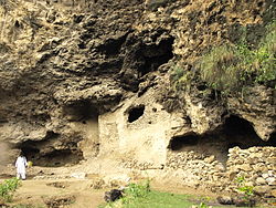 The caves at Shah Allah Ditta, on Islamabad's outskirts, were part of an ancient Buddhist monastic community
 -
 The restored village of Saidpur predates the surrounding city of Islamabad


Construction and development
[edit]When Pakistan gained independence in 1947, the southern port city of Karachi was its provisional national capital. In 1958, a commission was constituted to select a suitable site near Rawalpindi for the national capital with particular emphasis on location, climate, logistics, and defence requirements, along with other attributes. After extensive study, research, and a thorough review of potential sites, the commission recommended the area northeast of Rawalpindi in 1959 which was used as provisional capital from that year on.[28][29] In the 1960s, Islamabad was constructed as a forward capital for several reasons.[30] Karachi was also located at the southern end of the country along the Arabian Sea. Pakistan needed a capital that was easily accessible from all parts of the country.[28][31] Karachi, a business centre, was also considered unsuitable partly because of intervention of business interests in government affairs.[32] The newly selected location of Islamabad was closer to the army headquarters in Rawalpindi and the Pakistani-administered sectors of the disputed Kashmir in the north.[24]
A Greek firm of architects, led by Konstantinos Apostolos Doxiadis, designed the master plan of the city based on a grid plan which was triangular in shape with its apex towards the Margalla Hills. Islamabad was touted by Pakistani legislators as their counterpart to Chandigarh, whose modernism they envied and with which it shares conceptual similarities.[33] The capital was not moved directly from Karachi to Islamabad; it was first shifted temporarily to Rawalpindi in the early 1960s and then to Islamabad when essential development work was completed in 1966.[34] In 1981, Islamabad separated from Punjab province to form Capital Territory. Such world-renowned architects as Edward Durell Stone and Gio Ponti have been associated with the city's development.[7]
Recent history
[edit]
Islamabad has attracted people from all over Pakistan, making it one of the most cosmopolitan and urbanised cities of Pakistan. As the capital city it has hosted numerous important meetings, such as the South Asian Association for Regional Cooperation summit in 2004.[35]
The city suffered damage from the 2005 Kashmir earthquake which had a magnitude of 7.6.[36] Islamabad has experienced a series of terrorist incidents including the July 2007 Siege of Lal Masjid (Red Mosque), the June 2008 Danish embassy bombing, and the September 2008 Marriott bombing.[37] In 2011, four terrorist incidents occurred in the city, killing four people, including the murder of the Punjab Governor Salmaan Taseer.[38]
Construction of the Rawalpindi-Islamabad Metrobus, the region's first mass transit line, began in February 2014 and was completed in March 2015. The Rawalpindi Development Authority built the project at a cost of approximately Rs. 24 billion, which was shared by both the Federal government and the provincial government of Punjab.[39]
Geography
[edit]-
 Satellite view of Islamabad-Rawalpindi Metropolitan Area with Margalla Hills in the north.
 -
 Margalla Hills, Islamabad
 -
 Islamabad's verdant cityscape merges with the Margalla Hills
 -
 Islamabad's lush landscape
 -
 Islamabad's deciduous trees change colours in autumn


Islamabad lies about 540 metres (1,770 ft) above sea level at the northern edge of the Pothohar Plateau and at the foot of the Margalla Hills in Islamabad Capital Territory.[40][41] The modern capital and the ancient Gakhar city of Rawalpindi form a conurbation and are commonly referred to as the Twin Cities.[42][32]
To the northeast of the city lies the colonial era hill station of Murree, and to the north lies the Haripur District of Khyber Pakhtunkhwa. Kahuta lies on the southeast, Taxila, Wah Cantt, and Attock District to the northwest, Gujar Khan, Rawat, and Mandrah on the southeast, and the metropolis of Rawalpindi to the south and southwest. Islamabad is located 120 kilometres (75 mi) southwest of Muzaffarabad, 185 kilometres (115 mi) east of Peshawar and 295 kilometres (183 mi) northwest of Lahore.
Islamabad covers an area of 906 square kilometres (350 sq mi).[43] A further 2,717 square kilometres (1,049 sq mi) area is known as the Specified Area, with the Margala Hills in the north and northeast. The southern portion of the city is an undulating plain. It is drained by the Kurang River, on which the Rawal Dam is located.[7]
Climate
[edit]
Islamabad has a humid subtropical climate (Köppen: Cwa), with five seasons: Winter (November–February), Spring (March and April), Summer (May and June), Rainy Monsoon (July and August) and Autumn (September and October). The hottest month is June, where average highs routinely exceed 38 °C (100.4 °F). The wettest month is July, with heavy rainfalls and evening thunderstorms with the possibility of cloudburst and flooding. The coolest month is January.
Islamabad's micro-climate is regulated by three artificial reservoirs: Rawal, Simli, and Khanpur Dam. The latter is located on the Haro River near the town of Khanpur, about 40 kilometres (25 mi) from Islamabad. Simli Dam is 30 kilometres (19 mi) north of Islamabad. 220 acres (89 ha) of the city consists of Margalla Hills National Park. Loi Bher Forest is situated along the Islamabad Highway, covering an area of 1,087 acres (440 ha).[44] The highest monthly rainfall of 743.3 mm (29.26 in) was recorded during July 1995.[45] Winters generally feature dense fog in the mornings and sunny afternoons. In the city, temperatures stay mild, with snowfall over the higher-elevation points on nearby hill stations, notably Murree and Nathia Gali. The temperatures range from 13 °C (55 °F) in January to 38 °C (100 °F) in June. The highest recorded temperature was 46.6 °C (115.9 °F) on 23 June 2005 while the lowest temperature was −6.0 °C (21.2 °F) on 17 January 1967.[46][47] Light snowfall sometimes happens on the peaks of the hills visible from the city, though this is rare.[48] Snowfall does not occur in the city itself. On 23 July 2001, Islamabad received a record-breaking 620 mm (24 in) of rainfall in just 10 hours. It was the heaviest rainfall in Islamabad in the past 100 years and the highest rainfall in 24 hours as well.[49][50] Water supply is strained, leading to project proposals like the Ghazi Barotha water supply project.
| Climate data for Islamabad (1991-2020) | |||||||||||||
|---|---|---|---|---|---|---|---|---|---|---|---|---|---|
| Month | Jan | Feb | Mar | Apr | May | Jun | Jul | Aug | Sep | Oct | Nov | Dec | Year |
| Record high °C (°F) | 30.1 (86.2) |
30.0 (86.0) |
37.0 (98.6) |
44.0 (111.2) |
45.6 (114.1) |
46.6 (115.9) |
45.0 (113.0) |
42.0 (107.6) |
38.1 (100.6) |
38.0 (100.4) |
32.2 (90.0) |
28.3 (82.9) |
46.6 (115.9) |
| Mean daily maximum °C (°F) | 17.7 (63.9) |
20.0 (68.0) |
24.8 (76.6) |
30.6 (87.1) |
36.1 (97.0) |
38.3 (100.9) |
35.4 (95.7) |
33.9 (93.0) |
33.4 (92.1) |
30.9 (87.6) |
25.4 (77.7) |
20.4 (68.7) |
28.9 (84.0) |
| Daily mean °C (°F) | 10.7 (51.3) |
13.4 (56.1) |
18.1 (64.6) |
23.6 (74.5) |
28.7 (83.7) |
31.4 (88.5) |
30.1 (86.2) |
29.1 (84.4) |
27.6 (81.7) |
23.3 (73.9) |
17.3 (63.1) |
12.5 (54.5) |
22.2 (72.0) |
| Mean daily minimum °C (°F) | 3.6 (38.5) |
6.8 (44.2) |
11.4 (52.5) |
16.6 (61.9) |
21.5 (70.7) |
24.5 (76.1) |
24.9 (76.8) |
24.2 (75.6) |
21.7 (71.1) |
15.6 (60.1) |
9.1 (48.4) |
4.7 (40.5) |
15.4 (59.7) |
| Record low °C (°F) | −6 (21) |
−5.0 (23.0) |
−3.8 (25.2) |
2.1 (35.8) |
5.5 (41.9) |
13.0 (55.4) |
15.2 (59.4) |
14.5 (58.1) |
13.3 (55.9) |
5.7 (42.3) |
−0.6 (30.9) |
−2.8 (27.0) |
−6.0 (21.2) |
| Average precipitation mm (inches) | 55.2 (2.17) |
93.4 (3.68) |
95.2 (3.75) |
58.1 (2.29) |
39.9 (1.57) |
78.4 (3.09) |
310.6 (12.23) |
317.0 (12.48) |
135.4 (5.33) |
34.4 (1.35) |
17.7 (0.70) |
25.9 (1.02) |
1,261.2 (49.65) |
| Average precipitation days (≥ 1.0 mm) | 4.7 | 6.3 | 7.3 | 6.1 | 5.2 | 6.0 | 12.3 | 11.9 | 6.4 | 2.9 | 2.0 | 2.0 | 73.1 |
| Average relative humidity (%) | 67 | 63 | 62 | 52 | 42 | 44 | 68 | 76 | 67 | 62 | 63 | 66 | 61 |
| Mean monthly sunshine hours | 195.7 | 187.1 | 202.3 | 252.4 | 319.0 | 300.1 | 264.4 | 250.7 | 262.2 | 275.5 | 247.9 | 195.6 | 2,952.9 |
| Mean daily sunshine hours | 6.3 | 6.6 | 6.5 | 8.4 | 10.1 | 10.0 | 8.5 | 8.1 | 8.7 | 8.9 | 8.3 | 6.3 | 8.1 |
| Source 1: NOAA (sun, 1961-1990),[51][52] Deutscher Wetterdienst (humidity 1973-1990, daily sun 1961-1990)[53] | |||||||||||||
| Source 2: PMD (extremes)[54] | |||||||||||||
Cityscape
[edit]
Civil administration
[edit]The Islamabad Capital Territory (ICT) Administration, generally known as ICT Administration, is the civil administration as well as main law and order agency of the federal capital.
The local government authority of the city is the Islamabad Metropolitan Corporation (IMC) with some help from Capital Development Authority (CDA), which oversees the planning, development, construction, and administration of the city.[55][56] Islamabad Capital Territory is divided into eight zones: Administrative Zone, Commercial District, Educational Sector, Industrial Sector, Diplomatic Enclave, Residential Areas, Rural Areas and Green Area.[57] Islamabad city is divided into five major zones: Zone I, Zone II, Zone III, Zone IV, and Zone V. Out of these, Zone IV is the largest in area.[58] Zone I consists mainly of all the developed residential sectors while Zone II consists of the under-developed residential sectors. Each residential sector is identified by a letter of the alphabet and a number, and covers an area of approximately 2 km × 2 km (1+1⁄4 mi × 1+1⁄4 mi). The sectors are lettered from A to I, and each sector is divided into four numbered sub-sectors.[59]
| Zones in Islamabad | ||
|---|---|---|
| Zone | Area | |
| acres | km2 | |
| I | 54,958.25 | 222.4081 |
| II | 9,804.92 | 39.6791 |
| III | 50,393.01 | 203.9333 |
| IV | 69,814.35 | 282.5287 |
| V | 39,029.45 | 157.9466 |
| Source: | Lahore Real Estate[58] | |
Sectors
[edit]

Series A, B, and C are still underdeveloped. The D series has seven sectors (D-11 to D-17),[58] of which only sector D-12 is completely developed. This series is located at the foot of Margalla Hills.[57] The E Sectors are named from E-7 to E-17.[58] Many foreigners and diplomatic personnel are housed in these sectors.[57] In the revised Master Plan of the city, CDA has decided to develop a park on the pattern of Fatima Jinnah Park in sector E-14. Sectors E-8 and E-9 contain the campuses of Bahria University, Air University, and the National Defence University.[60][61][62] The F and G series contains the most developed sectors. F series contains sectors F-5 to F-17; some sectors are still under-developed.[58] F-5 is an important sector for the software industry in Islamabad, as the two software technology parks are located here. The entire F-9 sector is covered with Fatima Jinnah Park. The Centaurus complex is a major landmark of the F-8 sector.[57] G sectors are numbered G-5 through G-17.[58] Some important places include the Jinnah Convention Centre and Serena Hotel in G-5, the Lal Masjid in G-6, the Pakistan Institute of Medical Sciences, the largest medical complex in the capital, located in G-8,[57] and the Karachi Company shopping center in G-9.
The H sectors are numbered H-8 through H-17.[58] The H sectors are mostly dedicated to educational and health institutions. National University of Sciences and Technology covers a major portion of sector H-12.[57] The I sectors are numbered from I-8 to I-18. With the exception of I-8, which is a well-developed residential area, these sectors are primarily part of the industrial zone. Two sub-sectors of I-9 and one sub-sector of I-10 are used as industrial areas. CDA is planning to set up Islamabad Railway Station in Sector I-18 and Industrial City in sector I-17.[57] Zone III consists primarily of the Margalla Hills and Margalla Hills National Park. Rawal Lake is in this zone. Zone IV and V consist of Islamabad Park, and rural areas of the city. The Soan River flows into the city through Zone V.[58]

Islamabad–Rawalpindi metropolitan area
[edit]When the master plan for Islamabad was drawn up in 1960, Islamabad and Rawalpindi, along with the adjoining areas, was to be integrated to form a large metropolitan area called Islamabad/Rawalpindi Metropolitan Area. The area would consist of the developing Islamabad, the old colonial cantonment city of Rawalpindi, and Margalla Hills National Park, including surrounding rural areas.[63][64] However, Islamabad city is part of the Islamabad Capital Territory, while Rawalpindi is part of Rawalpindi District, which is part of province of Punjab.[65]
Initially, it was proposed that the three areas would be connected by four major highways: Murree Highway, Islamabad Highway, Soan Highway, and Capital Highway. However, to date only two highways have been constructed: Kashmir Highway (the former Murree Highway) and Islamabad Highway.[64] Plans of constructing Margalla Avenue are also underway.[66] Islamabad is the hub all the governmental activities while Rawalpindi is the centre of all industrial, commercial, and military activities. The two cities are considered sister cities and are highly interdependent.[63]
-
 Aerial view of The Centaurus
 -

-
 Star and Crescent Monument near the start of Shakarparian
 -
 Sunset over the Lake View Park
 -
 Blue Area, the commercial hub of the city.
 -

-


Architecture
[edit]

Islamabad's architecture is a combination of modernity and old Islamic and regional traditions. The Saudi-Pak Tower is an example of the integration of modern architecture with traditional styles. The beige-coloured edifice is trimmed with blue tile works in Islamic tradition, and is one of Islamabad's tallest buildings. Other examples of intertwined Islamic and modern architecture include Pakistan Monument and Faisal Mosque. Other notable structures are: Secretariat Complex designed by Gio Ponti, Prime Minister's secretariat based on Mughal architecture and the National Assembly by Edward Durell Stone.[29]
The murals on the inside of the large petals of Pakistan Monument are based on Islamic architecture.[67] The Shah Faisal Mosque is a fusion of contemporary architecture with a more traditional large triangular prayer hall and four minarets, designed by Vedat Dalokay, a Turkish architect and built with the help of funding provided by King Faisal of Saudi Arabia.[68] The architecture of Faisal Mosque is unusual as it lacks a dome structure. It is a combination of Arabic, Turkish, and Mughal architectural traditions.[69] The Centaurus is an example of modern architecture under construction in Islamabad. The seven star hotel was designed by WS Atkins PLC.The newly built Islamabad Stock Exchange Towers is another example of modern architecture in the city.[70]
Demographics
[edit]| Year | Pop. | ±% |
|---|---|---|
| 1972 | 77,000 | — |
| 1981 | 204,000 | +164.9% |
| 1998 | 529,180 | +159.4% |
| 2017 | 1,009,003 | +90.7% |
| 2023 | 1,108,872 | +9.9% |
| Source: [71][72][73][5] | ||
Language
[edit]According to 2023 Pakistani census, there are 1,154,540 Punjabi, 415,838 Pashto, 358,922 Urdu, 140,780 Hindko, 51,920 Kashmiri, 46,270 Saraiki, 21,362 Sindhi, 10,315 Balti, 7,099 Shina, 5,016 Koshistani, 4,503 Balochi, 1,095 Mewati, 668 Brahvi, 182 Kalasha and 64,734 others, of total 2,283,244 speakers in Islamabad Capital Territory.
Literacy
[edit]As of 2010, the majority of the population lies in the age group of 15–64 years, around 59.38%. Only 2.73% of the population is above 65 years of age; 37.90% is below the age of 15.[75] Islamabad has the highest literacy rate in Pakistan, at 88%.[76] 9.8% of the population has done intermediate education (equivalent to grades 11 and 12). 10.26% have a bachelor or equivalent degree while 5.2% have a master or equivalent degree.[77] The labour force of Islamabad is 185,213[78] and the unemployment rate is 15.70%.[79]
Religion
[edit]In the Islamabad Capital Territory, Islam is the largest religion in the city, with 95.55% of the population following it. Christianity is the second largest religion, with 4.26% of the population following it. The Christians are concentrated mainly in the urban areas. Hinduism is followed by 0.04% of the population according to the 2023 census.[80][81]
Economy
[edit]
Islamabad is a net contributor to the Pakistani economy, as whilst having only 0.8% of the country's population, it contributes 1% to the country's GDP.[82] Islamabad Stock Exchange, founded in 1989, is Pakistan's third largest stock exchange after Karachi Stock Exchange and Lahore Stock Exchange, and was merged to form Pakistan Stock Exchange. The exchange had 118 members with 104 corporate bodies and 18 individual members. The average daily turnover of the stock exchange is over 1 million shares.[83]
According to the World Bank's Doing Business Report of 2010, Islamabad was ranked as the best place to start a business in Pakistan.[84] Islamabad's businesses are Pakistan's most compliant for paying tax dues.[85] As of 2012[update], Islamabad LTU (Large Tax Unit) was responsible for Rs 371 billion in tax revenue, which amounts to 20% of all the revenue collected by Federal Board of Revenue.[86]
Islamabad has seen an expansion in information and communications technology with the addition two Software Technology Parks, which house numerous national and foreign technological and information technology companies. Awami Markaz IT Park houses 36 IT companies, while Evacuee Trust house 29 companies.[87] Islamabad will see its third IT Park by 2020, which will be built with assistance from South Korea.[88]
Culture
[edit]Islamabad is home to many settlers from other regions of Pakistan and has a cultural and religious diversity of considerable antiquity. Due to its location on the Pothohar Plateau, remnants of ancient cultures and civilisations such as Aryan, Soanian, and Indus Valley civilisation can still be found in the region. A 15th-century Gakhar fort, Pharwala Fort is located near Islamabad.[89] Rawat Fort in the region was built by the Gakhars in 16th century and contains the grave of the Gakhar chief, Sultan Sarang Khan.[89]
Saidpur village is supposedly named after Said Khan, the son of Sarang Khan. The 500-year-old village was converted into a place of Hindu worship by a Mughal commander, Raja Man Singh. He constructed a number of small ponds: Rama kunda, Sita kunda, Lakshaman kunda, and Hanuman kunda.[90] The region is home to a small Hindu temple that is preserved, showing the presence of Hindu people in the region. The shrine of Sufi mystic Pir Meher Ali Shah is located at Golra Sharif, which has a rich cultural heritage of the pre-Islamic period. Archaeological remains of the Buddhist era can also still be found in the region. The shrine of Bari Imam was built by the Mughal emperor Aurangzeb. Thousands of devotees from across Pakistan attend the annual Urs of Bari Imam. The event is one of the largest religious gatherings in Islamabad. In 2004, the Urs was attended by more than 1.2 million people.[91]
The Lok Virsa Museum in Islamabad preserves a wide variety of expressions of folk and traditional cultural legacy of Pakistan. It is located near the Shakarparian hills and boasts a large display of embroidered costumes, jewellery, musical instruments, woodwork, utensils and folkloristic objects from the region and other parts of Pakistan.[citation needed]
Tourism
[edit]
The Faisal Mosque, built in 1986, is an iconic cultural and religious landmark that attracts many tourists; both domestic and international due to its modern interpertation of Islamic architecture designed by the Turkish architect Vedat Dalokay,[92] as well as its location at the foothills of the Margalla Hills. The mosque was named after Faisal bin Abdul Aziz, the then-King of Saudi Arabia to honour him for his role in financing the construction of the mosque. The mosque itself can host up to 74,000 worshippers at a time[93] and its interior is decorated with Islamic calligraphy of verses from the Quran.
One of the landmarks for tourists is the Pakistan Monument built in 2007 located in Islamabad. This tourist attraction represents the patriotism and sovereignty of Pakistan. The design is shaped as a dome with petal-shaped walls that are engraved with arts portraying Pakistan's other tourist landmarks such as the Badshahi Mosque, Minar-e-Pakistan and Lahore Fort.

Islamabad holds some of Pakistan's most prestigious museums such as Lok Virsa Museum, Institute of Folk and Traditional Heritage Shakarparian Park and prominent galleries such as the National Art Gallery and Gallery 6.
The Islamabad Museum contains many relics and artifacts dating back to the Gandhara period of the region, an intriguing fusion of Buddhist and Graeco-Roman styles. The living culture of Islamabad and Pakistan is best explored at Lok Virsa Museum, as well as the Institute of Folk and Traditional Heritage in Shakarparian Park.
Islamabad is built upon civilisation and architecture that ranges from the 10th Century to the modern era. As Islamabad is situated on the Potohar Plateau, the remains of civilisation descending from stone-age era include the Acheulian and the Soanian traditions and these are tourist landmarks. Islamabad has an array of historic landmarks that reflect the Hindu civilisation that dates back to the 16th Century with examples such as Saidpur. Saidpur that is situated in Islamabad has progressed from a village to a sacred place that includes temples where the Hindu Mughal Commanders worshipped.[94]
Margalla Hills National Park is located in the North sector of Islamabad and is in close proximity to the Himalayas. The National Park is home to a range of wildlife, including Himalayan goral, Barking deer and leopards. Margalla Hills National Park also has accommodation and camping grounds for tourists.[citation needed]
Recreation
[edit]
Located in the city, the Faisal Mosque is the largest mosque in South Asia and the sixth–largest mosque in the world. Built in the year 1986, it was named after the late king of Saudi Arabia, Faisal Bin Abdul Aziz, who backed and financed the construction.

The most famous and oldest hiking track of Islamabad is Trail 3. It starts from the Margalla Road in sector F-6/3. Due to steep hills, the trail is exhausting to some extent. The course leads to the point where it goes up to the Viewpoint and is about a 30–50 minutes track. After the Viewpoint it continues for another easy-going 45 – 60 minutes and reaches the Pir Sohawa, where there are two restaurants for food, The Monal and La Montana. In total, it is approximately a one-hour and thirty minute walk.[95]
Shah Allah Ditta village is a centuries-old village and a union council of the Islamabad Capital Authority. The village is named after a dervish who belonged to the Mughal era. It is estimated to be 650 years old approximately. It is also home to ancient caves that reflects the previous civilisations. The 2500-year-old Buddhist caves at the foot of Margalla Hills are located in west of Taxila, east of Islamabad and in the central area of Khanpur. A spring, a pond and a garden still exist near the Shah Allah Ditta Caves. There are some banyan trees in the garden, while all other fruit trees are gone. The water from the same spring was used to irrigate the garden adjoining the caves. During the Mughal period, when India was the centre of Sufism originating from Arabia and Central Asia, a saint named Shah Allah Ditta stayed in this garden and was entombed here. The place formerly attributed to sadhus, monks, or jogis is today known for the famous Sufi Shah Allah Ditta. A short distance from these caves is also an ancient baoli (stepwell) in the village of Kanthila, which is said to have been built by Sher Shah Suri.[96]
Transport
[edit]
Aerial transport
[edit]Islamabad is connected to major destinations around the world and domestically through Islamabad International Airport (IIAP).[97] The airport is the largest in Pakistan and is located south-west of Islamabad. The new airport inaugurated on 20 April 2018, spreads over 19 square kilometers with 15 passenger boarding bridges. It also includes facilities to accommodate two double-decker Airbus A380s, 15 remote bays and 3 remote bays for Air cargo.[97]
Public transport
[edit]
The Rawalpindi-Islamabad Metrobus is a 83.6 km (51.9 mi) bus rapid transit system operating in the Islamabad-Rawalpindi metropolitan area. The Metrobus network's first phase was opened on 4 June 2015, and stretches 22.5 kilometres between Pak Secretariat, in Islamabad, and Saddar in Rawalpindi. The second stage stretches 25.6 kilometres between the Peshawar Morr Interchange and New Islamabad International Airport and was inaugurated on 18 April 2022.[98][99] On 7 July 2022, the Green Line and Blue Lines were added to this Metrobus network.[100] The system uses e-ticketing and an Intelligent Transportation System and is managed by the Punjab Mass Transit Authority. The metro buses are widely used for commuting purposes by the labour force and students.
Railway
[edit]Islamabad railway station is located in sector I-9 in Islamabad, Capital Territory, Pakistan. The station appears as Margala on the Pakistan Railways website.[101]
Private transport
[edit]People use private transport like Taxis, Careem, Bykea, Indrive and Yango for local journeys.
Roadways
[edit]M-2 Motorway is 367 km (228 mi) long and connects Islamabad and Lahore.[102] M-1 Motorway connects Islamabad with Peshawar and is 155 km (96 mi) long.[102] Islamabad is linked to Rawalpindi through the Faizabad Interchange, which has a daily traffic volume of about 48,000 vehicles.[103]
Education
[edit]
As of 2010, Islamabad boasts the highest literacy rate in Pakistan at 98%,[76] and has some of the most advanced educational institutes in the country.[104] A large number of public and private sector educational institutes are present here. The higher education institutes in the capital are either federally chartered or administered by private organisations and almost all of them are recognised by the Higher Education Commission of Pakistan. High schools and colleges are either affiliated with the Federal Board of Intermediate and Secondary Education or with the UK universities education boards, O/A Levels, or IGCSE. According to the Academy of Educational Planning and Management's report, in 2009 there were a total of 913 recognized institutions in Islamabad (31 pre-primary, 2 religious, 367 primary, 162 middle, 250 high, 75 higher secondary and intermediate colleges, and 26 degree colleges).[105] There are seven teacher training institutes in Islamabad with a total enrolment of 604,633 students and 499 faculty.[105]
The Gender Parity Index in Islamabad is 0.93 compared to the 0.95 national average. There are 178 boys-only institutes, 175 girls-only, and 551 mixed institutes in Islamabad.[105] Total enrolment of students in all categories is 267,992; 138,272 for boys and 129,720 for girls.[105] There are 16 recognized universities in Islamabad with a total enrolment of 372,974 students and 30,144 teachers.[105] Most of the top ranked universities; National University of Sciences and Technology, COMSATS Institute of Information Technology and Pakistan Institute of Engineering & Applied Sciences, also have their headquarters in the capital.[106] The world's second largest general university by enrolment, Allama Iqbal Open University is located in Islamabad for distance education. Other universities include Air University, Bahria University, Center for Advanced Studies in Engineering, Federal Urdu University of Arts, Science and Technology, Hamdard University, National University of Computer and Emerging Sciences, Capital University of Science & Technology, National Defence University, Shifa Tameer-e-Millat University, National University of Modern Languages, Iqra University, International Islamic University, Virtual University of Pakistan, Muhammad Ali Jinnah University, The University of Lahore, Abasyn University, and The Millennium University College.
Healthcare
[edit]
In 2008, Islamabad had the lowest rate of infant mortality in the country at 38 deaths per thousand compared to the national average of 78 deaths per thousand.[107] Islamabad has both public and private medical centres. The largest hospital in Islamabad is Pakistan Institute of Medical Sciences (PIMS) hospital. It was established in 1985 as a teaching and doctor training institute. PIMS functions as a National Reference Center and provides specialised diagnostic and curative services.[108] The hospital has 30 major medical departments.[109] PIMS is divided into five administrative branches. Islamabad Hospital is the major component with a 592-bed facility and 22 medical and surgical specialties.[110]
The Children's Hospital is a 230-bed hospital completed in 1985. It contains six major facilities: Surgical and Allied Specialties, Medical and Allied Specialties, Diagnostic Facilities, Operation Theatre, Critical Care (NICU, PICU, Isolation & Accident Emergency), and a Blood Bank.[111] The Maternal and Child Health Care Center is a training institute with an attached hospital of 125 beds offering different clinical and operational services.[112] PIMS consists of five academic institutes: Quaid-e-Azam Postgraduate Medical College, College of Nursing, College of Medical Technology, School of Nursing, and Mother and Child Health Center.[113]
PAEC General Hospital and teaching institute, established in 2006, is affiliated with the Pakistan Atomic Energy Commission.[114] The hospital consists of a 100-bed facility[114] and 10 major departments: Obstetrics and Gynecology, Pediatric, General Medicine, General Surgery, Intensive Care Unit/Coronary Care Unit, Orthopedics, Ophthalmology, Pathology, Radiology, and Dental Department.[115] Shifa International Hospital is a teaching hospital in Islamabad that was founded in 1987 and became a public company in 1989. The hospital has 70 qualified consultants in almost all specialties, 150 IPD beds and OPD facilities in 35 different specialisations.[116] According to the Federal Bureau of Statistics of the Government of Pakistan, in 2008 there were 12 hospitals, 76 dispensaries, and five maternity and child welfare centers in the city with a total of 5,158 beds.[117]
Sports
[edit]

Islamabad has a multipurpose sports complex opposite Aabpara. It includes Liaquat Gymnasium for indoor games, Mushaf Squash Complex and Jinnah Sports Stadium for outdoor games, which is a venue for regular national and international events. 2004 SAF Games were held in the stadium. Some other sports venues of Islamabad include Diamond Club Ground, Shalimar Cricket Ground and Islamabad Golf Club.
There is another multipurpose sports complex in the F6 Markaz. It has tennis courts, a basketball court with fibre-glass boards and a Futsal ground which introduced artificial turf to the people of Islamabad.
Major sports in the city include cricket, football, squash, hockey, table tennis, rugby and boxing.[118] The city is home to Islamabad United[119] which won the first ever Pakistan Super League in 2016 and second title in 2018,[120][121] and Islamabad All Stars, which participates in the Super Kabaddi League.
Islamabad also has various rock climbing spots in the Margalla Hills.[122]
The Pakistan Sports Complex has three swimming pools for children. These facilities attract a large gathering on weekends.[123]
Twin towns and sister cities
[edit]Notes
[edit]- ^ This figure indicates the urban population of the Islamabad Tehsil.
- ^ Administrator system was implemented for 6 months before next local bodies election and Deputy Commissioner of Islamabad was given additional charge as administrator in absence of mayor on 28 October 2021.[2]
- ^ "Islāmābād, the name given by the emperor Awrangzīb [q.v.] to several towns in India, for reasons not precisely known... Of these Čittāgong ..., at the head of the Bay of Bengal, is still known occasionally in religious circles as Islāmābād, the official name remaining the original Čittāgong. Mathurā, on the river Yamunā,... was given the name Islāmābād... Amantnāg in the Kashmir valley... also received the name Islāmābād and is still known to the Muslims of the area by this name...The fort of Čākana, near Poona, ...was named Islāmābād after it had been taken by Awrangzīb’s general..."[19]
References
[edit]- ^ McGarr, Paul (2013). The Cold War in South Asia: Britain, the United States and the Indian subcontinent, 1945-1965. Cambridge University Press. ISBN 9781107008151. Archived from the original on 18 February 2023. Retrieved 24 December 2020.
- ^ "Hamaza Shafqat appointed Administrator MCI for 6 months". The Nation (newspaper). 28 October 2021. Archived from the original on 19 November 2021. Retrieved 5 January 2022.
- ^ "New DC Islamabad takes charge". Dawn. 19 April 2022.
- ^ "CDA Facts & Figures". Archived from the original on 9 January 2021. Retrieved 31 December 2017.
- ^ a b "Area, Population By Sex, Sex Ratio, Population Density, Urban Population, Household Size and Annual Growth Rate, Census–2023, Islamabad" (PDF). Pakistan Bureau Statistics. 5 August 2023. Archived (PDF) from the original on 15 March 2025. Retrieved 24 November 2023.
- ^ "Islamabad". Lexico UK English Dictionary. Oxford University Press. Archived from the original on 18 May 2021.
- ^ a b c "Islamabad". Encyclopædia Britannica. 23 May 2023. Archived from the original on 3 May 2015. Retrieved 23 June 2022.
- ^ "History and Heritage". ICT Administration. Archived from the original on 29 September 2023. Retrieved 24 September 2023.
- ^ Leslie Noyes Mass (15 September 2011). Back to Pakistan: A Fifty-Year Journey. Rowman & Littlefield Publishers. p. 170. ISBN 978-1442213197.
- ^ Ravi Kalia (21 April 2011). Pakistan: From the Rhetoric of Democracy to the Rise of Militancy. Pakistan: Routledge. p. 83. ISBN 978-0415670401.
- ^ "National Monument: Structure reflects history of Pakistan – The Express Tribune". The Express Tribune. 29 August 2013. Archived from the original on 28 October 2019. Retrieved 13 June 2016.
- ^ "The World According to GaWC 2020". GaWC - Research Network. Globalization and World Cities. Archived from the original on 24 August 2020. Retrieved 31 August 2020.
- ^ Hetland, Atle (23 March 2014). "Islamabad – a city only for the rich?". Dawn. Archived from the original on 24 September 2019. Retrieved 23 October 2016.
- ^ "G-12, a sector housing rich, poor alike". The Nation. Archived from the original on 17 August 2017. Retrieved 23 October 2016.
- ^ "Safe City Project gets operational: Islooites promised safety – The Express Tribune". The Express Tribune. 6 June 2016. Archived from the original on 7 June 2016. Retrieved 7 June 2016.
- ^ "Crime rate in Islamabad drops, claim police". The Nation. 28 March 2015. Archived from the original on 16 October 2017. Retrieved 7 June 2016.
- ^ Room, Adrian (13 December 2005). Placenames of the World. McFarland & Company. p. 177. ISBN 978-0786422487.
- ^ Heath, John E. (2017). Oxford Concise Dictionary of World Place Names (3rd ed.). Oxford University Press. ISBN 978-0-19-255646-2.
...the Pakistanis chose 'City of Islam' from the Arabic islām 'submission to God' and ābād. The city became the capital in 1967 and the area around it is known as the Federal Capital Area. Aurangzeb (1618–1707), Mughal emperor (1658–1707), gave this name to several towns in India.
- ^ Bazmee Ansari, A.S. (1997). "Islāmābād". In van Donzel, E.; Lewis, B.; Pellat, Ch. & Bosworth, C. E. (eds.). The Encyclopaedia of Islam, Second Edition. Volume IV: Iran–Kha. Leiden: E. J. Brill. p. 177. doi:10.1163/1573-3912_islam_SIM_3638. OCLC 758278456.
- ^ Capital Talk (6 February 2020). "Islamabad Ka Naam Kisney Rakha Tha, Qaum Be-Khabr Kyun?" [Who Named Islamabad, Why Is the Nation Unaware?] (Video) (in Urdu). Geo News. Archived from the original on 11 December 2021. Retrieved 26 June 2020 – via YouTube.
- ^ "اسلام آباد: پاکستان کے وفاقی دارالحکومت کا نام کس نے اور کیسے تجویز کیا؟" [Islamabad: Who suggested the name of the federal capital of Pakistan and how?]. BBC Urdu. Archived from the original on 24 February 2022. Retrieved 26 February 2022.
- ^ a b Pakistan Defence Ministry. "Potohar". Archived from the original on 6 November 2010. Retrieved 29 August 2009.
- ^ "Sacred rocks of Islamabad". Dawn. 2 August 2009. Archived from the original on 7 August 2009. Retrieved 27 June 2010.
- ^ a b c d "Islamabad history". Pakistan.net. Archived from the original on 30 June 2008.
- ^ LEAD. "Background on the Potohar Plateau". Archived from the original on 20 July 2011.
- ^ "Saidpur Village – a witness to history". The Express Tribune. 27 March 2016. Archived from the original on 18 January 2022. Retrieved 21 May 2023.
- ^ Amjid, Iqbal (29 February 2016). "Taxila: Mughal-era coin & 'longest staircase' unearthed near Ban Faqiran". Dawn.
- ^ a b "New Orient". Czechoslovak Society for Eastern Studies. 4–6. Prague: 565. 1965. ISSN 0548-6408. OCLC 2264893.
- ^ a b Jonathan M. Bloom; Sheila Blair, eds. (23 March 2009). The Grove Encyclopedia of Islamic Art & Architecture. USA: Oxford University Press. p. 309. ISBN 978-0195309911.
- ^ "City of Islamabad". Capital Development Authority, Govt. of Pakistan. Archived from the original on 12 October 2014. Retrieved 17 October 2014.
- ^ Barbara A. Weightman (15 March 2011). Dragons and Tigers: A Geography of South, East, and Southeast Asia (3rd ed.). Wiley. p. 146. ISBN 978-0470876282.
- ^ a b Wolfgang Saxon (11 April 1988). "New Capital City With an Industrial Twin". The New York Times. Archived from the original on 9 May 2013. Retrieved 1 July 2012.
- ^ Daechsel, Markus (2015). Islamabad and the Politics of International Development in Pakistan. Cambridge University Press. pp. 221–223. ISBN 9781107298033.
- ^ Maneesha Tikekar (1 January 2004). Across the Wagah: An Indian's Sojourn in Pakistan. Promilla. pp. 23–62. ISBN 978-8185002347.
- ^ DAWN News (4 January 2004). "Islamabad making history". Archived from the original on 13 October 2008. Retrieved 29 September 2009.
- ^ "Quake's terrible toll is revealed". BBC News. 9 October 2005. Archived from the original on 24 February 2007. Retrieved 5 May 2010.
- ^ OhmyNews. "Timeline of Suicide Blasts in Islamabad". Archived from the original on 19 January 2012. Retrieved 25 October 2009.
- ^ Munawer Azeem (5 January 2012). "Islamabad saw four terror attacks last year". Dawn. Islamabad. Archived from the original on 17 January 2013. Retrieved 2 July 2012.
- ^ "Shahbaz to inaugurate work on Metro Bus Service on Feb 28". Dawn. 28 January 2014. Archived from the original on 4 March 2016. Retrieved 14 March 2016.
- ^ Stanley D. Brunn; Jack F. Williams; Donald J. Zeigler (2003). "Cities of South Asia". Cities of the World: World Regional Urban Development (3rd ed.). Rowman & Littlefield Publishers. pp. 368–369. ISBN 978-0847698981.
- ^ "Islamabad Airport". Climate Charts. Archived from the original on 22 July 2009. Retrieved 28 August 2009.
- ^ Yasmeen Niaz Mohiuddin (27 November 2006). Pakistan: A Global Studies Handbook (1st ed.). ABC-CLIO. p. 299. ISBN 978-1851098019. Retrieved 1 July 2012.
- ^ Butt, M. J., Waqas, A., Iqbal, M, F., Muhammad., G., and Lodhi, M. A. K., 2011, "Assessment of Urban Sprawl of Islamabad Metropolitan Area Using Multi-Sensor and Multi-Temporal Satellite Data." Arabian Journal For Science and Engineering. Digital Object Identifier (DOI): 10.1007/s13369-011-0148-3.
- ^ "Urban growth monitoring along Islamabad Highway". GIS Development. Archived from the original on 24 September 2015. Retrieved 29 August 2009.
- ^ "Climate Records: Islamabad". Archived from the original on 12 January 2012. Retrieved 14 January 2012.
- ^ "Best Housing Societies in Islamabad to Invest in 2022". 13 June 2010. Archived from the original on 13 June 2010. Retrieved 15 January 2012.
- ^ "Average Conditions, Islamabad, Pakistan". Archived from the original on 13 February 2006. Retrieved 25 September 2009.
- ^ "Margalla hills receive snowfall after decade". 11 February 2016. Archived from the original on 30 September 2021. Retrieved 30 September 2021.
- ^ "Severe Storms on dated 23rd July 2001 Islamabad, Pakistan" (PDF). Abdul Hameed, Director Pakistan Meteorological Department. Archived (PDF) from the original on 29 February 2012. Retrieved 21 July 2009.
- ^ "Weather Log – July 21–31, 2001". National Climatic Data Center. 6 August 2001. Archived from the original on 24 March 2012. Retrieved 21 July 2009.
- ^ "Islamabad Climate Normals 1961-1990". National Oceanic and Atmospheric Administration. Retrieved 16 January 2012.
- ^ "Islamabad Climate Normals 1991–2020". World Meteorological Organization Climatological Standard Normals (1991–2020). National Oceanic and Atmospheric Administration. Retrieved 17 September 2023.
- ^ "Klimatafel von Islamabad (Flughafen) / Pakistan" (PDF). Federal Ministry of Transport and Digital Infrastructure. Retrieved 17 September 2016.
- ^ "Extremes of Islamabad". Pakistan Meteorological Department. Retrieved 1 February 2015.
- ^ Anis, Muhammad (2 March 2016). "70% CDA employees to be transferred to Islamabad Metropolitan Corporation". The Nation. Archived from the original on 19 September 2016. Retrieved 9 September 2016.
- ^ CDA Official site. "CDA". Archived from the original on 5 September 2009.
- ^ a b c d e f g "The Idea of Islamabad". TheIslamabad.com. Archived from the original on 10 September 2009. Retrieved 28 August 2009.
- ^ a b c d e f g h DHA Lahore. "Map of Islamabad". Archived from the original on 14 February 2010.
- ^ Matthew S. Hull (5 June 2012). Government of Paper: The Materiality of Bureaucracy in Urban Pakistan (1st ed.). University of California Press. p. 50. ISBN 978-0520272156. Retrieved 4 July 2012.
- ^ Bahria University. "Official website". Archived from the original on 1 March 2010.
- ^ Air University. "Official website". Archived from the original on 8 February 2010. Retrieved 26 September 2009.
- ^ National Defence University. "Official website". Archived from the original on 21 September 2021. Retrieved 25 September 2021.
- ^ a b Dulyapak Preecharushh (6 April 2011). "Myanmar's New Capital City of Naypyidaw". In Stanley D. Brunn (ed.). Engineering Earth: The Impacts of Megaengineering Projects (1st ed.). Springer. p. 1041. ISBN 978-9048199198.
- ^ a b Muhammad. "Planning of Islamabad and Rawalpindi" (PDF). Archived (PDF) from the original on 4 April 2023. Retrieved 28 August 2009.
- ^ Sheikh, Iqbal M.; Van S. Williams; S. Qamer Raza; Kanwar S.A. Khan. "Environmental Geology of the Islamabad-Rawalpindi Area, Northern Pakistan" (PDF). Regional Studies of the Potwar Plateau Area, Northern Pakistan. U.S. Department of the Interior, U.S. Geological Survey. Archived (PDF) from the original on 20 October 2023. Retrieved 28 August 2009.
- ^ "Margalla Avenue to benefit commuters of KPK, traffic on Kashmir Highway". OnePakistan. Archived from the original on 4 March 2016. Retrieved 7 October 2013.
- ^ National Monument — a symbol of unity Archived 15 January 2009 at the Wayback Machine. Daily Times. 30 March. Retrieved 23 March 2008
- ^ Allison Lee Palmer (12 October 2009). The A to Z of Architecture. Scarecrow Press. p. 149. ISBN 978-0810868953. Retrieved 1 July 2012.
- ^ Archnet. "Faisal Mosque". Archived from the original on 3 May 2011.
- ^ Islamabad Stock Exchange-Official Website. "Islamabad Stock Exchange Towers". Archived from the original on 4 February 2005.
- ^ Elahi, Asad (2006). "2: Population". Pakistan Statistical Pocket Book 2006. Statistics Division. Islamabad, Pakistan: Government of Pakistan. p. 28. Archived from the original (PDF) on 30 March 2018. Retrieved 29 March 2018.
- ^ "SALIENT FEATURES OF FINAL RESULTS CENSUS-2017" (PDF). Archived from the original (PDF) on 29 August 2021. Retrieved 20 May 2021.
- ^ DISTRICT WISE CENSUS RESULTS CENSUS 2017 (PDF) (Report). Pakistan Bureau of Statistics. 2017. p. 13. Archived from the original (PDF) on 29 August 2017. Retrieved 29 March 2018.
- ^ "TABLE 11 – POPULATION BY MOTHER TONGUE, SEX AND RURAL/ URBAN" (PDF). Pakistan Bureau of Statistics. Retrieved 20 July 2024.
- ^ Population Census Organization, Govt. of Pakistan. "POPULATION BY SELECTIVE AGE GROUPS" (PDF). Archived from the original (PDF) on 27 August 2010.
- ^ a b "Literacy Rate" (PDF). Pakistan Bureau of Statistics. Archived (PDF) from the original on 27 September 2013. Retrieved 22 September 2013.
- ^ Population Census Organization, Govt. of Pakistan. "Population by Level of Education". Archived from the original on 20 July 2009.
- ^ Population Census Organization, Govt. of Pakistan. "LABOR FORCE PARTICIPATION RATES" (PDF). Archived from the original (PDF) on 27 August 2010.
- ^ Population Census Organization, Govt. of Pakistan. "UN-EMPLOYMENT RATES" (PDF). Archived from the original (PDF) on 27 August 2010.
- ^ "Population by Sex, Religion and Rural/Urban, Census - 2023" (PDF). pbs.gov.pk. Pakistan Bureau Statistics.
- ^ Population Census Organization, Govt. of Pakistan. "POPULATION BY RELIGION" (PDF). Archived from the original (PDF) on 17 June 2006.
- ^ "Pakistan | Economics and extremism". Dawn. 5 January 2010. Archived from the original on 8 January 2010. Retrieved 2 June 2010.
- ^ ISE-Official website. "About ISE". Archived from the original on 17 June 2011.
- ^ "Faisalabad best place to do business in Pakistan". The Express Tribune. 30 June 2010. Archived from the original on 26 December 2017. Retrieved 25 December 2017.
- ^ "Doing Business in Islamabad". Doing Business. Doing Business (World Bank). 2010. Archived from the original on 25 December 2017. Retrieved 25 December 2017.
- ^ "Rs 371bn revenue target: FBR hails LTU Islamabad's performance". Business Recorder. 5 July 2012. Retrieved 9 July 2012.
- ^ Pakistan Software Export Board. "Islamabad". Archived from the original on 5 May 2010.
- ^ "Islamabad to get IT Park by 2020". The Express Tribune. 9 July 2017. Archived from the original on 26 December 2017. Retrieved 25 December 2017.
- ^ a b Ministry of Tourism, Government of Pakistan. "Forts of Pakistan". Archived from the original on 27 September 2009.
- ^ "Sidpur Village". The Daily Times. Archived from the original on 23 July 2012. Retrieved 30 August 2009.
- ^ Huma Khawar. "Spotlight Bari Imam". Dawn News. Archived from the original on 5 December 2008. Retrieved 30 August 2009.
- ^ Marian Rengel (2003). Pakistan. Internet Archive. Rosen Pub. Group. ISBN 978-0-8239-4001-1.
- ^ "Archnet: Faisal Mosque". Archnet.
- ^ "Archived copy". Archived from the original on 28 December 2017. Retrieved 8 March 2020.
{{cite web}}: CS1 maint: archived copy as title (link) - ^ "Hiking Trail 3". Archived from the original on 11 July 2018.
- ^ "Shah Allah Ditta caves – relic of ancient Buddhism". The Express Tribune. 9 June 2022. Archived from the original on 5 July 2022. Retrieved 24 February 2023.
- ^ a b Islamabad Airport. "Islamabad Airport". Islamabad Airport. Archived from the original on 17 July 2021. Retrieved 17 July 2021.
- ^ "Islamabad Starts Trial of Orange Line Metro Bus Service". INCPAK. 16 April 2022. Archived from the original on 28 June 2022. Retrieved 18 April 2022.
- ^ "PM Shehbaz Sharif confident his 'speedy work' will frighten ex-premier Imran Khan". GEO News. 18 April 2022. Archived from the original on 18 April 2022. Retrieved 18 April 2022.
- ^ "PM Shahbaz inaugurates Green Line, Blue Line metro bus services". The News International. 7 July 2022. Archived from the original on 14 August 2022. Retrieved 21 July 2022.
- ^ "Pakistan Railways". Pakistan Railways. Archived from the original on 1 February 2021. Retrieved 5 October 2022.
- ^ a b National Highway Authority Pakistan. "Motorway's of Pakistan". Archived from the original on 6 October 2022. Retrieved 17 September 2009.
- ^ NESPAK. "Faizabad Interchange". Archived from the original on 10 August 2011.
- ^ Charles S. Benson (1972). "New Cities and Educational Planning". In Dennis L. Roberts (ed.). Planning Urban Education: New Techniques to Transform Learning in the City. Educational Technology Publications. p. 111. ISBN 978-0877780243. Retrieved 3 July 2012.
- ^ a b c d e AEPAM. "Pakistan Education Statistics 2008–09" (PDF). Archived from the original (PDF) on 17 January 2013.
- ^ HEC, Pakistan. "HEC University Rankings by Category". Archived from the original on 27 February 2012.
- ^ TheNews website. "Punjab tops in infant mortality, poverty, income inequality". Archived from the original on 6 November 2013. Retrieved 27 December 2021.
- ^ PIMS-Official website. "About PIMS". Archived from the original on 27 December 2005.
- ^ PIMS-Official website. "Departments at PIMS". Archived from the original on 28 February 2014.
- ^ PIMS-Official website. "Islamabad Hospital". Archived from the original on 27 December 2005.
- ^ PIMS-Official website. "Children Hospital". Archived from the original on 15 September 2009.
- ^ PIMS-Official website. "Maternal & Child Health Care Center". Archived from the original on 1 November 2005.
- ^ PIMS-Official website. "Quaid-i-Azam Postgraduate Medical College". Archived from the original on 15 July 2005.
- ^ a b PAEC General Hospital-Official website. "About PAEC Hospital". Archived from the original on 6 January 2009.
- ^ PAEC General Hospital-Official website. "Functions of Major Departments". Archived from the original on 6 January 2009.
- ^ SHIFA International Hospital-Official website. "SHIFA History". Archived from the original on 23 April 2009.
- ^ Federal Bureau of Statistics. "Hospitals/Dispensaries and Beds by Province" (PDF). Archived from the original (PDF) on 13 November 2010.
- ^ M. Hanif Raza (1985). Islamabad and environs. Colorpix. p. 83. ASIN B0006ENJ0I.
- ^ Shafique, Adnan. "Islamabad United". Archived from the original on 24 February 2023. Retrieved 24 February 2023.
- ^ "ARY Digital Network President Salman Iqbal congratulates Islamabad United over winning PSL". ARY News. 24 February 2016. Archived from the original on 25 February 2016. Retrieved 24 February 2016.
- ^ "Ronchi, Shadab seal Islamabad's second PSL title". ESPNcricinfo. Archived from the original on 27 March 2019. Retrieved 25 March 2019.
- ^ Arran, John (2012). "A Guide to Climbing in Margalla" (PDF). Rock Climbing Islamabad. Pakistan Alpine Institute. Archived from the original (PDF) on 22 October 2013. Retrieved 12 October 2013.
- ^ "Sports facilities at Pakistan Sports Complex". Archived from the original on 8 May 2016.
- ^ "Twin towns of Minsk". Computer Centre of Minsk City Executive Committee. 2008. Archived from the original on 30 August 2009. Retrieved 8 December 2008.
- ^ Greater Amman Municipality-Official website. "Twin city agreements". Archived from the original on 14 December 2020.
- ^ a b c "The making of a slum city". The Express Tribune. 9 December 2016. Archived from the original on 8 November 2020. Retrieved 31 July 2020.
- ^ a b c "Islamabad to get new sister city". Dawn. 5 January 2016. Archived from the original on 18 March 2018. Retrieved 31 July 2020.
- ^ Greater Municipality of Ankara. "Sister Cities of Ankara". Archived from the original on 5 July 2010.
- ^ Beijing International-Official website. "Sister cities". Archived from the original on 26 May 2010. Retrieved 16 May 2015.
- ^ "Daily Times". Daily Times. Archived from the original on 29 July 2012. Retrieved 14 August 2018.
- ^ BeritaSatu.com. "KONI DKI Jalin Kerja Sama 'Sister City' dengan 21 Kota Dunia". beritasatu.com (in Indonesian). Retrieved 31 July 2020.[permanent dead link]
- ^ Abbas, Zaffar, ed. (5 January 2016). "Islamabad to get new sister city". Dawn. Karachi, Pakistan: Pakistan Herald Publications.
- ^ "Islamabad declared sister city of Minsk". The Nation. 5 January 2016. Archived from the original on 30 November 2020. Retrieved 31 July 2020.
- ^ Fazal Sher. "Islamabad, Seoul to be made sister cities". Daily Times. Archived from the original on 29 July 2012. Retrieved 16 May 2015.
- ^ Tambun, Lenny Tristia (26 June 2014). "KONI DKI Jalin Kerja Sama "Sister City" dengan 21 Kota Dunia". BeritaSatu (in Indonesian). Archived from the original on 1 February 2025. Retrieved 17 November 2025.
Bibliography
[edit]- Daechsel, Markus (2015). Islamabad and the Politics of International Development in Pakistan. New York: Cambridge University Press. ISBN 978-11-07-05717-3.
- Moatasim, Faiza (2023). Master Plans and Encroachments: The Architecture of Informality in Islamabad. University of Pennsylvania Press. ISBN 978-1-5128-2519-0.
- Nadiem, Ihsan H. (2006). Islamabad Pothohar, Taxila Valley and Beyond: History & Monuments. Sang-e-Meel Publications. ISBN 978-969-35-1904-4. OCLC 85891881.
- Yakas, Orestes (2001). Islamabad, The Birth of a Capital. Karachi: Oxford University Press. ISBN 0-19-579533-4.
External links
[edit] Definitions from Wiktionary
 Media from Commons
 News from Wikinews
 Quotations from Wikiquote
 Texts from Wikisource
 Textbooks from Wikibooks
 Resources from Wikiversity
 Travel information from Wikivoyage
 Data from Wikidata
- Official website
- Metropolitan Corporation Islamabad. Archived 17 July 2021 at the Wayback Machine.
 Geographic data related to Islamabad at OpenStreetMap

Islamabad
View on GrokipediaEtymology
Name Origins and Symbolism
The name Islamabad is a compound of two words: Islam, referring to the religion of Islam meaning "submission [to God]", and abad, a Persian and Urdu suffix denoting prosperity, habitation, or a place of abundance.[5][6] This etymology translates literally to "City of Islam" or "Abode of Islam", evoking an idealized settlement rooted in Islamic principles.[7] The name was coined in 1959 by Qazi Abdur Rehman Amritsari, a teacher and poet from Punjab, as part of proposals for the new federal capital site selected north of Rawalpindi.[8][9] It was finalized and approved by Pakistan's federal cabinet on February 24, 1960, under President Mohammad Ayub Khan, following review of various name suggestions to align with the nation's post-independence aspirations.[7][6] Symbolically, the nomenclature underscored Pakistan's identity as an Islamic Republic, established in 1956, intending to project a modern yet pious urban center that embodied ordered governance, moral rectitude, and communal prosperity under Islamic ethos—contrasting with the perceived limitations of Karachi as a provisional capital amid post-partition chaos.[8] This choice reflected first-principles nation-building efforts to forge a symbolic heartland fostering national unity and religious devotion, rather than secular or regionally inflected alternatives.[6]History
Pre-20th Century Settlement
Archaeological evidence indicates sparse human activity in the Islamabad region during prehistoric and ancient periods, primarily limited to temporary shelters in the Margalla Hills foothills due to the rugged terrain. Limestone caves at Shah Allah Ditta, located on the city's outskirts, show signs of habitation dating back potentially 2,800 years, with associations to ancient Buddhist monastic communities, though permanent settlements were minimal.[10][11] Stone Age artifacts and early settlement traces have been identified nearby, including at sites like Ban Faqiran, underscoring intermittent use rather than sustained urbanization, constrained by the hilly topography unsuitable for large-scale agriculture or infrastructure.[12] Medieval fortifications and villages emerged to control strategic passes like Margalla, facilitating trade routes between the Punjab plains and northern regions, yet population densities remained low. Pharwala Fort, constructed around the 11th century by the Gakhar clan near the Swaan River, served defensive purposes amid tribal conflicts, exemplifying the area's role in regional power dynamics rather than civilian habitation.[13][14] Saidpur Village, established in 1530 AD by Mirza Fateh Ali and later renamed after Sultan Said Khan, functioned as a small agrarian community with Mughal-era structures, reflecting localized settlement patterns without broader development.[15][16] Similarly, Shah Allah Ditta village, over 650 years old, supported modest pastoral and farming activities around its ancient caves.[10] Under British colonial administration from the mid-19th century, the Islamabad plateau formed part of Rawalpindi District, primarily utilized for peripheral military logistics supporting the Rawalpindi Cantonment, but lacked significant infrastructure or population growth. The terrain's defensibility via the Margalla Hills favored its selection for transient camps over permanent civilian expansion, with the area retaining a rural character dominated by scattered villages. Pre-1947 demographics highlight this sparsity, as the Potohar Plateau's villages sustained only limited inhabitants amid the dominant military focus on nearby Rawalpindi.[17][18]Selection as Capital and Initial Planning (1958–1960s)
In 1958, following his imposition of martial law, President Mohammad Ayub Khan decided to relocate Pakistan's capital from Karachi to a new site in the northern Punjab region near Rawalpindi, citing Karachi's peripheral location in the south—which hindered administrative centrality for a geographically divided nation spanning East and West Pakistan—as well as its vulnerability to naval threats and overcrowding from post-partition migration.[19] An eight-member commission was promptly formed to evaluate potential sites, recommending an area at the foot of the Margalla Hills for its strategic defensibility, cooler climate, and proximity to military installations in Rawalpindi, reflecting the military regime's emphasis on security over Karachi's established commercial infrastructure.[19][20] The Greek firm Doxiadis Associates, led by urban planner Constantinos Doxiadis, was commissioned in 1959 to develop the master plan, drawing inspiration from ancient city grids like those in Athens and adapting them to a modern sectoral layout divided into zones for residential, administrative, and commercial uses, with wide avenues and hierarchical sectors to promote orderly expansion.[21][22] The plan allocated extensive green belts and open spaces—intended to comprise over half the city's area—to enhance livability and separate urban functions, envisioning a garden city insulated from industrial sprawl.[22] In 1959, the name "Islamabad," meaning "City of Islam," was proposed by Qazi Abdur Rehman and adopted, with formal approval and groundbreaking occurring in 1960, marking the shift from conceptual design to initial site preparation under the Federal Capital Commission.[8][7] This top-down approach, reliant on foreign expertise, overlooked Pakistan's socioeconomic realities, including entrenched rural-urban divides and limited bureaucratic capacity under military rule, resulting in a design skewed toward elite administrative needs rather than accommodating broader population dynamics or local building traditions. Critics have noted that the idealistic emphasis on vast green zones and rigid zoning presumed stable governance and fiscal discipline absent in Pakistan's patronage-driven politics, fostering an exclusionary urban form that prioritized symbolic modernity for the ruling class while marginalizing lower-income groups from the outset. Such assumptions reflected Ayub Khan's developmentalist vision but ignored causal factors like informal land pressures and weak enforcement, setting the stage for later deviations from the plan's intent.[22]Construction Phase and Early Growth (1960s–1980s)
Construction of Islamabad commenced in the early 1960s following the approval of its master plan, with initial focus on developing core residential and administrative sectors such as F-6, F-7, G-6, and G-7.[23] These sectors featured low-density housing, wide avenues, and green spaces designed for government officials, marking the transition from barren land to a functional capital. By 1966, sufficient infrastructure allowed the official inauguration of Islamabad as Pakistan's capital, coinciding with the relocation of key federal institutions from Karachi.[24] This state-orchestrated migration primarily drew civil bureaucrats and military personnel, driving population growth from negligible levels in the late 1950s to approximately 204,000 by the 1981 census, reflecting engineered expansion rather than spontaneous urbanization.[25] The 1970s and 1980s saw accelerated infrastructure buildup, including roads, utilities, and public buildings, supported by federal funding amid Pakistan's military-led governance. A landmark achievement was the Faisal Mosque, funded by Saudi Arabia at a cost of over 120 million riyals, with construction from 1976 to 1986 under Turkish architect Vedat Dalokay's modernist design inspired by Bedouin tents and contemporary forms.[26] Upon completion, it became one of the world's largest mosques by prayer hall area, symbolizing Islamic solidarity and architectural ambition in the nascent capital.[27] Water supply relied heavily on Rawal Dam, originally built in the 1960s for nearby Rawalpindi but extended to irrigate and sustain Islamabad's sectors, highlighting early dependencies on regional reservoirs that foreshadowed future scarcity pressures.[28] Implementation flaws emerged concurrently, as the elite-oriented zoning marginalized pre-existing rural hamlets, relocating locals to peripheral areas like Sectors H and I-10 without equivalent amenities, prioritizing capital functions over inclusive growth.[29] This top-down approach, while enabling rapid elite settlement, limited organic economic diversification, with population influx tied to administrative relocation rather than broad-based opportunities, setting patterns of uneven development.[24]Post-Cold War Developments and Expansion (1990s–Present)
Following Pakistan's economic liberalization in the 1990s, private housing societies proliferated in Islamabad's peripheries, driven by demand for upscale residential options amid population influx and limited public sector capacity. Developments like Bahria Town, established in the late 1990s, introduced large-scale gated communities with modern amenities, marking a shift from state-led planning to market-driven expansion.[30] The Defence Housing Authority (DHA) Islamabad, formalized in 2005, further accelerated this trend by allocating military-managed lands for affluent housing, contributing to suburban sprawl beyond the original master plan's boundaries.[31] Infrastructure investments in the 2010s addressed connectivity strains from metropolitan growth. The Rawalpindi-Islamabad Metro Bus system launched on June 4, 2015, spanning 22.5 kilometers with dedicated lanes to alleviate traffic between the twin cities, serving over 125,000 daily passengers by 2017.[32] [33] The new Islamabad International Airport became operational on May 3, 2018, replacing the outdated Benazir Bhutto facility and handling increased air traffic with modern terminals designed for 15-25 million passengers annually.[34] Recent real estate surges in extensions like B-17 and DHA Valley reflect spillover from national economic recovery, with Pakistan's GDP growing 2.5% in FY2024 and projected at 2.7% for FY2025.[35] B-17, a CDA-approved sector, saw renewed investment in 2025 amid recovering markets, while DHA Valley advanced residential allotments for 5- and 8-marla plots.[36] [37] However, these expansions have strained the 1960s master plan, prompting a 2024 review amid overcapacity and rapid urbanization; experts note the blueprint's inadequacy for current unruly growth, including delayed revisions due to federal indecision as of December 2024.[38] [39] Unplanned developments have eroded green spaces, with a SUPARCO survey in December 2024 revealing widespread encroachments and building violations on CDA lands, corroborated by satellite analyses showing urban expansion rates exceeding 4% annually in recent decades.[40] Land use/cover studies from 1992-2012 indicate significant conversion of vegetation to built-up areas, with projections of 49% urban increase by 2035 from 2000 baselines, underscoring failures in enforcement against illegal settlements that prioritize short-term gains over sustainable planning.[41] [42] ![Rawalpindi-Islamabad Metro Bus system][float-right]![Satellite view of Islamabad-Rawalpindi Metropolitan Area illustrating urban sprawl][center]
Geography
Topography and Location
Islamabad is located at approximately 33°43′N 73°04′E on the northern edge of the Pothohar Plateau in the federally administered Islamabad Capital Territory, which encompasses 906 km².[43] The city sits at an average elevation of 540 meters above sea level, directly at the foot of the Margalla Hills, a series of Himalayan foothills extending northward and reaching peaks up to 1,604 meters.[44][45] This topography positions the urban area adjacent to rugged terrain that serves as a natural northern barrier, contributing to the site's selection for defensibility against land incursions while its inland location, distant from seaports, reduces exposure to naval threats.[44] The planned capital's proximity to Rawalpindi, about 14 km to the south, integrates it into a metropolitan continuum, with the hills delineating a transition from plateau lowlands to elevated slopes.[46] However, the steep gradients of the Margalla Hills channel runoff toward lower elevations during heavy precipitation, heightening flash flood risks in foothill-adjacent sectors, as demonstrated by the July 2025 torrent that inundated Saidpur village and swept away vehicles following 150 mm of rain.[47][48] Urban expansion since the 1960s has amplified localized heat retention, with studies documenting a 1.1°C increase in annual maximum land surface temperatures from 2000 to 2020, driven by built-up area growth encroaching on vegetated zones and exacerbating heat island dynamics amid the encircling topography.[49] This effect underscores dependencies on hillside ecosystems for moderating microclimates, though seismic activity in the broader Himalayan collision zone poses ongoing ground stability challenges not mitigated by the site's plateau foundation.[50]Climate Patterns
Islamabad features a humid subtropical climate classified as Cwa under the Köppen-Geiger system, marked by distinct seasonal shifts rather than uniform mildness.[51] Average annual precipitation totals around 1,142 mm, with roughly 60-80% concentrated in the monsoon period from late June to September, when heavy downpours can exceed 200 mm monthly in peak years.[52] [53] Summers (May to August) bring intense heat, with average highs of 33-38°C and peaks occasionally surpassing 40°C, as during the 2023 pre-monsoon heatwave that hit 39°C before rains provided temporary relief.[54] [55] Winters (December to February) are cooler and drier, with average lows dipping to 5-6°C and rare frosts, though daytime highs seldom fall below 20°C. For example, on February 19, 2026, typical winter weather patterns featured sunny to hazy sunshine conditions, with temperatures ranging from a low of 11-17°C (51-63°F) to a high of 26-27°C (79-81°F), current readings around 22-24°C (72-76°F) feeling like 25-27°C (77-81°F), light winds of 5-9 mph, and humidity of 36-43%.[53] Dense fog often blankets the region from November to February due to temperature inversions, leading to widespread transport disruptions including flight cancellations at Islamabad International Airport, slowed highway traffic on routes like the M-1 motorway, and delayed rail services.[56] [57] These patterns underscore climatic variability over any "garden city" ideal of consistent moderation; historical records indicate summer heat indices can approach survivability limits during prolonged dry spells, while monsoon variability has shown both deficits and excesses, with annual totals fluctuating 20-30% around the mean based on observational data from 1980 onward.[52] Urban expansion has amplified local extremes, such as elevated nighttime lows and intensified fog persistence, per meteorological analyses.[58]Environmental Degradation and Resource Strain
Islamabad faces acute water scarcity, primarily reliant on Simly and Rawal dams for supply, with levels in these reservoirs dropping sharply due to prolonged dry spells and high evaporation rates as of 2025.[59][60] The city's daily water demand stands at 283 million gallons, but shortages exceed 40% amid distribution losses and insufficient storage, exacerbated by a population that has more than doubled over the past two decades.[61][62] Illegal groundwater extraction through over 50,000 unregulated boreholes and commercial hydrants has accelerated depletion at rates of 5 to 8 feet annually, driven by weak enforcement and a thriving tanker mafia.[63][64][65] Air pollution in Islamabad has intensified, with PM2.5 concentrations reaching 133 μg/m³ in winter, far exceeding WHO limits, and an Air Quality Index peaking at 250 in December 2024.[66][67] Vehicular emissions account for 40-45% of pollutants, compounded by dust from ongoing construction projects that lack adequate mitigation measures.[68] Rapid urbanization tied to population growth has overwhelmed infrastructure, leading to persistent smog episodes despite the city's planned origins emphasizing sustainability.[69] Deforestation in the Margalla Hills National Park has accelerated, with 146 fires destroying approximately 3,000 trees over the last three years as of 2025, alongside encroachments and illegal logging eroding green cover.[70] Islamabad has lost about 36% of its forest and green areas since 2000, contrasting the original master plan's vision of preserved natural buffers, due to unchecked urban expansion and poor regulatory enforcement.[71][72] This habitat loss, linked directly to population pressures, diminishes ecological services like water retention and air purification, amplifying resource strains.[73]
Urban Planning and Cityscape
Administrative Divisions and Governance Structure
The Capital Development Authority (CDA) serves as the primary body responsible for the planning, development, and management of Islamabad, established on June 14, 1960, through an executive order known as the Pakistan Capital Regulation.[74] This autonomous federal agency oversees urban infrastructure, land use, and municipal services within the Islamabad Capital Territory (ICT), which encompasses 906.5 square kilometers and operates without provincial autonomy.[75] The CDA's mandate emphasizes master-planned growth, enforcing zoning and building regulations to maintain the city's designed layout, though its centralized authority has been critiqued for bureaucratic delays in service delivery.[76] In contrast to typical provincial districts, the ICT falls under direct federal administration, with the President of Pakistan holding ultimate responsibility for governance as stipulated in Article 258 of the Constitution.[77] Day-to-day oversight is provided by the ICT Administration, led by a Chief Commissioner who exercises powers akin to a provincial government under Presidential Order No. 18 of 1980, ensuring alignment with national priorities but subordinating local decision-making to federal directives.[77] This structure, while fostering coordinated development in a capital city, inherently limits decentralized responsiveness, as local issues must navigate federal hierarchies, often resulting in rigidity amid rapid urbanization pressures. Local input is facilitated through union councils established under the Islamabad Capital Territory Local Government Act, 2013, which divide the territory into sub-units for grassroots administration, including elected representatives handling community-level services like sanitation and dispute resolution.[78] These councils provide a mechanism for citizen engagement, yet their authority remains constrained by overriding federal and CDA controls, reflecting a hybrid model where centralized oversight prioritizes strategic order over agile local governance. Critics, including affected residents, contend this setup enables elite capture in land and resource decisions, as evidenced by persistent disputes over allocations that favor influential networks rather than equitable distribution.[79] Recent developments from 2023 to 2025 have seen efforts to address these tensions through CDA reforms, including the Capital Development Authority (Amendment) Ordinance, 2025, signed by President Asif Ali Zardari on May 3, 2025, which revises land acquisition procedures to include non-cash compensation options and enhanced protections for landowners, aiming to curb arbitrary grabs.[80] These changes followed probes into fraudulent transfers and encroachments, with Prime Minister Shehbaz Sharif forming a seven-member committee on September 18, 2025, to investigate land grabbing and recommend accountability measures.[79] Such reforms underscore the causal link between centralized control—effective for initial planning but prone to capture—and the need for procedural safeguards, though implementation challenges persist, as seen in unrolled initiatives like pre-approved building plans from 2023 decisions.[81]Sectoral Layout and Zoning
Islamabad's urban layout follows a grid-based system dividing the city into over 100 sectors across five zones, designed to separate residential, commercial, diplomatic, and other functions. Sectors are alphanumeric, ranging from A to I and numbered 5 to 17, with Zone I encompassing core areas like F and G series for urban development.[82] This zoning allocates specific areas for distinct uses, such as residential sectors like F-6, known for upscale housing favored by high-income residents and diplomats.[83] Commercial activities concentrate in the Blue Area, a central district along Jinnah Avenue serving as the primary business hub with malls, offices, and financial institutions.[84] The Diplomatic Enclave in G-5 houses over 40 foreign missions in a secure, restricted zone.[85] Such functional segregation, while promoting orderly growth, has fostered socioeconomic division, with property values in elite sectors like F-6 far exceeding those in peripheral areas; for instance, demolishable houses in F-6 can exceed PKR 7 crore for 444 square yards, pricing out lower-income groups.[86] This rigid zoning causally reinforces inequality by limiting mixed-income development and concentrating amenities in affluent zones, leading to spatial elitism unintended in the original planning but evident in price disparities spanning crores between core and outer sectors.[83] In the 2020s, deviations from the master plan include sprawling informal katchi abadis, unplanned settlements housing tens of thousands, such as over 8,000 residents in I-11 alone, comprising a significant unplanned population amid the grid's failure to accommodate rapid influxes.[87] These encroachments highlight the zoning's inflexibility, exacerbating sprawl and service strains outside formal sectors.[88]Architectural Features and Landmarks
Islamabad's architecture embodies the vision of Greek planner Constantinos Doxiadis, who designed the city in the 1960s as a low-rise, low-density administrative hub emphasizing horizontal expansion, green belts, and integration with the Margalla Hills to promote orderly growth and human-scale living.[89] This approach favored single-family homes and limited high-rise structures to preserve aesthetics and functionality, though it has faced criticism for constraining urban density amid population pressures.[90] Modern Islamic influences blend with functional modernism in key landmarks, yet persistent maintenance neglect—such as deteriorating facades and infrastructure—highlights a disconnect between monumental symbolism and practical upkeep.[91] The Faisal Mosque, completed in 1986, exemplifies contemporary Islamic design through its minimalist concrete form inspired by Bedouin tents and Mecca's Kaaba, eschewing traditional minarets and domes for four towering cylindrical supports.[92] Architect Vedat Dalokay's structure spans 5,000 square meters indoors, with a total capacity for approximately 300,000 worshippers including outdoor areas, making it one of the world's largest mosques upon opening.[92] Funded by Saudi Arabia and named after King Faisal, it serves as a national icon but has required ongoing repairs for weathering and seismic vulnerabilities, underscoring broader critiques of prioritizing grandeur over resilient maintenance in Pakistan's public architecture.[93] The Pakistan Monument, inaugurated on March 23, 2007, features a floral-shaped complex of four large petals representing Pakistan's provinces and azure wings symbolizing religious minorities, constructed from granite and concrete on a hilltop site for panoramic views.[94] Designed by Arif Masoud and Edward Safdie, the 2.8-hectare site includes a museum and gardens, costing around 450 million rupees, but its remote location and episodic upkeep have limited accessibility and drawn functional complaints amid urban housing deficits.[95] Government edifices like Parliament House, built in the 1970s with simple geometric lines and a central assembly hall, and the Supreme Court, completed in 1993 featuring a prominent dome and horizontal concrete masses, reflect modernist restraint suited to bureaucratic needs yet emblematic of Islamabad's institutional focus.[96] Recent additions, including the 2023 signing of Radisson Blu Hotel & Residences and Radisson Hotel Islamabad Multi Gardens—set for opening by 2026—and the Hilton Garden Inn announced that year with 115 rooms, signal a push toward tourism-oriented high-rise developments in commercial zones.[97][98] However, this monumental emphasis persists alongside acute housing shortages, with Pakistan facing a national deficit of over 10 million units, exacerbated in Islamabad by rigid zoning that favors elite plots over affordable mid-rise options for the urban poor.[99][100]Metropolitan Integration with Rawalpindi
Islamabad and Rawalpindi form a contiguous metropolitan area, commonly referred to as the twin cities, with a combined population exceeding 4.5 million residents.[101] This urban agglomeration relies on economic complementarity, where Rawalpindi's established industrial and commercial sectors—including oil refineries, factories producing iron and textiles, and military facilities—support Islamabad's concentration of federal government offices and administrative functions.[102] [17] The two cities exhibit strong social and economic ties, with daily cross-commuting for work, services, and trade underscoring their interdependence despite distinct historical developments.[103] Key physical linkages, such as the Islamabad-Jhelum Principal (IJP) Road—renamed Karnal Sher Khan Shaheed Road—facilitate connectivity between the urban cores, with major upgrades commencing in 2021 to widen the dual carriageway by adding lanes on both sides and incorporating computerized traffic signals.[104] [105] The project, largely completed by mid-2023, aimed to alleviate bottlenecks from Faizabad to the New Islamabad International Airport, yet persistent traffic congestion arises from mismatched zoning and uncoordinated growth patterns.[106] Commuters frequently experience delays of 11-40 minutes during peak hours due to overburdened intersections and inadequate signal synchronization across city boundaries.[107] Separate master plans for each city have perpetuated planning silos, hindering holistic metropolitan governance and exacerbating challenges like boundary overlaps and uneven infrastructure investment.[108] Federal priorities, which channel resources predominantly toward Islamabad as the capital, have intensified Rawalpindi's relative underdevelopment, fostering haphazard expansion and heightened congestion at integration points without addressing broader causal factors like population influx and limited inter-agency coordination.[109] [108] This bias contributes to Rawalpindi's role as a de facto service hub for Islamabad's workforce, straining its older urban fabric while limiting integrated solutions.[110]Demographics
Population Growth and Density
The population of Islamabad Capital Territory (ICT), encompassing the federal capital and surrounding areas, stood at approximately 2.0 million according to the 2017 census, with urban segments accounting for over 1.0 million residents.[42] By 2023, this figure had risen to 2.36 million per census data, reflecting an intercensal growth rate of about 4.8% in the preceding period, the highest among Pakistan's administrative units.[111] Projections for mid-2025 estimate the ICT population at 2.5 million, driven primarily by sustained net in-migration from rural regions and other urban centers attracted to the capital's administrative and service functions.[112] Annual population growth in Islamabad has averaged around 2.7% in recent years, with the urban core expanding by 34,340 residents between 2024 and 2025 alone.[101] This rate aligns with broader national trends of 2.55% but amplifies local pressures, as migration inflows—estimated to contribute over half of urban growth—outpace natural increase (births minus deaths).[113] [114] Empirical patterns indicate a causal chain wherein rural push factors, such as limited local services, combine with the capital's pull as a hub for governance and amenities, resulting in unplanned peripheral expansion beyond the city's zoned sectors. At 906 square kilometers, the ICT's population density reached 2,609 persons per square kilometer by 2023, concentrated heavily in urban zones where densities exceed 5,000 per square kilometer in core sectors.[111] [101] This marks a sharp rise from earlier decades, with built-up areas sprawling into ecologically sensitive foothills and agricultural peripheries due to unchecked settlement.[114] The original 1960s master plan envisioned a capacity of roughly 500,000 residents across low-density green sectors, but current densities overload water supply, sanitation, and transport networks, manifesting in empirical strains like overburdened reservoirs and informal housing proliferation.[42] Such dynamics underscore an unsustainable trajectory, where growth rates project further densification to 3 million by 2030 absent policy interventions.[115]Ethnic and Linguistic Diversity
According to the 2023 Pakistan census, Punjabi is the most widely spoken mother tongue in Islamabad, with 1,154,540 speakers comprising 50.57% of the population.[116][117] Pashto follows as the second largest group at approximately 416,000 speakers (18%), reflecting significant migration from Khyber Pakhtunkhwa and spillover from Afghan refugee movements. Urdu, historically prominent among early civil service migrants, accounts for 358,922 speakers (15.7%). Smaller shares include Hindko and Saraiki speakers, alongside minor groups such as Sindhi (21,362).[116][117][118] These figures proxy ethnic diversity, with Punjabi aligning with Punjabi/Pothohari groups from surrounding rural areas, Pashto with Pashtuns, and Urdu with Muhajir or cosmopolitan migrants. The post-2000s rise in Pashto speakers stems from conflict-driven displacement in northwest Pakistan and Afghanistan, including waves of Afghan refugees following the 2001 U.S. invasion and subsequent Taliban resurgence, which funneled Pashtun populations into urban centers like Islamabad for economic opportunities.[116][119] This influx has elevated the Pashtun linguistic share beyond 18%, with estimates from security analyses suggesting up to 25% when accounting for second-generation and undocumented movers, contributing to ethnic tensions over resource allocation in the capital.[120] The decline in Urdu's proportional share—from 21.79% in the 2017 census to 15.7% in 2023—indicates a relative erosion of dominance by Urdu-first elites, as broader low-skilled migration from provincial interiors dilutes the early post-independence bureaucratic demographic.[121][116] Pashto's growth, conversely, correlates with documented security risks; Pakistani authorities have linked urban Pashtun concentrations to militant infiltration, including Tehrik-i-Taliban Pakistan operatives exploiting migration networks for attacks in the capital, as evidenced by heightened intelligence operations and deportation drives targeting Afghan-linked Pashtuns.[120][119] Such shifts underscore causal pressures from regional instability on Islamabad's ethnic fabric, prioritizing empirical migration patterns over narrative equalization.Religious Composition and Practices
Islamabad's population is predominantly Muslim, with the 2017 national census recording 95.53% Muslims in the Islamabad Capital Territory, alongside 4.07% Christians and negligible Hindu (0.02%) and other minorities.[122] Among Muslims, Sunnis form the overwhelming majority, estimated nationally at 85-90%, while Shias constitute 10-15%, with local proportions in the capital likely similar due to urban migration patterns from diverse regions.[123] Christian communities, often comprising domestic workers and lower-income groups, maintain small pockets in sectors like G-9 and I-10, while Hindus and other non-Muslims remain minimal in number.[124] Islamic practices dominate daily life, with over 100 registered mosques serving the population, including prominent sites like the Faisal Mosque, which accommodates large congregations for Friday prayers and festivals such as Eid.[125] Adherence to five daily prayers is widespread among Muslims, supported by calls to prayer (azan) broadcast from minarets across sectors, though urban density and work routines influence participation rates. Madrasas, numbering in the dozens within and around the city, provide religious education, but empirical analyses link a subset of unregistered or fringe institutions to pathways of radicalization, particularly through curricula emphasizing sectarian interpretations over moderate fiqh, contributing to isolated extremism rather than systemic urban violence. Sectarian tensions have manifested in sporadic incidents, such as the 2009 suicide bombing near a Shia procession in the capital's outskirts and attacks in the 2010s targeting minority processions, resulting in dozens of casualties and highlighting vulnerabilities despite overall empirical coexistence in daily interactions.[126] These events, often perpetrated by groups like Lashkar-e-Jhangvi, underscore causal factors including ideological indoctrination in peripheral madrasas and retaliatory cycles, contrasting with narratives of pervasive intolerance; data indicate Islamabad experiences lower per-capita sectarian violence than provinces like Khyber Pakhtunkhwa, reflecting state security presence and urban pluralism.[127][128]Government and Politics
Role as Federal Capital
Islamabad functions as the federal capital of Pakistan, centralizing the nation's executive, legislative, and judicial branches. The Parliament House, located in the city's Red Zone, serves as the meeting place for the National Assembly and Senate, where federal legislation is debated and enacted.[4] Adjacent institutions include the Supreme Court of Pakistan, the apex judicial body responsible for constitutional interpretation and final appeals, and the Prime Minister's House, the official residence and workplace of the head of government.[4] [129] This concentration of power underscores Islamabad's administrative primacy, established when the city replaced Karachi as capital in 1960 to provide a more secure and planned governance hub amid geopolitical tensions.[4] The capital hosts over 80 diplomatic missions, including embassies and high commissions, primarily clustered in the Diplomatic Enclave in Sector G-5, facilitating Pakistan's international relations and foreign policy coordination.[130] This diplomatic density amplifies Islamabad's role in global engagements, with foreign representatives engaging directly with federal authorities on trade, security, and aid matters. However, the enclave's restricted access highlights security priorities driven by the site's sensitivity as the political nerve center. Economically, Islamabad's status generates substantial public sector employment and federal expenditures, positioning it as a net contributor to national output despite comprising less than 1% of Pakistan's population. Government-related activities, including bureaucratic operations and policy formulation, create multiplier effects through procurement, services, and infrastructure maintenance. Yet, this reliance on central funding—without robust local taxation or diversification—has drawn criticism for perpetuating dependency and rent-seeking, where economic incentives prioritize access to federal allocations over productive self-sufficiency. Analysts note that such over-centralization exacerbates bureaucratic inertia and inefficient resource distribution, as decision-making remains bottlenecked in the capital rather than devolved to provinces.[131] [132] Proposals to relocate the capital, as suggested by former officials, reflect frustrations with these structural inefficiencies, arguing for decentralization to foster broader national development.[131]Local Administration and Civic Bodies
The Capital Development Authority (CDA), established in 1960, functions as the principal civic body overseeing urban planning, infrastructure development, land allocation, and municipal services across Islamabad Capital Territory.[133] It maintains a monopoly on master planning, sector zoning, and estate management, including plot allotments and enforcement of building codes.[76] The CDA also handles maintenance of local roads, enforcement of environmental standards, and solid waste collection, though these responsibilities have faced persistent operational shortfalls amid rapid urbanization.[134] Complementing the CDA is the Islamabad Metropolitan Corporation (IMC), operationalized in recent years to manage day-to-day civic functions such as sanitation and local taxation, yet it remains subordinate to federal oversight and lacks independent authority over land matters.[135] Political appointments to CDA leadership, often influenced by federal executives, have contributed to governance inefficiencies, with empirical evidence from audits showing delayed project executions and unrecovered dues exceeding Rs225 million in fiscal irregularities as of 2024.[136] Corruption scandals, particularly in land allocation, have undermined the CDA's mandate, with 2024 federal audits exposing zoning violations in over 99 unauthorized housing societies and procedural lapses enabling fraudulent plot grants on non-existent or disputed land.[137] In one case, five CDA officials were arrested in April 2025 for a billion-rupee scheme involving the illicit allocation of 43 prime plots through abuse of authority.[138] Over 120 internal inquiries into officer misconduct remain unresolved, per audit reports, reflecting systemic delays exacerbated by interference and inadequate accountability mechanisms.[139] Civic service delivery lags behind population growth, notably in waste management, where open dumping and incomplete collection persist due to absent dedicated landfills and flawed outsourcing tenders criticized by federal ministers in June 2025.[140] Surveys indicate widespread community-level issues like unsegregated waste burning and inadequate infrastructure, straining resources in high-density sectors and highlighting the CDA's failure to scale operations despite annual budgets in the billions.[141] These deficiencies underscore broader governance vulnerabilities tied to politicized decision-making, as non-transparent auctions of plots worth Rs37.8 billion drew Auditor General scrutiny in November 2024 for procedural opacity and unaddressed recoveries.[142]Political Events, Protests, and Instability
Islamabad has experienced recurrent political sit-ins and protests since the 1990s, often stemming from national-level grievances such as disputed elections and leadership arrests, which expose tensions between federal power structures and opposition forces. These events frequently converge on the capital due to its symbolic role as the seat of government, leading to prolonged disruptions that reflect broader dissatisfaction with elite governance detached from public accountability. For instance, the 2014 Azadi March organized by Pakistan Tehreek-e-Insaf (PTI), led by [Imran Khan](/page/Imran Khan), protested alleged rigging in the 2013 general elections and lasted from August 14 to December 17, paralyzing central areas including Constitution Avenue with tens of thousands of participants.[143] [144] Concurrently, Pakistan Awami Tehreek's Inqilab March amplified the unrest, marking a record for extended demonstrations in Pakistan's history.[144] The arrest of former Prime Minister Imran Khan on May 9, 2023, outside the Islamabad High Court on corruption charges triggered immediate riots in the capital, with supporters clashing with security forces, resulting in at least 10 deaths and hundreds injured nationwide.[145] Authorities suspended internet services across Pakistan to curb the violence, which included attacks on military installations and government buildings in Islamabad.[146] Such episodes underscore causal links to partisan rivalries, where opposition mobilization exploits judicial actions against leaders to challenge the ruling coalition's legitimacy, often escalating into widespread instability. Islamist groups have contributed to frequent disruptions through sit-ins demanding enforcement of blasphemy laws or protesting perceived slights to religious sentiments, with Tehreek-e-Labbaik Pakistan (TLP) staging multiple marches to Islamabad since 2017 that have turned violent and blocked key routes.[147] In August 2025, the Capital Development Authority's (CDA) demolition of the Madni Mosque as an illegal encroachment near Rawal Dam sparked protests by Jamiat Ulema-i-Islam-Fazl (JUI-F) and other clerics, leading to clashes and threats of further agitation until officials agreed to reconstruction.[148] [149] A TLP protest in October 2025 halted economic activity in the Islamabad-Rawalpindi twin cities for days, causing flight delays at the international airport and broader losses from road blockades and service suspensions.[150] These incidents, downplayed in some narratives as isolated, impose measurable economic costs through productivity halts and infrastructure strains, with independent estimates linking protest lockdowns to significant daily financial drains on urban commerce.[151]Economy
Key Sectors and Employment
Islamabad's economy is dominated by public administration and services, which account for the majority of employment due to its role as Pakistan's federal capital hosting central government institutions, ministries, and diplomatic missions. Federal government employment bulletins indicate over 600,000 sanctioned posts nationwide, with a significant concentration in Islamabad, including autonomous bodies and the Capital Development Authority, supporting tens of thousands of jobs in bureaucracy and related services. This sector drives economic activity, bolstered by the presence of foreign embassies and international organizations that generate ancillary services like consulting and hospitality. Diversification efforts focus on information technology and business process outsourcing, with Islamabad emerging as a hub for IT parks and call centers amid national IT export growth to $2.825 billion in FY2024, reflecting a 23.7% annual increase. The Chak Shahzad IT Park, funded by a $76.3 million South Korean loan and nearing completion in 2025, is designed to accommodate 120 startups, fostering software development, freelancing, and digital services through industry-academia linkages.[152] Diplomatic and service-oriented growth has been causally linked to spillover effects from the China-Pakistan Economic Corridor (CPEC), including improved energy reliability from added capacity exceeding 3,000 MW, which stabilizes operations for IT and administrative functions despite CPEC's broader infrastructure focus elsewhere.[153] Despite these advances, manufacturing remains minimal, contributing negligibly to local GDP compared to services' national share of 57.7%, limiting industrial job creation. Youth unemployment, particularly among ages 15-24, hovers around 8.5-11% nationally, with Islamabad facing similar pressures from skills mismatches despite capital advantages, exacerbating underutilization of the educated workforce.[154] Per capita income in Islamabad surpasses the national figure of approximately $1,643 USD in 2024, driven by high-salary public sector roles, though precise city-level data underscores persistent reliance on non-export-oriented employment.[155]Real Estate Boom and Infrastructure Projects
Islamabad has experienced a notable real estate surge in the 2020s, driven by expansions in established sectors like the Defence Housing Authority (DHA) and emerging areas such as B-17. DHA Islamabad continues to dominate premium residential and commercial development, with ongoing phases attracting high-end buyers due to its security and infrastructure.[156] B-17, a Capital Development Authority-approved sector spanning 12,000 kanals, features developed blocks (A, B, C, E) with residential plots, commercial hubs, and luxury apartments, positioning it as a key growth area linked to G.T. Road and the M-1 motorway.[157][158] Multi Gardens within B-17 has seen plot prices rise amid new commercial developments, with investors citing steady demand and resale appreciation.[159] Property prices in Islamabad reflected this momentum, with house values increasing by 10-12% in early 2025, while luxury units in major cities like Islamabad recorded annual growth of 12-15%.[160][161] Grade A apartments reached PKR 35,000-50,000 per square foot by 2024, fueled by urban expansion and remittances.[162] Overseas Pakistanis have been primary drivers, channeling funds into plots and upscale projects for diversification and rental yields, particularly in DHA and B-17, amid perceptions of stability relative to volatile local markets.[163][164] Infrastructure projects have amplified investment appeal, including the Margalla Avenue extension—a 10.4 km six-lane highway inaugurated in September 2025, costing over PKR 2.69 billion, to link G.T. Road to the M-1 motorway and ease commuter access.[165] Approved in 2023 with a PKR 5.45 billion budget for road construction and land acquisition, it spans 3.4 km total and enhances connectivity for northern sectors.[166] Hotel developments underscore commercial growth, with Radisson Blu Hotel & Residences and Radisson Hotel Islamabad Multi Gardens slated for opening within three years from 2023 agreements, alongside Signature Rotana and a CDA-planned five-star hotel to boost tourism.[167][168] Plans for a seven-star hotel and skyline projects via public-private partnerships further signal developer optimism.[169] Despite these gains, risks of over-speculation persist, with analysts noting potential stagnation or price corrections if construction stalls from material cost hikes or delayed recoveries projected through 2026.[170][171] Rapid growth, partly enabled by regulatory approvals favoring large developers like those in Multi Gardens, raises bubble concerns, as overseas inflows into upscale plots may inflate values beyond fundamentals amid political and economic volatility.[172][173] Historical CDA practices, including probes into favoritism in approvals, highlight vulnerabilities to uneven policy enforcement that could exacerbate imbalances.[174]Economic Disparities and Challenges
Islamabad displays pronounced economic disparities, characterized by affluent sectors like F-6, F-7, and E-11, where per capita incomes support luxury housing and services, juxtaposed against peripheral katchi abadis and slums such as those in I-10 and G-13, where residents endure substandard living conditions and limited access to utilities.[175] Empirical surveys of four Islamabad slum areas reveal poverty rates approaching 57%, far exceeding the national urban average of around 10-15%, with consumption inequality metrics highlighting acute deprivation in essentials like food and shelter.[176] These divides stem partly from Pakistan's national Gini coefficient of 31.6 as of 2018, signaling moderate overall income distribution, yet urban polarization in the capital amplifies effective inequality through spatial segregation, where elite zones capture disproportionate economic gains from federal investments.[177] Migration-driven population influx, primarily from rural Punjab and Khyber Pakhtunkhwa, has swelled informal settlements without commensurate formal job growth, entrenching a parallel economy reliant on unregulated labor in vending, construction, and domestic services.[178] Approximately 70% of Pakistan's non-agricultural workforce operates informally, a dynamic acutely visible in Islamabad's fringes, where lack of skills matching capital-sector demands perpetuates low-wage traps and vulnerability to shocks.[179] Key challenges compound these issues, including energy shortages fueled by a power sector circular debt of Rs1.6 trillion as of June 2025, resulting in intermittent load-shedding that hampers small-scale enterprises and household productivity in underserved areas.[180] Inflation, which accelerated to 4.1% year-on-year in July 2025 amid food price surges, erodes real incomes for the urban poor, reversing prior poverty declines and straining remittances-dependent fringe households.[181] Nationally, public debt exceeding USD 286 billion in FY2025 drives fiscal pressures, with interest obligations consuming over 50% of revenues and limiting targeted interventions, thereby sustaining welfare dependencies like those under programs such as Benazir Income Support without resolving structural unemployment.[182] [183] This debt overhang, projected to maintain deficits at 6.7% of GDP in FY25, indirectly burdens Islamabad's economy by constraining infrastructure upkeep and job-creating investments, disproportionately impacting informal workers lacking buffers against macroeconomic volatility.[183]Culture and Society
Cultural Institutions and Heritage
Islamabad's cultural institutions primarily emerged after the city's establishment in the 1960s, reflecting Pakistan's post-independence efforts to document and promote national identity amid Islamic conservatism. The Lok Virsa Heritage Museum, founded in 1974 as the National Institute of Folk and Traditional Heritage, functions as Pakistan's first state museum of ethnology, preserving folk traditions through indoor exhibits of crafts, clothing, and cultural artifacts, alongside an outdoor section replicating traditional village architectures from the country's provinces.[184][185] It conducts cultural surveys and hosts events to safeguard intangible heritage, though operations are constrained by limited public funding typical of Pakistan's arts sector. The museum annually organizes Lok Mela, a folk festival emphasizing regional diversity, with the 2024 edition from November 8 to 17 featuring traditional music, dances, artisan demonstrations, and food stalls from across Pakistan.[186][187] Similarly, the Pakistan Museum of Natural History, established in 1976 under the Pakistan Science Foundation, maintains over 300,000 specimens across botanical, zoological, earth sciences, and public services divisions, with exhibits on fossils, minerals, and ecosystems displayed in Shakarparian.[188][189] The Pakistan National Council of the Arts (PNCA), located in sector F-5/1, serves as a central hub for visual and performing arts, hosting exhibitions, concerts, and theater in its galleries and auditorium.[190][191] Cultural heritage in Islamabad remains sparse in pre-modern relics due to its design as a new capital, with most preserved sites on the periphery, such as the Shah Allah Ditta caves—remnants of an ancient Buddhist monastic community in the Margalla Hills foothills—and the restored Saidpur Village, dating to the 16th century and featuring Mughal-era architecture. These contrast with the city's predominant post-1960s Islamic-modern structures, where conservative norms, intensified since the 1980s through state policies and societal pressures, have causally restricted arts funding and innovation, favoring traditional over experimental expressions.[192][193] Public investment in culture lags, with reports indicating potential for billions in economic returns untapped due to such constraints.[194]Social Norms and Daily Life
Islamabad's social fabric remains predominantly conservative, centered on extended family structures where multigenerational households are the norm, with relatives exerting significant influence over daily decisions and individual identities.[195] [196] This family-centric ethos prioritizes collective obligations, arranged marriages, and patriarchal authority, reflecting broader Pakistani patterns where over 90% of marriages are arranged and extended kin networks shape personal and economic life.[195] High marriage rates persist, with societal pressure favoring early unions, while divorce remains rare at approximately 0.39% of the adult population nationally, though urban areas like nearby Rawalpindi report rising cases—4,980 family disputes in 2025—still far below global averages due to stigma and religious barriers.[197] [198] Gender segregation permeates public and private spheres, rooted in cultural and religious expectations that limit unstructured interactions between unrelated men and women, particularly in middle- and lower-class settings. Women commonly observe veiling practices such as the hijab in daily outings, aligning with modesty norms that emphasize family honor over individual expression, though enforcement varies by class and origin.[199] Among elites, a nascent cafe culture emerges in upscale areas like F-7 and Blue Area, where mixed-gender socializing occurs in controlled environments, but this remains confined to a small, urbanized segment and contrasts sharply with the broader populace's adherence to segregated leisure and transport.[200] This divide underscores a conservative urban core, where progressive media depictions often overstate cosmopolitanism relative to empirical adherence to traditional roles. Migration dynamics, including substantial Pashtun influx from tribal regions and Afghan borders—comprising a notable portion of Islamabad's population—have amplified tribal influences like Pashtunwali, which prioritizes kinship loyalty, hospitality, and honor codes over individualistic urban norms.[201] [202] This has reinforced rather than diluted conservatism, fostering pockets of tribalism amid the city's planned layout and contributing to resistance against secular shifts. Honor-based violence, including killings, persists as a grim undercurrent, with national figures showing over 1,000 women slain annually by relatives in the mid-2010s for perceived infractions, and recent reports indicating surges in gender-based violence with low conviction rates, often normalized through cultural justifications despite legal reforms.[203] [204] Such practices highlight causal ties between influx-driven traditionalism and ongoing challenges to personal autonomy, particularly for women, in daily life.[205]Media Landscape and Public Discourse
Islamabad serves as the central hub for Pakistan's national media operations, hosting the headquarters of the state-owned Pakistan Television Corporation (PTV) on Constitution Avenue, which broadcasts official government perspectives across multiple channels.[206] Private broadcasters like Geo News, with its prominent office in the Blue Area, contribute to a diversified landscape that includes over 100 TV channels and numerous print and digital outlets, reflecting urban concentration in the capital.[207] This setup emerged post-2002 deregulation, fostering private growth but under regulatory oversight by the Pakistan Electronic Media Regulatory Authority (PEMRA).[208] State influence distorts information flow through direct interventions and incentives, with PTV exemplifying bias toward official narratives that prioritize national unity and security over empirical scrutiny of policy failures.[209] In the 2020s, crackdowns intensified, including PEMRA bans on critical voices ahead of 2023 elections and amendments to the Prevention of Electronic Crimes Act (PECA) enabling arrests for online dissent, leading to heightened coercion against journalists.[210] [211] These measures, justified as security imperatives, systematically underreport internal extremism, as outlets avoid coverage of militant activities to evade reprisals from non-state actors or authorities.[212] Digital media has expanded rapidly, with platforms like YouTube and social networks amplifying public voices amid traditional TV dominance, yet facing frequent internet shutdowns—over 100 partial or full disruptions since 2020—and PTA blocks on content deemed sensitive.[213] Self-censorship prevails, with approximately 88% of journalists admitting to avoiding topics like civil-military imbalances, blasphemy, or security lapses due to threats, fostering a discourse skewed against Western critiques while aligning with state-approved anti-India or pro-establishment frames.[214] [215] This environment erodes causal realism in reporting, as empirical data on extremism's roots—such as state tolerance of radicals for strategic depth—is suppressed, privileging narratives that obscure accountability.[216]Tourism and Recreation
Major Attractions and Sites
![Faisal Mosque, Islamabad][float-right] The Faisal Mosque, completed in 1986, serves as Islamabad's most prominent landmark, capable of accommodating up to 300,000 worshippers and drawing millions of visitors annually for its modern architecture and serene location at the foot of the Margalla Hills.[217] Designed by Turkish architect Vedat Dalokay, it features four minarets rising 88 meters and a vast prayer hall, attracting both religious pilgrims and sightseers. Daily footfall averages around 4,000, surging to over 20,000 on weekends, though precise recent figures remain undocumented amid fluctuating security conditions.[218] Daman-e-Koh, a hilltop viewpoint in the Margalla Hills National Park at 740 meters elevation, offers panoramic vistas of the city, including the Faisal Mosque and Rawal Lake, making it a favored spot for locals and limited international visitors seeking respite from urban density.[219] Accessible via a short drive from central Islamabad, it includes picnic areas and trails, though overcrowding and wildlife encounters, such as monkeys, pose minor hazards. The site underscores Islamabad's integration with natural surroundings but sees primarily domestic traffic due to broader Pakistan tourism patterns. The Pakistan Monument, shaped as a four-petaled flower symbolizing the nation's provinces, provides interpretive exhibits on national history and overlooks the city from Shakarparian Hills, contributing to Islamabad's appeal as a planned capital with symbolic architecture.[220] Pre-COVID estimates placed annual visitors to key Islamabad sites above 1 million, predominantly domestic, reflecting the city's role in Pakistan's estimated 50 million internal tourists yearly.[220] Tourism has faced declines from 2010s peaks due to security concerns, with persistent travel advisories from Western governments citing terrorism risks deterring visitors from Europe and North America, shifting reliance to regional and domestic audiences.[221] In 2025, initiatives including UAE-backed hotel and hospitality investments aim to integrate attractions with improved accommodations, potentially reversing trends through enhanced infrastructure.[222] However, political instability and advisories continue to limit verifiable international upticks.[223]Parks, Green Spaces, and Leisure Activities
Islamabad's master plan, developed in the 1960s, prioritized extensive green spaces to integrate natural landscapes with urban development, though specific percentages like a 50% green mandate remain unverified in primary planning documents. Urban expansion has eroded this vision, with built-up areas expanding from 6,655 acres in 1990 to over 45,000 acres by 2020, while tree cover decreased from 28,060 hectares to 25,243 hectares over the same period.[224][225] Population growth from approximately 350,000 in the 1980s to over 1.2 million today has further reduced per capita green space availability, exacerbating access pressures.[226] Fatima Jinnah Park, covering 304 hectares in Sector F-9, functions as a primary venue for picnics, sports, and family outings, drawing crowds despite maintenance inconsistencies.[227] The Rose and Jasmine Garden, spanning 20,360 square meters near Shakarparian, hosts over 250 rose varieties and a dozen jasmine types, supporting botanical leisure and photography.[228] Hiking in Margalla Hills National Park provides strenuous outdoor recreation, with Trail 3 originating from Sector F-6 offering steep ascents to viewpoints overlooking the city, and Trail 5 presenting moderate 6.6-kilometer routes amid wildlife habitats.[229][230] Encroachments pose significant barriers to green space utilization, including illegal constructions and land grabs in Margalla Hills that fragment habitats and limit trail access, prompting Supreme Court interventions and fencing proposals by the Capital Development Authority.[231][232] In the 2020s, rising air pollution, with frequent AQI exceedances of 150 due to regional smog and brick kilns, has curtailed park visits by increasing respiratory risks and prompting temporary closures in affected areas.[233][234]Infrastructure and Transportation
Road Networks and Private Mobility
Islamabad's road network integrates with Pakistan's national motorway system, primarily through connections to the M-1 (Peshawar–Islamabad) and M-2 (Islamabad–Lahore) motorways, positioning the city as a key northern hub for intercity vehicular travel.[235][236] These controlled-access highways, featuring multiple lanes and interchanges such as the M-1/M-2 junction near Islamabad, enable high-speed private mobility for long-distance commuters, though access is limited to tolled entry points that favor registered vehicles over informal transport. Within the city, the primary arterial roads form a hierarchical grid of sectors and avenues designed in the 1960s by Constantinos Doxiadis, prioritizing wide boulevards for private automobiles with capacities assuming future car ownership growth among the urban elite. Major routes like the Islamabad Highway and the renamed Karnal Sher Khan Shaheed Road (formerly IJP Road) link the capital to adjacent Rawalpindi, handling substantial cross-city flows. Reconstruction efforts on IJP Road began in 2021, widening the dual carriageway by adding two lanes per side to alleviate bottlenecks, with major works completing by 2023 at a cost exceeding Rs4.9 billion.[237] Private mobility remains dominant, with approximately 700,000 registered vehicles circulating in Islamabad as of recent traffic police data, contributing to chronic congestion where average speeds on key arterials drop below 20 km/h during peak hours due to mixed traffic volumes exceeding road capacities.[238] This vehicle density, surpassing 1 million cumulatively registered since the 1980s, reflects rapid motorization without proportional infrastructure scaling, as private cars, motorcycles, and SUVs—often imported by affluent households—prioritize individual convenience over collective efficiency.[239] The planning paradigm fosters car dependency through expansive road allocations and limited integration of non-motorized options, a legacy of modernist zoning that catered to projected elite automobile use while underinvesting in alternatives, exacerbating inefficiencies for the broader population reliant on costlier private options amid fuel subsidies skewed toward higher-income drivers. Empirical analyses attribute this not solely to design but to sustained policy neglect of demand management, such as enforcement gaps allowing encroachments and unregulated parking, which compound causal factors like uneven economic access to vehicles.[240][241]Public Transit Systems
The primary public transit system in Islamabad is the Rawalpindi-Islamabad Metrobus, a bus rapid transit (BRT) network launched on June 4, 2015, connecting key areas between the twin cities of Islamabad and Rawalpindi.[242] The system features dedicated lanes, elevated stations, and feeder routes, initially serving approximately 125,000 daily commuters along its main corridor.[242] By 2025, daily ridership on the Red Line exceeded 100,000 passengers, supplemented by around 20,000 on the Orange Line extension, though exact figures vary with peak demand.[243] Feeder bus services integrate with the BRT, providing secondary routes within Islamabad's sectors, but coverage remains concentrated on high-density urban corridors like the route from I-9 to Saddar. Suburbs and peripheral areas, such as those in the Margalla foothills or expanding residential zones, suffer from significant gaps, forcing reliance on informal minibuses or private vehicles due to infrequent or absent formal services. This limitation exacerbates traffic congestion in underserved regions, as the system prioritizes central connectivity over comprehensive suburban access.[242] Operational challenges include persistent overcrowding during peak hours, with buses often operating at or beyond capacity, leading to delays and discomfort for users. Maintenance lapses, linked to alleged corruption in procurement—such as the use of substandard concrete and steel costing an estimated Rs280 million in irregularities—have resulted in structural wear and frequent repairs.[244] Broader audits have flagged up to Rs5 billion in project-wide discrepancies, contributing to inefficiencies and a monthly operational subsidy of Rs220 million from the Capital Development Authority as of January 2025, underscoring financial unsustainability.[245][243] No major expansions have materialized by late 2025 beyond initial phases, limiting the system's ability to address growing urban mobility needs.Aviation and Rail Connectivity
Islamabad is served by the New Islamabad International Airport, which commenced full commercial operations on May 3, 2018, replacing the outdated Benazir Bhutto International Airport that had become overwhelmed by growing passenger traffic and ceased civilian operations the same year.[246][247][248] The new facility, designed with an initial annual capacity of 9 million passengers and infrastructure scalable to 25 million through phased expansions targeted for completion by 2025, handled a record 6 million passengers in 2023 amid 31,000 flight movements.[246][249] In August 2025, Pakistan approved a 15-year operational concession to a UAE firm, underscoring efforts to modernize management and boost efficiency at this gateway handling up to 15 million passengers annually with potential growth to 25 million.[250] Strategic upgrades have emphasized cargo capabilities, positioning the airport as Pakistan's largest by volume; in March 2025, it generated a record Rs. 72.3 million in cargo throughput charges, reflecting heightened trade activity.[251] A key development under the China-Pakistan Economic Corridor (CPEC) was the launch of the first direct air cargo route from Urumqi in China's Xinjiang region to Islamabad on March 4, 2025, aimed at accelerating cross-border logistics and bilateral trade by reducing transit times for perishable goods and high-value items.[252][253] This route complements CPEC's broader infrastructure goals, enhancing Islamabad's role in regional connectivity without relying on overburdened seaports.[254] Rail connectivity centers on Margalla Railway Station, the primary hub linking Islamabad northward to Peshawar via the Peshawar-Islamabad mainline and southward to Karachi through the national rail network spanning over 1,800 kilometers.[255] Express services like the Green Line, introduced in 2015, provide direct daily connections to Karachi, while routes to Peshawar facilitate passenger and freight movement along the strategic Karakoram corridor. Upgrades under CPEC's Main Line 1 (ML-1) modernization, including electrification and signaling improvements, are enhancing capacity and speed on these axes, with Islamabad-Peshawar segments benefiting from increased freight hauls tied to northern trade routes as of 2025.[256] Recent initiatives include plans for high-speed links extending from Margalla to integrate with upgraded national lines, supporting cargo boosts aligned with CPEC's Phase II priorities.[257]Utility Services and Urban Amenities
Islamabad's electricity supply is managed by the Islamabad Electric Supply Company (IESCO), which distributes power across the city and surrounding areas from Attock to Jhelum.[258] Loadshedding remains a persistent issue, particularly during peak demand periods in summer, with scheduled outages for maintenance and system constraints leading to interruptions of several hours daily; for instance, IESCO announced the start of loadshedding in January 2024 due to supply shortages, though zero loadshedding was reported in off-peak periods like April 2025.[259][260] Water supply is primarily handled by the Capital Development Authority (CDA) in coordination with the Water and Power Development Authority (WAPDA), drawing from sources such as Khanpur Dam via an 18-kilometer canal.[261] Current production meets about 65 million gallons per day (MGD) for domestic needs, far below the estimated average demand of 176 MGD, exacerbated by groundwater depletion—from 10 meters in 1960 to over 120 meters by 2025—and alleged thefts reducing received volumes from 51 MGD released to 28 MGD at intake points.[262][263][226] Sewage and drainage systems, also under CDA oversight, frequently overflow during monsoons due to undersized infrastructure and clogged drains in sectors like G-10, F-10, and I-9, leading to urban flooding despite emergency pumping efforts.[264][265] These utility challenges stem from urban sprawl outpacing infrastructure capacity, with illegal settlements and rapid expansion straining public services originally designed for a more contained population.[22][266] Recent pilots, including IESCO's advanced metering infrastructure (AMI) for 1.2–1.4 million smart meters backed by the Asian Development Bank, aim to enhance grid efficiency and reduce losses, while broader smart city initiatives integrate utility monitoring.[267][268] A federal task force formed in July 2025 seeks coordinated improvements for water provision across Islamabad and Rawalpindi.[269]Education
Higher Education Institutions
Islamabad serves as a hub for higher education in Pakistan, hosting several leading public and private universities that attract students nationwide and internationally. Institutions such as Quaid-i-Azam University (QAU) and the National University of Sciences and Technology (NUST) consistently rank among the top in national assessments by the Higher Education Commission (HEC), emphasizing research in sciences, engineering, and social sciences.[270] Collectively, these universities enroll over 50,000 students, contributing significantly to the capital's intellectual and economic landscape through STEM-focused outputs and partnerships with global entities.[271][272] Quaid-i-Azam University, established in 1967, is Pakistan's top-ranked institution per HEC evaluations, with approximately 11,000 students pursuing undergraduate and postgraduate programs across natural sciences, social sciences, and Islamabad studies.[270][273] It excels in research productivity, ranking 58th globally in citations per faculty and producing over 37,000 Scopus-indexed publications as of recent bibliometric analyses.[274][275] International collaborations, including with QS-ranked partners, bolster its output in fields like physics and economics, though domestic funding constraints limit expansion.[276] NUST, founded in 1991, specializes in engineering, technology, and applied sciences, enrolling thousands in programs that drive innovation in defense and IT sectors.[277] It holds the #127 global position in engineering and technology per QS Subject Rankings 2025, up 17 spots from prior years, and ranks #371 worldwide overall.[278] Achievements include faculty awards like the President's Gold Medal and leadership in Pakistan's under-50 universities category, with ties to international bodies enhancing employability.[279] COMSATS University Islamabad, operational since 2000, ranks third nationally in some metrics and focuses on information technology and sciences, with strong Scopus contributions exceeding 22,000 publications.[280][275] Other notable institutions include the International Islamic University and Bahria University, which together expand access but face capacity strains.[281] Despite strengths, higher education in Islamabad grapples with political interference, including undue influence in vice-chancellor appointments and resource allocation, which undermines merit-based governance as noted in analyses of public universities.[282] Quota systems for regional and ethnic admissions, while aimed at equity, often result in academic mismatches, exacerbating dropout rates and diluting research quality per empirical critiques of Pakistan's affirmative policies.[283][284] These issues, prevalent across institutions, stem from elite capture rather than institutional design flaws alone.[285]Primary and Secondary Systems
Islamabad Capital Territory (ICT) hosts over 500 primary and secondary schools, encompassing both public institutions managed by the Federal Directorate of Education and a significant number of private entities.[286] As of earlier national census data adjusted for growth, total institutions numbered around 1,348, with private schools comprising 56% and public 44%, a trend persisting due to private sector expansion catering to demand for perceived higher-quality instruction.[287] Private schools dominate enrollment among elite and middle-class families, offering smaller class sizes averaging 19 students compared to 41 in public schools, alongside curricula emphasizing English-medium instruction and extracurriculars.[288] Public primary and secondary systems face systemic challenges, including chronic teacher shortages exacerbated by low salaries, inadequate training, and absenteeism rates that hinder consistent delivery of instruction.[289] Rote memorization prevails in public curricula, prioritizing exam performance over critical thinking or practical skills, as evidenced by obsolete assessment patterns that reward regurgitation rather than comprehension.[290] Large class sizes in public facilities, often exceeding 40 students, compound these issues, limiting individualized attention and contributing to lower academic engagement.[290] Despite ICT's status as Pakistan's planned capital with federal oversight, urban-rural disparities persist within the territory, where rural zones exhibit lower school density and access compared to urban cores like Sectors F and G.[291] Rural public schools suffer from fewer qualified teachers and basic infrastructure deficits, widening gaps in enrollment and retention even as urban private options thrive.[292] This intra-territory divide underscores causal factors like uneven resource allocation, with federal budgets favoring urban development over peripheral areas.[293]Literacy Rates and Educational Outcomes
Islamabad's literacy rate stood at 83.97% in the 2023 Pakistan Population and Housing Census, significantly exceeding the national average of 60.65% for individuals aged 10 and above.[294] [295] This urban advantage reflects greater access to schooling in the capital, though the rate remains below global benchmarks for developed cities and masks disparities in functional literacy. Nationally, male literacy reached 68% while female literacy lagged at 52.8%, but in Islamabad, the gender gap has narrowed among younger cohorts, with differences as low as 0.7% for ages 5-9, driven by improved female enrollment in urban public and private schools.[296] [297] Despite these headline figures, educational outcomes in Islamabad reveal persistent quality deficits that constrain economic mobility. Assessments like the Annual Status of Education Report (ASER) indicate that in urban Pakistan, including the capital, only about 50-55% of class 5 students achieve basic reading proficiency at a class 2 level, with arithmetic skills similarly lagging—around 17-20% mastering division for their grade.[298] [299] Pakistan's absence from international benchmarks like PISA underscores these gaps, as domestic surveys show stagnant or declining learning levels post-2020, exacerbated by disruptions like COVID-19 and inadequate infrastructure.[300] [301] Such deficiencies limit skill acquisition, perpetuating cycles of underemployment even among literate residents, as basic competencies fail to align with demands in Islamabad's service-oriented economy. Low public funding causally contributes to these outcomes, with Pakistan allocating just 1.87-1.9% of GDP to education in 2023—far below the 4-6% recommended by global standards and regional peers like India at 4.1%.[302] [303] In Islamabad, while federal and territorial budgets prioritize higher education, primary and secondary systems suffer from underinvestment in teacher training and materials, leading to overstated literacy successes that ignore functional illiteracy. Official metrics, based on minimal reading/writing ability, often inflate progress without addressing causal factors like resource shortages, resulting in graduates ill-equipped for high-value jobs and hindering broader economic advancement.[304] [305]Healthcare
Medical Facilities and Services
Islamabad's medical facilities encompass a mix of public and private hospitals, with the public sector dominated by the Pakistan Institute of Medical Sciences (PIMS), a tertiary care complex including Islamabad Hospital with 713 beds, Children's Hospital with 262 beds, and a Mother and Child Health Centre with 156 beds.[306] Other key public institutions include Benazir Bhutto Hospital, which operates 250 beds across 18 departments.[307] Private facilities have expanded significantly, led by Shifa International Hospital, a JCI-accredited center with 550 beds offering critical care and emergency services.[308] Quaid-e-Azam International Hospital provides 400 beds as the city's second-largest private provider.[309] The private healthcare sector has seen rapid growth, with health care establishments rising from fewer than 2,000 in prior years to 2,444 registered in 2025, reflecting increased investment in specialized services.[310] Expansions include the forthcoming Novacare Hospital, a 250-bed facility set to open in 2026 with advanced infrastructure across 28 specialties, developed in partnership with UK institutions for smart building and AI-optimized systems.[311] These developments aim to address capacity strains, though current total beds across major facilities approximate 3,000–4,000 for a metropolitan population of 1.3 million, yielding a ratio of roughly 2.3–3.1 beds per 1,000 residents based on documented public and private inventories.[312]| Hospital | Type | Bed Capacity |
|---|---|---|
| Pakistan Institute of Medical Sciences (PIMS) Complex | Public | ~1,131 (aggregated)[306] |
| Shifa International Hospital | Private | 550[308] |
| Quaid-e-Azam International Hospital | Private | 400[309] |
| Benazir Bhutto Hospital | Public | 250[307] |
Public Health Metrics and Challenges
Islamabad's life expectancy stood at 72.7 years in 2019, surpassing the national average of 65.4 years, though it trails behind regional peers and reflects persistent gaps in preventive care and infrastructure.[315] [316] Infant mortality in Pakistan hovers around 50 deaths per 1,000 live births nationally, with urban centers like Islamabad likely experiencing lower rates due to better access to facilities, yet systemic underreporting and rural inflows exacerbate local vulnerabilities.[317] These metrics underscore broader challenges, including underfunding—public health spending constitutes only about 1% of GDP—limiting surveillance and response capabilities.[318] Dengue fever outbreaks have intensified in the 2020s, driven by monsoon flooding, stagnant water, and inadequate vector control; in 2025 alone, Islamabad reported 52 cases in a single day on October 1, with 25 more emerging by October 9, predominantly in rural peripheries.[319] [320] Polio remains a national endemic threat, with Pakistan logging 30 cases in 2025, though Islamabad has avoided confirmed wild poliovirus detections recently; persistent circulation in adjacent areas like Khyber Pakhtunkhwa risks spillover via population mobility and vaccination gaps.[321] These infectious disease surges stem from causal failures in sanitation and governance, where irregular fumigation and enforcement allow Aedes mosquito breeding despite repeated alerts. Urbanization has fueled a rise in non-communicable diseases, with obesity prevalence exceeding 40% among adults in urban Pakistan, amplified in Islamabad by sedentary lifestyles, processed food influx, and economic shifts favoring affluence over activity.[322] Water contamination compounds these risks, as heavy metals like arsenic and lead taint supplies in rural Islamabad zones, with over 50% of samples deemed unsafe, contributing to gastrointestinal illnesses, hepatitis outbreaks, and long-term toxicities such as developmental delays.[323] Total health expenditure at roughly 2.9% of GDP fails to address these intertwined issues, perpetuating a cycle of reactive interventions over structural reforms like pipeline integrity and budget prioritization.[324]Security and Controversies
Terrorism Threats and Countermeasures
Islamabad, as Pakistan's capital, has faced persistent threats from Islamist militant groups targeting government institutions, foreign embassies, and symbolic sites to challenge state authority and impose Sharia governance. These attacks, primarily conducted by affiliates of Tehrik-i-Taliban Pakistan (TTP) and Al-Qaeda-linked networks, stem from ideological opposition to perceived Western influence and secular policies, with perpetrators explicitly citing jihad against "infidel" elements in their claims of responsibility.[325][326] A pivotal event was the July 2007 siege of Lal Masjid (Red Mosque), where clerics Abdul Aziz Ghazi and Abdul Rashid Ghazi mobilized hundreds of armed followers to enforce vigilante Islamist rule, including kidnappings of Chinese workers accused of prostitution and demands for Sharia courts. The 10-day military operation from July 3 to 11 resulted in over 100 deaths, including Rashid Ghazi, and exposed deep militant entrenchment in urban religious complexes. This incident, rooted in Deobandi extremism, triggered retaliatory bombings nationwide, with 88 attacks killing 1,188 in the following year alone.[327][328] Subsequent years saw escalated violence, including the September 20, 2008, truck bombing of the Marriott Hotel by Uzbek militants tied to Al-Qaeda, killing 54 and injuring over 270, aimed at high-profile Western-linked targets. From 2007 to 2014, Islamabad endured multiple suicide bombings, shootings at courts and markets, and assaults on security convoys, with TTP claiming most as punishment for Pakistan's alliance against Afghan insurgents; national data reflect dozens of such capital-specific incidents amid broader jihadist campaigns. The 2014 Army Public School massacre in Peshawar amplified resolve but highlighted Islamabad's vulnerability to spillover, as militants exploited porous borders and ideological sympathy in peripheral madrassas.[329] Countermeasures intensified post-2007, with deployment of Pakistan Rangers' Anti-Terrorism Wing for street patrols and rapid response, supplemented by intelligence from the Counter-Terrorism Department. The Capital Development Authority (CDA) erected concrete barriers and perimeter walls around sensitive zones like the diplomatic enclave and Red Zone to deter vehicle-borne improvised explosive devices, while the Safe City initiative installed thousands of CCTV cameras for surveillance. Following the National Action Plan after 2014, operations dismantled urban cells, registered madrassas, and restricted funding flows, reducing major incidents.[330][329] Islamabad's master-planned layout, with expansive sectors and green belts abutting Margalla Hills, inadvertently facilitated militant reconnaissance and escapes via open terrain, though fortified enclaves mitigated blasts; slums on outskirts served as recruitment hubs until cleared in sweeps. As of 2025, Rangers maintain daily patrols amid TTP resurgence from Afghan sanctuaries, with CDA enhancing boundary fortifications, yet threats persist due to unresolved ideological drivers often understated in mainstream reporting favoring geopolitical over religious causal factors.[328][331]Urban Sprawl, Informal Settlements, and Planning Failures
Islamabad's original master plan, formulated by Constantinos Doxiadis in 1960, envisioned a controlled, zoned expansion accommodating up to 500,000 residents through hierarchical sectors and green belts, but rapid population growth to over 2 million by the 2020s has driven uncontrolled sprawl into peripheral zones and adjacent Rawalpindi.[38] This expansion, fueled by rural-urban migration and economic pull factors, has resulted in haphazard development, with urban areas growing at rates exceeding 4% annually in recent decades, encroaching on agricultural land and natural buffers like the Margalla Hills foothills.[42] Informal settlements, or katchi abadis, have proliferated to house low-wage migrants and informal workers, comprising clusters of over 40 makeshift structures each, often lacking legal tenure and basic utilities; notable examples include those in G-11 and other fringe areas, where residents petitioned courts as early as 2014 for regularization amid demolitions.[332][87] Zoning provisions in the master plan, rigid and oriented toward low-density elite housing in core sectors (Zones I-III), systematically disregarded demographic realities such as influxes from provincial labor markets, leading to exclusionary growth patterns that confined affordable housing to unregulated peripheries.[333] Outdated regulations stifled adaptive development, prioritizing contrived aesthetics and restricted land use over mixed-income integration, which exacerbated spatial segregation and economic inefficiencies by limiting commercial vitality in underserved zones.[22] Political appropriations further eroded plan integrity, as influential actors secured exemptions for high-end projects while peripheral needs were sidelined, reflecting a causal chain where short-term elite gains trumped long-term public equity.[334] Infrastructure deficits, particularly in drainage and stormwater management, underscore these planning lapses; recurrent urban flooding in the 2020s, intensified by 2025 monsoons, submerged low-lying sectors due to clogged nullahs, encroachments on floodplains, and undersized culverts ill-suited for expanded impervious surfaces from sprawl.[335] Such events exposed how zoning's failure to incorporate hydrological modeling or demographic-driven impervious cover increases amplified runoff, turning seasonal rains into crises without resilient engineering.[336] A 2024 review of the master plan, prompted by the Capital Development Authority and scrutinized by a National Assembly committee in October, highlighted these breakdowns, proposing zoning amendments for denser infill and slum regularization to curb further sprawl, though implementation faces resistance from entrenched interests favoring status quo exclusions.[38][337] This assessment, drawing on six decades of deviations, underscores the plan's obsolescence in addressing inequality, where informal peripheries bear disproportionate burdens absent proportional investment in public goods.[338]Corruption, Governance Issues, and Social Tensions
The Capital Development Authority (CDA), responsible for urban planning and land management in Islamabad, has been embroiled in multiple land allocation scandals, particularly in the 2010s. In the Kuri village case, exposed around 2010-2011, CDA officials allegedly facilitated fraudulent allotments and bogus claims leading to irregular development in Zone IV, prompting Supreme Court intervention to address the misuse of acquired land. Similarly, irregularities in plot allotments in sectors I-11 and I-12 involved fake documents and connivance with politicians, resulting in Supreme Court hearings on the mega scam. These incidents highlight systemic patronage, where elite networks influence land distribution, undermining equitable governance despite Islamabad's planned origins.[339][340] Recent audits reveal persistent governance failures, with over 111 CDA officials facing corruption probes in the decade leading to 2025, including losses from undervalued plot sales totaling Rs103 million and broader irregularities amounting to Rs37 billion in auctions. The CDA has failed to resolve 120 internal inquiries against its officers as of 2024, reflecting opacity and reluctance to enforce accountability. A 2024 controversy involved allotting 22 plots worth Rs440 million to a single individual via name changes, exemplifying favoritism in allocation processes. Such patterns indicate causal links between weak oversight and entrenched rent-seeking, eroding public trust in institutions meant to prioritize planned development over personal gain.[341][342][343][139][344] Social tensions in Islamabad stem partly from ethnic divides between the Punjabi-dominated local population and Pashtun migrants, who form a significant portion of the labor force and informal settlements. Accusations of ethnic profiling by Islamabad police against Pashtuns have escalated, with Khyber Pakhtunkhwa's chief minister claiming unfair targeting during anti-government protests in late 2024, leading to clashes and heightened animosity. These frictions, rooted in competition for resources and perceived favoritism in enforcement, have manifested in sporadic violence, including protests by Pashtun rights groups against perceived discrimination. Governance opacity exacerbates these issues, as uneven application of anti-encroachment drives fuels perceptions of bias, challenging the city's cohesion despite its administrative centrality.[345][346]International Relations
Diplomatic Presence and Embassies
Islamabad hosts the embassies and high commissions of approximately 67 foreign missions, with the majority concentrated in the Diplomatic Enclave spanning sectors G-4 and G-5.[130] This secure zone, designed to protect diplomatic personnel amid Pakistan's security challenges, includes fortified compounds accessible primarily via passes and checkpoints.[347] The U.S. Embassy, located in Ramna 5 within the enclave, ranks among the largest American diplomatic posts worldwide by personnel size, supporting extensive consular, aid, and strategic operations.[348] Similarly, the Chinese Embassy in Ramna 4 serves as a key hub for Beijing's engagements, coordinating economic and military cooperation under frameworks like the China-Pakistan Economic Corridor.[349] In the 2020s, the city has facilitated regional diplomatic events, such as the August 2025 summit on Afghan opposition unity hosted by Pakistani authorities, which drew participants from diverse political factions to discuss stability amid Taliban governance.[350] Other gatherings, including the Strategic Vision Institute's Islamabad Non-Proliferation Conference, have addressed nuclear and strategic issues, positioning the capital as a venue for multilateral talks.[351] These events underscore Islamabad's role in South Asian diplomacy, though outcomes often reflect underlying aid dynamics; U.S. suspensions of $845 million in funding in early 2025, tied to policy divergences, exemplify how fiscal leverage influences Pakistani positions.[352] Chinese support, exceeding $60 billion in pledged investments via CPEC since 2013, similarly binds Islamabad's infrastructure and foreign policy priorities, fostering dependency that prioritizes bilateral ties over broader soft power autonomy.[353] High-security protocols in the enclave, including vehicle screenings and restricted access, have drawn criticism for isolating diplomats from local contexts, creating "security bubbles" that hinder genuine engagement.[354] Embassy officials have reported concerns over basic mobility, such as safe walking routes in the capital, leading to ad-hoc measures like shuttle services that reinforce segregation.[355] In 2024, incidents of bribery compromising enclave entry prompted suspensions and reinstatements of police personnel, highlighting enforcement gaps.[356] Such fortifications, while necessary against threats like terrorism, limit diplomats' immersion in Pakistani society, constraining soft power by reducing opportunities for cultural and public diplomacy that could build independent influence beyond aid-driven incentives.[357]Twin Cities and Global Partnerships
Islamabad maintains sister city agreements with numerous international cities, established primarily since the 1960s to promote cultural, economic, and urban exchange. Prominent partners include Beijing (China), Ankara (Turkey), Amman (Jordan), Abu Dhabi (United Arab Emirates), Jakarta (Indonesia), Madrid (Spain), and Seoul (South Korea), with additional ties to cities such as Venice (Italy).[358][359] Claims by local initiatives suggest up to 21 such agreements exist, though many remain inactive or focused on sporadic diplomatic gestures rather than sustained collaboration.[360][361]| Sister City | Country | Year Established (Approximate) |
|---|---|---|
| Beijing | China | 1960s |
| Ankara | Turkey | 1980s |
| Amman | Jordan | 1980s |
| Abu Dhabi | UAE | 2000s |
| Jakarta | Indonesia | 1984 |