

Community hub
Recent from talks
Contribute something
Nothing was collected or created yet.
Storm drain
View on Wikipedia
.JPG)
A storm drain, storm sewer (United Kingdom, U.S. and Canada), highway drain,[1] surface water drain/sewer (United Kingdom), or stormwater drain (Australia and New Zealand) is infrastructure designed to drain excess rain and ground water from impervious surfaces such as paved streets, car parks, parking lots, footpaths, sidewalks, and roofs. Storm drains vary in design from small residential dry wells to large municipal systems.
Drains receive water from street gutters on most motorways, freeways and other busy roads, as well as towns in areas with heavy rainfall that leads to flooding, and coastal towns with regular storms. Even rain gutters from houses and buildings can connect to the storm drain. Since many storm drainage systems are gravity sewers that drain untreated storm water into rivers or streams, any hazardous substances poured into the drains will contaminate the destination bodies of water.
Storm drains sometimes cannot manage the quantity of rain that falls in heavy rains or storms. Inundated drains can cause basement and street flooding. Many areas require detention tanks inside a property that temporarily hold runoff in heavy rains and restrict outlet flow to the public sewer. This reduces the risk of overwhelming the public sewer. Some storm drains mix stormwater (rainwater) with sewage, either intentionally in the case of combined sewers, or unintentionally.
Nomenclature
[edit]Several related terms are used differently in American and British English.
| Term | American | British | Comments |
|---|---|---|---|
| Combined sewer | A sewer designed and intended to serve as a sanitary sewer and a storm sewer, or as an industrial sewer and a storm sewer[2]: 121 | Same as American English | Stormwater mixed with sewage |
| Storm sewer, Surface water sewer, or surface sewer | A sewer designed and intended to carry only stormwater, surface runoff, street wash waters, and drainage[2]: 668 | A sewer designed and intended to carry only rainwater runoff | Only stormwater |
| Stormwater bypass | Same as British English | A combined sewer discharge pipeline intended to bypass wastewater treatment plants during peak runoff events[citation needed] | Stormwater mixed with sewage |
| Road channel | See roadside ditch | A roadside channel to prevent uncontrolled runoff along roadway surfaces[citation needed] | Only stormwater |
| Road gully | See roadside ditch | Consists of a gully grating on a chamber that connects to a surface water sewer / drain, ditch, or watercourse | Only stormwater |
| Roadside ditch | A roadside channel to prevent uncontrolled runoff along roadway surfaces[3] | See road gully | Only stormwater |
Function
[edit]
Inlet
[edit]
There are two main types of stormwater drain (highway drain or road gully in the UK) inlets: side inlets and grated inlets. Side inlets are located adjacent to the curb and rely on the ability of the opening under the back stone or lintel to capture flow. They are usually depressed at the invert of the channel to improve capture capacity.[4]
Many inlets have gratings or grids to prevent people, vehicles, large objects or debris from falling into the storm drain. Grate bars are spaced so that the flow of water is not impeded, but sediment and many small objects can also fall through. However, if grate bars are too far apart, the openings may present a risk to pedestrians, bicyclists, and others in the vicinity. Grates with long narrow slots parallel to traffic flow are of particular concern to cyclists, as the front tire of a bicycle may become stuck, causing the cyclist to go over the handlebars or lose control and fall. Storm drains in streets and parking areas must be strong enough to support the weight of vehicles, and are often made of cast iron or reinforced concrete.[citation needed]

Some of the heavier sediment and small objects may settle in a catch basin, or sump, which lies immediately below the outlet, where water from the top of the catch basin reservoir overflows into the sewer proper. The catchbasin serves much the same function as the "trap" in household wastewater plumbing in trapping objects.
In the United States, unlike the plumbing trap, the catch basin does not necessarily prevent sewer gases such as hydrogen sulfide and methane from escaping. However, in the United Kingdom, where they are called gully pots,[5] they are designed as true water-filled traps and do block the egress of gases and rodents.
Most catchbasins contain stagnant water during drier parts of the year and can, in warm countries, become mosquito breeding grounds. Larvicides or disruptive larval hormones, sometimes released from "mosquito biscuits", have been used to control mosquito breeding in catch basins. Mosquitoes may be physically prevented from reaching the standing water or migrating into the sewer proper by the use of an "inverted cone filter". Another method of mosquito control is to spread a thin layer of oil on the surface of stagnant water, interfering with the breathing tubes of mosquito larvae.
The performance of catch basins at removing sediment and other pollutants depends on the design of the catchbasin (for example, the size of the sump), and on routine maintenance to retain the storage available in the sump to capture sediment. Municipalities typically have large vacuum trucks that perform this task.
Catch basins act as the first-line pretreatment for other treatment practices, such as retention basins, by capturing large sediments and street litter from urban runoff before it enters the storm drainage pipes.

Piping
[edit]Pipes can come in many different cross-sectional shapes (rectangular, square, bread-loaf-shaped, oval, inverted pear-shaped, egg shaped, and most commonly, circular). Drainage systems may have many different features including waterfalls, stairways, balconies and pits for catching rubbish, sometimes called Gross Pollutant Traps (GPTs). Pipes made of different materials can also be used, such as brick, concrete, high-density polyethylene or galvanized steel. Fibre reinforced plastic is being used more commonly for drain pipes and fittings.[6]
Outlet
[edit]Most drains have a single large exit at their point of discharge (often covered by a grating) into a canal, river, lake, reservoir, sea or ocean. Other than catchbasins, typically there are no treatment facilities in the piping system. Small storm drains may discharge into individual dry wells. Storm drains may be interconnected using slotted pipe, to make a larger dry well system. Storm drains may discharge into human-made excavations known as recharge basins or retention ponds.
Current practices
[edit]Simple infrastructure such as open drains, pipes, and berms are still common. In modern times, more complex structures involving substantial earthworks and new technologies have been common as well.
Geotextiles
[edit]New storm water drainage systems incorporate geotextile filters that retain and prevent fine grains of soil from passing into and clogging the drain. Geotextiles are synthetic textile fabrics specially manufactured for civil and environmental engineering applications. Geotextiles are designed to retain fine soil particles while allowing water to pass through. In a typical drainage system, they would be laid along a trench which would then be filled with coarse granular material: gravel, sea shells, stone or rock. The geotextile is then folded over the top of the stone and the trench is then covered by soil. Groundwater seeps through the geotextile and flows through the stone to an outfell. In high groundwater conditions a perforated plastic (PVC or PE) pipe is laid along the base of the drain to increase the volume of water transported in the drain.
Alternatively, a prefabricated plastic drainage system made of HDPE, often incorporating geotextile, coco fiber or rag filters can be considered. The use of these materials has become increasingly more common due to their ease of use, since they eliminate the need for transporting and laying stone drainage aggregate, which is invariably more expensive than a synthetic drain and concrete liners.
Over the past 30 years, geotextile, PVC filters, and HDPE filters have become the most commonly used soil filter media. They are cheap to produce and easy to lay, with factory controlled properties that ensure long term filtration performance even in fine silty soil conditions.
21st century alternatives
[edit]Seattle's Public Utilities created a pilot program called Street Edge Alternatives Project. The project focuses on designing a system "to provide drainage that more closely mimics the natural landscape prior to development than traditional piped systems".[7] The streets are characterized by ditches along the side of the roadway, with plantings designed throughout the area. An emphasis on non-curbed sidewalks allows water to flow more freely into the areas of permeable surface on the side of the streets. Because of the plantings, the run off water from the urban area does not all directly go into the ground, but can also be absorbed into the surrounding environment. Monitoring conducted by Seattle Public Utilities reports a 99 percent reduction of storm water leaving the drainage project.[7]
Drainage has undergone a large-scale environmental review in the recent past[when?] in the United Kingdom. Sustainable urban drainage systems (SUDS) are designed to encourage contractors to install drainage system that more closely mimic the natural flow of water in nature. Since 2010 local and neighbourhood planning in the UK is required by law to factor SUDS into any development projects that they are responsible for.
Slot drainage is a channel drainage system designed to eliminate the need for further pipework systems to be installed in parallel to the drainage, reducing the environmental impact of production as well as improving water collection. Stainless steel, concrete channel, PVC and HDPE are all materials available for slot drainage which have become industry standards on construction projects.
In the construction industry
[edit]The civil engineer is responsible for drainage in construction projects. During the construction process, they set out all the necessary levels for roads, street gutters, drainage, culverts and sewers involved in construction operations.
Civil engineers and construction managers work alongside architects and supervisors, planners, quantity surveyors, and the general workforce, as well as subcontractors. Typically, most jurisdictions have some body of drainage law to govern to what degree a landowner can alter the drainage from their parcel.
Drainage options for the construction industry include:
- Point drainage, which intercepts water at gullies (points). Gullies connect to drainage pipes beneath the ground surface, so deep excavation is required to facilitate this system. Support for deep trenches is required in the shape of planking, strutting or shoring.
- Channel drainage, which intercepts water along the entire run of the channel. Channel drainage is typically manufactured from concrete, steel, polymer or composites. The interception rate of channel drainage is greater than point drainage and the excavation required is usually much less deep.
The surface opening of channel drainage usually comes in the form of gratings (polymer, plastic, steel or iron) or a single slot (slot drain) that run along the ground surface (typically manufactured from steel or iron).
In retaining walls
[edit]Earth retaining structures such as retaining walls also need to have groundwater drainage considered during their construction. Typical retaining walls are constructed of impermeable material, which can block the path of groundwater. When groundwater flow is obstructed, hydrostatic water pressure buildups against the wall and may cause significant damage. If the water pressure is not drained appropriately, retaining walls can bow, move, and fracture, causing seams to separate. The water pressure can also erode soil particles, leading to voids behind the wall and sinkholes in the above soil. Traditional retaining wall drainage systems can include French drains, drain pipes or weep holes. To prevent soil erosion, geotextile filter fabrics are installed with the drainage system.
In planters
[edit]Drainage in planters refers to the implementation of effective drainage systems specifically designed for plant containers or pots. Proper drainage is crucial in planters to prevent waterlogging and promote healthy plant growth. Planter Drainage involves the incorporation of drainage holes, drainage layers, or specialized drainage systems to ensure excess water can escape from the planter. This helps to prevent root rot, water accumulation, and other issues that can negatively impact plant health. By providing adequate drainage in planters, it supports optimal plant growth and contributes to the overall success of gardening or landscaping projects.[8]
Drainage options for the planter include:
- Surface drains are typically used to manage runoff from paved surfaces, such as sidewalks and parking lots. Catch basins, which collect water and debris, are connected to underground pipes that carry the water away from the site.[8]
- Subsurface drains, on the other hand, are designed to manage water that seeps into the soil beneath the planting surface. French drains, which are gravel-filled trenches with perforated pipes at the bottom, are the most common type of subsurface drain. Trench drains, which are similar but shallower and wider, are also used in some situations.[8]
Reasons for artificial drainage
[edit]
Wetland soils may need drainage to be used for agriculture. In the northern United States and Europe, glaciation created numerous small lakes, which gradually filled with humus to make marshes. Some of these were drained using open ditches and trenches to make mucklands, which are primarily used for high-value crops such as vegetables.
The world's largest project of this type has been in process for centuries in the Netherlands. The area between Amsterdam, Haarlem and Leiden was, in prehistoric times, swampland and small lakes. Turf cutting (peat mining), subsidence and shoreline erosion gradually caused the formation of one large lake, the Haarlemmermeer, or lake of Haarlem. The invention of wind-powered pumping engines in the 15th century permitted some of the marginal land drainage. Still, the final drainage of the lake had to await the design of large steam-powered pumps and agreements between regional authorities. The lake was eliminated between 1849 and 1852, creating thousands of km2 of new land.
Coastal plains and river deltas may have seasonally or permanently high water tables and must have drainage improvements if they are to be used for agriculture. An example is the flatwoods citrus-growing region of Florida, United States. After periods of high rainfall, drainage pumps are employed to prevent damage to the citrus groves from overly wet soils. Rice production requires complete water control, as fields must be flooded or drained at different stages of the crop cycle. The Netherlands has also led the way in this type of drainage by draining lowlands along the shore and pushing back the sea until the original nation has been greatly enlarged.
In moist climates, soils may be adequate for cropping with the exception that they become waterlogged for brief periods each year, from snow melt or from heavy rains. Soils that are predominantly clay will pass water very slowly downward. Meanwhile, plant roots suffocate because the excessive water around the roots eliminates air movement through the soil.
Other soils may have an impervious layer of mineralized soil, called a hardpan, or relatively impervious rock layers may underlie shallow soils. Drainage is especially important in tree fruit production. Soils that are otherwise excellent may be waterlogged for a week of the year, which is sufficient to kill fruit trees and cost the productivity of the land until replacements can be established. In each of these cases, appropriate drainage carries off temporary flushes of water to prevent damage to annual or perennial crops.
Drier areas are often farmed by irrigation, and one would not consider drainage necessary. However, irrigation water always contains minerals and salts, which can be concentrated to toxic levels by evapotranspiration. Irrigated land may need periodic flushes with excessive irrigation water and drainage to control soil salinity.

Environmental impacts
[edit]Water quantity
[edit]
Storm drains are often unable to manage the quantity of rain that falls during heavy rains and/or storms. When storm drains are inundated, basement and street flooding can occur. Unlike catastrophic flooding events, this type of urban flooding occurs in built-up areas where human-made drainage systems are prevalent. Urban flooding is the primary cause of sewer backups and basement flooding, which can affect properties repeatedly.[9]
Clogged drains also contribute to flooding by the obstruction of storm drains. Communities or cities can help reduce this by cleaning leaves from the storm drains to stop ponding or flooding into yards.[10] Snow in the winter can also clog drains when there is an unusual amount of rain in the winter and snow is plowed atop storm drains.[11]
Runoff into storm sewers can be minimized by including sustainable urban drainage systems (UK term) or low impact development or green infrastructure practices (US terms) into municipal plans. To reduce stormwater from rooftops, flows from eaves troughs (rain gutters and downspouts) may be infiltrated into adjacent soil, rather than discharged into the storm sewer system. Storm water runoff from paved surfaces can be directed to unlined ditches (sometimes called swales or bioswales) before flowing into the storm sewers, again to allow the runoff to soak into the ground. Permeable paving materials can be used in building sidewalks, driveways and in some cases, parking lots, to infiltrate a portion of the stormwater volume.[12]
Many areas require that properties have detention tanks that temporarily hold rainwater runoff, and restrict the outlet flow to the public sewer. This lessens the risk of overburdening the public sewer during heavy rain. An overflow outlet may also connect higher on the outlet side of the detention tank. This overflow prevents the detention tank from completely filling. Restricting water flow and temporarily holding the water in a detention tank public this way makes it far less likely for rain to overwhelm the sewers.[13]
Water quality
[edit]
The first flush from urban runoff can be extremely dirty. Storm water may become contaminated while running down the road or other impervious surface, or from lawn chemical run-off, before entering the drain.
.jpg)
Water running off these impervious surfaces tends to pick up gasoline, motor oil, heavy metals, trash and other pollutants from roadways and parking lots, as well as fertilizers and pesticides from lawns. Roads and parking lots are major sources of nickel, copper, zinc, cadmium, lead and polycyclic aromatic hydrocarbons (PAHs), which are created as combustion byproducts of gasoline and other fossil fuels. Roof runoff contributes high levels of synthetic organic compounds and zinc (from galvanized gutters). Fertilizer use on residential lawns, parks and golf courses is a significant source of nitrates and phosphorus.[14][15]
Separation of undesired runoff can be achieved by installing devices within the storm sewer system. These devices are relatively new and can only be installed with new development or during major upgrades. They are referred to as oil-grit separators (OGS) or oil-sediment separators (OSS). They consist of a specialized manhole chamber, and use the water flow and/or gravity to separate oil and grit.[16]
Mosquito breeding
[edit]
Catch basins are commonly designed with a sump area below the outlet pipe level—a reservoir for water and debris that helps prevent the pipe from clogging. Unless constructed with permeable bottoms to let water infiltrate into underlying soil, this subterranean basin can become a mosquito breeding area, because it is cool, dark, and retains stagnant water for a long time. Combined with standard grates, which have holes large enough for mosquitoes to enter and leave the basin, this is a major problem in mosquito control.[18]
Basins can be filled with concrete up to the pipe level to prevent this reservoir from forming. Without proper maintenance, the functionality of the basin is questionable, as these catch basins are most commonly not cleaned annually as is needed to make them perform as designed. The trapping of debris serves no purpose because once filled they operate as if no basins were present, but continue to allow a shallow area of water retention for the breeding of mosquito. Moreover, even if cleaned and maintained, the water reservoir remains filled, accommodating the breeding of mosquitoes.
Relationship to sanitary sewer systems
[edit]

Storm drains are separate and distinct from sanitary sewer systems. The separation of storm sewers from sanitary sewers helps prevent sewage treatment plants becoming overwhelmed by infiltration/inflow during a rainstorm, which could discharge untreated sewage into the environment.
Many storm drainage systems drain untreated storm water into rivers or streams. In the US, many local governments conduct public awareness campaigns about this, lest people dump waste into the storm drain system.[19] In Cleveland, Ohio, for example, all new catch basins installed have inscriptions on them not to dump any waste, and usually include a fish imprint as well. Trout Unlimited Canada recommends that a yellow fish symbol be painted next to existing storm drains.[20]
Combined sewers
[edit]Cities that installed their sewage collection systems before the 1930s typically used single piping systems to transport both urban runoff and sewage. This type of collection system is referred to as a combined sewer system (CSS). The cities' rationale when combined sewers were built was that it would be cheaper to build just a single system.[21] In these systems a sudden large rainfall that exceeds sewage treatment capacity is allowed to overflow directly from storm drains into receiving waters via structures called combined sewer overflows.[22]
Storm drains are typically installed at shallower depths than combined sewers. This is because combined sewers were designed to accept sewage flows from buildings with basements, in addition to receiving surface runoff from streets.[23]
About 860 communities in the US have combined sewer systems, serving about 40 million people.[24] New York City, Washington, D.C., Seattle and other cities with combined systems have this problem due to a large influx of storm water after every heavy rain event. Some cities have dealt with this by adding large storage tanks or ponds to hold the water until it can be treated. Chicago has a system of tunnels, collectively called the Deep Tunnel, underneath the city for storing its stormwater.[25] Many areas require detention tanks or roof detention systems that temporarily hold runoff in heavy rains and restrict outlet flow to the public sewer. This lessens the risk of overwhelming the public sewer in heavy rain. An overflow outlet may also connect higher on the outlet side of the detention tank. This overflow prevents the detention tank from completely filling. By restricting the flow of water in this way and temporarily holding the water in a detention vault or tank or by rooftop detention, public sewers are less likely to overflow.[26]
Regulations and local building codes
[edit]Building codes and local government ordinances vary significantly on the handling of storm drain runoff. New developments might be required to construct their storm drain processing capacity for returning the runoff to the water table and bioswales may be required in sensitive ecological areas to protect the watershed.
In the United States, cities, suburban communities, and towns with over 100,000 population, smaller community drainage systems in urbanized areas, and additional municipal systems that are specifically designated by state agencies are required to obtain discharge permits for their storm sewer systems under the Clean Water Act.[27] The Environmental Protection Agency (EPA) issued stormwater regulations for large cities in 1990 and for other communities in 1999.[28] The permits require local governments to operate stormwater management programs, covering both construction of new buildings and facilities, and maintenance of their existing municipal drainage networks. For new construction projects, many municipalities require builders to obtain approval of the site drainage system and structural plans. State government facilities, such as roads and highways, are also subject to the stormwater management regulations.[29]
Examples
[edit]Southeastern Los Angeles County installed thousands of stainless steel, full-capture trash devices on their road drains in 2011.[30]
Exploration
[edit]An international subculture has grown up around exploring stormwater drains. Societies such as the Cave Clan regularly explore the drains underneath cities. This is commonly known as "urban exploration", but is also known as draining when in specific relation to storm drains.[31]
Residence
[edit]In several large American cities, homeless people live in storm drains. At least 300 people live in the 200 miles of underground storm drains of Las Vegas, many of them making a living finding unclaimed winnings in the gambling machines.[32] An organization called Shine a Light was founded in 2009 to help the drain residents after over 20 drowning deaths occurred in the preceding years.[32][33] A man in San Diego was evicted from a storm drain after living there for nine months in 1986.[34]
History
[edit]Archaeological studies have revealed use of rather sophisticated stormwater runoff systems in ancient cultures. For example, in Minoan Crete around 2000 BC, cities such as Phaistos were designed to have storm drains and channels to collect precipitation runoff. At Cretan Knossos, storm drains include stone-lined structures large enough for a person to crawl through.[35] Other examples of early civilizations with elements of stormwater drain systems include early people of Mainland Orkney such as Gurness and the Brough of Birsay in Scotland.
Early history
[edit]
The Indus Valley Civilization had sewerage and drainage systems. All houses in the major cities of Harappa and Mohenjo-daro had access to water and drainage facilities. Waste water was directed to covered gravity sewers, which lined the major streets.[36]
18th and 19th century
[edit]
The invention of hollow-pipe drainage is credited to Sir Hugh Dalrymple, who died in 1753.[37]
Gallery
[edit]-
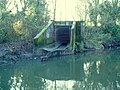 A storm drain discharging into the River Brent in the UK
 -
 Iron Cove Creek, Sydney, Australia
 -

-
 Storm drain in Obertraun, Austria
 -
 Storm drain overflowing in Durham, North Carolina
 -
 114" pipe installation; Pipe: 114" aluminized type 2; Flow: 25 cubic meters/second; This is a storm drain in Guasave, Mexico.
 -

-
 Inside the Markeaton Interceptor Storm Relief Culvert
 -
 Old storm drain in Kutná Hora, the Czech Republic


See also
[edit]References
[edit]- ^ "Highway drain". staffordshire County Council. Retrieved 5 September 2024.
- ^ a b King, James J. (1995). The environmental dictionary and regulatory cross reference (3rd ed.). New York: Wiley. ISBN 0-471-11995-4.
- ^ Amimoto, Perry Y. (1981). Erosion and Sediment Control Handbook. State of California. p. 109.
- ^ Kerb Inlet, Local Government & Municipal Knowledge Base, accessed February 6, 2010,
- ^ Field, Richard and Daniel Sullivan.Wet-Weather Flow in the Urban Watershed: Technology and Management, p. 109, at Google Books
- ^ "Fiberglass Pipe Past, Present and Future". Fiberglass Tank & Pipe. Retrieved 3 February 2022.
- ^ a b "Street Edge Alternatives (SEA Streets) Project". Seattle.gov. Archived from the original on Dec 5, 2008.
- ^ a b c "4 Expert Tips for Perfect Planter Drainage". drainservice.org. 15 April 2023. Archived from the original on June 30, 2023. Retrieved July 1, 2023.
- ^ "The Prevalence and Cost of Urban Flooding" (PDF). Center for Neighborhood Technology. May 2013. Retrieved 12 October 2021.
- ^ "Wet Weather Preparation Tips". Seattle, WA: Seattle Public Utilities. Retrieved 2024-05-13.
- ^ Nelson, Tim. "Mpls. preps for possible flooding on Christmas". Retrieved 2017-08-26.
- ^ Brattebo, B. O.; Booth, D. B. (2003). "Long-Term Stormwater Quantity and Quality Performance of Permeable Pavement Systems" (PDF). Water Research. 37 (18): 4369–4376. Bibcode:2003WatRe..37.4369B. doi:10.1016/S0043-1354(03)00410-X. PMID 14511707. Archived from the original (PDF) on 2007-03-27.
- ^ "Reinforced concrete | Definition, Properties, Advantages, & Facts". Britannica. Retrieved 2023-04-21.
- ^ Water Environment Federation, Alexandria, VA; and American Society of Civil Engineers, Reston, VA. "Urban Runoff Quality Management." WEF Manual of Practice No. 23; ASCE Manual and Report on Engineering Practice No. 87. 1998. ISBN 1-57278-039-8. Chapter 1.
- ^ Burton, G. Allen Jr.; Pitt, Robert (2001). Stormwater Effects Handbook: A Toolbox for Watershed Managers, Scientists, and Engineers. New York: CRC/Lewis Publishers. ISBN 0-87371-924-7. Archived from the original on 2009-05-19. Retrieved 2009-06-03. Chapter 2.
- ^ Shoemaker, Leslie; Lahlou, Mohammed; Doll, Amy; Cazenas, Patricia (2002). "Fact Sheet--Oil/Grit Separator Units". Stormwater Best Management Practices in an Ultra-Urban Setting: Selection and Monitoring. Washington, DC: U.S. Federal Highway Administration. Archived from the original on 2011-10-15. Retrieved 2011-11-16.
- ^ "Plastic bags clogging Bangkok's sewers complicate efforts to fight floods". The Straits Times. SPH Media Ltd. 2016-09-06.
- ^ Clinical Medicine & Research February 1, 2005 vol. 3 no. 1 3-12.
- ^ "NPS Outreach Toolbox: General Stormwater and Storm Drain Awareness". Polluted Runoff. Washington, D.C.: U.S. Environmental Protection Agency (EPA). 2017-03-22. Archived from the original on November 18, 2016.
- ^ Trout Unlimited, Calgary, AB. "How does Yellow Fish Road Work?" Archived 2009-07-17 at the Wayback Machine Accessed 2011-11-16.
- ^ Burrian, Steven J.; et al. (1999). The Historical Development of Wet-Weather Flow Management (Report). Cincinnati, OH: EPA National Risk Management Research Laboratory. EPA 600/JA-99/275.
- ^ EPA. "Combined Sewer Overflow (CSO) Control Policy." Federal Register, 59 FR 18688. April 19, 1994.
- ^ Metcalf & Eddy, Inc. (1972). Wastewater Engineering. New York: McGraw-Hill. p. 119.
- ^ "Combined Sewer Overflow Frequent Questions". National Pollutant Discharge Elimination System. EPA. 2023-06-01.
- ^ "Chicago digs deep to better manage stormwater". American City and County. London: Informa PLC. 1996-06-01.
- ^ "Combined Sewer Overflow". New York: Water Watch NYC. 2009-12-22.
- ^ United States. Water Quality Act of 1987. Pub. L. 100–4 Approved 1987-02-04. Sec. 402(p),
- ^ "Stormwater Discharges from Municipal Sources". EPA. 2024-05-08.
- ^ Woelkers, David A. (September–October 2002). "Tidal Wave: Stormwater Ordinances as a BMP for Phase II". Stormwater. Forester Media. Archived from the original on 2011-07-16.
- ^ Barboza, Tony (November 1, 2011). "Tons of L.A. River trash will be captured before it hits the sea". L.A. NOW Southern California -- this just in. Los Angeles Times. Retrieved May 18, 2021.
- ^ "Garrett, 2012, UE Magazine, Issue Three | PDF". Scribd. Retrieved 2023-03-16.
- ^ a b Adams, Guy (14 September 2009). "Subterranean home of Las Vegas's losers". The Independent. Archived from the original on 2022-05-25. Retrieved 21 May 2010.
- ^ O'Brien, Matt (2007). Beneath the Neon: Life and Death in the Tunnels of Las Vegas. Huntington Press. ISBN 978-0-929712-39-0.
- ^ Associated Press (17 April 1986). "Sewer loser". Beaver County Times. Retrieved 21 May 2010.
- ^ C. Michael Hogan (2007). "Knossos fieldnotes." Modern Antiquarian.
- ^ Arthur Coterell (1980). The Encyclopedia of Ancient Civilisations. Rainbird Publishers. pp. 176–178. ISBN 0-7112-0036-X.
- ^ "Broadside eulogy dedicated to Patrick, Earl of Marchmount, Sir Hugh Dalrymple, and others". National Library of Scotland Digital Gallery. 1705. Retrieved 5 April 2015.
External links
[edit]- EPA – Combined Sewer Overflows Archived 2014-07-14 at the Wayback Machine
- EPA Storm Drain Stenciling Took Kit
- 7 Steps to Clean Water from Great Lakes Green Initiative (example of a local public awareness program)
| International | |
|---|---|
| National | |
| Other | |
Storm drain
View on GrokipediaA storm drain, also known as a stormwater drain, is a system of conduits, typically constructed from concrete or other durable materials, that collects and transports excess rainwater and surface runoff from impervious urban surfaces such as paved streets, parking lots, and rooftops to prevent localized flooding and ensure safe passage of water away from developed areas.[1] The primary function of storm drains is to intercept stormwater at inlets like catch basins or grates and convey it through underground pipes, channels, or culverts to outlets in natural water bodies such as rivers, streams, or oceans, thereby mitigating risks of ponding and infrastructure damage during precipitation events.[2][3] Unlike sanitary sewer systems, which handle treated wastewater, storm drains generally discharge untreated runoff directly into receiving waters, raising environmental concerns due to the accumulation and conveyance of pollutants including sediments, oils, heavy metals, nutrients, and pathogens picked up from urban surfaces.[4][5] This untreated discharge contributes significantly to water quality degradation in downstream ecosystems, prompting regulatory efforts under frameworks like the U.S. Clean Water Act to implement best management practices for pollution prevention.[6][7] Effective storm drain design and maintenance are critical in densely populated regions, where impervious cover amplifies runoff volumes and velocities, potentially exacerbating erosion, habitat disruption, and flood hazards if systems are undersized or clogged.[8][9]
Definition and Nomenclature
Terminology and Regional Variations
In the United States and Canada, the terms "storm drain" and "storm sewer" are frequently used interchangeably to refer to the network of pipes, channels, and structures that collect and transport stormwater runoff from urban surfaces directly to receiving waters without treatment.[10] [11] "Storm sewer" emphasizes the piped, sewer-like conveyance, while "storm drain" often highlights entry points like grates or catch basins.[12] In the United Kingdom, equivalent systems are commonly designated as "surface water sewers" or "surface water drains," reflecting a regulatory distinction from foul sewers that handle wastewater; these terms underscore the separation of uncontaminated rainwater from sewage to prevent system overload during heavy precipitation.[13] [14] Inlets are typically called "gullies," which capture runoff from roads and pavements before channeling it into the sewer.[15] Australia and New Zealand predominantly employ "stormwater drain" or "stormwater system" for these infrastructures, with terminology often aligned in standards like those from local councils and environmental agencies; components such as diversion drains or trunk drainage highlight conveyance from roads to outlets.[16] [17] In both regions, the focus remains on managing urban runoff volumes, with "stormwater" integrating rainfall and pollutant transport considerations.[18]| Region | Primary Terms | Key Component Variations |
|---|---|---|
| US/Canada | Storm drain, storm sewer | Catch basin (inlet) |
| UK | Surface water sewer/drain | Gully (inlet) |
| Australia/NZ | Stormwater drain/system | Diversion drain (conveyance) |
Distinction from Other Drainage Systems
Storm drains, also known as stormwater sewers, are engineered systems primarily intended to collect and transport surface runoff from precipitation events, such as rain or snowmelt, away from urban areas to prevent localized flooding.[19] This runoff, which may include pollutants from streets and impervious surfaces like roads and rooftops, is typically discharged untreated directly into receiving water bodies such as rivers, streams, or coastal areas.[20] In contrast, sanitary sewers are dedicated to conveying domestic and industrial wastewater—including sewage from toilets, sinks, and showers—to centralized treatment facilities where biological, chemical, and physical processes remove contaminants before effluent release.[21] The separation of these systems, mandated in many modern urban designs since the late 19th century, reduces the risk of overwhelming treatment plants during storms and minimizes pathogen introduction into natural waterways from untreated overflows.[22] A key engineering distinction arises from combined sewer systems, which integrate stormwater and sanitary flows into a single network, a configuration prevalent in older European and North American cities built before widespread adoption of separation principles around 1900.[23] During intense rainfall, combined systems can exceed capacity, leading to combined sewer overflows (CSOs) that bypass treatment and discharge diluted sewage directly into waterways, exacerbating water quality degradation as documented in U.S. Environmental Protection Agency reports on over 700 U.S. communities affected by CSOs as of 2020.[4] Storm drains, by design, avoid such integration, prioritizing high-volume, low-frequency flow conveyance without treatment infrastructure, which allows for simpler, larger-diameter piping but necessitates separate pollution controls like street sweeping or detention basins.[24] Beyond sanitary and combined systems, storm drains differ from subsurface drainage mechanisms, such as French drains or agricultural tile systems, which target groundwater or soil saturation rather than episodic surface flows.[25] French drains, for instance, employ perforated pipes in gravel trenches to manage chronic seepage under foundations or fields, often with geotextile wraps to prevent clogging by fines, whereas storm drains feature grated inlets and smooth conduits optimized for rapid, gravity-driven transport of debris-laden runoff.[26] This functional divergence underscores storm drains' role in urban hydrology, where impervious cover amplifies peak flows—up to nine times sanitary volumes during storms—demanding scalable conveyance over filtration or slow percolation.[12]Engineering Principles and Components
Core Components: Inlets, Piping, and Outlets
Storm drain systems consist of inlets for surface water capture, underground piping for conveyance, and outlets for discharge, designed to handle peak flows from precipitation without treatment in most municipal applications.[27] Inlets intercept runoff from streets and impervious surfaces, piping transports it via gravity to avoid backups, and outlets release it into receiving waters, often with energy dissipation to prevent scour.[28] Inlets primarily include curb-opening, grate, and combination types, selected based on hydraulic efficiency and debris-handling capacity. Curb-opening inlets, positioned along gutters, capture flow through vertical or sloped openings without protruding grates, achieving interception rates up to 80% in low-flow conditions on grades exceeding 1%.[28] Grate inlets, flush with pavement or embedded in curbs, use parallel or perpendicular bars spaced 1-2 inches apart to admit water while excluding debris larger than 0.5 inches, though efficiency drops below 20% on shallow spreads due to frontal wave bypassing.[29] Combination inlets merge curb and grate features for sag locations where ponding occurs, providing redundancy; for instance, TxDOT standards specify grate areas of at least 2 square feet for continuous inlets to handle design storms.[28] Catch basins, a common inlet variant, incorporate a sump below the grate to trap sediments, with depths typically 2-4 feet to retain particles over 0.2 mm during flows up to 10 cfs.[30] Piping, often termed storm sewers when enclosed, utilizes rigid conduits sized by Manning's equation for velocities between 3-10 fps to self-clean and prevent sedimentation. Common materials include reinforced concrete pipe (RCP) for diameters 12-144 inches under high loads, corrugated metal pipe (CMP) galvanized for flexibility in 6-192 inch ranges with Manning's n=0.024, and high-density polyethylene (HDPE) for corrosion resistance in SDR 35 walls or thicker. Culverts, box or arch-shaped for spans over 12 feet, extend piping under roads; for example, single-pipe culverts up to 60 inches require flared end sections to reduce inlet losses by 20-30%.[31] Minimum slopes follow 0.5% for 24-inch pipes to achieve scouring velocities above 2.5 fps, with joints sealed to ASTM D3212 standards for watertightness in urban settings. Outlets discharge untreated stormwater into streams, rivers, or bays, engineered with headwalls, riprap aprons, or stilling basins to dissipate kinetic energy and limit tailwater effects. FAA guidelines mandate outlet invert elevations below inlet tops to maintain freeboard, with energy grades ensuring tailwater depth ratios under 0.75 for design discharges up to 100-year events.[32] Erosion control at outfalls often involves concrete chutes or rock-lined channels extending 10-20 feet downstream, as velocities exceeding 5 fps can erode unarmored banks at rates of 1-2 feet per year.[33] Multi-stage structures with orifices at varying elevations control release rates, matching pre-development peaks to mitigate downstream flooding.[34]Hydraulic Design and Capacity Sizing
Hydraulic design of storm drains determines pipe diameters, slopes, and inlet capacities to convey peak stormwater runoff under specified design storms while achieving self-cleansing velocities and limiting scour. Systems are typically sized for a 10-year return frequency event to manage frequent urban flooding, with provisions for overflow during rarer extremes like 100-year storms.[35][36] Peak discharge estimation relies on hydrologic methods, with the Rational Method predominant for areas under 200 acres: , where is peak flow in cubic feet per second, is the runoff coefficient (0 to 1, based on land surface imperviousness), is rainfall intensity in inches per hour for the basin's time of concentration, and is contributing area in acres.[37] This empirical approach assumes uniform rainfall, constant runoff fraction, and peak flow equilibrium with intensity over the time of concentration.[38] Runoff coefficients quantify surface response to rainfall, increasing with impervious cover; standard values include 0.30–0.50 for single-family residential areas, 0.60–0.75 for attached multi-unit dwellings, and 0.70–0.95 for asphalt pavement.[39]| Land Use Category | Runoff Coefficient (C) |
|---|---|
| Single-family residential | 0.30–0.50 |
| Multi-unit detached | 0.40–0.60 |
| Apartment areas | 0.50–0.70 |
| Asphalt pavement | 0.70–0.95 |
| Lawns, flat (1–2% slope) | 0.05–0.20 |
| Material | Manning's n |
|---|---|
| PVC pipe | 0.009 |
| Concrete pipe (smooth) | 0.012–0.013 |
| Corrugated metal pipe | 0.024 |
Materials and Construction Standards
Storm drain pipes are commonly constructed from reinforced concrete, thermoplastic materials such as high-density polyethylene (HDPE) and polyvinyl chloride (PVC), or corrugated metal. Reinforced concrete pipes, suitable for larger diameters and high-load applications, must conform to ASTM C76, which specifies five classes based on three-edge bearing strength requirements ranging from 1,000 to 3,000 pounds per linear foot for different wall thicknesses. HDPE pipes, featuring a smooth interior and corrugated exterior for structural rigidity, adhere to ASTM D2412 for external loading tests and ASTM D3212 for joint performance, alongside AASHTO M252 and M294 for material and corrugation specifications. PVC pipes, often used in smaller stormwater systems, comply with ASTM D1784 for compound quality and require minimum stiffness ratings to withstand soil and traffic loads. Corrugated metal pipes, typically galvanized or aluminized steel, provide flexibility in variable soils but are selected based on corrosion resistance and hydraulic efficiency per local engineering codes. Construction standards mandate precise installation to ensure structural integrity and hydraulic function. Pipes must be inspected for compliance with specifications prior to placement, including verification of material markings and defect-free joints. Trenches are excavated to provide uniform support, with bedding materials compacted to prevent settlement, and pipes laid with watertight gaskets or resilient connectors meeting ASTM C1478 for precast concrete connections to resist infiltration and exfiltration. Backfill around pipes follows graded compaction standards to distribute loads evenly, avoiding voids that could lead to pipe failure under traffic or seismic activity. Inlets and outlets incorporate grates and frames tested for load classes, such as EN 124 Class D400 for heavy-duty areas enduring up to 400 kN wheel loads. Post-installation testing, including deflection measurements for flexible pipes under ASTM D2412 protocols, verifies performance against design criteria. Local codes, such as those from the International Plumbing Code (IPC) Chapter 11, require all materials and methods to align with approved standards for durability and safety.Purposes and Empirical Benefits
Flood Control and Urban Resilience
Storm drain systems primarily mitigate urban flooding by rapidly conveying stormwater runoff from impervious surfaces—such as roads, roofs, and parking lots—away from populated areas and into receiving waters like rivers or oceans, thereby preventing localized ponding and overland flow that can inundate streets and properties.[46] Hydraulic design typically employs methods like the rational formula or continuous simulation models to size pipes and inlets for specific design storms, often targeting a 10-year return period event in many U.S. jurisdictions to limit flow depths on roadways to safe levels, with minimum pipe diameters of 15 inches (38 cm) and slopes ensuring self-cleansing velocities above 3 feet per second (0.9 m/s).[47] [48] This capacity prevents widespread surface flooding during moderate rainfall, as evidenced by modeling studies showing drainage networks reducing peak runoff volumes by 20-50% in designed catchments compared to undeveloped conditions, though effectiveness diminishes with upstream impervious expansion.[49] In terms of urban resilience, well-maintained storm drains enhance a city's ability to withstand and recover from pluvial flooding by minimizing disruptions to transportation networks and critical infrastructure; for instance, interceptor systems like those in Derby, UK, divert excess river flows into subsurface conduits during high-water events, averting combined sewer overflows and reducing downstream flood propagation.[50] Quantitative assessments indicate that upgraded stormwater piping contributes significantly to overall flood mitigation, with frameworks attributing up to 40% of risk reduction in some multi-dimensional models to piped conveyance when integrated with source controls.[51] Case studies from Japanese urban areas demonstrate that standardized storm drain expansions, combined with real-time monitoring, have lowered flood-prone area coverage by 15-30% in retrofitted basins since the 1990s, supporting economic continuity by limiting business interruptions from inundation.[52] However, empirical data from malfunction analyses reveal that clogging from debris or sediment—often exacerbated by poor maintenance—can halve system capacity, underscoring the causal link between operational upkeep and resilience outcomes.[50] Limitations in extreme events highlight the need for adaptive strategies; storm drains sized for recurrent storms frequently surcharge during rare, high-intensity downpours, leading to backups and overflows, as observed in U.S. cities where urbanization has outpaced infrastructure upgrades, resulting in increased flood vulnerabilities despite baseline protections.[46] Resilience is thus bolstered not by drains alone but through hybrid approaches, including overflow provisions and auxiliary storage, which peer-reviewed simulations show can extend effective handling to 50- or 100-year events by attenuating peaks.[53] In New York City, investments exceeding $3.8 billion in sewer enhancements from 2011 to 2021 have demonstrably curtailed chronic flooding in low-lying neighborhoods, yielding measurable reductions in emergency response costs and property damage claims during design-range storms.[54]Enabling Infrastructure for Economic Growth
Storm drain systems underpin urban economic development by enabling the expansion of impervious surfaces—such as roads, parking lots, and commercial buildings—that are essential for commerce, logistics, and industrial activity. These surfaces, while driving productivity and property values, dramatically increase stormwater runoff volumes; for instance, urban development can elevate peak runoff rates by factors of 5 to 10 times compared to pre-development conditions, necessitating robust drainage to avert inundation.[55] Without effective storm drains, such runoff would routinely cause flooding, halting transportation, damaging inventory, and deterring investment, as evidenced by estimates that each additional 10,000 cubic feet of unmanaged runoff inflicts approximately $12,000 in downstream property damages.[56] By channeling water away from developed zones, storm drains sustain year-round accessibility and operational continuity, directly supporting sectors like retail and manufacturing that contribute disproportionately to local GDP. Empirical analyses of water infrastructure, including stormwater components, reveal high economic multipliers: each $1 million invested generates up to 15 jobs through construction, maintenance, and induced economic activity.[57] The American Society of Civil Engineers identifies a $434 billion funding gap over the next decade for U.S. stormwater systems alongside related water infrastructure, underscoring how underinvestment exacerbates flood vulnerabilities that erode economic resilience and growth potential.[58] In practice, mature storm drain networks have historically facilitated suburban and exurban expansion, as seen in post-World War II U.S. cities where drainage improvements correlated with booming real estate and automotive economies by rendering low-lying lands viable for habitation and enterprise.[59] These systems thus act as enablers of capital accumulation, lowering insurance premiums and risk premiums for developers while minimizing business interruptions from wet-weather events, which can otherwise reduce regional output by billions annually in avoided losses.[60] Critically, while green infrastructure supplements traditional storm drains with infiltration benefits, the core piped networks provide the scalable capacity for high-density economic hubs, where gray infrastructure's reliability outweighs alternatives in handling extreme events. Peer-reviewed evaluations confirm that stormwater management investments, inclusive of storm drains, yield positive net returns by safeguarding assets valued in trillions across urban portfolios.[61] Neglect, conversely, amplifies costs through deferred maintenance and flood recovery, as commercial sites with clogged or undersized drains face revenue losses from closures and heightened liability.[62] This infrastructure's role in causal chains—from site permitting to sustained trade flows—positions it as indispensable for long-term prosperity in rainfall-prone regions.Property and Public Safety Protections
Storm drainage systems protect private and public property by rapidly conveying excess surface runoff away from urban and suburban landscapes, thereby averting inundation that could lead to structural compromise, foundation erosion, and material degradation in buildings and infrastructure.[63] In engineered designs, inlets and piping networks channel water into larger conduits or retention areas, preventing localized ponding that exacerbates hydrostatic pressure on walls and basements; for instance, routine maintenance of these systems has been documented to sustain property integrity during intense precipitation events by limiting water exposure durations to under critical thresholds.[64] Empirical assessments indicate that conveyance-focused drainage, when integrated with storage elements, can mitigate up to 92% of potential flood-induced economic losses to real estate and utilities by redistributing hydraulic loads spatially and temporally.[65] Public safety enhancements derive from diminished flood velocities and depths on roadways and pedestrian zones, curtailing hydroplaning incidents, visibility impairments, and swift-water rescue necessities that claim numerous lives annually in unmanaged runoff scenarios.[58] Targeted infrastructure upgrades, such as those in flood-vulnerable municipalities, have empirically shortened street submersion periods—reducing exposure to hazardous currents—from hours to minutes during storms exceeding design capacities, thereby preserving access for emergency services and averting secondary perils like electrocution from compromised power lines.[66] Comprehensive stormwater protocols further safeguard against vector proliferation and contaminant mobilization in stagnant pools, which otherwise amplify disease transmission risks; U.S. Environmental Protection Agency analyses underscore that proactive drainage averts these cascading threats, correlating with lower incidence of waterborne illnesses in serviced areas post-deluge.[67]Historical Development
Ancient Origins and Early Engineering
The earliest known urban drainage systems, including elements for stormwater management, emerged in ancient Mesopotamia around 4000–2500 BCE, where street drains facilitated runoff from rainfall in early cities like Uruk.[68] These rudimentary channels, often open and lined with basic materials, addressed flooding in densely settled areas prone to seasonal inundation from the Tigris and Euphrates rivers, marking an initial engineering response to urban water accumulation.[68] By the mid-3rd millennium BCE, the Indus Valley Civilization developed more sophisticated integrated drainage networks in cities such as Mohenjo-Daro and Lothal, dating to approximately 2600–1900 BCE.[69] At Lothal, a port city constructed around 2300 BCE, brick-lined sewers up to 1.5 meters deep and 91 centimeters wide connected households and streets, channeling both wastewater and stormwater to larger outlets, with covered channels preventing overflow and maintaining flow efficiency.[70] This system, built with precisely joined bricks, demonstrated advanced hydraulic foresight, as excavations reveal uniform gradients ensuring consistent drainage even during monsoonal rains.[70] In parallel, Minoan Crete (ca. 3200–1100 BCE) employed terracotta pipes to convey stormwater from settlements, integrating sloped conduits into urban layouts to divert runoff from roofs and streets toward coastal discharges.[71] These pipes, often socketed for assembly, prioritized separation of flows where possible, reducing sedimentation and enabling reuse of cleaner water sources, as evidenced by palace complexes like Knossos with multi-level drainage tiers.[71] Ancient Chinese engineering yielded the oldest known ceramic pipe drainage system around 2200 BCE in the Liangzhu culture near modern Hangzhou, featuring interconnected U-shaped tiles forming grids up to several kilometers long to manage heavy seasonal floods.[72] This network, preserved in archaeological contexts, supported permanent settlements by mitigating waterlogging in low-lying areas, with pipes sized to handle peak flows from Yangtze tributaries.[72] Roman innovations peaked with the Cloaca Maxima, initiated as an open canal around 600 BCE under Etruscan influence and later vaulted with stone by 500 BCE, spanning 1.3 kilometers to drain the Forum Romanum and adjacent valleys into the Tiber River.[73] Engineered with a consistent 0.5% gradient using opus caementicium concrete and voussoir arches for structural integrity, it capacitated flows exceeding 15 cubic meters per second during storms, exemplifying scalable hydraulic design that influenced subsequent Mediterranean infrastructure.[73][74]18th-19th Century Urban Expansions
The Industrial Revolution spurred unprecedented urban growth in Europe and North America, with cities like London expanding from approximately 1 million residents in 1801 to over 2.3 million by 1851, necessitating stormwater management to handle increased runoff from impervious surfaces such as paved roads and rooftops. Prior to widespread enclosure, urban drainage relied on open gutters and ditches, which proved inadequate amid denser construction and frequent flooding; this prompted transitions to brick-arched and later piped systems to convey stormwater efficiently beneath expanding street grids, reducing inundation risks that threatened infrastructure and commerce.[75][76] In London, mid-19th-century reforms addressed chronic overflows exacerbated by population surges, culminating in Joseph Bazalgette's Main Drainage system (constructed 1859–1875), featuring 132 km of intercepting sewers with diameters up to 2.7 meters designed to capture and divert both sewage and peak stormwater flows to the Thames Estuary via gravity, thereby alleviating inner-city flooding during heavy precipitation. Bazalgette's engineering incorporated oversized conduits—anticipating future urban demands—and pumping stations like Crossness (opened 1865), which handled combined flows exceeding 100,000 cubic feet per minute, enabling sustained expansion without recurrent waterlogging.[77][78][75] Paris underwent parallel transformations under Napoleon III's modernization (1853–1870), where engineer Eugène Belgrand constructed over 570 km of sewers by 1878, including egg-shaped conduits optimized for self-cleansing at low flows and high-velocity stormwater discharge, integrated beneath Haussmann's broad boulevards to drain newly developed districts and prevent backups in the Seine watershed. This network, fed by gravity from peripheral reservoirs, managed runoff from expanded impervious areas—covering an additional 20 square kilometers of urban fabric—while mandating household connections under the "tout à l'égout" policy, which minimized surface ponding and supported population growth to 2 million by 1900.[79][80] Across the Atlantic, New York City laid approximately 70 miles of sewers between 1849 and 1855, expanding to over 300 miles by century's end, with early brick and stone storm drains channeling rainwater from Manhattan's grid to outfalls in the Hudson and East Rivers, accommodating the borough's growth from 200,000 residents in 1830 to 1.9 million by 1900 amid intensified paving and tenement construction. These systems, often combined with rudimentary sanitary lines, mitigated flood-prone lowlands like the Collect Pond basin, though limitations in capacity led to overflows until later vitrified clay pipe adoptions in the 1870s improved durability and flow efficiency.[81][82]20th Century Standardization and Modeling
In the early 20th century, storm drainage systems in the United States and Europe increasingly standardized separate infrastructure from sanitary sewers, a shift prompted by public health concerns over combined overflows during heavy rains. This separation, advocated in engineering reports following urban floods like the 1913 Ohio inundation, reduced contamination risks and became codified in municipal ordinances by the 1920s. Materials such as vitrified clay pipes, standardized for corrosion resistance, and early reinforced concrete pipes, introduced around 1910 for larger diameters, gained prevalence through specifications from bodies like the American Society for Testing and Materials (ASTM), ensuring uniform strength ratings (e.g., D-loads for burial depths) and joint types for watertight assembly.[83][84] Hydraulic design standardized around empirical formulas refined from the 19th century. The Rational Method, Q = C i A (where Q is peak discharge in cfs, C the runoff coefficient varying 0.1-0.9 by surface, i rainfall intensity in in/hr for duration equal to time of concentration, and A area in acres), was routinely applied for catchments under 200 acres, with design storms often 10- to 25-year events yielding intensities of 2-5 in/hr in temperate climates. Pipe sizing used Manning's equation, V = (1.49/n) R^{2/3} S^{1/2} (in US customary units, n roughness 0.013-0.024 for concrete), targeting full-flow velocities of 3-10 ft/s to balance scour and sedimentation. These methods, detailed in textbooks and local codes, enabled manual computations for branched networks, prioritizing rapid conveyance over storage.[85][86] Mid-century publications further unified practices. The ASCE/WPCF Manual of Engineering Practice No. 37, "Design and Construction of Sanitary and Storm Sewers" (1969 edition), outlined procedures for inlet spacing, pipe gradients (minimum 0.4-0.5% for self-cleansing), and hydraulic grade lines to prevent surcharging, influencing standards adopted by over 100 U.S. municipalities. By the 1960s, on-site detention basins emerged in suburban designs to attenuate peaks, responding to post-WWII sprawl and events like the 1965 Northeast blackout floods.[87][88] Late-20th-century modeling advanced with computation. The EPA's Storm Water Management Model (SWMM), developed 1969-1971 and coded in Fortran, simulated continuous hydrology via unit hydrographs and kinematic wave routing, handling complex interactions like ponding and overflows—capabilities beyond static Rational applications. Adopted by agencies for systems exceeding 100 acres, SWMM incorporated parameters like infiltration (e.g., Horton's equation) and pollutants, supporting regulatory compliance under the 1972 Clean Water Act, though early versions required mainframes until PC ports in the 1980s. This evolution shifted designs from purely conveyance-focused to capacity-verified via iterative simulations, reducing empirical guesswork.[89]Post-2000 Innovations and Adaptations
In the early 2000s, stormwater management evolved from predominantly engineered piped systems toward integrated low-impact development (LID) and sustainable urban drainage systems (SuDS), prioritizing source control through infiltration, evaporation, and bio-filtration to mitigate urban runoff volumes and peaks. These approaches, building on 1990s concepts, addressed empirical evidence of increased flooding from impervious surfaces, with LID techniques like bioretention cells and permeable pavements demonstrated to retain up to 90% of stormwater from small events in controlled studies.[90] The 2000 Maryland Stormwater Design Manual codified environmental site design principles, mandating practices such as minimizing impervious cover and using vegetated filters for new developments, which reduced downstream erosion and pollutant loads compared to conventional detention basins.[91] In Europe, SuDS adoption accelerated post-2000, with Scotland implementing mandatory requirements for sustainable drainage in urban planning from 2001, following pilot projects like the 2000 Dunfermline demonstration that integrated swales and ponds to achieve 50-70% flow attenuation in field tests.[92] These systems emphasized multi-functional landscapes, empirically lowering combined sewer overflows by 30-50% in retrofitted catchments through extended detention and natural treatment trains.[93] By mid-decade, U.S. EPA Phase II stormwater regulations incentivized LID nationwide, with case studies showing 20-50% cost savings over traditional infrastructure by decentralizing control and leveraging site-specific hydrology.[90] Technological adaptations included early 2000s advancements in distributed sensor networks for real-time hydraulic monitoring, enabling data-driven operations like automated gate controls to prevent surcharging during storms exceeding design capacities of 10-25 year events.[94] This shift supported adaptive sizing, with post-2010 integrations of IoT devices logging flow velocities and pollutant levels at sub-hourly intervals, informing maintenance that extended asset life by 15-20% in monitored urban networks. Overall, these innovations responded to observed 10-20% increases in extreme precipitation since 2000, enhancing system capacities without proportional pipe expansions.[95]Modern Practices and Technologies
Traditional Construction Techniques
Traditional storm drain construction employs open-cut trenching to install rigid pipes such as reinforced concrete pipe (RCP) compliant with AASHTO M 170 standards, which provide structural strength for gravity flow conveyance under urban loads. These methods prioritize soil-tight or watertight joints using rubber gaskets or mortar to minimize infiltration while ensuring alignment for hydraulic efficiency.[96] Excavation begins with trenching to a depth ensuring minimum cover—typically 1 foot in non-load areas and 2 feet under roadways—with trench widths of pipe diameter plus 24 inches for pipes ≤36 inches or plus 48 inches for larger diameters to accommodate bedding and compaction equipment.[96] Bedding preparation follows, involving compaction of the trench bottom and placement of select aggregate (e.g., AASHTO No. 57 or M 145 A-1/A-3 soils) shaped to support the pipe invert and bell for RCP, providing uniform foundation to distribute loads and prevent deflection.[96] Pipes are laid starting from the outlet end, mechanically handled for RCP to maintain elevations and slopes (often 0.5-1% minimum), with joints assembled using elastomeric seals or mortar for RCP to achieve soil-tight integrity.[96] [97] Backfilling occurs in 6-inch lifts of granular material or approved soil, compacted to at least 95% standard Proctor density using methods like Kentucky Method 64-511, extending 1 foot above the pipe crown to stabilize the installation against settlement and future loads.[96] Associated structures, such as precast concrete manholes and catch basins with grated inlets, are constructed concurrently or sequentially, connected via short pipe runs and sealed to integrate with the mainline.[98] These techniques, while disruptive to surface activities, remain standard for their reliability in verifiable load-bearing and longevity, with RCP demonstrating service lives exceeding 100 years under proper installation.Alternative and Sustainable Methods
Alternative and sustainable methods for stormwater management prioritize decentralized approaches that mimic natural hydrological processes, such as infiltration and evapotranspiration, over conventional piped conveyance systems. These techniques, often grouped under low-impact development (LID) or green infrastructure (GI), aim to retain, infiltrate, or treat runoff near its source to reduce downstream flooding, recharge groundwater, and filter pollutants.[99][100] LID practices have been implemented since the 1990s in regions like the Pacific Northwest and Maryland, with adoption accelerating post-2000 due to regulatory pressures on water quality under frameworks like the U.S. Clean Water Act.[101] Permeable pavements, including porous asphalt and pervious concrete, allow stormwater to infiltrate through voids in the surface into underlying aggregate reservoirs, reducing runoff volumes by up to 70-90% for small storms in field studies.[102][103] These systems also attenuate peak flows and remove contaminants like heavy metals and oils via sedimentation and biological filtration, with peer-reviewed evaluations showing pollutant reductions of 50-80% in total suspended solids and hydrocarbons.[104] However, long-term performance depends on maintenance to prevent clogging from sediments, which can reduce infiltration rates by 20-50% over 5-10 years without regular vacuum sweeping.[105] Suitability is limited in areas with high sediment loads or fine soils prone to sealing, where infiltration capacities may drop below 100 mm/hour thresholds needed for effective function.[106] Vegetated systems such as bioswales and rain gardens (bioretention cells) channel and detain runoff in engineered depressions filled with amended soil and plants, promoting infiltration and pollutant uptake. Bioswales can reduce stormwater volumes by 30-50% through evapotranspiration and infiltration while filtering 95-98% of metals like cadmium, zinc, and lead from highway runoff.[107][108] Rain gardens similarly detain water for 24-72 hours, achieving 40-60% volume reduction in urban settings, with native plants enhancing biodiversity and soil microbial degradation of organics.[109] Effectiveness data from USGS-monitored sites indicate these practices lower peak discharges by factors of 2-5 compared to impervious surfaces, though overflow risks persist during extreme events exceeding design storms (e.g., 25-mm/hour intensities).[110] Maintenance challenges include plant die-off from prolonged saturation and sediment accumulation, necessitating annual inspections and replanting.[111] Green roofs and underground detention systems complement surface methods in space-constrained urban areas. Extensive green roofs retain 50-75% of annual rainfall via vegetation layers, reducing roof runoff and insulating buildings, with lifecycle analyses showing energy savings offsetting initial costs over 20-40 years.[112] Modular underground tanks or arch chambers store excess water for slow release, achieving 80-90% peak flow reduction without surface disruption, though higher upfront costs (20-50% more than pipes) require long-term benefits like flood avoidance to justify.[113] Comparative cost-benefit studies report LID/GI yielding 23% lower lifecycle costs than traditional storage over 50 years in retrofits, driven by avoided pipe expansions and treatment, but upfront investments can exceed conventional methods by 10-30% in initial capital.[114][115] Empirical evidence underscores context-dependency: successes in permeable climates like Seattle contrast with limitations in arid zones where evaporation dominates over infiltration, highlighting the need for site-specific hydrologic modeling.[116]Smart Systems and Recent Advancements (2020s)
In the 2020s, smart storm drain systems have advanced through the integration of Internet of Things (IoT) sensors and artificial intelligence (AI), enabling real-time data collection and predictive modeling to mitigate urban flooding and optimize drainage performance.[117] These technologies address limitations in traditional systems by providing continuous monitoring of water levels, flow rates, and pollutant loads, with deployments showing up to 30% improvements in flood response times in pilot urban areas.[118] IoT networks, often comprising ultrasonic or pressure sensors embedded in drain inlets and pipes, transmit data via wireless protocols to central platforms for immediate analysis, reducing overflow risks during extreme rainfall events.[119] Key developments include IoT-based blockage detection systems, which use flow and level sensors to identify obstructions in real time, as validated in a 2024 field study where sensors achieved 95% accuracy in alerting maintenance teams before capacity failures.[119] The U.S. Environmental Protection Agency (EPA) has prototyped remote sensors for stormwater outfalls, measuring stream depth and velocity to inform erosion control and habitat protection, with initial deployments in 2025 demonstrating reliable data relay over cellular networks.[120] Ultra-high frequency radio-frequency identification (UHF-RFID) tags combined with sensors have emerged for non-invasive monitoring of sewer and storm drain levels, detecting anomalies like sediment buildup with sub-hourly resolution in laboratory tests conducted in 2025.[121] AI and machine learning enhancements focus on predictive flood forecasting by processing sensor data alongside meteorological inputs, outperforming physics-based models in urban settings with rapid urbanization.[122] For example, the Intelligent Flood Control Decision Support System (IFCDSS), implemented in select cities by 2025, employs neural networks to simulate drainage network responses, automating gate operations and issuing warnings 1-2 hours ahead of peak flows with 85-90% precision in validation datasets.[123] Machine learning algorithms integrated into urban hydrological models have reduced prediction errors for inundation extents by incorporating real-time drain telemetry, as shown in 2024 analyses of aging infrastructure in mid-sized watersheds.[124] These systems collectively enhance causal understanding of drainage dynamics under variable climate conditions, though scalability challenges persist due to sensor durability in corrosive environments and data privacy in interconnected networks.[125] Deployment costs have decreased by approximately 20% since 2020 through modular IoT hardware, facilitating adoption in over 50 municipal pilots worldwide by mid-decade.[126]Environmental and Ecological Interactions
Effects on Water Quantity and Flow Dynamics
Storm drains facilitate the rapid collection and conveyance of surface runoff from urban impervious surfaces, such as roads and rooftops, to nearby water bodies, fundamentally altering natural hydrologic processes that involve infiltration, detention, and evapotranspiration.[127] This engineered routing reduces travel time for stormwater, resulting in hydrographs with steeper rising limbs and higher peak flows during precipitation events compared to pre-development conditions dominated by pervious landscapes.[128] Empirical studies in urbanizing watersheds document peak discharge increases of up to several times the natural rate, driven by the concentration of flow through piped networks that bypass soil absorption.[49] The quantity of water reaching streams via storm drains exceeds natural runoff volumes because impervious cover limits infiltration losses, with typical urban areas generating 2-5 times more direct runoff per unit rainfall than rural counterparts.[128] Conversely, baseflows—sustained streamflows from groundwater discharge—decline significantly, with observations of up to 30% reductions attributed to diminished recharge from piped diversions that prevent water from percolating into aquifers.[128] This shift produces "flashier" flow regimes, characterized by rapid onset and recession of high flows interspersed with protracted low flows, exacerbating channel erosion and sediment transport downstream.[127] Hydraulic modeling and field data confirm that storm drain outlets deliver flows with velocities often exceeding 1-2 m/s, promoting scour in receiving channels absent natural buffering.[129] In heavily drained urban systems, these dynamics contribute to altered streamflow timing, with stormwater pulses arriving synchronously from multiple catchments, amplifying flood risks during intense storms.[130] Quantitatively, watersheds with extensive storm drain networks exhibit annual runoff coefficients of 0.4-0.8, versus 0.1-0.3 in undeveloped areas, underscoring the infrastructure's role in elevating total water export while depleting subsurface storage.[128] Such changes persist across scales, from small headwater streams showing order-of-magnitude flow variability to larger rivers experiencing synchronized peaks from tributary confluences.[131]Pollutant Transport and Quality Data
Storm drains facilitate the rapid conveyance of stormwater runoff, which entrains pollutants from impervious urban surfaces such as roads, parking lots, and rooftops, delivering them untreated to receiving water bodies. Pollutants are mobilized through mechanisms including surface erosion, atmospheric deposition, and leaching from materials like vehicle tires, brake pads, and building facades; particulate-bound contaminants settle during dry periods and are resuspended during wet weather flows, while soluble fractions dissolve directly into runoff. This transport is exacerbated by high flow velocities in storm drain networks, which minimize sedimentation within pipes and promote scour of accumulated deposits, resulting in pulsed pollutant loads during storms rather than steady-state discharge.[132][133] Common pollutants include suspended solids, heavy metals, nutrients, and pathogens. Heavy metals such as copper, lead, and zinc predominate, originating primarily from vehicular sources; for instance, copper from brake wear and zinc from tire abrasion. Nutrients like total nitrogen (TN) and total phosphorus (TP) derive from fertilizers, animal wastes, and atmospheric inputs, contributing to downstream eutrophication. Pathogens, including fecal coliforms and enterococci, enter via wildlife feces, pet waste, or illicit sanitary cross-connections, with concentrations often exceeding recreational water quality standards during and immediately after storms. Organic compounds such as polycyclic aromatic hydrocarbons (PAHs) and emerging contaminants like pharmaceuticals also occur, though at trace levels.[132][134][132] Quality data are typically expressed as event mean concentrations (EMCs), averaging pollutant levels over a storm event to account for temporal variability. Urban stormwater EMCs vary by land use, antecedent dry days, and rainfall intensity, but national profiles indicate median values for residential/commercial areas of approximately 50-150 mg/L total suspended solids (TSS), 0.2-0.5 mg/L TP, 1.5-3 mg/L TN, 10-30 μg/L copper, 5-20 μg/L lead (declining post-unleaded fuel era), and 100-300 μg/L zinc. Pathogen EMCs for fecal coliforms frequently range from 10^4 to 10^6 MPN/100 mL, with higher loads in watersheds with dense animal populations or failing septic systems. Pollutant loads exhibit high variability—up to orders of magnitude between events—driven by the "first flush" effect, where initial runoff volumes carry disproportionately high concentrations due to accumulated dry-weather buildup. Industrial sites show elevated metals (e.g., chromium up to 50 μg/L), while agricultural-adjacent areas yield higher nutrients.[132][135][132]| Pollutant | Typical Urban EMC Range | Primary Sources | Notes on Variability |
|---|---|---|---|
| TSS (mg/L) | 50-150 | Erosion, litter | Higher in construction phases; first flush amplifies loads by 20-50%.[132] |
| TP (mg/L) | 0.2-0.5 | Fertilizers, detergents | Peaks with lawn/park runoff; particle-bound fraction ~70%.[132] |
| Copper (μg/L) | 10-30 | Brakes, corrosion | Declined 50-80% since 1990s due to regulations.[134] |
| Lead (μg/L) | 5-20 | Historical fuel, paint | Urban legacy; soluble fraction low (<10%).[134] |
| Fecal Coliforms (MPN/100 mL) | 10^4-10^6 | Fecal matter, sewage | Exceeds EPA criteria in >80% of events; dies off rapidly post-discharge.[132][136] |