Recent from talks
Tehran
Knowledge base stats:
Talk channels stats:
Members stats:
Tehran
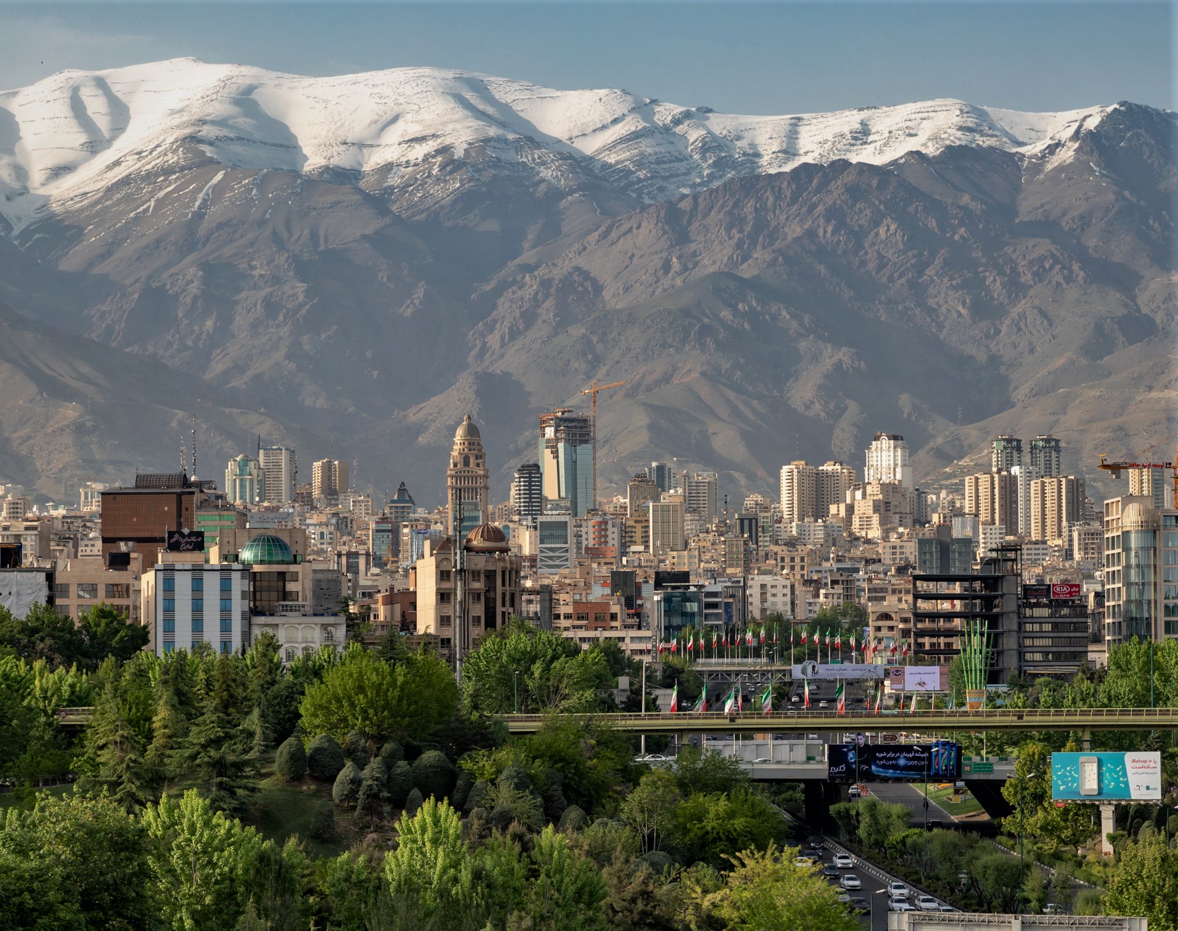
Tehran is the capital and largest city of Iran. It is also the capital of Tehran province and the administrative center for Tehran County and its Central District. With a population of around 9.8 million in the city, and 16.8 million in the metropolitan area, Tehran is the most populous city in Iran and Western Asia, the second-largest metropolitan area in the Middle East after Cairo, and the 24th-most-populous metropolitan area in the world. Greater Tehran includes several municipalities, including Karaj, Eslamshahr, Shahriar, Qods, Malard, Golestan, Pakdasht, Qarchak, Nasimshahr, Parand, Pardis, Andisheh and Fardis.
In classical antiquity, part of the territory of present-day Tehran was occupied by Rhages (now Ray), a prominent Median city that was destroyed in the medieval Arab, Turkic, and Mongol invasions. Modern Ray was absorbed into the metropolitan area of Greater Tehran. Tehran was first chosen as the capital of Iran in 1786 by Agha Mohammad Khan of the Qajar dynasty, due to its proximity to Iran's territories in the Caucasus—which were contested in the Russo-Iranian Wars—and to avoid the vying factions of prior ruling Iranian dynasties; the capital of Iran had been moved several times throughout its long history, with Tehran becoming the 32nd. Under Naser al-Din Shah (1848-1896), Tehran witnessed Iran's first institute of higher learning, bank, railway line, and museum. Large-scale construction works began in the 1920s, and Tehran became a destination for mass migrations from all over Iran in the 20th century.
Tehran is home to many historical sites, including the World Heritage Site Golestan Palace of the Qajar dynasty and the Masoudieh,Sa'dabad, Niavaran and Marmar palace complexes of both the Qajar and Pahlavi dynasties. Landmarks include the Azadi Tower, a memorial built in 1971 to mark the 2,500th anniversary of the Persian Empire; the Milad Tower, the world's sixth-tallest self-supporting tower, completed in 2007; and the Tabiat Bridge, completed in 2014.
Most residents of Tehran are Persian, of whom roughly 99% speak the Persian language; there are numerous other ethnolinguistic groups that are Persianised and assimilated. Tehran has been described as a cultural "melting pot", hosting more Azerbaijanis than any other city in the world. Tehran is served by Imam Khomeini International Airport, alongside the domestic Mehrabad Airport, a central railway station, Tehran Metro, the Tehran Bus Rapid Transit system, trolleybuses, and a large network of highways.
Due to air pollution and earthquakes, there have been plans to relocate the capital to another area, although none have been approved. A 2016 survey of 230 cities across the globe by Mercer ranked Tehran 203rd for quality of life. According to the Global Destinations Cities Index in 2016, Tehran is among the top ten fastest growing tourism destinations. In 2016, the Tehran City Council declared 6 October "Tehran Day", celebrating the date in 1907 when the city officially became the capital of Iran.
Various theories on the origin of the name Tehran have been put forward. Iranian linguist Ahmad Kasravi, in an article "Shemiran-Tehran", suggests that Tehran and Kehran mean "the warm place", and "Shemiran" means "the cool place". He lists cities with the same base and suffix and studied the components of the word in ancient Iranian languages, and came to the conclusion that Tehran and Kehran meant the same thing in different Iranian language families, as the constant "t" and "k" are close to each other in such languages. He also provided evidence that cities named "Shemiran" were colder than those named "Tehran" or "Kehran". He considered other theories not consider the ancient history of Iranian languages, such as "Tirgan" theory and "Tahran" theory folk etymology.
The official City of Tehran website says that "Tehran" comes from the Persian words "Tah" meaning "end", or "bottom", and "Ran" meaning "[mountain] slope"—, the bottom of the mountain (ته کوه), referring to Tehran's position at the foot of the Alborz mountains.
The most interesting toponymic theory of the place name Tehran is proposed by the Iranian linguist Zana Vahidzadeh (Dana Pishdar). According to Dana Pishdar, the etymological root of the place name Tehran should be sought in the ancient Iranian languages, such as Median and Avestan. Since the city of Rey and the area around Tehran were the largest cities in the Media region in pre-Islamic times, and since in Zoroastrian times they were considered a holy city and the center of a theocratic government similar to modern Vatican City, this suggestion does not sound illogical.
Hub AI
Tehran AI simulator
(@Tehran_simulator)
Tehran
Tehran is the capital and largest city of Iran. It is also the capital of Tehran province and the administrative center for Tehran County and its Central District. With a population of around 9.8 million in the city, and 16.8 million in the metropolitan area, Tehran is the most populous city in Iran and Western Asia, the second-largest metropolitan area in the Middle East after Cairo, and the 24th-most-populous metropolitan area in the world. Greater Tehran includes several municipalities, including Karaj, Eslamshahr, Shahriar, Qods, Malard, Golestan, Pakdasht, Qarchak, Nasimshahr, Parand, Pardis, Andisheh and Fardis.
In classical antiquity, part of the territory of present-day Tehran was occupied by Rhages (now Ray), a prominent Median city that was destroyed in the medieval Arab, Turkic, and Mongol invasions. Modern Ray was absorbed into the metropolitan area of Greater Tehran. Tehran was first chosen as the capital of Iran in 1786 by Agha Mohammad Khan of the Qajar dynasty, due to its proximity to Iran's territories in the Caucasus—which were contested in the Russo-Iranian Wars—and to avoid the vying factions of prior ruling Iranian dynasties; the capital of Iran had been moved several times throughout its long history, with Tehran becoming the 32nd. Under Naser al-Din Shah (1848-1896), Tehran witnessed Iran's first institute of higher learning, bank, railway line, and museum. Large-scale construction works began in the 1920s, and Tehran became a destination for mass migrations from all over Iran in the 20th century.
Tehran is home to many historical sites, including the World Heritage Site Golestan Palace of the Qajar dynasty and the Masoudieh,Sa'dabad, Niavaran and Marmar palace complexes of both the Qajar and Pahlavi dynasties. Landmarks include the Azadi Tower, a memorial built in 1971 to mark the 2,500th anniversary of the Persian Empire; the Milad Tower, the world's sixth-tallest self-supporting tower, completed in 2007; and the Tabiat Bridge, completed in 2014.
Most residents of Tehran are Persian, of whom roughly 99% speak the Persian language; there are numerous other ethnolinguistic groups that are Persianised and assimilated. Tehran has been described as a cultural "melting pot", hosting more Azerbaijanis than any other city in the world. Tehran is served by Imam Khomeini International Airport, alongside the domestic Mehrabad Airport, a central railway station, Tehran Metro, the Tehran Bus Rapid Transit system, trolleybuses, and a large network of highways.
Due to air pollution and earthquakes, there have been plans to relocate the capital to another area, although none have been approved. A 2016 survey of 230 cities across the globe by Mercer ranked Tehran 203rd for quality of life. According to the Global Destinations Cities Index in 2016, Tehran is among the top ten fastest growing tourism destinations. In 2016, the Tehran City Council declared 6 October "Tehran Day", celebrating the date in 1907 when the city officially became the capital of Iran.
Various theories on the origin of the name Tehran have been put forward. Iranian linguist Ahmad Kasravi, in an article "Shemiran-Tehran", suggests that Tehran and Kehran mean "the warm place", and "Shemiran" means "the cool place". He lists cities with the same base and suffix and studied the components of the word in ancient Iranian languages, and came to the conclusion that Tehran and Kehran meant the same thing in different Iranian language families, as the constant "t" and "k" are close to each other in such languages. He also provided evidence that cities named "Shemiran" were colder than those named "Tehran" or "Kehran". He considered other theories not consider the ancient history of Iranian languages, such as "Tirgan" theory and "Tahran" theory folk etymology.
The official City of Tehran website says that "Tehran" comes from the Persian words "Tah" meaning "end", or "bottom", and "Ran" meaning "[mountain] slope"—, the bottom of the mountain (ته کوه), referring to Tehran's position at the foot of the Alborz mountains.
The most interesting toponymic theory of the place name Tehran is proposed by the Iranian linguist Zana Vahidzadeh (Dana Pishdar). According to Dana Pishdar, the etymological root of the place name Tehran should be sought in the ancient Iranian languages, such as Median and Avestan. Since the city of Rey and the area around Tehran were the largest cities in the Media region in pre-Islamic times, and since in Zoroastrian times they were considered a holy city and the center of a theocratic government similar to modern Vatican City, this suggestion does not sound illogical.
Recent media