.jpg/250px-Amazon17_(5641020319).jpg "Amazon rainforest")
.jpg/2000px-Amazon17_(5641020319).jpg)
Community hub
Recent from talks
Contribute something
Nothing was collected or created yet.
Amazon rainforest
View on Wikipedia
Key Information
.jpg)
.svg)
| Part of a series on the |
| Amazon rainforest |
|---|
 |
The Amazon rainforest,[a] also called the Amazon jungle or Amazonia, is a moist broadleaf tropical rainforest in the Amazon biome that covers most of the Amazon basin of South America. This basin encompasses 7 million km2 (2.7 million sq mi),[2] of which 6 million km2 (2.3 million sq mi) are covered by the rainforest.[3] This region includes territory belonging to nine nations and 3,344 indigenous territories.
The majority of the forest, 60%, is in Brazil, followed by Peru with 13%, Colombia with 10%, and with minor amounts in Bolivia, Ecuador, French Guiana, Guyana, Suriname, and Venezuela. Four nations have "Amazonas" as the name of one of their first-level administrative regions, and France uses the name "Guiana Amazonian Park" for French Guiana's protected rainforest area. The Amazon represents over half of the total area of remaining rainforests on Earth,[4] and comprises the largest and most biodiverse tract of tropical rainforest in the world, with an estimated 390 billion individual trees in about 16,000 species.[5]
More than 30 million people of 350 different ethnic groups live in the Amazon, which are subdivided into 9 different national political systems and 3,344 formally acknowledged indigenous territories. Indigenous peoples make up 9% of the total population, and 60 of the groups remain largely isolated.[6]
Large scale deforestation is occurring in the forest, creating different harmful effects. Economic losses due to deforestation in Brazil could be approximately 7 times higher in comparison to the cost of all commodities produced through deforestation. In 2023, the World Bank published a report proposing a non-deforestation based economic program in the region.[7][8] Deforestation hurts agriculture so severely that it can lead to "agro-suicide."[9]
Etymology
[edit]The name Amazon is said to arise from a war Francisco de Orellana fought with the Tapuyas and other tribes. The women of the tribe fought alongside the men, as was their custom.[10] Orellana derived the name Amazonas from the Amazons of Greek mythology, described by Herodotus and Diodorus.[10]
History
[edit]


Based on archaeological evidence from an excavation at Caverna da Pedra Pintada, human inhabitants first settled in the Amazon region at least 11,200 years ago.[12] Subsequent development led to late-prehistoric settlements along the periphery of the forest by AD 1250, which induced alterations in the forest cover.[13]
For a long time, it was thought that the Amazon rainforest was never more than sparsely populated, as it was impossible to sustain a large population through agriculture given the poor soil. Archeologist Betty Meggers was a prominent proponent of this idea, as described in her book Amazonia: Man and Culture in a Counterfeit Paradise. She claimed that a population density of 0.2 inhabitants per square kilometre (0.52/sq mi) is the maximum that can be sustained in the rainforest through hunting, with agriculture needed to host a larger population.[14] However, recent anthropological findings have suggested that the region was actually densely populated.[15] The Upano Valley sites in present-day eastern Ecuador predate all known complex Amazonian societies.[16]
Some 5 million people may have lived in the Amazon region in AD 1500, divided between dense coastal settlements, such as that at Marajó, and inland dwellers.[17] Based on projections of food production, one estimate suggests over 8 million people living in the Amazon in 1492.[18] By 1900, the native indigenous population had fallen to 1 million and by the early 1980s it was less than 200,000.[17]
The first European to travel the length of the Amazon River was Francisco de Orellana in 1542.[19] The BBC's Unnatural Histories presents evidence that Orellana, rather than exaggerating his claims as previously thought, was correct in his observations that a complex civilization was flourishing along the Amazon in the 1540s. The Pre-Columbian agriculture in the Amazon Basin was sufficiently advanced to support prosperous and populous societies. It is believed that civilization was later devastated by the spread of diseases from Europe, such as smallpox.[20] This civilization was investigated by the British explorer Percy Fawcett in the early twentieth century. The results of his expeditions were inconclusive, and he disappeared mysteriously on his last trip. His name for this lost civilization was the City of Z.[citation needed]
Since the 1970s, numerous geoglyphs have been discovered on deforested land dating between AD 1–1250, furthering claims about Pre-Columbian civilizations.[21][22] Ondemar Dias is accredited with first discovering the geoglyphs in 1977, and Alceu Ranzi is credited with furthering their discovery after flying over Acre.[20][23] The BBC's Unnatural Histories presented evidence that the Amazon rainforest, rather than being a pristine wilderness, has been shaped by man for at least 11,000 years through practices such as forest gardening and terra preta.[20] Terra preta is found over large areas in the Amazon forest; and is now widely accepted as a product of indigenous soil management. The development of this fertile soil allowed agriculture and silviculture in the previously hostile environment; meaning that large portions of the Amazon rainforest are probably the result of centuries of human management, rather than naturally occurring as has previously been supposed.[24] In the region of the Xingu tribe, remains of some of these large settlements in the middle of the Amazon forest were found in 2003 by Michael Heckenberger and colleagues of the University of Florida. Among those were evidence of roads, bridges and large plazas.[25]
In the Amazonas, there has been fighting and wars between the neighboring tribes of the Jivaro. Several tribes of the Jivaroan group, including the Shuar, practised headhunting for trophies and headshrinking.[26] The accounts of missionaries to the area in the borderlands between Brazil and Venezuela have recounted constant infighting in the Yanomami tribes. More than a third of the Yanomamo males, on average, died from warfare.[27][when?]
The Munduruku were a warlike tribe that expanded along the Tapajós river and its tributaries and were feared by neighboring tribes. In the early 19th century, the Munduruku were pacified and subjugated by the Brazilians.[28] It is documented that large war parties of the Bororo, Kayapo, Munduruku, Guaraní, and Tupi people carried out long-distance raids. Most Bororo groups were continually at war with their neighbors. In contrast, the Xingu have been described by ethnographers as a "peaceful" society, resorting to violence only in defense against their warlike neighbors.[29] In the early 20th century, thirty indigenous tribes in the Amazon basin were listed as "peaceful" and eighty-three were specifically described as "warlike".[30]
During the Amazon rubber boom it is estimated that diseases brought by immigrants, such as typhus and malaria, killed 40,000 native Amazonians.[31]
In the 1950s, Brazilian explorer and defender of indigenous people, Cândido Rondon, supported the Villas-Bôas brothers' campaign, which faced strong opposition from the government and the ranchers of Mato Grosso and led to the establishment of the first Brazilian National Park for indigenous people along the Xingu River in 1961.[32]
In 1961, British explorer Richard Mason was killed by an uncontacted Amazon tribe known as the Panará.[33]
The Matsés made their first permanent contact with the outside world in 1969. Before that date, they were effectively at-war with the Peruvian government.[34]
Geography
[edit]Location
[edit]Nine countries share the Amazon basin—most of the rainforest, 58.4%, is contained within the borders of Brazil. The other eight countries are Peru with 12.8%, Bolivia with 7.7%, Colombia with 7.1%, Venezuela with 6.1%, Guyana with 3.1%, Suriname with 2.5%, French Guiana with 1.4% and Ecuador with 1%.[35]
Natural
[edit]
.jpg)
The rainforest likely formed during the Eocene era (from 56 million years to 33.9 million years ago). It appeared following a global reduction of tropical temperatures when the Atlantic Ocean had widened sufficiently to provide a warm, moist climate to the Amazon basin. The rainforest has been in existence for at least 55 million years, and most of the region remained free of savanna-type biomes at least until the current ice age when the climate was drier and savanna more widespread.[36][37]
Following the Cretaceous–Paleogene extinction event, the extinction of the dinosaurs and the wetter climate may have allowed the tropical rainforest to spread out across the continent. From 66 to 34 Mya, the rainforest extended as far south as 45°. Climate fluctuations during the last 34 million years have allowed savanna regions to expand into the tropics. During the Oligocene, for example, the rainforest spanned a relatively narrow band. It expanded again during the Middle Miocene, then retracted to a mostly inland formation at the last glacial maximum.[38] However, the rainforest still managed to thrive during these glacial periods, allowing for the survival and evolution of a broad diversity of species.[39]

During the mid-Eocene, it is believed that the drainage basin of the Amazon was split along the middle of the continent by the Purus Arch. Water on the eastern side flowed toward the Atlantic, while to the west water flowed toward the Pacific across the Amazonas Basin. As the Andes Mountains rose, however, a large basin was created that enclosed a lake; now known as the Solimões Basin. Within the last 5–10 million years, this accumulating water broke through the Purus Arch, joining the easterly flow toward the Atlantic.[40][41]
.jpg)
There is evidence that there have been significant changes in the Amazon rainforest vegetation over the last 21,000 years through the last glacial maximum (LGM) and subsequent deglaciation. Analyses of sediment deposits from Amazon basin paleolakes and the Amazon Fan indicate that rainfall in the basin during the LGM was lower than for the present, and this was almost certainly associated with reduced moist tropical vegetation cover in the basin.[42] In present day, the Amazon receives approximately 9 feet of rainfall annually. There is a debate, however, over how extensive this reduction was. Some scientists argue that the rainforest was reduced to small, isolated refugia separated by open forest and grassland;[43] other scientists argue that the rainforest remained largely intact but extended less far to the north, south, and east than is seen today.[44] This debate has proved difficult to resolve because the practical limitations of working in the rainforest mean that data sampling is biased away from the center of the Amazon basin, and both explanations are reasonably well supported by the available data.
Sahara Desert dust windblown to the Amazon
[edit]More than 56% of the dust fertilizing the Amazon rainforest comes from the Bodélé depression in Northern Chad in the Sahara desert. The dust contains phosphorus, important for plant growth. The yearly Sahara dust replaces the equivalent amount of phosphorus washed away yearly in Amazon soil from rains and floods.[45]
NASA's CALIPSO satellite has measured the amount of dust transported by wind from the Sahara to the Amazon: an average of 182 million tons of dust are windblown out of the Sahara each year (some dust falls into the Atlantic), 15% of which of falls over the Amazon basin (22 million tons of it consisting of phosphorus).[46]
CALIPSO uses a laser range finder to scan the Earth's atmosphere for the vertical distribution of dust and other aerosols. and regularly tracks the Sahara-Amazon dust plume. CALIPSO has measured variations in the dust amounts transported – an 86 percent drop between the highest amount of dust transported in 2007 and the lowest in 2011. This is possibly caused by rainfall variations in the Sahel, a strip of semi-arid land on the southern border of the Sahara.[47]
Amazon phosphorus also comes as smoke due to biomass burning in Africa.[48][49]
Biodiversity, flora and fauna
[edit]
.jpg)
Wet tropical forests are the most species-rich biome, and tropical forests in the Americas are consistently more species rich than the wet forests in Africa and Asia.[50] As the largest tract of tropical rainforest in the Americas, the Amazonian rainforests have unparalleled biodiversity. One in ten known species in the world lives in the Amazon rainforest.[51] This constitutes the largest collection of living plants and animal species in the world.[52]
The region is home to about 2.5 million insect species,[53] tens of thousands of plants, and some 2,000 birds and mammals. To date, at least 40,000 plant species,[54] 2,200 fishes,[55] 1,294 birds, 427 mammals, 428 amphibians, and 378 reptiles have been scientifically classified in the region.[56] One in five of all bird species are found in the Amazon rainforest, and one in five of the fish species live in Amazonian rivers and streams. Scientists have described between 96,660 and 128,843 invertebrate species in Brazil alone.[57]
The biodiversity of plant species is the highest on Earth with one 2001 study finding a quarter square kilometer (62 acres) of Ecuadorian rainforest supports more than 1,100 tree species.[58] A study in 1999 found one square kilometer (247 acres) of Amazon rainforest can contain about 90,790 tonnes of living plants. The average plant biomass is estimated at 356 ± 47 tonnes per hectare.[59] To date, an estimated 438,000 species of plants of economic and social interest have been registered in the region with many more remaining to be discovered or catalogued.[60] The total number of tree species in the region is estimated at 16,000.[5]
The green leaf area of plants and trees in the rainforest varies by about 25% as a result of seasonal changes. Leaves expand during the dry season when sunlight is at a maximum, then undergo abscission in the cloudy wet season. These changes provide a balance of carbon between photosynthesis and respiration.[61]
Each hectare of the Amazon rainforest contains around 1 billion invertebrates. The number of species per hectare in the Amazon rainforest is presented in the following table:[62]
| Type of organism | Number of species per hectare |
|---|---|
| Birds | 160 |
| Trees | 310 |
| Epiphytes | 96 |
| Reptile | 22 |
| Amphibians | 33 |
| Fish | 44 |
| Primates | 10 |
The rainforest contains several species that can pose a hazard. Among the largest predatory creatures are the black caiman, jaguar, cougar, and anaconda. In the river, electric eels can produce an electric shock that can stun or kill, while piranha are known to bite and injure humans.[63] Various species of poison dart frogs secrete lipophilic alkaloid toxins through their flesh. There are also numerous parasites and disease vectors. Vampire bats dwell in the rainforest and can spread the rabies virus.[64] Malaria, yellow fever and dengue fever can also be contracted in the Amazon region.
The biodiversity in the Amazon is becoming increasingly threatened, primarily by habitat loss from deforestation as well as increased frequency of fires. Over 90% of Amazonian plant and vertebrate species (13,000–14,000 in total) may have been impacted to some degree by fires.[65]
-

-
-

-

-

-

-

-

-

-

-

-

-
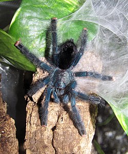
 Bullet ants have an extremely painful sting
 -
 Parrots at clay lick in Yasuni National Park, Ecuador
 -
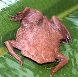 Pipa pipa, a species of frog found within the Amazon.
 -
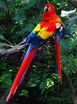 Scarlet macaw, indigenous to the American tropics.
 -
 Titan Beetle is most generally associated with the Amazon Rainforest, it may also be found in other parts of South America if ecological conditions are favorable


_over_40_cm_long_-_Preserved_Specimen.jpg)

.jpg)
.JPG)
_(9714001143).jpg)
_Edit.jpg)


.jpg)


Deforestation
[edit]
.jpg)
.jpg)


Deforestation is the conversion of forested areas to non-forested areas. The main sources of deforestation in the Amazon are human settlement and the development of the land.[68] In 2022, about 20% of the Amazon rainforest has already been deforested and a further 6% was "highly degraded".[69] Research suggests that upon reaching about 20–25% (hence 0–5% more), the tipping point to flip it into a non-forest ecosystem – degraded savannah – (in eastern, southern and central Amazonia) will be reached.[70][71][72] This process of savanisation would take decades to take full effect.[69]
Prior to the early 1960s, access to the forest's interior was highly restricted, and the forest remained basically intact.[73] Farms established during the 1960s were based on crop cultivation and the slash and burn method. However, the colonists were unable to manage their fields and the crops because of the loss of soil fertility and weed invasion.[74] The soils in the Amazon are productive for just a short period of time, so farmers are constantly moving to new areas and clearing more land.[74] These farming practices led to deforestation and caused extensive environmental damage.[75] Deforestation is considerable, and areas cleared of forest are visible to the naked eye from outer space.
In the 1970s, construction began on the Trans-Amazonian highway. This highway represented a major threat to the Amazon rainforest.[76] The highway still has not been completed, limiting the environmental damage.
Between 1991 and 2000, the total area of forest lost in the Amazon rose from 415,000 to 587,000 km2 (160,000 to 227,000 sq mi), with most of the lost forest becoming pasture for cattle.[77] Seventy percent of formerly forested land in the Amazon, and 91% of land deforested since 1970, have been used for livestock pasture.[78][79] Currently, Brazil is the largest global producer of soybeans. New research however, conducted by Leydimere Oliveira et al., has shown that the more rainforest is logged in the Amazon, the less precipitation reaches the area and so the lower the yield per hectare becomes. So despite the popular perception, there has been no economical advantage for Brazil from logging rainforest zones and converting these to pastoral fields.[80]

The needs of soy farmers have been used to justify many of the controversial transportation projects that are currently developing in the Amazon. The first two highways successfully opened up the rainforest and led to increased settlement and deforestation. The mean annual deforestation rate from 2000 to 2005 (22,392 km2 or 8,646 sq mi per year) was 18% higher than in the previous five years (19,018 km2 or 7,343 sq mi per year).[81] Although deforestation declined significantly in the Brazilian Amazon between 2004 and 2014, there has been an increase to the present day.[82]

Brazil's President, Jair Bolsonaro, has supported the relaxation of regulations placed on agricultural land. He has used his time in office to allow for more deforestation and more exploitation of the Amazon's rich natural resources. Deforestation reached a 15 year high in 2021.[83]
Since the discovery of fossil fuel reservoirs in the Amazon rainforest, oil drilling activity has steadily increased, peaking in the Western Amazon in the 1970s and ushering another drilling boom in the 2000s.[84] Oil companies have to set up their operations by opening new roads through the forests, which often contributes to deforestation in the region.[85] 9.4% of the territory of the Amazon is affected by oil fields.[86]
Mining is also a major driver of deforestation. 17% of the area of the Amazon Rainforest is affected by mining.[86]
The transition to solar and wind energy, digitalization, raised the demand for cassiterite (the main ore of tin used also for financing gold mining), manganese and copper, which attracrted many illegal miners to the Amazon. This led to deforestation, different environmental and social problems. Hydropower also creates significant problems in the Amazon. Such activities are defined by the World Rainforest Movement as "Green extractivism".[87][88]
The European Union–Mercosur free trade agreement, which would form one of the world's largest free trade areas, has been denounced by environmental activists and indigenous rights campaigners.[89] The fear is that the deal could lead to more deforestation of the Amazon rainforest as it expands market access to Brazilian beef.[90]
According to a November 2021 report by Brazil's INPE, based on satellite data, deforestation has increased by 22% over 2020 and is at its highest level since 2006.[91][92]
2019 fires
[edit]There were 72,843 fires in Brazil in 2019, with more than half within the Amazon region.[93][94][95] In August 2019 there were a record number of fires.[96] Deforestation in the Brazilian Amazon rose more than 88% in June 2019 compared with the same month in 2018.[97]
-
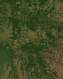 NASA satellite observation of deforestation in the Mato Grosso state of Brazil. The transformation from forest to farm is evident by the paler square shaped areas under development.
 -
 Fires and deforestation in the state of Rondônia
 -
 One consequence of forest clearing in the Amazon: thick smoke that hangs over the forest
 -
 Impact of deforestation on natural habitat of trees


The increased area of fire-impacted forest coincided with a relaxation of environmental regulations from the Brazilian government. Notably, before those regulations were put in place in 2008 the fire-impacted area was also larger compared to the regulation period of 2009–2018. As these fire continue to move closer to the heart of the Amazon basin, their impact on biodiversity will only increase in scale, as the cumulative fire-impacted area is correlated with the number of species impacted.[65]
Conservation and climate change
[edit].jpg)
Environmentalists are concerned about loss of biodiversity that will result from destruction of the forest, and also about the release of the carbon contained within the vegetation, which could accelerate global warming. Amazonian evergreen forests account for about 10% of the world's terrestrial primary productivity and 10% of the carbon stores in ecosystems[98] – of the order of 1.1 × 10¹¹ metric tonnes of carbon.[99] Amazonian forests are estimated to have accumulated 0.62 ± 0.37 tons of carbon per hectare per year between 1975 and 1996.[99] In 2021 it was reported that the Amazon for the first time emitted more greenhouse gases than it absorbed.[100] Though often referenced as producing more than a quarter of the Earth's oxygen, this often stated, but misused statistic actually refers to oxygen turnover. The net contribution of the ecosystem is approximately zero.[101]

One computer model of future climate change caused by greenhouse gas emissions shows that the Amazon rainforest could become unsustainable under conditions of severely reduced rainfall and increased temperatures, leading to an almost complete loss of rainforest cover in the basin by 2100.,[103][104] and severe economic, natural capital and ecosystem services impacts of not averting the tipping point.[105] However, simulations of Amazon basin climate change across many different models are not consistent in their estimation of any rainfall response, ranging from weak increases to strong decreases.[106] The result indicates that the rainforest could be threatened through the 21st century by climate change in addition to deforestation.

In 1989, environmentalist C.M. Peters and two colleagues stated there is economic as well as biological incentive to protecting the rainforest. One hectare in the Peruvian Amazon has been calculated to have a value of $6820 if intact forest is sustainably harvested for fruits, latex, and timber; $1000 if clear-cut for commercial timber (not sustainably harvested); or $148 if used as cattle pasture.[107]

As indigenous territories continue to be destroyed by deforestation and ecocide (such as in the Peruvian Amazon),[108] indigenous peoples' rainforest communities continue to disappear, while others, like the Urarina continue to struggle to fight for their cultural survival and the fate of their forested territories. Meanwhile, the relationship between non-human primates in the subsistence and symbolism of indigenous lowland South American peoples has gained increased attention, as have ethno-biology and community-based conservation efforts.
From 2002 to 2006, the conserved land in the Amazon rainforest almost tripled and deforestation rates dropped up to 60%. About 1,000,000 km2 (250,000,000 acres) have been put onto some sort of conservation, which adds up to a current amount of 1,730,000 km2 (430,000,000 acres).[109]
In April 2019, the Ecuadorian court stopped oil exploration activities in 180,000 hectares (440,000 acres) of the Amazon rainforest.[110]
In July 2019, the Ecuadorian court forbade the government to sell territory with forests to oil companies.[111]
In September 2019, the US and Brazil agreed to promote private-sector development in the Amazon. They also pledged a $100m biodiversity conservation fund for the Amazon led by the private sector. Brazil's foreign minister stated that opening the rainforest to economic development was the only way to protect it.[112]
-
 Anthropogenic emission of greenhouse gases broken down by sector for the year 2000.
 -
 Aerosols over the Amazon each September for four burning seasons (2005 through 2008). The aerosol scale (yellow to dark reddish-brown) indicates the relative amount of particles that absorb sunlight.
 -
 Aerial roots of red mangrove on an Amazonian river.
 -
![Climate change disturbances of rainforests.[113]](//upload.wikimedia.org/wikipedia/commons/thumb/1/1b/Climate_change_disturbances_of_rainforests_infographic.jpg/250px-Climate_change_disturbances_of_rainforests_infographic.jpg) Climate change disturbances of rainforests.[113]
Climate change disturbances of rainforests.[113]


![Climate change disturbances of rainforests.[113]](https://en.wikipedia.org/wiki/File:Climate_change_disturbances_of_rainforests_infographic.jpg)
A 2009 study found that a 4 °C rise (above pre-industrial levels) in global temperatures by 2100 would kill 85% of the Amazon rainforest while a temperature rise of 3 °C would kill some 75% of the Amazon.[114]

A new study by an international team of environmental scientists in the Brazilian Amazon shows that protection of freshwater biodiversity can be increased by up to 600% through integrated freshwater-terrestrial planning .[115]
Deforestation in the Amazon rainforest region has a negative impact on local climate.[116] It was one of the main causes of the severe drought of 2014–2015 in Brazil.[117][118] This is because the moisture from the forests is important to the rainfall in Brazil, Paraguay and Argentina. Half of the rainfall in the Amazon area is produced by the forests.[119]
Results of a 2021 scientific synthesis indicate that, in terms of global warming, the Amazon basin with the Amazon rainforest is currently emitting more greenhouse gases than it absorbs overall. Climate change impacts and human activities in the area – mainly wildfires, current land-use and deforestation – are causing a release of forcing agents that likely result in a net warming effect.[120][113][121]
In 2022 the supreme court of Ecuador decided that ""under no circumstances can a project be carried out that generates excessive sacrifices to the collective rights of communities and nature." It also required the government to respect the opinion of Indigenous peoples of the Americas about different industrial projects on their land. Advocates of the decision argue that it will have consequences far beyond Ecuador. In general, ecosystems are in better shape when indigenous peoples own or manage the land.[122]
Due to the conservation policies of Luiz Inácio Lula da Silva in the first 10 months of 2023 deforestation in the Brazilian Amazon decreased by around 50% compared to the same period in 2022. This was despite a severe drought, one of the worst on record, that exacerbated the situation. Climate change, El Nino, deforestation increases the likelihood of drought condition in the Amazon.[123]
According to Amazon Conservation's MAAP forest monitoring program, the deforestation rate in the Amazon from the January 1 to November 8, 2023, decreased by 56% in comparison to the same period in 2022. The main cause is the decline in deforestation rate in Brazil, due to the government's policies, while Columbia, Peru and Bolivia also reduced deforestation.[124]
In January 2024 published data showed a 50% decline in deforestation rate in the Amazon rainforest and 43% rise in vegetation loss in the neighbor Cerrado during the year of 2023 in comparison to 2022. Both biomes together lose 12,980 km², 18% less than in 2022.[125]
Remote sensing
[edit]
The use of remotely sensed data is dramatically improving conservationists' knowledge of the Amazon basin. Given the objectivity and lowered costs of satellite-based land cover and -change analysis, it appears likely that remote sensing technology will be an integral part of assessing the extents, locations and damage of deforestation in the basin.[126] Furthermore, remote sensing is the best and perhaps only possible way to study the Amazon on a large scale.[127]
The use of remote sensing for the conservation of the Amazon is also being used by the indigenous tribes of the basin to protect their tribal lands from commercial interests. Using handheld GPS devices and programs like Google Earth, members of the Trio Tribe, who live in the rainforests of southern Suriname, map out their ancestral lands to help strengthen their territorial claims.[128] Currently, most tribes in the Amazon do not have clearly defined boundaries, making it easier for commercial ventures to target their territories.
To accurately map the Amazon's biomass and subsequent carbon-related emissions, the classification of tree growth stages within different parts of the forest is crucial. In 2006, Tatiana Kuplich organized the trees of the Amazon into four categories: mature forest, regenerating forest [less than three years], regenerating forest [between three and five years of regrowth], and regenerating forest [eleven to eighteen years of continued development].[129] The researcher used a combination of synthetic aperture radar (SAR) and Thematic Mapper (TM) to accurately place the different portions of the Amazon into one of the four classifications.
Impact of early 21st-century Amazon droughts
[edit]In 2005, parts of the Amazon basin experienced the worst drought in one hundred years,[130] and there were indications that 2006 may have been a second successive year of drought.[131] A 2006 article in the UK newspaper The Independent reported the Woods Hole Research Center results, showing that the forest in its present form could survive only three years of drought.[132][133] Scientists at the Brazilian National Institute of Amazonian Research argued in the article that this drought response, coupled with the effects of deforestation on regional climate, are pushing the rainforest towards a "tipping point" where it would irreversibly start to die.[134] It concluded that the forest is on the brink of[vague] being turned into savanna or desert, with catastrophic consequences for the world's climate.[citation needed] A study published in Nature Communications in October 2020 found that about 40% of the Amazon rainforest is at risk of becoming a savanna-like ecosystem due to reduced rainfall.[135] A study published in Nature climate change provided direct empirical evidence that more than three-quarters of the Amazon rainforest has been losing resilience since the early 2000s, risking dieback with profound implications for biodiversity, carbon storage and climate change at a global scale.[136] Research from 2025 using hundreds of climate-model simulations says even passing 1.5C of global warming temporarily would trigger a significant risk of Amazon forest dieback.[137][138]
According to the World Wide Fund for Nature, the combination of climate change and deforestation increases the drying effect of dead trees that fuels forest fires.[139]
In 2010, the Amazon rainforest experienced another severe drought, in some ways more extreme than the 2005 drought. The affected region was approximately 3,000,000 km2 (1,160,000 sq mi) of rainforest, compared with 1,900,000 km2 (734,000 sq mi) in 2005. The 2010 drought had three epicenters where vegetation died off, whereas in 2005, the drought was focused on the southwestern part. The findings were published in the journal Science. In a typical year, the Amazon absorbs 1.5 gigatons of carbon dioxide; during 2005 instead 5 gigatons were released and in 2010 8 gigatons were released.[140][141] Additional severe droughts occurred in 2010, 2015, and 2016.[142]
In 2019 Brazil's protections of the Amazon rainforest were slashed, resulting in a severe loss of trees.[143] According to Brazil's National Institute for Space Research (INPE), deforestation in the Brazilian Amazon rose more than 50% in the first three months of 2020 compared to the same three-month period in 2019.[144]
In 2020, a 17 percent rise was noted in the Amazon wildfires, marking the worst start to the fire season in a decade. The first 10 days of August 2020 witnessed 10,136 fires. An analysis of the government figures reflected 81 per cent increase in fires in federal reserves, in comparison with the same period in 2019.[145] However, President Jair Bolsonaro turned down the existence of fires, calling it a "lie", despite the data produced by his own government.[146] Satellites in September recorded 32,017 hotspots in the world's largest rainforest, a 61% rise from the same month in 2019.[147] In addition, October saw a huge surge in the number of hotspots in the forest (more than 17,000 fires are burning in the Amazon's rainforest) – with more than double the amount detected in the same month last year.[148]
Possibility of forest-friendly economy
[edit]Experts consider a forest-friendly economy the best method to sustain the Brazilian agricultural sector, because deforestation disrupts rainfall patterns and increases temperatures, hurting agriculture. This may lead to "agro-suicide." Even irrigation can not solve the problem, because for irrigation farmers need water, which is already in short supply.[149]
In 2023 the World Bank, published a report named: "A Balancing Act for Brazil's Amazonian States: An Economic Memorandum". The report stating that economic losses due to deforestation in Brazil could reach around 317 billion dollars per year, approximately 7 times higher in comparison to the cost of all commodities produced through deforestation, proposed non-deforestation based economic program in the region of the Amazon rainforest.[7][8]

Silvopasture (integrating trees, forage and grazing) can help to stop deforestation in the region.[150]
According to WWF, ecotourism could help the Amazon to reduce deforestation and climate change. Ecotourism is currently still little practiced in the Amazon, partly due to lack of information about places where implementation is possible. Ecotourism is a sector that can also be taken up by the Indigenous community in the Amazon as a source of income and revenue. An ecotourism project in the Brazilian section of the rainforest had been under consideration by Brazil's State Secretary for the Environment and Sustainable Development in 2009, along the Aripuanã River, in the Aripuanã Sustainable Development Reserve.[151] Also, some community-based ecotourism exists in the Mamirauá Sustainable Development Reserve.[152] Ecotourism is also practiced in the Peruvian section of the rainforest. A few ecolodges are for instance present between Cusco and Madre de Dios.[153]
In May 2023 Brazil's bank federation decided to implement a new sustainability standard demanding from meatpackers to ensure their meat is not coming from illegally deforested area. Credits will not be given to those who will not meet the new standards. The decision came after the European Union decides to implement regulations to stop deforestation. Brazil beef exporters, said the standard is not just because it is not applied to land owners.[154] 21 banks representing 81% of the credit market in Brazil agree to follow those rules.[155]
According to a statement of the Colombian government deforestation rates in the Colombian Amazon fell by 70% in the first 9 months of 2023 compared to the same period in the previous year, what can be attributed to the conservation policies of the government. One of them is paying local residents for conserving the forest.[156]
See also
[edit]- Organizations
- Technology
- Amazon Surveillance System (Sistema de Vigilância da Amazônia)
- Global Forest Watch
Notes
[edit]- ^ Portuguese: Floresta amazônica or Amazônia; Spanish: Selva amazónica, Amazonía, or usually Amazonia; French: Forêt amazonienne; Dutch: Amazoneregenwoud. In English, the names are sometimes capitalized further, as Amazon Rainforest, Amazon Forest, or Amazon Jungle.
- ^ Many are caboclos or mestiço (mixed-race), also called pardos, descendants of Amazonian indigenous people and white Portuguese colonizers. Despite their indigenous ancestry, they no longer identify with any indigenous ethnicity.
References
[edit]- ^ "WWF – About the Amazon". Archived from the original on October 7, 2019. Retrieved October 11, 2019.
- ^ "Amazon River". britannica.com. Encyclopaedia Britannica. January 11, 2024.
- ^ "Amazon Rainforest". britannica.com. Encyclopaedia Britannica. May 30, 2024.
- ^ "WNF: Places: Amazon". Archived from the original on April 13, 2020. Retrieved June 4, 2016.
- ^ a b "Field Museum scientists estimate 16,000 tree species in the Amazon". Field Museum. October 17, 2013. Archived from the original on December 7, 2019. Retrieved October 18, 2013.
- ^ "Inside the Amazon". Archived from the original on October 7, 2019. Retrieved November 5, 2020.
- ^ a b "World Bank: Brazil faces $317 billion in annual losses to Amazon deforestation". 8.9ha. World Bank. May 24, 2023. Retrieved May 30, 2023.
- ^ a b "A Balancing Act for Brazil's Amazonian States: An Economic Memorandum." Executive Summary booklet. The World Bank. 2023. Retrieved May 30, 2023.
- ^ Potter, Hyury (November 28, 2024). "Rainforest Payback: How deforestation fails agriculture in the Amazon". Rainforest Foundation Norway. Retrieved August 3, 2025.
- ^ a b Taylor, Isaac (1898). Names and Their Histories: A Handbook of Historical Geography and Topographical Nomenclature. London: Rivingtons. ISBN 978-0-559-29668-0. Archived from the original on July 25, 2020. Retrieved October 12, 2008.
{{cite book}}: ISBN / Date incompatibility (help) - ^ "Yanomami". Encyclopaedia Britannica. Archived from the original on July 25, 2020. Retrieved June 20, 2020.
- ^ Roosevelt, A.C.; da Costa, M. Lima; Machado, C. Lopes; Michab, M.; Mercier, N.; Valladas, H.; Feathers, J.; Barnett, W.; da Silveira, M. Imazio; Henderson, A.; Sliva, J.; Chernoff, B.; Reese, D.S.; Holman, J.A.; Toth, N.; Schick, K. (April 19, 1996). "Paleoindian Cave Dwellers in the Amazon: The Peopling of the Americas". Science. 272 (5260): 373–384. Bibcode:1996Sci...272..373R. doi:10.1126/science.272.5260.373. S2CID 129231783.
- ^ Heckenberger, Michael J.; Kuikuro, Afukaka; Kuikuro, Urissapá Tabata; Russell, J. Christian; Schmidt, Morgan; Fausto, Carlos; Franchetto, Bruna (September 19, 2003). "Amazonia 1492: Pristine Forest or Cultural Parkland?". Science. 301 (5640): 1710–1714. Bibcode:2003Sci...301.1710H. doi:10.1126/science.1086112. PMID 14500979. S2CID 7962308.
- ^ Meggers, Betty J. (December 19, 2003). "Revisiting Amazonia Circa 1492". Science. 302 (5653): 2067–2070. doi:10.1126/science.302.5653.2067b. PMID 14684803. S2CID 5316715.
- ^ Margolis, Mac (February 6, 2025). "Lost cities of the Amazon: how science is revealing ancient garden towns hidden in the rainforest". The Guardian. ISSN 0261-3077. Retrieved March 1, 2025.
- ^ Yuhas, Alan; Jiménez, Jesus (January 23, 2024). "Remnants of Sprawling Ancient Cities Are Found in the Amazon". The New York Times. ISSN 0362-4331. Retrieved July 6, 2024.
- ^ a b Chris C. Park (2003). Tropical Rainforests. Routledge. p. 108. ISBN 978-0-415-06239-8. Archived from the original on January 10, 2022. Retrieved August 24, 2017.
- ^ Clement, Charles R.; Denevan, William M.; Heckenberger, Michael J.; Junqueira, André Braga; Neves, Eduardo G.; Teixeira, Wenceslau G.; Woods, William I. (August 7, 2015). "The domestication of Amazonia before European conquest". Proceedings of the Royal Society B: Biological Sciences. 282 (1812) 20150813. doi:10.1098/rspb.2015.0813. ISSN 0962-8452. PMC 4528512. PMID 26202998.
- ^ Smith, A (1994). Explorers of the Amazon. Chicago: University of Chicago Press. ISBN 978-0-226-76337-8.
- ^ a b c "Unnatural Histories – Amazon". BBC Four. Archived from the original on January 8, 2020. Retrieved May 9, 2012.
- ^ Simon Romero (January 14, 2012). "Once Hidden by Forest, Carvings in Land Attest to Amazon's Lost World". The New York Times. Archived from the original on December 26, 2019. Retrieved February 26, 2017.
- ^ Martti Pärssinen; Denise Schaan; Alceu Ranzi (2009). "Pre-Columbian geometric earthworks in the upper Purús: a complex society in western Amazonia". Antiquity. 83 (322): 1084–1095. doi:10.1017/s0003598x00099373. S2CID 55741813.
- ^ Junior, Gonçalo (October 2008). "Amazonia lost and found". Pesquisa (Ed.220). Archived from the original on August 12, 2014.
- ^ The influence of human alteration has been generally underestimated, reports Darna L. Dufour: "Much of what has been considered natural forest in Amazonia is probably the result of hundreds of years of human use and management." "Use of Tropical Rainforests by Native Amazonians," BioScience 40, no. 9 (October 1990):658. For an example of how such peoples integrated planting into their nomadic lifestyles, see Rival, Laura (1993). "The Growth of Family Trees: Understanding Huaorani Perceptions of the Forest". Man. 28 (4): 635–652. doi:10.2307/2803990. JSTOR 2803990.
- ^ Heckenberger, M.J.; Kuikuro, A; Kuikuro, UT; Russell, JC; Schmidt, M; Fausto, C; Franchetto, B (September 19, 2003), "Amazonia 1492: Pristine Forest or Cultural Parkland?", Science, vol. 301, no. 5640 (published 2003), pp. 1710–14, Bibcode:2003Sci...301.1710H, doi:10.1126/science.1086112, PMID 14500979, S2CID 7962308
- ^ "The Amazon's head hunters and body shrinkers". The Week. January 20, 2012. Archived from the original on October 13, 2018. Retrieved September 12, 2019.
- ^ Chagnon, Napoleon A. (1992). Yanomamo. New York: Holt, Rinehart, and Winston.
- ^ "Mundurukú people". britannica.com. Encyclopaedia Britannica.
- ^ Heckenberger, Michael (2005). The Ecology of Power: Culture, Place, and Personhood in the Southern Amazon, A.D. 1000-2000. Routledge. pp. 139–141. ISBN 978-0-415-94599-8.
- ^ Davie, Maurice R. (1929). The Evolution of War: A Study of Its Role in Early Societies. Yale University Press. p. 251. ISBN 978-0-486-16221-8.
{{cite book}}: ISBN / Date incompatibility (help) - ^ La Republica Oligarchic. Editorial Lexus 2000 p. 925.
- ^ From the first expedition to the creation of the Park, pib.socioambiental.org
- ^ "Rain delays rescue of explorers". The Herald. Glasgow, Scotland. September 8, 1961. p. 8 – via Google News.
- ^ Snell, Ron (February 2, 2006). Jungle Calls (Kindle ed.). Garland, Texas: Hannibal Books. ISBN 0-929292-86-3. Retrieved May 27, 2020.
- ^ Coca-Castro, Alejandro; Reymondin, Louis; Bellfield, Helen; Hyman, Glenn (January 2013), Land use Status and Trends in Amazonia (PDF), Amazonia Security Agenda Project, archived from the original (PDF) on March 19, 2016, retrieved August 25, 2019
- ^ Morley, Robert J. (2000). Origin and Evolution of Tropical Rain Forests. Wiley. ISBN 978-0-471-98326-2.
- ^ Burnham, Robyn J.; Johnson, Kirk R. (2004). "South American palaeobotany and the origins of neotropical rainforests". Philosophical Transactions of the Royal Society. 359 (1450): 1595–1610. doi:10.1098/rstb.2004.1531. PMC 1693437. PMID 15519975.
- ^ Maslin, Mark; Malhi, Yadvinder; Phillips, Oliver; Cowling, Sharon (2005). "New views on an old forest: assessing the longevity, resilience and future of the Amazon rainforest" (PDF). Transactions of the Institute of British Geographers. 30 (4): 477–499. Bibcode:2005TrIBG..30..477M. doi:10.1111/j.1475-5661.2005.00181.x. Archived from the original (PDF) on October 1, 2008. Retrieved September 25, 2008.
- ^ Malhi, Yadvinder; Phillips, Oliver (2005). Tropical Forests & Global Atmospheric Change. Oxford University Press. ISBN 978-0-19-856706-6.
- ^ Costa, João Batista Sena; Bemerguy, Ruth Léa; Hasui, Yociteru; Borges, Maurício da Silva (2001). "Tectonics and paleogeography along the Amazon river". Journal of South American Earth Sciences. 14 (4): 335–347. Bibcode:2001JSAES..14..335C. doi:10.1016/S0895-9811(01)00025-6.
- ^ Milani, Edison José; Zalán, Pedro Victor (1999). "An outline of the geology and petroleum systems of the Paleozoic interior basins of South America". Episodes. 22 (3): 199–205. doi:10.18814/epiiugs/1999/v22i3/007.
- ^ Colinvaux, Paul A.; Oliveira, Paulo E. De (2000). "Palaeoecology and climate of the Amazon basin during the last glacial cycle". Journal of Quaternary Science. 15 (4): 347–356. Bibcode:2000JQS....15..347C. doi:10.1002/1099-1417(200005)15:4<347::AID-JQS537>3.0.CO;2-A.
- ^ Van Der Hammen, Thomas; Hooghiemstra, Henry (2000). "Neogene and Quaternary history of vegetation, climate, and plant diversity in Amazonia". Quaternary Science Reviews. 19 (8): 725. Bibcode:2000QSRv...19..725V. CiteSeerX 10.1.1.536.519. doi:10.1016/S0277-3791(99)00024-4.
- ^ Colinvaux, P.A.; De Oliveira, P.E.; Bush, M.B. (January 2000). "Amazonian and neotropical plant communities on glacial time-scales: The failure of the aridity and refuge hypotheses". Quaternary Science Reviews. 19 (1–5): 141–169. Bibcode:2000QSRv...19..141C. doi:10.1016/S0277-3791(99)00059-1.
- ^ Yu, Hongbin (2015). "The fertilizing role of African dust in the Amazon rainforest: A first multiyear assessment based on data from Cloud-Aerosol Lidar and Infrared Pathfinder Satellite Observations". Geophysical Research Letters. 42 (6): 1984–1991. Bibcode:2015GeoRL..42.1984Y. doi:10.1002/2015GL063040.
- ^ Garner, Rob (February 24, 2015). "Saharan Dust Feeds Amazon's Plants". NASA. Archived from the original on June 23, 2019. Retrieved June 20, 2019.
- ^ "Desert Dust Feeds Amazon Forests – NASA Science". nasa.gov. April 28, 2015. Archived from the original on May 14, 2017. Retrieved July 12, 2017.
- ^ Barkley, Anne E.; Prospero, Joseph M.; Mahowald, Natalie; Hamilton, Douglas S.; Popendorf, Kimberly J.; Oehlert, Amanda M.; Pourmand, Ali; Gatineau, Alexandre; Panechou-Pulcherie, Kathy; Blackwelder, Patricia; Gaston, Cassandra J. (August 13, 2019). "African biomass burning is a substantial source of phosphorus deposition to the Amazon, Tropical Atlantic Ocean, and Southern Ocean". Proceedings of the National Academy of Sciences. 116 (33): 16216–16221. Bibcode:2019PNAS..11616216B. doi:10.1073/pnas.1906091116. PMC 6697889. PMID 31358622.
- ^ "Smoke from Africa fertilizes the Amazon and tropical ocean regions with soluble phosphorous [sic]". phys.org. Archived from the original on August 14, 2019. Retrieved August 14, 2019.
- ^ Turner, I.M. (2001). The ecology of trees in the tropical rain forest. Cambridge University Press, Cambridge. ISBN 0-521-80183-4[page needed]
- ^ "Amazon Rainforest, Amazon Plants, Amazon River Animals". World Wide Fund for Nature. Archived from the original on May 17, 2008. Retrieved May 6, 2008.
- ^ Weisberger, Mindy (March 26, 2024). "Ancient giant dolphin discovered in the Amazon". CNN. Retrieved March 29, 2024.
- ^ "Photos / Pictures of the Amazon Rainforest". Travel.mongabay.com. Archived from the original on December 17, 2008. Retrieved December 18, 2008.
- ^ "Rainforest". National Geographic.
- ^ James S. Albert; Roberto E. Reis (March 8, 2011). Historical Biogeography of Neotropical Freshwater Fishes. University of California Press. p. 308. Archived from the original on June 30, 2011. Retrieved June 28, 2011.
- ^ Da Silva; Jose Maria Cardoso; et al. (2005). "The Fate of the Amazonian Areas of Endemism". Conservation Biology. 19 (3): 689–694. Bibcode:2005ConBi..19..689D. doi:10.1111/j.1523-1739.2005.00705.x. S2CID 85843442.
- ^ Lewinsohn, Thomas M.; Paulo Inácio Prado (June 2005). "How Many Species Are There in Brazil?". Conservation Biology. 19 (3): 619–624. Bibcode:2005ConBi..19..619L. doi:10.1111/j.1523-1739.2005.00680.x. S2CID 84691981.
- ^ Wright, S. Joseph (October 12, 2001). "Plant diversity in tropical forests: a review of mechanisms of species coexistence". Oecologia. 130 (1): 1–14. Bibcode:2002Oecol.130....1W. doi:10.1007/s004420100809. PMID 28547014. S2CID 4863115.
- ^ Laurance, William F.; Fearnside, Philip M.; Laurance, Susan G.; Delamonica, Patricia; Lovejoy, Thomas E.; Rankin-de Merona, Judy M.; Chambers, Jeffrey Q.; Gascon, Claude (June 14, 1999). "Relationship between soils and Amazon forest biomass: a landscape-scale study". Forest Ecology and Management. 118 (1–3): 127–138. Bibcode:1999ForEM.118..127L. doi:10.1016/S0378-1127(98)00494-0.
- ^ "Amazon Rainforest". South AmericaTravel Guide. Archived from the original on August 12, 2008. Retrieved August 19, 2008.
- ^ Mynenia, Ranga B.; et al. (March 13, 2007). "Large seasonal swings in leaf area of Amazon rainforests". Proceedings of the National Academy of Sciences. 104 (12): 4820–4823. Bibcode:2007PNAS..104.4820M. doi:10.1073/pnas.0611338104. PMC 1820882. PMID 17360360.
- ^ Costa, Camilla (May 21, 2020). "Amazon under threat: Fires, loggers and now virus". BBC. Retrieved November 14, 2023.
- ^ "Piranha 'less deadly than feared'". BBC News. July 2, 2007. Archived from the original on July 7, 2007. Retrieved July 2, 2007.
- ^ da Rosa; Elizabeth S. T.; et al. (August 2006). "Bat-transmitted Human Rabies Outbreaks, Brazilian Amazon". Emerging Infectious Diseases. 12 (8): 1197–1202. doi:10.3201/eid1708.050929. PMC 3291204. PMID 16965697.
- ^ a b Feng, Xiao; Merow, Cory; Liu, Zhihua; Park, Daniel S.; Roehrdanz, Patrick R.; Maitner, Brian; Newman, Erica A.; Boyle, Brad L.; Lien, Aaron; Burger, Joseph R.; Pires, Mathias M. (September 1, 2021). "How deregulation, drought and increasing fire impact Amazonian biodiversity". Nature. 597 (7877): 516–521. Bibcode:2021Natur.597..516F. doi:10.1038/s41586-021-03876-7. ISSN 1476-4687. PMID 34471291. S2CID 237388791. Archived from the original on September 12, 2021. Retrieved September 11, 2021.
- ^ ● 2021 data: "Forest Pulse: The Latest on the World's Forests". WRI.org. World Resources Institute. June 2023. Archived from the original on June 27, 2023.
● 2022 and 2023 data: "Forest Pulse: The Latest on the World's Forests". WRI.org. World Resources Institute / Global Forest Review. April 4, 2024. Archived from the original on April 4, 2024.
● 2024 data: Goldman, Elizabeth; Carter, Sarah; Sims, Michelle (May 21, 2025). "Fires Drove Record-breaking Tropical Forest Loss in 2024". World Resources Institute. Archived from the original on May 26, 2025. - ^ "Amazon Against the Clock: A Regional Assessment on Where and How to Protect 80% by 2025" (PDF). Amazon Watch. September 2022. p. 8. Archived (PDF) from the original on September 10, 2022.
Graphic 2: Current State of the Amazon by country, by percentage / Source: RAISG (Red Amazónica de Información Socioambiental Georreferenciada) Elaborated by authors.
- ^ Various (2001). Bierregaard, Richard; Gascon, Claude; Lovejoy, Thomas E.; Mesquita, Rita (eds.). Lessons from Amazonia: The Ecology and Conservation of a Fragmented Forest. Yale University Press. ISBN 978-0-300-08483-2.
- ^ a b Tandon, Ayesha (October 4, 2023). "Drying of Amazon could be early warning of 'tipping point' for the rainforest". Carbon Brief. Retrieved October 6, 2023.
- ^ "Amazon Rainforest 'heading to point of no return'". February 22, 2018. Archived from the original on September 22, 2020. Retrieved July 6, 2019.
- ^ Lovejoy, Thomas E.; Nobre, Carlos (2018). "Amazon Tipping Point". Science Advances. 4 (2) eaat2340. Bibcode:2018SciA....4.2340L. doi:10.1126/sciadv.aat2340. PMC 5821491. PMID 29492460.
- ^ Bochow, Nils; Boers, Niklas (October 6, 2023). "The South American monsoon approaches a critical transition in response to deforestation". Science Advances. 9 (40) eadd9973. Bibcode:2023SciA....9D9973B. doi:10.1126/sciadv.add9973. ISSN 2375-2548. PMC 10550231. PMID 37792950.
- ^ Kirby, Kathryn R.; Laurance, William F.; Albernaz, Ana K.; Schroth, Götz; Fearnside, Philip M.; Bergen, Scott; M. Venticinque, Eduardo; Costa, Carlos da (2006). "The future of deforestation in the Brazilian Amazon" (PDF). Futures. 38 (4): 432–453. CiteSeerX 10.1.1.573.1317. doi:10.1016/j.futures.2005.07.011. Archived (PDF) from the original on July 22, 2018. Retrieved October 27, 2017.
- ^ a b Watkins and Griffiths, J. (2000). Forest Destruction and Sustainable Agriculture in the Brazilian Amazon: a Literature Review (Doctoral dissertation, The University of Reading, 2000). Dissertation Abstracts International, 15–17
- ^ Williams, M. (2006). Deforesting the Earth: From Prehistory to Global Crisis (Abridged ed.). Chicago: The University of Chicago Press. ISBN 978-0-226-89947-3.
- ^ "Impacts and Causes of Deforestation in the Amazon Basin". kanat.jsc.vsc.edu. Archived from the original on June 15, 2013. Retrieved March 6, 2013.
- ^ Centre for International Forestry Research (CIFOR) (2004)
- ^ Steinfeld, Henning; Gerber, Pierre; Wassenaar, T.D.; Castel, Vincent (2006). Livestock's Long Shadow: Environmental Issues and Options. Food and Agriculture Organization of the United Nations. ISBN 978-92-5-105571-7. Archived from the original on July 26, 2008. Retrieved August 19, 2008.
- ^ Margulis, Sergio (2004). Causes of Deforestation of the Brazilian Amazon (PDF). World Bank Working Paper No. 22. Washington, DC: The World Bank. ISBN 978-0-8213-5691-3. Archived (PDF) from the original on September 10, 2008. Retrieved September 4, 2008.
- ^ "Research paper of Leydimere Oliveira on the amazon". Archived from the original on August 3, 2013.
- ^ Barreto, P.; Souza Jr. C.; Noguerón, R.; Anderson, A. & Salomão, R. 2006. Human Pressure on the Brazilian Amazon Forests[permanent dead link]. Imazon. Retrieved September 28, 2006. (The Imazon Archived September 1, 2004, at the Wayback Machine web site contains many resources relating to the Brazilian Amazonia.)
- ^ "INPE: Estimativas Anuais desde 1988 até 2009". inpe.br. Archived from the original on November 30, 2010. Retrieved November 3, 2010.
- ^ Diana, Roy. "Deforestation of Brazil's Amazon Has Reached a Record High. What's Being Done?". Retrieved November 2, 2024.
- ^ "Oil Drilling Contaminated Western Amazon". livesciences.com. June 13, 2014. Archived from the original on February 18, 2019. Retrieved February 17, 2019.
- ^ "Oil and Gas Extraction in the Amazon". wwf.panda.org. Archived from the original on February 18, 2019. Retrieved February 17, 2019.
- ^ a b Sierra Praeli, Yvette (October 3, 2022). "The Amazon will reach tipping point if current trend of deforestation continues". Mongabay. Amazon Network of Georeferenced Socio-Environmental Information (RAISG). Retrieved August 22, 2024.
- ^ "How different forms of 'green' extractivism are causing the destruction of the Amazon forest". World Rainforest Movement. Retrieved August 20, 2024.
- ^ Cowie, Sam (August 2, 2024). "The lawless mining gangs targeting the Amazon's precious green energy minerals". The Guardian. Retrieved August 20, 2024.
- ^ "EU urged to halt trade talks with S. America over Brazil abuses". France 24. June 18, 2019. Archived from the original on August 25, 2019. Retrieved August 25, 2019.
- ^ "We must not barter the Amazon rainforest for burgers and steaks". The Guardian. July 2, 2019. Archived from the original on August 24, 2019. Retrieved August 25, 2019.
- ^ "Deforestation in Brazil's Amazon at highest level since 2006". Reuters/The Guardian. November 18, 2021. Archived from the original on November 18, 2021. Retrieved July 3, 2022.
- ^ "Brazil: Amazon sees worst deforestation levels in 15 years". BBC News. November 19, 2021. Archived from the original on July 15, 2022. Retrieved July 3, 2022.
- ^ "'Record number of fires' in Brazilian rainforest". BBC News Online. BBC Online. BBC. August 21, 2019. Archived from the original on August 22, 2019. Retrieved August 21, 2019.
- ^ Yeung, Jessie; Alvarado, Abel (August 21, 2019). "Brazil's Amazon rainforest is burning at a record rate". CNN. Turner Broadcasting System, Inc. Archived from the original on August 14, 2020. Retrieved August 21, 2019.
- ^ Garrand, Danielle (August 20, 2019). "Parts of the Amazon rainforest are on fire – and smoke can be spotted from space". cbsnews.com. CBS Interactive Inc. Archived from the original on August 27, 2019. Retrieved August 21, 2019.
- ^ "Record-breaking number of fires burn in Brazil's Amazon". CNBC. NBCUniversal. August 21, 2019. Archived from the original on July 25, 2020. Retrieved August 21, 2019.
- ^ "Brazil registers huge spike in Amazon deforestation". Deutsche Welle. July 3, 2019. Archived from the original on July 25, 2020. Retrieved August 22, 2019.
- ^ Melillo, J.M.; McGuire, A.D.; Kicklighter, D.W.; Moore III, B.; Vörösmarty, C.J.; Schloss, A.L. (May 20, 1993). "Global climate change and terrestrial net primary production". Nature. 363 (6426): 234–240. Bibcode:1993Natur.363..234M. doi:10.1038/363234a0. S2CID 4370074.
- ^ a b Tian, H.; Melillo, J.M.; Kicklighter, D.W.; McGuire, A.D.; Helfrich III, J.; Moore III, B.; Vörösmarty, C.J. (July 2000). "Climatic and biotic controls on annual carbon storage in Amazonian ecosystems" (PDF). Global Ecology and Biogeography. 9 (4): 315–335. Bibcode:2000GloEB...9..315T. doi:10.1046/j.1365-2699.2000.00198.x. S2CID 84534340. Archived (PDF) from the original on April 21, 2021.
- ^ Fox, Alex (March 26, 2021). "The Amazon Rainforest Now Emits More Greenhouse Gases Than It Absorbs". Smithsonian Magazine. Archived from the original on April 7, 2021. Retrieved April 8, 2021.
- ^ Katarina, Zimmer (August 28, 2019). "Why the Amazon doesn't really produce 20% of the world's oxygen". National Geographic. Archived from the original on February 18, 2021. Retrieved October 8, 2021.
- ^ T. M. Lenton, D.I. Armstrong McKay, S. Loriani, J.F. Abrams, S.J. Lade, J.F. Donges, M. Milkoreit, T. Powell, S.R. Smith, C. Zimm, J.E. Buxton, E. Bailey, L. Laybourn, A. Ghadiali, J.G. Dyke (eds), 2023, The Global Tipping Points Report 2023. University of Exeter, Exeter, UK.
- ^ Cox, Betts, Jones, Spall and Totterdell. 2000. "Acceleration of global warming due to carbon-cycle feedbacks in a coupled climate model" Archived August 18, 2020, at the Wayback Machine. Nature, November 9, 2000. (subscription required)
- ^ Radford, T. 2002. "World may be warming up even faster" Archived August 18, 2020, at the Wayback Machine. The Guardian.
- ^ Banerjee, Onil; Cicowiez, Martin; Macedo, Marcia N; Malek, Žiga; Verburg, Peter H; Goodwin, Sean; Vargas, Renato; Rattis, Ludmila; Bagstad, Kenneth J; Brando, Paulo M; Coe, Michael T; Neill, Christopher; Marti, Octavio Damiani; Murillo, Josué Ávila (December 1, 2022). "Can we avert an Amazon tipping point? The economic and environmental costs". Environmental Research Letters. 17 (12): 125005. Bibcode:2022ERL....17l5005B. doi:10.1088/1748-9326/aca3b8. hdl:1871.1/949d3af3-f463-40cc-90ab-1f9ff3060125. ISSN 1748-9326. S2CID 253666282.
- ^ Houghton, J.T. et al. 2001. "Climate Change 2001: The Scientific Basis" Archived May 7, 2006, at the Wayback Machine. Intergovernmental Panel on Climate Change.
- ^ Peters, C.M.; Gentry, A.H.; Mendelsohn, R.O. (1989). "Valuation of an Amazonian forest". Nature. 339 (6227): 656–657. Bibcode:1989Natur.339..655P. doi:10.1038/339655a0. S2CID 4338510.
- ^ Dean, Bartholomew. (2003) State Power and Indigenous Peoples in Peruvian Amazonia: A Lost Decade, 1990–2000. In The Politics of Ethnicity Indigenous Peoples in Latin American States David Maybury-Lewis, Ed. Harvard University Press
- ^ Cormier, L. (April 16, 2006). "A Preliminary Review of Neotropical Primates in the Subsistence and Symbolism of Indigenous Lowland South American Peoples". Ecological and Environmental Anthropology. 2 (1): 14–32. Archived from the original on December 21, 2008. Retrieved September 4, 2008.
- ^ "Ecuador Amazon tribe win first victory against oil companies". Devdiscourse. April 27, 2019. Archived from the original on July 25, 2020. Retrieved April 28, 2019.
- ^ "Ecuador court rules Amazon rainforest can't be sold to oil companies". Newshub. Reuters. July 13, 2019. Archived from the original on July 19, 2019. Retrieved July 19, 2019.
- ^ "US and Brazil agree to Amazon development". BBC. September 14, 2019. Archived from the original on March 7, 2021. Retrieved September 15, 2020.
- ^ a b Covey, Kristofer; Soper, Fiona; Pangala, Sunitha; Bernardino, Angelo; Pagliaro, Zoe; Basso, Luana; Cassol, Henrique; Fearnside, Philip; Navarrete, Diego; Novoa, Sidney; Sawakuchi, Henrique; Lovejoy, Thomas; Marengo, Jose; Peres, Carlos A.; Baillie, Jonathan; Bernasconi, Paula; Camargo, Jose; Freitas, Carolina; Hoffman, Bruce; Nardoto, Gabriela B.; Nobre, Ismael; Mayorga, Juan; Mesquita, Rita; Pavan, Silvia; Pinto, Flavia; Rocha, Flavia; de Assis Mello, Ricardo; Thuault, Alice; Bahl, Alexis Anne; Elmore, Aurora (2021). "Carbon and Beyond: The Biogeochemistry of Climate in a Rapidly Changing Amazon". Frontiers in Forests and Global Change. 4 618401. Bibcode:2021FrFGC...4.8401C. doi:10.3389/ffgc.2021.618401. ISSN 2624-893X.
 Available under CC BY 4.0 Archived October 16, 2017, at the Wayback Machine.
- ^ David Adam (March 11, 2009). "Amazon could shrink by 85% due to climate change, scientists say". The Guardian. Archived from the original on April 14, 2020. Retrieved December 11, 2016.
- ^ Leal, C.G.; Lennox, G.D.; Ferraz, S.F.B.; Ferreira, J.; Gardner, T.A.; Thomson, J.R.; Berenguer, E.; Lees, A.C.; Hughes, R.M.; MackNally, R.; Aragão, L.E.O.C.; Brito, J.G.; Castello, L.; Garret, R.D.; Hamada, N.; Juen, L.; Leitão, R.P.; Louzada, J.; Morello, T.M.; Moura, N.G.; Nessimian, J.L.; Oliveira-Junior, J.M.B.; Oliveira, V.H.F.; Oliveira, V.C.; Parry, L.; Pompeu, P.S.; Solar, R.R.C.; Zuanon, J.; Barlow, J. (2020). "Integrated terrestrial-freshwater planning doubles conservation of tropical aquatic species" (PDF). Science. 370 (6512): 117–121. Bibcode:2020Sci...370..117L. doi:10.1126/science.aba7580. PMID 33004520. S2CID 222080850. Archived from the original (PDF) on July 15, 2021.
- ^ Lovejoy, Thomas E.; Nobre, Carlos (December 20, 2019). "Amazon tipping point: Last chance for action". Science Advances. 5 (12) eaba2949. Bibcode:2019SciA....5A2949L. doi:10.1126/sciadv.aba2949. ISSN 2375-2548. PMC 6989302. PMID 32064324.
- ^ Watts, Jonathan (November 28, 2017). "The Amazon effect: how deforestation is starving São Paulo of water". The Guardian. Archived from the original on June 7, 2020. Retrieved November 8, 2018.
- ^ Verchot, Louis (January 29, 2015). "The science is clear: Forest loss behind Brazil's drought". Center for International Forestry Research (CIFOR). Archived from the original on August 9, 2020. Retrieved November 8, 2018.
- ^ E. Lovejoy, Thomas; Nobre, Carlos (February 21, 2018). "Amazon Tipping Point". Science Advances. 4 (2) eaat2340. Bibcode:2018SciA....4.2340L. doi:10.1126/sciadv.aat2340. PMC 5821491. PMID 29492460.
- ^ Fox, Alex. "The Amazon Rainforest Now Emits More Greenhouse Gases Than It Absorbs". Smithsonian Magazine. Archived from the original on April 7, 2021. Retrieved April 19, 2021.
- ^ Gatti, Luciana V.; Basso, Luana S.; Miller, John B.; Gloor, Manuel; Gatti Domingues, Lucas; Cassol, Henrique L. G.; Tejada, Graciela; Aragão, Luiz E. O. C.; Nobre, Carlos; Peters, Wouter; Marani, Luciano (July 14, 2021). "Amazonia as a carbon source linked to deforestation and climate change". Nature. 595 (7867): 388–393. Bibcode:2021Natur.595..388G. doi:10.1038/s41586-021-03629-6. ISSN 0028-0836. PMID 34262208. S2CID 235906356. Archived from the original on July 15, 2021. Retrieved July 15, 2021.
- ^ Einhorn, Catrin (February 4, 2022). "Ecuador Court Gives Indigenous Groups a Boost in Mining and Drilling Disputes". The New York Times. The New York Times. Archived from the original on February 6, 2022. Retrieved February 6, 2022.
- ^ "Deforestation in the Brazilian Amazon falls 22% in 2023". Mongabay. November 11, 2023. Retrieved November 13, 2023.
- ^ Spring, Jake (November 29, 2023). "Climate boost: 2023 Amazon deforestation drops 55.8%, study finds". The NRI Nation. Reuters. Retrieved December 3, 2023.
- ^ "Deforestation in Brazilian Amazon halved in 2023". Phys.org. Retrieved January 9, 2024.
- ^ Wynne, R.H.; Joseph, K.A.; Browder, J.O.; Summers, P.M. (2007). "A Preliminary Review of Neotropical Primates in the Subsistence and Symbolism of Indigenous Lowland South American Peoples". International Journal of Remote Sensing. 28 (6): 1299–1315. Bibcode:2007IJRS...28.1299W. doi:10.1080/01431160600928609. S2CID 128603494. Archived from the original on December 21, 2008. Retrieved September 4, 2008.
- ^ Asner, Gregory P.; Knapp, David E.; Cooper, Amanda N.; Bustamante, Mercedes M.C.; Olander, Lydia P. (June 2005). "Ecosystem Structure throughout the Brazilian Amazon from Landsat Observations and Automated Spectral Unmixing". Earth Interactions. 9 (1): 1–31. Bibcode:2005EaInt...9g...1A. doi:10.1175/EI134.1. S2CID 31023189.
- ^ Isaacson, Andy. "With the Help of GPS, Amazonian Tribes Reclaim the Rain Forest". Wired. ISSN 1059-1028. Retrieved August 11, 2023.
- ^ Kuplich, Tatiana M. (October 2006). "Classifying regenerating forest stages in Amazônia using remotely sensed images and a neural network". Forest Ecology and Management. 234 (1–3): 1–9. Bibcode:2006ForEM.234....1K. doi:10.1016/j.foreco.2006.05.066.
- ^ "Amazon Drought Worst in 100 Years". www.ens-newswire.com. Archived from the original on November 15, 2019. Retrieved July 25, 2006.
- ^ Drought Threatens Amazon Basin – Extreme conditions felt for second year running Archived May 11, 2020, at the Wayback Machine, Paul Brown, The Guardian, July 16, 2006. Retrieved August 23, 2014
- ^ "Amazon rainforest 'could become a desert'" Archived August 6, 2006, at the Wayback Machine, The Independent, July 23, 2006. Retrieved September 28, 2006.
- ^ "Dying Forest: One year to save the Amazon" Archived September 25, 2015, at the Wayback Machine, The Independent, July 23, 2006. Retrieved August 23, 2014.
- ^ Nobre, Carlos; Lovejoy, Thomas E. (February 1, 2018). "Amazon Tipping Point". Science Advances. 4 (2) eaat2340. Bibcode:2018SciA....4.2340L. doi:10.1126/sciadv.aat2340. ISSN 2375-2548. PMC 5821491. PMID 29492460.
- ^ Stockholm Resilience Centre (October 5, 2020). "40% of Amazon could now exist as rainforest or savanna-like ecosystems". phys.org. Archived from the original on October 8, 2020. Retrieved October 6, 2020.
- ^ Boulton, Chris A.; Lenton, Timothy M.; Boers, Niklas (March 7, 2022). "Pronounced loss of Amazon rainforest resilience since the early 2000s". Nature Climate Change. 12 (3): 271–278. Bibcode:2022NatCC..12..271B. doi:10.1038/s41558-022-01287-8. ISSN 1758-6798. S2CID 247255222.
- ^ Munday, Gregory; Jones, Chris D.; Steinert, Norman J.; Mathison, Camilla; Burke, Eleanor J.; Smith, Chris; Huntingford, Chris; Varney, Rebecca M.; Wiltshire, Andy J. (May 12, 2025). "Risks of unavoidable impacts on forests at 1.5 °C with and without overshoot". Nature Climate Change. 15 (6): 650–655. Bibcode:2025NatCC..15..650M. doi:10.1038/s41558-025-02327-9. ISSN 1758-6798.
- ^ Tandon, Ayesha (May 16, 2025). "'Significant' risk of Amazon forest dieback if global warming overshoots 1.5C". Carbon Brief. Retrieved May 26, 2025.
- ^ "Climate change a threat to Amazon rainforest, warns WWF" Archived June 14, 2020, at the Wayback Machine, World Wide Fund for Nature, March 22, 2006. Retrieved August 23, 2014.
- ^ 2010 Amazon drought record: 8 Gt extra CO2 Archived March 27, 2019, at the Wayback Machine, Rolf Schuttenhelm, Bits Of Science, February 4, 2011. Retrieved August 23, 2014
- ^ "Amazon drought 'severe' in 2010, raising warming fears" , BBC News, February 3, 2011. Retrieved August 23, 2014
- ^ Abraham, John (August 3, 2017). "Study finds human influence in the Amazon's third 1-in-100 year drought since 2005". The Guardian. Archived from the original on October 31, 2019. Retrieved August 8, 2017.
- ^ Casado, Letícia; Londoño, Ernesto (July 28, 2019). "Under Brazil's Far Right Leader, Amazon Protections Slashed and Forests Fall". The New York Times. Archived from the original on August 18, 2020. Retrieved July 28, 2019.
- ^ "Scientists fear deforestation, fires and Covid-19 could create a 'perfect storm' in the Amazon". CNN. June 19, 2020. Archived from the original on July 25, 2020. Retrieved June 20, 2020.
- ^ "Brazil experiences worst start to Amazon fire season for 10 years". The Guardian. August 13, 2020. Archived from the original on August 14, 2020. Retrieved August 13, 2020.
- ^ "Brazil's Bolsonaro calls surging Amazon fires a 'lie'". Reuters. August 11, 2020. Archived from the original on August 12, 2020. Retrieved August 11, 2020.
- ^ "Brazil's Amazon rainforest suffers worst fires in a decade". The Guardian. October 1, 2020. Archived from the original on October 2, 2020. Retrieved October 2, 2020.
- ^ "Campaigners' anger after huge surge in rainforest blazes". Sky News. Archived from the original on November 7, 2020. Retrieved November 5, 2020.
- ^ Potter, Hyury (November 28, 2024). "Rainforest Payback: How deforestation fails agriculture in the Amazon". Rainforest Foundation Norway. Retrieved August 3, 2025.
- ^ "Silvopasture could tackle Colombian Amazon's high deforestation rates and help achieve COP26 targets". Phys.org. University of Bristol. Retrieved May 30, 2023.
- ^ "Ecotourism could help the Amazon reduce deforestation and handle climate change". Archived from the original on May 18, 2021. Retrieved May 18, 2021.
- ^ "Community-Based Ecotourism in the Mamirauá Reserve: evaluation of product quality and reflections regarding the economic and financial feasibility of the activity". Retrieved March 19, 2022.
- ^ "Our ecolodges". Archived from the original on May 18, 2021. Retrieved May 18, 2021.
- ^ FREITAS, TATIANA. "Brazilian banks are denying credit to meatpackers that deal in beef illegally raised in the Amazon rainforest". Fortune. Retrieved June 1, 2023.
- ^ Ziolla Menezes, Fabiane (May 30, 2023). "BNDES to join anti-deforestation effort from banks". The Brazilian Report. Archived from the original on May 30, 2023. Retrieved June 1, 2023.
- ^ "Deforestation in Colombia Down 70 Percent So Far This Year". Yale Environment 360. Retrieved November 13, 2023.
Further reading
[edit]- Bunker, S.G. (1985). Underdeveloping the Amazon: Extraction, Unequal Exchange, and the Failure of the Modern State. University of Illinois Press.
- Cleary, David (2000). "Towards an Environmental History of the Amazon: From Pre-history to the Nineteenth Century". Latin American Research Review. 36 (2): 64–96. PMID 18524060.
- Dean, Warren (1976). Rio Claro: A Brazilian Plantation System, 1820–1920. Stanford University Press.
- Dean, Warren (1997). Brazil and the Struggle for Rubber: A Study in Environmental History. Cambridge University Press.
- Goulding, Michael (2021). The Fishes and the Forest: Explorations in Amazonian Natural History. Berkeley, CA: University of California Press. ISBN 978-0-520-31612-6.
- Hecht, Susanna and Alexander Cockburn (1990). The Fate of the Forest: Developers, Destroyers, and Defenders of the Amazon. New York: Harper Perennial.
- Hochstetler, K. and M. Keck (2007). Greening Brazil: Environmental Activism in State and Society. Duke University Press. ISBN 978-0822340317
- Revkin, A. (1990). The Burning Season: The Murder of Chico Mendes and the Fight for the Amazon Rain Forest. Houghton Mifflin. ISBN 9780002158862
- Wade, Lizzie (2015). "Drones and satellites spot lost civilizations in unlikely places". Science News. doi:10.1126/science.aaa7864.
- Weinstein, Barbara (1983). The Amazon Rubber Boom 1850–1920. Stanford University Press. ISBN 0804711682
- Sheil, D.; Wunder, S. (2002). "The value of tropical forest to local communities: complications, caveats, and cautions" (PDF). Conservation Ecology. 6 (2): 9. doi:10.5751/ES-00458-060209. hdl:10535/2768. Archived (PDF) from the original on January 24, 2021. Retrieved September 25, 2019.
External links
[edit]| National | |
|---|---|
| Geographic | |
| Other | |
Amazon rainforest
View on GrokipediaGeography and Physical Characteristics
Extent and Location
The Amazon rainforest is situated in northern South America, primarily within the drainage basin of the Amazon River, which flows eastward from the Andes Mountains to the Atlantic Ocean. It spans portions of nine countries and territories: Brazil, Peru, Colombia, Venezuela, Ecuador, Bolivia, Guyana, Suriname, and French Guiana, with Brazil containing nearly 60 percent of the total area.[7][8] The rainforest's extent covers approximately 6.7 million square kilometers, encompassing about 40 percent of the South American continent and representing the largest continuous tract of tropical rainforest on Earth.[9][8] This area is bounded to the north by the Guiana Highlands, to the west by the eastern slopes of the Andes, to the south by the Brazilian Shield and Central Brazilian Plateau, and to the east by the Atlantic coastal lowlands. The biome straddles the equator, extending roughly from 5° N to 15° S latitude and from 80° W to 45° W longitude, though dense forest cover is concentrated between 5° N and 5° S.[10] Estimates of the precise area vary due to differences in defining the forest's boundaries, with some sources citing 5.5 million square kilometers for the core closed-canopy rainforest.[11] These variations arise from satellite imagery interpretations and inclusions of transitional ecosystems like seasonally flooded forests (várzea) and drier woodlands at the periphery. Despite such discrepancies, the Amazon remains unmatched in scale among tropical forests, influencing regional climate through its vast evapotranspiration.[12]Climate and Hydrology
The Amazon rainforest experiences a tropical climate characterized by consistently high temperatures and humidity, with minimal seasonal variation in temperature but distinct wet and dry periods driven by the Intertropical Convergence Zone. Average annual temperatures range from 25°C to 28°C across the basin, with daytime highs occasionally exceeding 35°C during drier months and nighttime lows rarely dropping below 20°C. Relative humidity averages 80-90%, fostering persistent cloud cover and frequent convection.[3][13][14] Precipitation totals 2,000 to 3,000 millimeters annually in most areas, though central and western portions can receive up to 4,000 millimeters, while eastern edges are slightly drier at around 1,500 millimeters due to topographic influences and distance from oceanic moisture sources. The wet season spans November to June, accounting for 70-80% of annual rainfall, with monthly averages exceeding 200 millimeters; the dry season from July to October sees reduced totals, with the minimum in August at about 50 millimeters. This pattern results from seasonal shifts in atmospheric circulation, where southerly trade winds bring drier air during austral winter, though "dry" conditions still include convective showers. Empirical records from stations like Manaus indicate interannual variability, with extremes linked to El Niño-Southern Oscillation phases, causing droughts in 2005 and 2010 or floods in 2009 and 2012.[15][16][13] Hydrologically, the Amazon basin functions as a vast, interconnected system where the rainforest's evapotranspiration recycles 20-35% of precipitation back into the atmosphere, sustaining regional moisture convergence and downwind rainfall. The Amazon River, draining 6.1 million square kilometers, discharges an average of 209,000 cubic meters per second—about one-fifth of global riverine freshwater input to oceans—with peak flows during the wet season reaching 300,000 cubic meters per second. Seasonal flooding inundates 10-15% of the basin (varzea floodplains), with water levels rising 10-15 meters in main channels from low-water marks in October to peaks in June, propagating as a downstream-migrating wave due to tributary timing differences. This dynamic exchanges vast volumes between rivers and floodplains, up to 10^5 cubic meters per second monthly in net balance, supporting nutrient cycling but also causing prolonged inundation that shapes floodplain ecology. Observations from 1980-2015 reveal increasing flow variability, with amplified high-low differences potentially tied to climatic oscillations rather than uniform trends.[17][18][19]| Parameter | Average Value | Seasonal Range | Source |
|---|---|---|---|
| Annual Precipitation | 2,000-3,000 mm | Wet: >200 mm/month; Dry: <100 mm/month | [15] [16] |
| Temperature | 25-28°C | Dry season highs: up to 35°C; Rainy: 25-27°C | [3] [14] |
| River Discharge | 209,000 m³/s | Low: ~100,000 m³/s; High: ~300,000 m³/s | [19] [20] |
| Floodplain Inundation Depth | 10-15 m | November-June rise | [21] [22] |
Geology and Soils
The Amazon Basin, encompassing the rainforest, overlies ancient Precambrian cratonic shields, including the Guiana Shield in the north and the Brazilian Shield in the south, which form stable, low-relief basement rocks dating back over 1.8 billion years.[23] These shields experienced minimal tectonic deformation since the Proterozoic era, resulting in a broad sedimentary basin that subsided gradually from the Paleozoic onward, with major infilling occurring during the Cenozoic due to Andean orogeny.[24] Sediments within the basin, reaching thicknesses up to 5-7 kilometers in central areas, consist primarily of unconsolidated Tertiary clays, sands, and silts eroded from the rising Andes Mountains, transported eastward by rivers like the Marañón, Ucayali, and Mamoré.[25] This Andean-derived material dominates the basin's geology, creating low topographic gradients (less than 0.1% slope in central regions) and limited geodiversity, which contrasts with higher-relief peripheral zones influenced by shield outcrops and tectonic uplifts.[26] Soils across the Amazon rainforest are predominantly highly weathered and nutrient-impoverished, classified mainly as Oxisols and Ultisols under the USDA system, characterized by intense leaching from prolonged exposure to high rainfall (over 2,000 mm annually) and tropical temperatures averaging 25-27°C.[27] These soils feature low cation exchange capacity, high acidity (pH often below 5), and aluminum toxicity, with essential nutrients like phosphorus, potassium, calcium, and magnesium concentrated in the thin organic surface layer rather than mineral horizons due to rapid mineralization and uptake by vegetation.[28] Particle composition includes fine sands, silts, and clays, with clay content increasing with depth, but overall fertility is low—total nitrogen rarely exceeds 0.2%, and available phosphorus is below 10 ppm in most profiles—rendering cleared lands unproductive for agriculture within 2-5 years without amendments.[29] In upland terra firme areas, Spodosols predominate, being even sandier and more acidic, while floodplain soils (várzea) benefit temporarily from annual sediment deposition, achieving higher pH (5.5-7) and nutrient levels before reverting to depletion.[30] An exception occurs in anthropogenic Amazonian Dark Earths (terra preta), patches of fertile, black soils created by pre-Columbian indigenous populations through intentional addition of biochar, bone ash, and organic waste, spanning up to 0.1-3% of the basin's area and covering thousands of square kilometers.[31] These anthrosols exhibit elevated organic carbon (up to 50 g/kg versus 10-20 g/kg in surrounding soils), stable phosphorus (20-50 ppm), and microbial activity that sustains fertility for centuries, supporting denser vegetation and higher crop yields today; their persistence challenges assumptions of uniform soil infertility and highlights human modification's role in localized productivity.[32] Geological heterogeneity, including nutrient hotspots from ancient volcanic inputs or sediment variations, further modulates soil properties, influencing forest biomass distribution—higher on less-weathered alluvial soils near rivers than on deeply leached plateaus.[27]History of Human Interaction
Pre-Columbian Period
Indigenous peoples inhabited the Amazon basin for at least 12,000 years, with evidence of human activity dating back to the end of the Pleistocene, including Clovis-like tools and megafauna hunting sites.[33] Archaeological findings indicate early foragers adapted to diverse ecosystems, transitioning to sedentary lifestyles by around 4500 BCE through agroforestry and resource management.[34] Pre-Columbian populations likely numbered between 8 and 10 million across the basin, challenging earlier low-density estimates derived from post-contact depopulation observations.[35] LIDAR surveys have revealed extensive networks of settlements, including platform mounds, causeways, and fortified villages in regions like the Upano Valley of Ecuador (dating to 500 BCE–600 CE) and the Llanos de Mojos in Bolivia (500–1400 CE), supporting low-density urbanism with populations up to 10,000 in clustered sites.[36][37] These structures, often integrated with wetlands and forests, facilitated agriculture and trade without widespread deforestation, as inferred from pollen records and earthworks.[38] Agricultural practices transformed infertile tropical soils into productive landscapes via intentional creation of terra preta (Amazonian dark earths), nutrient-enriched anthrosols formed by incorporating biochar, bone, and organic waste from 450 BCE to 950 CE, and possibly earlier up to 8700 years ago.[39][40] These soils, covering up to 0.1–10% of the basin in patches near settlements, supported polyculture systems with manioc, maize, fruit trees, and managed forests, enhancing fertility and carbon sequestration through slash-and-char techniques rather than exhaustive burning.[41] Raised fields, ditches, and fish weirs in savanna-forest mosaics further indicate engineered hydrology for year-round cultivation, sustaining higher densities than nomadic foraging alone.[42] Diverse ethnic groups, including Arawak, Tupí, and Jê speakers, practiced agroforestry that domesticated useful species and shaped forest composition, with enduring legacies in higher densities of fruit trees near ancient sites.[43] While some areas remained lightly modified, human interventions created anthropogenic biomes, refuting notions of a wholly pristine wilderness and highlighting adaptive resilience to environmental variability.[33] Post-1492 epidemics reduced populations by up to 95%, obscuring this engineered ecology until modern remote sensing and soil analyses revived recognition of pre-Columbian anthropogenic influence.[44]Colonial Era and Independence
European exploration of the Amazon basin began with the Spanish expedition led by Francisco de Orellana in 1541–1542, during which he descended the river's full length from Andean sources to the Atlantic, originally in search of provisions and gold but yielding maps of the region's scale.[45] This voyage, departing from Quito under Gonzalo Pizarro, introduced Europeans to the river's extent and indigenous societies, though Orellana's accounts of warrior women prompted the mythical naming "Rio de las Amazonas." Portuguese claims, delineated by the 1494 Treaty of Tordesillas assigning eastern territories to Portugal, solidified through Pedro Teixeira's upstream navigation in 1637–1639, a two-year journey from Belém do Pará that traversed over 3,000 kilometers and affirmed Lisbon's sovereignty against Spanish rivals.[46] These expeditions relied on indigenous guides and canoes, highlighting the basin's navigational challenges and dense forests. Portuguese colonization, formalized after the 1616 founding of Belém as a fortified outpost, emphasized extractive economies over large-scale settlement, focusing on indigenous labor for harvesting forest goods like spices, dyes, and timber via the drogas do sertão system.[47] Jesuit and Capuchin missions established aldeias to convert and concentrate native groups, but enforcement involved enslavement, forced relocations, and raids that decimated populations; European-introduced diseases such as smallpox and measles, combined with warfare and overwork, reduced Amazonian indigenous numbers from millions pre-contact to fractions by the 18th century, with overall South American declines estimated at 90–95%.[48] [44] Environmental alterations remained localized, with indigenous forest management practices—such as terra preta soil enrichment—persisting amid depopulation, leading to net forest regrowth in some areas rather than widespread clearing.[49] Brazil's independence from Portugal on September 7, 1822, under Dom Pedro I, integrated Amazonian provinces like Grão-Pará and Amazonas into the new empire, resolving prior separatist revolts such as the 1823 Confederation of the Equator but leaving borders fluid with Gran Colombia until the 1850s.[50] [51] Post-independence governance shifted to imperial diretórios for indigenous affairs, nominally protecting reserves but enabling continued extraction; settlement remained sparse, with the region's population under 100,000 Europeans and mixed descendants by mid-century, as rubber tapping emerged but true booms awaited later infrastructure.[52] This era preserved much of the rainforest's extent, with colonial legacies of demographic collapse yielding ecological recovery, evidenced by pollen records showing increased arboreal cover post-1600.[53]20th-Century Development
The early 20th century in the Amazon region followed the collapse of the rubber boom around 1912–1920, which had briefly stimulated extraction and settlement but left a legacy of economic stagnation and depopulation after Asian rubber plantations undercut prices.[54][55] A period of relative calm ensued through the 1950s, with limited infrastructure investment and forest clearance remaining minimal compared to later decades, as the region was largely isolated and economically marginal to Brazil's coastal centers.[56] Under Brazil's military regime from 1964 to 1985, policies shifted toward aggressive integration of the Amazon into the national economy, viewing the region as an underutilized frontier for resource extraction, agricultural expansion, and border security against perceived foreign threats.[51] The government established the Superintendency for the Development of the Amazon (SUDAM) to coordinate investments in mining, logging, and cattle ranching, while the National Institute for Colonization and Agrarian Reform (INCRA) promoted directed settlement by relocating over 100,000 families from southern Brazil to pioneer zones between 1970 and 1980.[51][57] These efforts were framed as national development imperatives, but many settlements failed due to infertile soils, inadequate support, and logistical challenges, leading to land abandonment and speculative grabbing that exacerbated deforestation rather than sustainable farming.[58] A cornerstone was the Trans-Amazonian Highway (BR-230), announced in 1970 as part of the National Integration Program and construction of which began in 1972, spanning approximately 4,000 kilometers from Cabedelo in the northeast to the Peruvian border.[59] Intended to facilitate settlement and commodity transport, the highway instead triggered widespread forest clearance for access roads, logging, and slash-and-burn agriculture, with deforestation rates in the Brazilian Amazon accelerating from under 0.2% annually in the 1960s to peaks of over 20,000 square kilometers per year by the late 1980s.[59][60] By the century's end, cumulative 20th-century losses accounted for roughly 10–15% of the original Brazilian Amazon forest cover, driven primarily by cattle ranching (which expanded to over 50 million hectares by 2000) and soy cultivation, though government subsidies and tax incentives amplified these trends without commensurate ecological safeguards.[60][58] International pressures mounted in the 1980s as satellite imagery from sources like NASA's Landsat program revealed the scale of clearing, prompting Brazil to enact initial restrictions like the 1988 Constitution's protections for indigenous lands, though enforcement remained inconsistent amid ongoing development priorities.[12] These policies reflected a causal chain where infrastructural ambitions outpaced soil science and hydrological understanding, yielding short-term economic gains—such as a tripling of regional GDP from 1970 to 1990—but long-term degradation, including soil erosion and biodiversity loss that undermined the very productivity sought.[58]21st-Century Policies and Trends
Deforestation rates in the Brazilian Amazon, which encompasses about 60% of the rainforest, peaked at around 28,000 square kilometers annually in 2004, driven primarily by cattle ranching and agricultural expansion.[61] The subsequent launch of Brazil's Action Plan for the Prevention and Control of Deforestation in the Legal Amazon (PPCDAm) in 2004 under President Luiz Inácio Lula da Silva's administration integrated satellite monitoring via the National Institute for Space Research (INPE), stricter enforcement against illegal logging, and limits on credit for properties with recent clearing, achieving a roughly 75% reduction in rates by 2012.[62] [61] Under President Jair Bolsonaro (2019-2022), policies shifted toward economic development, including reduced funding for environmental agencies like IBAMA, relaxed penalties for environmental crimes, and suspension of indigenous land demarcations, correlating with a surge in deforestation to 13,235 square kilometers from August 2020 to July 2021—the highest in over a decade.[63] [64] Cattle ranching accounted for 84% of clearing in the 2000s and 2010s, with soy cultivation and mining adding pressure; mining alone drove 11,670 square kilometers of loss up to 70 kilometers beyond lease boundaries by 2017.[65] [66] Lula's 2023 return reinstated PPCDAm elements, expanded protected areas, and boosted enforcement, yielding initial drops such as a 43% reduction in some metrics by mid-term, though rates remained above 10,000 square kilometers annually amid persistent illegal activities and agribusiness lobbying.[67] [68] International mechanisms like REDD+ provided incentives for avoided emissions, with pilot projects in Brazil reducing deforestation by up to 50% on participating smallholder lands through payments and technical aid, but broader evaluations highlight limitations including overclaimed reductions and displacement of clearing (leakage).[69] [70] [71] Trends indicate that protected areas and indigenous territories, covering about 50% of the Brazilian Amazon by 2020, consistently exhibit lower deforestation—often under 1% of national totals—due to communal governance and remoteness, underscoring the causal role of secure tenure in conservation outcomes over top-down regulations alone.[72] Policy reversals, such as those under Bolsonaro, demonstrate how weakened enforcement amplifies baseline pressures from land speculation and commodity exports, while sustained monitoring and local incentives have proven more effective than international pressure, which sources like mainstream outlets sometimes exaggerate for advocacy.[73] Overall, cumulative 21st-century loss exceeds 20 million square kilometers across the biome, yet rates fluctuate with domestic politics rather than global pacts.[65]Biodiversity and Ecology
Flora Diversity
The Amazon Basin harbors approximately 50,000 described vascular plant species, representing one of the highest concentrations of botanical diversity on Earth.[74] Of these, roughly half are woody plants, with trees comprising about half of the woody contingent, yielding an estimated 11,000 to 16,000 tree species depending on taxonomic revisions and sampling completeness.[74][75] A taxonomically verified checklist compiled from over 530,000 tree collections between 1707 and 2015 identified 11,676 tree species across 1,225 genera and 140 families, underscoring the region's unparalleled alpha diversity, where individual hectare plots can support up to 357 tree species with an average of 121.[76][77] This diversity spans a stratified forest structure dominated by emergent canopy trees exceeding 40 meters in height, such as those in the genera Ceiba and Bertholletia, alongside dense understory layers of shrubs, herbs, and ferns. Lianas (woody vines) and epiphytes—plants like orchids, bromeliads, and mosses that grow non-parasitically on hosts—further amplify richness, with epiphytes alone numbering in the thousands of species and adapted to exploit canopy microhabitats via aerial roots and nutrient-trapping mechanisms.[78] Endemism is pronounced, particularly among herbaceous and understory taxa, driven by edaphic specialization and isolation in heterogeneous habitats like white-sand forests and tepuis, though precise figures vary due to incomplete inventories; conservative estimates suggest over 10,000 species restricted to Amazonia.[1] Notable taxa include the Brazil nut tree (Bertholletia excelsa), a canopy emergent reliant on specific orchid-mediated pollination and agouti-dispersed seeds, and the rubber tree (Hevea brasiliensis), historically exploited for latex but now threatened by monoculture plantations outside native ranges. Understory highlights encompass Heliconia species, bird-pollinated herbs with colorful bracts, and the giant water lily (Victoria amazonica), whose buoyant leaves up to 3 meters in diameter exemplify adaptations to nutrient-poor aquatic margins. These elements collectively sustain ecological processes like nutrient cycling and habitat provision, with diversity gradients peaking in western Amazonia due to climatic stability and topographic variability.[79][80]Fauna and Endemism
The Amazon rainforest supports one of the highest concentrations of animal species on Earth, with vertebrate fauna comprising approximately 427 mammal species, 1,300 bird species, 378 reptile species, and more than 400 amphibian species.[81] [82] Its freshwater systems harbor around 3,000 fish species, many adapted to the nutrient-poor blackwater and whitewater rivers.[83] Invertebrate diversity far exceeds vertebrates, with arthropods—particularly insects—estimated at up to 2.5 million species, including vast numbers of beetles, butterflies, and ants that underpin ecosystem processes like decomposition and pollination.[84] Mammals range from large predators like the jaguar (Panthera onca), which regulates prey populations as an apex carnivore, to arboreal primates such as howler monkeys (Alouatta spp.) and tamarins (Saguinus spp.), which rely on canopy fruits and leaves.[81] Bats constitute over half of mammal species, functioning as pollinators and insectivores, while sloths and anteaters exhibit specialized diets tied to epiphytic bromeliads and termite mounds.[82] Endemism among mammals stands at around 350 species, including the bald uakari (Cacajao calvus) and pink river dolphin (Inia geoffrensis), both confined to Amazonian waterways and forests due to historical isolation.[85] Bird diversity peaks with species like the harpy eagle (Harpia harpyja), a top raptor preying on monkeys, and the hoatzin (Opisthocomus hoazin), a folivore with unique claw-equipped chicks for climbing.[81] Approximately 950 bird species are endemic, concentrated in floodplain and upland habitats that foster speciation through riverine barriers.[85] Reptiles include formidable species such as the green anaconda (Eunectes murinus), the world's heaviest snake, and black caimans (Melanosuchus niger), which dominate aquatic predation; endemism affects roughly 550 species, driven by microhabitat specialization in flooded varzea forests.[85] Amphibians exhibit the highest endemism rates, with 384 species unique to the region, exemplified by poison dart frogs (Dendrobatidae family) whose vivid aposematic coloration signals potent skin toxins derived from dietary alkaloids.[85] [86]
Insect assemblages reveal vertical stratification, with canopy layers hosting distinct communities of flies, wasps, and beetles that differ markedly from understory forms, reflecting adaptations to light, humidity, and host plants.[87] Arthropod abundance can reach 300 individuals per single mammal in sampled plots, underscoring their numerical dominance and role in food webs.[88] Endemism in invertebrates remains poorly quantified due to taxonomic challenges, but localized speciation—evident in rare beetles and carnivorous bees—highlights the Amazon's role as a cradle for novel lineages shaped by climatic refugia during Pleistocene cycles.[84] Overall, the fauna's endemism stems from the biome's vast scale, topographic heterogeneity, and historical connectivity-disconnectivity via megafloods and sea-level fluctuations, fostering allopatric divergence while maintaining gene flow in mobile taxa.[89]