

Community hub
Recent from talks
Contribute something
Nothing was collected or created yet.
Irrigation
View on Wikipedia
Irrigation is the practice of applying controlled amounts of water to land to help grow crops, landscape plants, and lawns. Irrigation has been a key aspect of agriculture for over 5,000 years and has been developed by many cultures around the world. Irrigation helps to grow crops, maintain landscapes, and revegetate disturbed soils in dry areas and during times of below-average rainfall. In addition to these uses, irrigation is also employed to protect crops from frost,[1] suppress weed growth in grain fields, and prevent soil consolidation. It is also used to cool livestock, reduce dust, dispose of sewage, and support mining operations. Drainage, which involves the removal of surface and sub-surface water from a given location, is often studied in conjunction with irrigation.
Several methods of irrigation differ in how water is supplied to plants. Surface irrigation, also known as gravity irrigation, is the oldest form of irrigation and has been in use for thousands of years. In sprinkler irrigation, water is piped to one or more central locations within the field and distributed by overhead high-pressure water devices. Micro-irrigation is a system that distributes water under low pressure through a piped network and applies it as a small discharge to each plant. Micro-irrigation uses less pressure and water-flow than sprinkler irrigation. Drip irrigation delivers water directly to the root zone of plants. Subirrigation has been used in field crops in areas with high water tables for many years. It involves artificially raising the water table to moisten the soil below the root zone of plants.
Irrigation water can come from groundwater (extracted from springs or by using wells), from surface water (withdrawn from rivers, lakes or reservoirs) or from non-conventional sources like treated wastewater, desalinated water, drainage water, or fog collection. Irrigation can be supplementary to rainfall, which is common in many parts of the world as rainfed agriculture, or it can be full irrigation, where crops rarely rely on any contribution from rainfall. Full irrigation is less common and only occurs in arid landscapes with very low rainfall or when crops are grown in semi-arid areas outside of rainy seasons.
The environmental effects of irrigation relate to the changes in quantity and quality of soil and water as a result of irrigation and the subsequent effects on natural and social conditions in river basins and downstream of an irrigation scheme. The effects stem from the altered hydrological conditions caused by the installation and operation of the irrigation scheme. Amongst some of these problems is depletion of underground aquifers through overdrafting. Soil can be over-irrigated due to poor distribution uniformity or management wastes water, chemicals, and may lead to water pollution. Over-irrigation can cause deep drainage from rising water tables that can lead to problems of irrigation salinity requiring watertable control by some form of subsurface land drainage.
Extent
[edit]

In 2000, the total fertile land was 2,788,000 km2 (689 million acres), and it was equipped with irrigation infrastructure worldwide. Roughly 68% of this area is in Asia, 17% in the Americas, 9% in Europe, 5% in Africa and 1% in Oceania. The largest contiguous areas of high irrigation density are found in Northern and Eastern India and Pakistan along the Ganges and Indus rivers; in the Hai He, Huang He and Yangtze basins in China; along the Nile river in Egypt and Sudan; and in the Mississippi-Missouri river basin, the Southern Great Plains, and in parts of California in the United States. Smaller irrigation areas are spread across almost all populated parts of the world.[2]
By 2012, the area of irrigated land had increased to an estimated total of 3,242,917 km2 (801 million acres), which is nearly the size of India.[3] The irrigation of 20% of farming land accounts for the production of 40% of food production.[4][5]
Global overview
[edit]The scale of irrigation increased dramatically over the 20th century. In 1800, 8 million hectares globally were irrigated, in 1950, 94 million hectares, and in 1990, 235 million hectares. By 1990, 30% of the global food production came from irrigated land.[6] Irrigation techniques across the globe include canals redirecting surface water,[7][8] groundwater pumping, and diverting water from dams. National governments lead most irrigation schemes within their borders, but private investors[9] and other nations,[8] especially the United States,[10] China,[11] and European countries like the United Kingdom,[12] also fund and organize some schemes within other nations.
By 2021 the global land area equipped for irrigation reached 352 million ha, an increase of 22% from the 289 million ha of 2000 and more than twice the 1960s land area equipped for irrigation. The vast majority is located in Asia (70%), where irrigation was a key component of the green revolution; the Americas account for 16% and Europe for 8% of the world total. India (76 million ha) and China (75 million ha) have the largest equipped area for irrigation, far ahead of the United States of America (27 million ha). China and India also have the largest net gains in equipped area between 2000 and 2020 (+21 million ha for China and +15 million ha for India). All the regions saw increases in the area equipped for irrigation, with Africa growing the fastest (+29%), followed by Asia (+25%), Oceania (+24%), the Americas (+19%) and Europe (+2%).[13]
Irrigation enables the production of more crops, especially commodity crops in areas which otherwise could not support them. Countries frequently invested in irrigation to increase wheat, rice, or cotton production, often with the overarching goal of increasing self-sufficiency.[12]
Example values for crops
[edit]| Crop | Crop water needs mm / total growing period |
|---|---|
| Sugarcane | 1500–2500 |
| Banana | 1200–2200 |
| Citrus | 900–1200 |
| Potato | 500–700 |
| Tomato | 400–800 |
| Barley/oats/wheat | 450–650 |
| Cabbage | 350–500 |
| Onions | 350–550 |
| Pea | 350–500 |
Water sources
[edit]Groundwater and surface water
[edit]


Irrigation water can come from groundwater (extracted from springs or by using wells), from surface water (withdrawn from rivers, lakes or reservoirs) or from non-conventional sources like treated wastewater, desalinated water, drainage water, or fog collection.
While floodwater harvesting belongs to the accepted irrigation methods, rainwater harvesting is usually not considered as a form of irrigation. Rainwater harvesting is the collection of runoff water from roofs or unused land and the concentration of this.
Treated or untreated wastewater
[edit]Irrigation with recycled municipal wastewater can also serve to fertilize plants if it contains nutrients, such as nitrogen, phosphorus and potassium. There are benefits of using recycled water for irrigation, including the lower cost compared to some other sources and consistency of supply regardless of season, climatic conditions and associated water restrictions. When reclaimed water is used for irrigation in agriculture, the nutrient (nitrogen and phosphorus) content of the treated wastewater has the benefit of acting as a fertilizer.[15] This can make the reuse of excreta contained in sewage attractive.[16]
The irrigation water can be used in different ways on different crops, such as for food crops to be eaten raw or for crops which are intended for human consumption to be eaten raw or unprocessed. For processed food crops: crops which are intended for human consumption not to be eaten raw but after food processing (i.e. cooked, industrially processed).[17] It can also be used on crops which are not intended for human consumption (e.g. pastures, forage, fiber, ornamental, seed, forest and turf crops).[18]In developing countries, agriculture is increasingly using untreated municipal wastewater for irrigation – often in an unsafe manner. Cities provide lucrative markets for fresh produce, so they are attractive to farmers. However, because agriculture has to compete for increasingly scarce water resources with industry and municipal users, there is often no alternative for farmers but to use water polluted with urban waste directly to water their crops.
There can be significant health hazards related to using untreated wastewater in agriculture. Municipal wastewater can contain a mixture of chemical and biological pollutants. In low-income countries, there are often high levels of pathogens from excreta. In emerging nations, where industrial development is outpacing environmental regulation, there are increasing risks from inorganic and organic chemicals. The World Health Organization developed guidelines for safe use of wastewater in 2006,[16] advocating a 'multiple-barrier' approach wastewater use, for example by encouraging farmers to adopt various risk-reducing behaviors. These include ceasing irrigation a few days before harvesting to allow pathogens to die off in the sunlight; applying water carefully so it does not contaminate leaves likely to be eaten raw; cleaning vegetables with disinfectant; or allowing fecal sludge used in farming to dry before being used as a human manure.[15]
Drawbacks or risks often mentioned include the content of potentially harmful substances such as bacteria, heavy metals, or organic pollutants (including pharmaceuticals, personal care products and pesticides). Irrigation with wastewater can have both positive and negative effects on soil and plants, depending on the composition of the wastewater and on the soil or plant characteristics.[19]Other sources
[edit]Irrigation water can also come from non-conventional sources like treated wastewater,[20] desalinated water, drainage water, or fog collection.
In countries where humid air sweeps through at night, water can be obtained by condensation onto cold surfaces. This is practiced in the vineyards at Lanzarote using stones to condense water. Fog collectors are also made of canvas or foil sheets. Using condensate from air conditioning units as a water source is also becoming more popular in large urban areas.
As of November 2019[update] a Glasgow-based startup has helped a farmer in Scotland to establish edible saltmarsh crops irrigated with sea water. An acre of previously marginal land has been put under cultivation to grow samphire, sea blite, and sea aster; these plants yield a higher profit than potatoes. The land is flood irrigated twice a day to simulate tidal flooding; the water is pumped from the sea using wind power. Additional benefits are soil remediation and carbon sequestration.[21][22]
Competition for water resources
[edit]Until the 1960s, there were fewer than half the number of people on the planet as of 2024. People were not as wealthy as today, consumed fewer calories and ate less meat, so less water was needed to produce their food. They required a third of the volume of water humans presently take from rivers. Today, the competition for water resources is much more intense, because there are now more than seven billion people on the planet, increasing the likelihood of overconsumption of food produced by water-thirsty animal agriculture and intensive farming practices. This creates increasing competition for water from industry, urbanisation and biofuel crops. Farmers will have to strive to increase productivity to meet growing demands for food, while industry and cities find ways to use water more efficiently.[23]
Successful agriculture is dependent upon farmers having sufficient access to water. However, water scarcity is already a critical constraint to farming in many parts of the world.
Irrigation methods
[edit]There are several methods of irrigation. They vary in how the water is supplied to the plants. The goal is to apply the water to the plants as uniformly as possible, so that each plant has the amount of water it needs, neither too much nor too little. Irrigation can also be understood whether it is supplementary to rainfall, as happens in many parts of the world, or whether it is 'full irrigation, whereby crops rarely depend on any contribution from rainfall. Full irrigation is less common and only happens in arid landscapes experiencing very low rainfall or when crops are grown in semi-arid areas outside of any rainy seasons.
Surface irrigation
[edit]
Surface irrigation, also known as gravity irrigation, is the oldest form of irrigation and has been in use for thousands of years. In surface (furrow, flood, or level basin) irrigation systems, water moves across the surface of agricultural lands to wet it and infiltrate into the soil. Water moves by following gravity or the slope of the land. Surface irrigation can be subdivided into furrow, border strip or basin irrigation. It is often called flood irrigation when the irrigation results in flooding or near flooding of the cultivated land. Historically, surface irrigation is the most common method of irrigating agricultural land across most parts of the world. The water application efficiency of surface irrigation is typically lower than other forms of irrigation, due in part to the lack of control of applied depths. Surface irrigation involves a significantly lower capital cost and energy requirement than pressurized irrigation systems. Hence, it is often the irrigation choice for developing nations, for low-value crops and for large fields. Where water levels from the irrigation source permit, the levels are controlled by dikes (levees), usually plugged by soil. This is often seen in terraced rice fields (rice paddies), where the method is used to flood or control the level of water in each distinct field. In some cases, the water is pumped or lifted by human or animal power to the level of the land.

Surface irrigation is even used to water urban gardens in certain areas, for example, in and around Phoenix, Arizona. The irrigated area is surrounded by a berm and the water is delivered according to a schedule set by a local irrigation district.[24]
A special form of irrigation using surface water is spate irrigation, also called floodwater harvesting. In case of a flood (spate), water is diverted to normally dry river beds (wadis) using a network of dams, gates and channels and spread over large areas. The moisture stored in the soil will be used thereafter to grow crops. Spate irrigation areas are in particular located in semi-arid or arid, mountainous regions.
Micro-irrigation
[edit]
Micro-irrigation, sometimes called localized irrigation, low volume irrigation, or trickle irrigation is a system where water is distributed under low pressure through a piped network, in a pre-determined pattern, and applied as a small discharge to each plant or adjacent to it. Traditional drip irrigation use individual emitters, subsurface drip irrigation (SDI), micro-spray or micro-sprinklers, and mini-bubbler irrigation all belong to this category of irrigation methods.[25]
Drip irrigation
[edit]
Drip irrigation, also known as microirrigation or trickle irrigation, functions as its name suggests. In this system, water is delivered at or near the root zone of plants, one drop at a time. This method can be the most water-efficient method of irrigation,[26] if managed properly; evaporation and runoff are minimized. The field water efficiency of drip irrigation is typically in the range of 80 to 90% when managed correctly.
In modern agriculture, drip irrigation is often combined with plastic mulch, further reducing evaporation, and is also the means of delivery of fertilizer. The process is known as fertigation.
Deep percolation, where water moves below the root zone, can occur if a drip system is operated for too long or if the delivery rate is too high. Drip irrigation methods range from very high-tech and computerized to low-tech and labour-intensive. Lower water pressures are usually needed than for most other types of systems, except for low-energy center pivot systems and surface irrigation systems, and the system can be designed for uniformity throughout a field or for precise water delivery to individual plants in a landscape containing a mix of plant species. Although it is difficult to regulate pressure on steep slopes, pressure compensating emitters are available, so the field does not have to be level. High-tech solutions involve precisely calibrated emitters located along lines of tubing that extend from a computerized set of valves.[27]
Sprinkler irrigation
[edit]

In sprinkler or overhead irrigation, water is piped to one or more central locations within the field and distributed by overhead high-pressure sprinklers or guns. A system using sprinklers, sprays, or guns mounted overhead on permanently installed risers is often referred to as a solid-set irrigation system. Higher pressure sprinklers that rotate are called rotors and are driven by a ball drive, gear drive, or impact mechanism. Rotors can be designed to rotate in a full or partial circle. Guns are similar to rotors, except that they generally operate at very high pressures of 275 to 900 kPa (39.9 to 130.5 psi) and flows of 3 to 76 L/s (50 to 1200 US gal/min), usually with nozzle diameters in the range of 10 to 50 mm (0.39 to 1.97 in). Guns are used not only for irrigation, but also for industrial applications such as dust suppression and logging.
Sprinklers can also be mounted on moving platforms connected to the water source by a hose. Automatically moving wheeled systems known as traveling sprinklers may irrigate areas such as small farms, sports fields, parks, pastures, and cemeteries unattended. Most of these use a length of polyethylene tubing wound on a steel drum. As the tubing is wound on the drum powered by the irrigation water or a small gas engine, the sprinkler is pulled across the field. When the sprinkler arrives back at the reel the system shuts off. This type of system is known to most people as a "water reel" travelling irrigation sprinkler, and they are used extensively for dust suppression, irrigation, and land application of wastewater.
Other travellers use a flat rubber hose that is dragged along behind while the sprinkler platform is pulled by a cable.
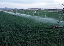
Center pivot
[edit]Center pivot irrigation is a form of sprinkler irrigation utilising several segments of pipe (usually galvanized steel or aluminium) joined and supported by trusses, mounted on wheeled towers with sprinklers positioned along its length. The system moves in a circular pattern and is fed with water from the pivot point at the center of the arc. These systems are found and used in all parts of the world and allow irrigation of all types of terrain. Newer systems have drop sprinkler heads.[28]
As of 2017[update] most center pivot systems have drops hanging from a U-shaped pipe attached at the top of the pipe with sprinkler heads that are positioned a few feet (at most) above the crop, thus limiting evaporative losses. Drops can also be used with drag hoses or bubblers that deposit the water directly on the ground between crops. Crops are often planted in a circle to conform to the center pivot. This type of system is known as LEPA (Low Energy Precision Application). Originally, most center pivots were water-powered. These were replaced by hydraulic systems (T-L Irrigation) and electric-motor-driven systems (Reinke, Valley, Zimmatic). Many modern pivots feature GPS devices.[29]
-
 A small center pivot system from beginning to end
 -
 Rotator style pivot applicator sprinkler
 -
 Center pivot with drop sprinklers
 -
 Wheel line irrigation system in Idaho, US, 2001
 -


Irrigation by lateral move (side roll, wheel line, wheelmove)
[edit]A series of pipes, each with a wheel of about 1.5 m diameter permanently affixed to its midpoint, and sprinklers along its length, are coupled together. Water is supplied at one end using a large hose. After sufficient irrigation has been applied to one strip of the field, the hose is removed, the water drained from the system, and the assembly rolled either by hand or with a purpose-built mechanism, so that the sprinklers are moved to a different position across the field. The hose is reconnected. The process is repeated in a pattern until the whole field has been irrigated.[30][31]
This system is less expensive to install than a center pivot, but much more labor-intensive to operate – it does not travel automatically across the field: it applies water in a stationary strip, must be drained, and then rolled to a new strip. Most systems use 100 or 130 mm (3.9 or 5.1 in) diameter aluminum pipe. The pipe doubles both as water transport and as an axle for rotating all the wheels. A drive system (often found near the centre of the wheel line) rotates the clamped-together pipe sections as a single axle, rolling the whole wheel line. Manual adjustment of individual wheel positions may be necessary if the system becomes misaligned.[30][31]
Wheel line systems are limited in the amount of water they can carry, and limited in the height of crops that can be irrigated. One useful feature of a lateral move system is that it consists of sections that can be easily disconnected, adapting to field shape as the line is moved. They are most often used for small, rectilinear, or oddly-shaped fields, hilly or mountainous regions, or in regions where labor is inexpensive.[30][31]
Subirrigation
[edit]Subirrigation has been used for many years in field crops in areas with high water tables. It is a method of artificially raising the water table to allow the soil to be moistened from below the plants' root zone. Often those systems are located on permanent grasslands in lowlands or river valleys and combined with drainage infrastructure. A system of pumping stations, canals, weirs and gates allows it to increase or decrease the water level in a network of ditches and thereby control the water table.
Subirrigation is also used in the commercial greenhouse production, usually for potted plants. Water is delivered from below, absorbed by upwards, and the excess collected for recycling. Typically, a solution of water and nutrients floods a container or flows through a trough for a short period, 10–20 minutes, and is then pumped back into a holding tank for reuse. Sub-irrigation in greenhouses requires fairly sophisticated, expensive equipment and management. Advantages are water and nutrient conservation, and labor savings through reduced system maintenance and automation. It is similar in principle and action to subsurface basin irrigation.
Another type of subirrigation is the self-watering container, also known as a sub-irrigated planter. This consists of a planter suspended over a reservoir with some type of wicking material, such as a polyester rope. The water is drawn up the wick through capillary action.[32][33] A similar technique is the wicking bed; this too uses capillary action.
Efficiency
[edit]Modern irrigation methods are efficient enough to supply the entire field uniformly with water, so that each plant has the amount of water it needs, neither too much nor too little.[34] Water use efficiency in the field can be determined as follows:
- Field Water Efficiency (%) = (Water Transpired by Crop ÷ Water Applied to Field) x 100
Increased irrigation efficiency has a number of positive outcomes for the farmer, the community and the wider environment. Low application efficiency infers that the amount of water applied to the field is in excess of the crop or field requirements. Increasing the application efficiency means that the amount of crop produced per unit of water increases. Improved efficiency may be achieved by applying less water to an existing field or by using water more wisely, thereby achieving higher yields in the same area of land. In some parts of the world, farmers are charged for irrigation water, hence over-application has a direct financial cost to the farmer. Irrigation often requires pumping energy (either electricity or fossil fuel) to deliver water to the field or supply the correct operating pressure. Hence, increased efficiency will reduce both the water cost and energy cost per unit of agricultural production. A reduction of water use on one field may mean that the farmer is able to irrigate a larger area of land, increasing total agricultural production. Low efficiency usually means that excess water is lost through seepage or runoff, both of which can result in loss of crop nutrients or pesticides with potential adverse impacts on the surrounding environment.
Improving the efficiency of irrigation is usually achieved in one of two ways: either by improving the system design or by optimizing the irrigation management. Improving system design includes conversion from one form of irrigation to another (e.g. from furrow to drip irrigation) and also through small changes in the current system (for example, changing flow rates and operating pressures). Irrigation management refers to the scheduling of irrigation events and decisions around how much water is applied.
Challenges
[edit]Environmental impacts
[edit]
Negative impacts frequently accompany extensive irrigation.[36] Some projects which diverted surface water for irrigation dried up the water sources, which led to a more extreme regional climate.[37] Projects that relied on groundwater and pumped too much from underground aquifers created subsidence and salinization. Salinization of irrigation water in turn damaged the crops and seeped into drinking water.[37] Pests and pathogens also thrived in the irrigation canals or ponds full of still water, which created regional outbreaks of diseases like malaria and schistosomiasis.[38][39][40] Governments also used irrigation schemes to encourage migration, especially of more desirable populations into an area.[41][42][43] Additionally, some of these large nationwide schemes failed to pay off at all, costing more than any benefit gained from increased crop yields.[44][45]
Overdrafting (depletion) of underground aquifers: In the mid-20th century, the advent of diesel and electric motors led to systems that could pump groundwater out of major aquifers faster than drainage basins could refill them. This can lead to permanent loss of aquifer capacity, decreased water quality, ground subsidence, and other problems. The future of food production in such areas as the North China Plain, the Punjab region in India and Pakistan, and the Great Plains of the US is threatened by this phenomenon.[46][47]
Technical challenges
[edit]
Irrigation schemes involve solving numerous engineering and economic problems while minimizing negative environmental consequences.[36] Such problems include:
- Ground subsidence (e.g. New Orleans, Louisiana)
- Underirrigation or irrigation giving only just enough water for the plant (e.g. in drip line irrigation) gives poor soil salinity control, which leads to increased soil salinity with consequent buildup of toxic salts on soil surface in areas with high evaporation. This requires either leaching to remove these salts and a method of drainage to carry the salts away. When using drip lines, the leaching is best done regularly at certain intervals (with only a slight excess of water), so that the salt is flushed back under the plant's roots.[48]
- Overirrigation because of poor distribution uniformity or management wastes water, chemicals, and may lead to water pollution.[49]
- Deep drainage (from over-irrigation) may result in rising water tables which in some instances will lead to problems of irrigation salinity requiring watertable control by some form of subsurface land drainage.[50][51] For example, in Australia, over-abstraction of fresh water for intensive irrigation activities has caused 33% of the land area to be at risk of salination.[52]
- Drainage front instability, also known as viscous fingering, where an unstable drainage front results in a pattern of fingers and viscous entrapped saturated zones.
- Irrigation with saline or high-sodium water may damage soil structure owing to the formation of alkaline soil.
- Clogging of filters: algae can clog filters, drip installations, and nozzles. Chlorination, algaecide, UV and ultrasonic methods can be used for algae control in irrigation systems.
- Complications in accurately measuring irrigation performance which changes over time and space using measures such as productivity, efficiency, equity and adequacy.[53]
- Macro-irrigation, typical in intensive agriculture, where also are used agrochemicals, often causes eutrophication.
Social aspects
[edit]- Competition for surface water rights[54]
- Assisting smallholders in sustainably and collectively managing irrigation technology and changes in technology.[55]
History
[edit]Ancient history
[edit]
Archaeological investigation has found evidence of irrigation in areas lacking sufficient natural rainfall to support crops for rainfed agriculture. Some of the earliest known use of the technology dates to the 6th millennium BCE in Khuzistan in the south-west of Iran.[56][57] The site of Choga Mami, in present-day Iraq on the border with Iran, is believed to be the earliest to show the first canal irrigation in operation at about 6000 BCE.[58]
Irrigation was used as a means of manipulating water in the alluvial plains of the Indus valley civilization, the application of which is estimated to have begun around 4500 BCE and drastically increased the size and prosperity of their agricultural settlements.[59] The Indus Valley Civilization developed sophisticated irrigation and water-storage systems, including artificial reservoirs at Girnar dated to 3000 BCE, and an early canal irrigation system from c. 2600 BCE. Large-scale agriculture was practiced, with an extensive network of canals used for the purpose of irrigation.[59][60]
Farmers in the Mesopotamian plain used irrigation from at least the third-millennium BCE.[61] They developed perennial irrigation, regularly watering crops throughout the growing season by coaxing water through a matrix of small channels formed in the field.[62] Ancient Egyptians practiced basin irrigation using the flooding of the Nile to inundate land plots which had been surrounded by dikes. The flood water remained until the fertile sediment had settled before the engineers returned the surplus to the watercourse.[63] There is evidence of the ancient Egyptian pharaoh Amenemhet III in the twelfth dynasty (about 1800 BCE) using the natural lake of the Faiyum Oasis as a reservoir to store surpluses of water for use during dry seasons. The lake swelled annually from the flooding of the Nile.[64]

The Ancient Nubians developed a form of irrigation by using a waterwheel-like device called a sakia. Irrigation began in Nubia between the third and second millennia BCE.[65] It largely depended upon the flood waters that would flow through the Nile River and other rivers in what is now the Sudan.[66]
In sub-Saharan Africa, irrigation reached the Niger River region cultures and civilizations by the first or second millennium BCE and was based on wet-season flooding and water harvesting.[67][68]
Evidence of terrace irrigation occurs in pre-Columbian America, early Syria, India, and China.[63] In the Zana Valley of the Andes Mountains in Peru, archaeologists have found remains of three irrigation canals radiocarbon-dated from the 4th millennium BCE, the 3rd millennium BCE and the 9th century CE. These canals provide the earliest record of irrigation in the New World. Traces of a canal possibly dating from the 5th millennium BCE were found under the 4th-millennium canal.[69]
Ancient Persia (modern-day Iran) used irrigation as far back as the 6th millennium BCE to grow barley in areas with insufficient natural rainfall.[70][56] The Qanats, developed in ancient Persia about 800 BCE, are among the oldest known irrigation methods still in use today. They are now found in Asia, the Middle East, and North Africa. The system comprises a network of vertical wells and gently sloping tunnels driven into the sides of cliffs and steep hills to tap groundwater.[71] The noria, a water wheel with clay pots around the rim powered by the flow of the stream (or by animals where the water source was still), first came into use at about this time among Roman settlers in North Africa. By 150 BCE, the pots were fitted with valves to allow smoother filling as they were forced into the water.[72]
Sri Lanka
[edit]The irrigation works of ancient Sri Lanka, the earliest dating from about 300 BCE in the reign of King Pandukabhaya, and under continuous development for the next thousand years, were one of the most complex irrigation systems of the ancient world. They included underground canals and artificial reservoirs to store water. These reservoirs and canal systems were used primarily to irrigate paddy fields, which require a lot of water to cultivate. Most of these irrigation systems still exist undamaged up to now, in Anuradhapura and Polonnaruwa, because of the advanced and precise engineering. The system was extensively restored and further extended during the reign of King Parakrama Bahu (1153–1186 CE).[73]
China
[edit]
The oldest known hydraulic engineers of China were Sunshu Ao (6th century BCE) of the Spring and Autumn period and Ximen Bao (5th century BCE) of the Warring States period, both of whom worked on large irrigation projects. In the Sichuan region belonging to the state of Qin of ancient China, the Dujiangyan Irrigation System devised by the Qin Chinese hydrologist and irrigation engineer Li Bing was built in 256 BCE to irrigate a vast area of farmland that today still supplies water.[74] By the 2nd century CE, during the Han dynasty, the Chinese also used chain pumps which lifted water from a lower elevation to a higher one.[75] These were powered by manual foot-pedal, hydraulic waterwheels, or rotating mechanical wheels pulled by oxen.[76] The water was used for public works, providing water for urban residential quarters and palace gardens, but mostly for irrigation of farmland canals and channels in the fields.[77]
Korea
[edit]Korea, Chang Yŏngsil, also known as Jang Yeong-sil, a Korean engineer of the Joseon dynasty, under the active direction of the king, Sejong the Great, invented the world's first rain gauge, uryanggye (Korean: 우량계) in 1441. It was installed in irrigation tanks as part of a nationwide system to measure and collect rainfall for agricultural applications. Planners and farmers could better use the information gathered in the[which?] survey with this instrument.[78]
North America
[edit]
The earliest agricultural irrigation canal system known in the area of the present-day United States dates to between 1200 BCE and 800 BCE and was discovered by Desert Archaeology, Inc. in Marana, Arizona (adjacent to Tucson) in 2009.[79] The irrigation-canal system predates the Hohokam culture by two thousand years and belongs to an unidentified culture. In North America, the Hohokam were the only culture known to rely on irrigation canals to water their crops, and their irrigation systems supported the largest population in the Southwest by CE 1300. The Hohokam constructed various simple canals combined with weirs in their various agricultural pursuits. Between the 7th and 14th centuries, they built and maintained extensive irrigation networks along the lower Salt and middle Gila Rivers that rivaled the complexity of those used in the ancient Near East, Egypt, and China. These were constructed using relatively simple excavation tools, without the benefit of advanced engineering technologies, and achieved drops of a few feet per mile, balancing erosion and siltation. The Hohokam cultivated cotton, tobacco, maize, beans, and squash varieties and harvested an assortment of wild plants. Late in the Hohokam Chronological Sequence, they used extensive dry-farming systems, primarily to grow agave for food and fiber. Their reliance on agricultural strategies based on canal irrigation, vital in their less-than-hospitable desert environment and arid climate, provided the basis for the aggregation of rural populations into stable urban centers.[80]
South America
[edit]The oldest known irrigation canals in the Americas are in the desert of northern Peru in the Zaña Valley near the hamlet of Nanchoc. The canals have been radiocarbon dated to at least 3400 BCE and possibly as old as 4700 BCE. The canals at that time irrigated crops such as peanuts, squash, manioc, chenopods, a relative of Quinoa, and later maize.[69]
Modern history
[edit]The scale of global irrigation increased dramatically over the 20th century. In 1800, 8 million hectares were irrigated; in 1950, 94 million hectares, and in 1990, 235 million hectares. By 1990, 30% of the global food production came from irrigated land.[6] Irrigation techniques across the globe included canals redirecting surface water,[7][8] groundwater pumping, and diverting water from dams. National governments led most irrigation schemes within their borders, but private investors[9] and other nations,[8] especially the United States,[10] China,[11] and European countries like the United Kingdom,[12] funded and organized some schemes within other nations. Irrigation enabled the production of more crops, especially commodity crops in areas that otherwise could not support them. Countries frequently invested in irrigation to increase wheat, rice, or cotton production, often with the overarching goal of increasing self-sufficiency.[12] In the 20th century, global anxiety, specifically about the American cotton monopoly, fueled many empirical irrigation projects: Britain began developing irrigation in India, the Ottomans in Egypt, the French in Algeria, the Portuguese in Angola, the Germans in Togo, and Soviets in Central Asia.[8]
Negative impacts frequently accompany extensive irrigation. Some projects that diverted surface water for irrigation dried up the water sources, which led to a more extreme regional climate.[37] Projects that relied on groundwater and pumped too much from underground aquifers created subsidence and salinization. Salinization of irrigation water damaged the crops and seeped into drinking water.[37] Pests and pathogens also thrived in the irrigation canals or ponds full of still water, which created regional outbreaks of diseases like malaria and schistosomiasis.[38][39][40] Governments also used irrigation schemes to encourage migration, especially of more desirable populations into an area.[41][42][43] Additionally, some of these large nationwide schemes failed to pay off at all, costing more than any benefit gained from increased crop yields.[44][45]
American West
[edit]Irrigated land in the United States increased from 300,000 acres in 1880 to 4.1 million in 1890 to 7.3 million in 1900.[45] Two thirds of this irrigation sources from groundwater or small ponds and reservoirs, while the other one third comes from large dams.[81] One of the main attractions of irrigation in the West was its increased dependability compared to rainfall-watered agriculture in the East. Proponents argued that farmers with a dependable water supply could more easily get loans from bankers interested in this more predictable farming model.[82] Most irrigation in the Great Plains region derived from underground aquifers. Euro-American farmers who colonized the region in the 19th century tried to grow the commodity crops that they were used to, like wheat, corn, and alfalfa, but rainfall stifled their growing capacity. Between the late 1800s and the 1930s, farmers used wind-powered pumps to draw groundwater. These windpumps had limited power, but the development of gas-powered pumps in the mid-1930s pushed wells deep into the Ogallala Aquifer. Farmers irrigated fields by laying pipes across the field with sprinklers at intervals, a labor-intensive process, until the advent of the center-pivot sprinkler after World War II, which made irrigation significantly easier.[83] By the 1970s farmers drained the aquifer ten times faster than it could recharge, and by 1993 they had removed half of the accessible water.[84]
Large-scale federal funding and intervention pushed through the majority of irrigation projects in the West, especially in California, Colorado, Arizona, and Nevada. At first, plans to increase irrigated farmland, largely by giving land to farmers and asking them to find water, failed across the board. Congress passed the Desert Land Act in 1877 and the Carey Act in 1894, which only marginally increased irrigation.[85] Only in 1902 did Congress pass the National Reclamation Act, which channeled money from the sale of western public lands, in parcels up to 160 acres large, into irrigation projects on public or private land in the arid West.[86] The Congressmen who passed the law and their wealthy supporters supported Western irrigation because it would increase American exports, 'reclaim' the West, and push the Eastern poor out West for a better life.[87]
While the National Reclamation Act was the most successful piece of federal irrigation legislation, the implementation of the act did not go as planned. The Reclamation Service chose to push most of the Act's money toward construction rather than settlement, so the Service overwhelmingly prioritized building large dams like the Hoover Dam.[88] Over the 20th century, Congress and state governments grew more frustrated with the Reclamation Service and the irrigation schemes. Frederick Newell, head of the Reclamation Service, proving uncompromising and challenging to work with, falling crop prices, resistance to delay debt payments, and refusal to begin new projects until the completion of old ones all contributed.[89] The Reclamation Extension Act of 1914, transferring a significant amount of irrigation decision-making power regarding irrigation projects from the Reclamation Service to Congress, was in many ways a result of increasing political unpopularity of the Reclamation Service.[90]
In the lower Colorado Basin of Arizona, Colorado, and Nevada, the states derive irrigation water largely from rivers, especially the Colorado River, which irrigates more than 4.5 million acres of land, with a less significant amount coming from groundwater.[91] In the 1952 case Arizona v. California, Arizona sued California for increased access to the Colorado River, under the grounds that their groundwater supply could not sustain their almost entirely irrigation-based agricultural economy, which they won.[92] California, which began irrigating in earnest in the 1870s in San Joaquin Valley,[93] had passed the Wright Act of 1887 permitting agricultural communities to construct and operate needed irrigation works.[94] The Colorado River also irrigates large fields in California's Imperial Valley, fed by the National Reclamation Act-built All-American Canal.[95][96]
Soviet Central Asia
[edit]When the Bolsheviks conquered Central Asia in 1917, the native Kazakhs, Uzbeks, and Turkmens used minimal irrigation. The Slavic immigrants pushed into the area by the Tsarist government[97] brought their irrigation methods, including waterwheels, the use of rice paddies to restore salted land, and underground irrigation channels. Russians dismissed these techniques as crude and inefficient. Despite this, tsarist officials maintained these systems through the late 19th century without other solutions.[98]
Before conquering the area, the Russian government accepted a 1911 American proposal to send hydraulic experts to Central Asia to investigate the potential for large-scale irrigation. A 1918 decree by Lenin then encouraged irrigation development in the region, which began in the 1930s. When it did, Stalin and other Soviet leaders prioritized large-scale, ambitious hydraulic projects, especially along the Volga River. The Soviet irrigation push stemmed mainly from their late 19th century fears of the American cotton monopoly and subsequent desire to achieve cotton self-sufficiency.[99] They had built up their textile manufacturing industry in the 19th century, requiring increased cotton and irrigation, as the region did not receive enough rainfall to support cotton farming.[98]
The Russians built dams on the Don and Kuban Rivers for irrigation, removing freshwater flow from the Sea of Azov and making it much saltier. Depletion and salinization scourged other areas of the Russian irrigation project. In the 1950s, Soviet officials began also diverting the Syr Darya and the Amu Darya, which fed the Aral Sea. Before diversion, the rivers delivered 55 cubic kilometres (13 cu mi) of water to the Aral Sea per year, but after, they only delivered 6 cubic kilometres (1.4 cu mi). Because of its reduced inflow, the Aral Sea covered less than half of its original seabed, which made the regional climate more extreme and created airborne salinization, lowering nearby crop yields.[100]
By 1975, the USSR used eight times as much water as they had in 1913, mostly for irrigation. Russia's expansion of irrigation began to decrease in the late 1980s, and irrigated hectares in Central Asia capped out at 7 million. Mikhail Gorbachev killed a proposed plan to reverse the Ob and Yenisei for irrigation in 1986, and the breakup of the USSR in 1991 ended Russian investment in Central Asian cotton irrigation.[101]
Africa
[edit]Different irrigation schemes with various goals and success rates have been implemented across Africa in the 20th century but have all been influenced by colonial forces. The Tana River Irrigation Scheme in eastern Kenya, completed between 1948 and 1963, opened up new lands for agriculture. The Kenyan government attempted to resettle the area with detainees from the Mau Mau uprising.[102] Italian oil drillers discovered Libya's underground water resources during the Italian colonization of Libya. This water lay dormant until 1969, when Muammar al-Gaddafi and American Armand Hammer built the Great Man-Made River to deliver the Saharan water to the coast. The water largely contributed to irrigation but cost four to ten times more than the crops it produced were worth.[103]
In 1912, the Union of South Africa created an irrigation department and began investing in water storage infrastructure and irrigation. The government used irrigation and dam-building to further social goals like poverty relief by creating construction jobs for poor whites and irrigation schemes to increase white farming. One of their first significant irrigation projects was the Hartbeespoort Dam, begun in 1916 to elevate the living conditions of the 'poor whites' in the region and eventually completed as a 'whites only' employment opportunity.[104] The Pretoria irrigation scheme, Kammanassie project, and Buchuberg irrigation scheme on the Orange River all followed in the same vein in the 1920s and 30s.[42]
In Egypt, modern irrigation began with Muhammad Ali Pasha in the mid-1800s, who sought to achieve Egyptian independence from the Ottomans through increased trade with Europe—specifically cotton exportation.[105] His administration proposed replacing the traditional Nile basin irrigation, which took advantage of the annual ebb and flow of the Nile, with irrigation barrages in the lower Nile, which better suited cotton production. Egypt devoted 105,000 ha to cotton in 1861, which increased fivefold by 1865. Most of their exports were shipped to England, and the United States Civil War-induced cotton scarcity in the 1860s cemented Egypt as England's cotton producer.[106] As the Egyptian economy became more dependent on cotton in the 20th century, controlling even small Nile floods became more important. Cotton production was more at risk of destruction than more common crops like barley or wheat.[107] After the British occupation of Egypt in 1882, the British intensified the conversion to perennial irrigation with the construction of the Delta Barrage, the Assiut Barrage, and the first Aswan Dam. Perennial irrigation decreased local control over water and made traditional subsistence farming or the farming of other crops incredibly difficult, eventually contributing to widespread peasant bankruptcy and the 1879-1882 'Urabi revolt.[108]
Examples by country
[edit]See the below template:
(Link to a similar template for mobile users.)
Gallery
[edit]-
 The hub of a center-pivot irrigation system
 -
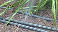 Leaks in micro-irrigation drip lines
 -
 Sprinkler irrigation of blueberries in Plainville, New York, United States
 -
 Irrigation in Tamil Nadu, India
 -
 Irrigation ditch in Montour County, Pennsylvania, USA
 -
 Water gardens in Sigiriya, Sri Lanka
 -
 Micro-sprinkler


See also
[edit]References
[edit]- ^ Snyder, R. L.; Melo-Abreu, J. P. (2005). Frost protection: fundamentals, practice, and economics. Vol. 1. Food and Agriculture Organization of the United Nations. ISBN 978-92-5-105328-7. ISSN 1684-8241.
- ^ Siebert, S.; J. Hoogeveen; P. Döll; J-M. Faurès; S. Feick; K. Frenken (November 10, 2006). "The Digital Global Map of Irrigation Areas – Development and Validation of Map Version 4" (PDF). Tropentag 2006 – Conference on International Agricultural Research for Development. Bonn, Germany. Retrieved March 14, 2007.
- ^ The World. The World Factbook. Central Intelligence Agency.
- ^ "On Water". European Investment Bank. Retrieved December 7, 2020.
- ^ "Water in Agriculture". World Bank. Retrieved December 7, 2020.
- ^ a b McNeill 2000 pp.180–181.
- ^ a b McNeill 2000 pp.174.
- ^ a b c d e Peterson 2016
- ^ a b McNeill 2000 pp.153.
- ^ a b Ekbladh 2002 pp.337.
- ^ a b Bosshard 2009.
- ^ a b c d McNeill 2000 pp.169-170.
- ^ World Food and Agriculture – Statistical Yearbook 2023 | FAO | Food and Agriculture Organization of the United Nations. 2023. doi:10.4060/cc8166en. ISBN 978-92-5-138262-2. Retrieved December 13, 2023 – via FAODocuments.
- ^ Natural Resource Management and Environmental Dept. "Crops Need Water". Archived from the original on 16 January 2012. Retrieved 17 March 2012.
- ^ a b Otoo, Miriam; Drechsel, Pay (2018). Resource recovery from waste: business models for energy, nutrient and water reuse in low- and middle-income countries. Oxon, UK: Routledge - Earthscan.
- ^ a b WHO (2006). WHO Guidelines for the Safe Use of Wastewater, Excreta and Greywater – Volume IV: Excreta and greywater use in agriculture. World Health Organization (WHO), Geneva, Switzerland
- ^ Garcia-Garcia, Guillermo; Jagtap, Sandeep (January 2021). "Enhancement of a Spent Irrigation Water Recycling Process: A Case Study in a Food Business". Applied Sciences. 11 (21) 10355. doi:10.3390/app112110355.
- ^ "ISO 16075-1:2015 – Guidelines for treated wastewater use for irrigation projects – Part 1: The basis of a reuse project for irrigation". ISO. March 21, 2018.
- ^ Ofori, Solomon; Puškáčová, Adéla; Růžičková, Iveta; Wanner, Jiří (March 2021). "Treated wastewater reuse for irrigation: Pros and cons". Science of the Total Environment. 760 144026. Bibcode:2021ScTEn.76044026O. doi:10.1016/j.scitotenv.2020.144026. PMID 33341618.
- ^ Moreira da Silva, Manuela; Resende, Flávia C.; Freitas, Bárbara; Aníbal, Jaime; Martins, António; Duarte, Amílcar (January 2022). "Urban Wastewater Reuse for Citrus Irrigation in Algarve, Portugal—Environmental Benefits and Carbon Fluxes". Sustainability. 14 (17) 10715. Bibcode:2022Sust...1410715M. doi:10.3390/su141710715. hdl:10400.1/18203.
- ^ McDill, Stuart (November 27, 2019). "Startup helps Scottish farmers grow gourmet plants with sea water". Reuters. Thomson Reuters. Retrieved December 2, 2019.
Seawater Solutions is helping farmers on Scotland's west coast adapt to the reality of less rain by choosing salt-resistant plants and developing saltmarshes - land flooded by tidal waters - for them to grow in.
- ^ O'Toole, Emer (July 29, 2019). "Seawater Solutions is tacking agriculture's impact on climate change". The National. Newsquest Media Group Ltd. Retrieved December 2, 2019.
A system of farming that creates wetland ecosystems on which food can be grown, while carbon is captured at a rate of up to 40 times higher than the same area of rainforest, and profits are more than eight times more profitable than the average potato field.
- ^ Chartres, C. and Varma, S. Out of water. From Abundance to Scarcity and How to Solve the World's Water Problems FT Press (USA), 2010
- ^ "Flood Irrigation Service". City of Tempe, Arizona. Retrieved July 29, 2017.
- ^ Frenken, K. (2005). "Irrigation in Africa in figures – AQUASTAT Survey – 2005". Water Report 29 (PDF). Food and Agriculture Organization of the United Nations. ISBN 978-92-5-105414-7. Archived from the original (PDF) on July 6, 2017. Retrieved March 14, 2007.
- ^ Provenzano, Giuseppe (2007). "Using HYDRUS-2D Simulation Model to Evaluate Wetted Soil Volume in Subsurface Drip Irrigation Systems". Journal of Irrigation and Drainage Engineering. 133 (4): 342–350. Bibcode:2007JIDE..133..342P. doi:10.1061/(ASCE)0733-9437(2007)133:4(342).
- ^ "Drip Irrigation System for sustainable agriculture". Agriculture land usa. Retrieved March 7, 2024.
- ^ Mader, Shelli (May 25, 2010). "Center pivot irrigation evolutionizes agriculture". The Fence Post Magazine. Archived from the original on September 8, 2016. Retrieved June 6, 2012.
- ^ Gaines, Tharran (January 7, 2017). "GPS Swing Arms Prove Their Worth". Successful Farming. Retrieved February 1, 2018.
- ^ a b c Peters, Troy. "Managing Wheel - Lines and Hand - Lines for High Profitability" (PDF). Archived from the original (PDF) on October 21, 2016. Retrieved May 29, 2015.
- ^ a b c Hill, Robert. "Wheelmove Sprinkler Irrigation Operation and Management" (PDF). Archived (PDF) from the original on October 9, 2022. Retrieved May 29, 2015.
- ^ "Polyester ropes natural irrigation technique". Entheogen.com. Archived from the original on April 12, 2012. Retrieved June 19, 2012.
- ^ "DIY instructions for making self-watering system using ropes". Instructables.com. March 17, 2008. Retrieved June 19, 2012.
- ^ "Water use efficiency - agriwaterpedia.info".
- ^ Liu, Pang-Wei; Famiglietti, James S.; Purdy, Adam J.; Adams, Kyra H.; et al. (December 19, 2022). "Groundwater depletion in California's Central Valley accelerates during megadrought". Nature Communications. 13 (7825): 7825. Bibcode:2022NatCo..13.7825L. doi:10.1038/s41467-022-35582-x. PMC 9763392. PMID 36535940. (Archive of chart itself)
- ^ a b ILRI, 1989, Effectiveness and Social/Environmental Impacts of Irrigation Projects: a Review. In: Annual Report 1988, International Institute for Land Reclamation and Improvement (ILRI), Wageningen, The Netherlands, pp. 18 – 34. On line: [1]
- ^ a b c d McNeill 2000 pp.164-165.
- ^ a b McNeill 2019.
- ^ a b Worster 1992 pp.112-13.
- ^ a b McNeill 2000 pp.171.
- ^ a b Parker 2020
- ^ a b c Visser 2018
- ^ a b Worster 1992 pp.156-57.
- ^ a b Pisani 2002 p.5.
- ^ a b c McNeill 2000
- ^ "A new report says we're draining our aquifers faster than ever". High Country News. June 22, 2013. Retrieved February 11, 2014.
- ^ "Management of aquifer recharge and discharge processes and aquifer storage equilibrium" (PDF). Archived from the original (PDF) on September 21, 2018. Retrieved February 11, 2014.
- ^ EOS magazine, September 2009
- ^ Hukkinen, Janne, Emery Roe, and Gene I. Rochlin. "A salt on the land: A narrative analysis of the controversy over irrigation-related salinity and toxicity in California's San Joaquin Valley." Policy Sciences 23.4 (1990): 307–329. online Archived 2015-01-02 at the Wayback Machine
- ^ Drainage Manual: A Guide to Integrating Plant, Soil, and Water Relationships for Drainage of Irrigated Lands. Interior Dept., Bureau of Reclamation. 1993. ISBN 978-0-16-061623-5.
- ^ "Free articles and software on drainage of waterlogged land and soil salinity control in irrigated land". Retrieved July 28, 2010.
- ^ Gordon L., D. M. (2003). "Land cover change and water vapour flows: learning from Australia". Philosophical Transactions of the Royal Society B: Biological Sciences. 358 (1440): 1973–1984. doi:10.1098/rstb.2003.1381. JSTOR 3558315. PMC 1693281. PMID 14728792.
- ^ Lankford, Bruce; Closas, Alvar; Dalton, James; López Gunn, Elena; Hess, Tim; Knox, Jerry W.; Van Der Kooij, Saskia; Lautze, Jonathan; Molden, David; Orr, Stuart; Pittock, Jamie; Richter, Brian; Riddell, Philip J.; Scott, Christopher A.; Venot, Jean-Philippe; Vos, Jeroen; Zwarteveen, Margreet (November 1, 2020). "A scale-based framework to understand the promises, pitfalls and paradoxes of irrigation efficiency to meet major water challenges". Global Environmental Change. 65 102182. Bibcode:2020GEC....6502182L. doi:10.1016/j.gloenvcha.2020.102182. hdl:1885/224453. ISSN 0959-3780.
- ^ Rosegrant, Mark W., and Hans P. Binswanger. "Markets in tradable water rights: potential for efficiency gains in developing country water resource allocation." World development (1994) 22#11 pp: 1613–1625.
- ^ Venot, Jean-Philippe (July 6, 2017). Venot, Jean-Philippe; Kuper, Marcel; Zwarteveen, Margreet (eds.). Drip Irrigation for Agriculture. doi:10.4324/9781315537146. ISBN 978-1-315-53714-6.
- ^ a b Flannery, Kent V. (1969). "Origins and ecological effects of early domestication in Iran and the Near East". In Ucko, Peter John; Dimbleby, G. W. (eds.). The Domestication and Exploitation of Plants and Animals. New Brunswick, New Jersey: Transaction Publishers (published 2007). p. 89. ISBN 978-0-202-36557-2. Retrieved January 12, 2019.
- ^ Lawton, H. W.; Wilke, P. J. (1979). "Ancient Agricultural Systems in Dry Regions of the Old World". In Hall, A. E.; Cannell, G. H.; Lawton, H.W. (eds.). Agriculture in Semi-Arid Environments. Ecological Studies. Vol. 34 (reprint ed.). Berlin: Springer Science & Business Media (published 2012). p. 13. ISBN 978-3-642-67328-3. Retrieved January 12, 2019.
- ^ Alexander R. Thomas, Gregory M. Fulkerson (2021), City and Country: The Historical Evolution of Urban-Rural Systems. Rowman & Littlefield. p.137
- ^ a b Rodda, J. C.; Ubertini, Lucio, eds. (2004). The Basis of Civilization--water Science?. International Association of Hydrological Science. ISBN 978-1-901502-57-2.
- ^ "Ancient India Indus Valley Civilization". Minnesota State University "e-museum". Archived from the original on February 5, 2007. Retrieved January 10, 2007.
- ^ Crawford, Harriet, ed. (2013). The Sumerian World. Routledge Worlds. Abingdon, Oxfordshire: Routledge. ISBN 978-1-136-21911-5. Retrieved January 12, 2019.
- ^ Hill, Donald (1984). "2: Irrigation and Water supply". A History of Engineering in Classical and Medieval Times (reprint ed.). London: Routledge (published 2013). p. 18. ISBN 978-1-317-76157-0. Retrieved January 12, 2019.
- ^ a b p19 Hill, A History of Engineering in Classical and Medieval Times
- ^ "Amenemhet III". Britannica Concise. Archived from the original on May 10, 2007. Retrieved January 10, 2007.
- ^ G. Mokhtar (January 1, 1981). Ancient civilizations of Africa. Unesco. International Scientific Committee for the Drafting of a General History of Africa. p. 309. ISBN 978-0-435-94805-4. Retrieved June 19, 2012 – via Books.google.com.
- ^ Bulliet, Richard; Crossley, Pamela Kyle; Headrick, Daniel; Hirsch, Steven (June 18, 2008). The Earth and Its Peoples, Volume I: A Global History, to 1550. Wadsworth. pp. 53–56. ISBN 978-0-618-99238-6.
- ^ "Traditional technologies". Fao.org. Retrieved June 19, 2012.
- ^ "Africa, Emerging Civilizations In Sub-Sahara Africa. Various Authors; Edited By: R. A. Guisepi". History-world.org. Archived from the original on June 12, 2010. Retrieved June 19, 2012.
- ^ a b Dillehay, Tom D.; Eling, Herbert H. Jr.; Rossen, Jack (2005). "Preceramic irrigation canals in the Peruvian Andes" (PDF). Proceedings of the National Academy of Sciences of the United States of America. 102 (47). National Academy of Science: 17241–17244. Bibcode:2005PNAS..10217241D. doi:10.1073/pnas.0508583102. PMC 1288011. PMID 16284247. Archived (PDF) from the original on October 9, 2022. Retrieved November 20, 2020.
- ^ The History of Technology – Irrigation. Encyclopædia Britannica, 1994 edition.
- ^ "Qanat Irrigation Systems and Homegardens (Iran)". Globally Important Agriculture Heritage Systems. UN Food and Agriculture Organization. Archived from the original on June 24, 2008. Retrieved January 10, 2007.
- ^ Encyclopædia Britannica, 1911 and 1989 editions
- ^ de Silva, Sena (1998). "Reservoirs of Sri Lanka and their fisheries". UN Food and Agriculture Organization. Retrieved January 10, 2007.
- ^ China – history. Encyclopædia Britannica, 1994 edition.
- ^ Needham, Joseph (1986). Science and Civilization in China: Volume 4, Physics and Physical Technology, Part 2, Mechanical Engineering. Taipei: Caves Books Ltd. Pages 344–346.
- ^ Needham, Volume 4, Part 2, 340–343.
- ^ Needham, Volume 4, Part 2, 33, 110.
- ^ Baek Seok-gi 백석기 (1987). Jang Yeong-sil 장영실. Woongjin Wiin Jeon-gi 웅진위인전기 11. Woongjin Publishing Co., Ltd.
- ^ "Earliest Canals in America – Archaeology Magazine Archive".
- ^ James M. Bayman, "The Hohokam of Southwest North America." Journal of World Prehistory 15.3 (2001): 257–311.
- ^ McCully 2001 p. 166.
- ^ Worster 1992 pp.114-15.
- ^ How Center Pivot Irrigation Brought the Dust Bowl Back to Life, retrieved May 6, 2022
- ^ McNeill 2000 pp. 151-52
- ^ Worster 1992 pp.156-157.
- ^ Worster 1992 p. 161.
- ^ Worster 1992 pp.166-67.
- ^ Pisani 2002 p.30.
- ^ Pisani 2002 p.152.
- ^ Pisani 2002.
- ^ Colorado River Basin Studies, March 24, 2022, retrieved May 6, 2022
- ^ August JL (2007). Dividing western waters: Mark Wilmer and Arizona v. California. TCU Press.
- ^ Worster 1992 p. 102.
- ^ Worster 1992 p. 108.
- ^ McNeill 2000 p. 178
- ^ Worster 1992 p.208.
- ^ Morrison A, Slavic peasant settlers in Russian Turkestan, 1886-1917, retrieved May 6, 2022
- ^ a b Peterson 2016.
- ^ McNeill 2000 p. 163
- ^ McNeill 2000 pp. 164-5
- ^ McNeill 2000 p. 166
- ^ Parker 2020.
- ^ McNeill 2000 p. 155
- ^ Clynick T (2007). "A Search for Origins: Science, history and South Africa's "Cradle of Humankind"". In Esterhuysen A, Jenkins T, Bonner P (eds.). White South Africa's 'weak sons': Poor whites and the Hartbeespoort Dam. Wits University Press. pp. 248–274. ISBN 978-1-86814-669-7.
- ^ Ross 2017 p. 33.
- ^ Ross 2017 p. 32.
- ^ McNeill 2000 p. 167
- ^ Ross 2017 p. 37-38.
Sources
[edit]- Bosshard, Peter. "China Dams the World." World Policy Journal 26, no. 4 (2009): 43–51.
- Ekbladh, David. "'Mr. TVA': Grass-Roots Development, David Lilienthal, and the Rise and Fall of the Tennessee Valley Authority as a Symbol for U.S. Overseas Development, 1933-1973." Diplomatic History 29, no. 3 (Summer 2002): 335–74.
- Johnson, Matthew P. "Swampy Sugar Lands: Irrigation Dams and the Rise and Fall of Malaria in Puerto Rico, 1898–1962." Journal of Latin American Studies 51, no. 2 (May 2019): 243–71. https://doi.org/10.1017/S0022216X18000743.
- Lyster, Rosa. "Along the Water." London Review of Books, May 6, 2021. https://www.lrb.co.uk/the-paper/v43/n09/rosa-lyster/diary.
- McCully, Patrick. Silenced Rivers: The Ecology and Politics of Large Dams. Enlarged&Updated ed. London ; New York: Zed Books, 2001.
- McNeill, John Robert. Something New under the Sun: An Environmental History of the Twentieth-Century World. 1st ed. New York: W.W. Norton & Company, 2000.
- Parker, James. "A 'Juggernaut of Progress'? Irrigation and Statecraft in Late-Colonial Kenya." International Journal of African Historical Studies 53, no. 3 (September 2020): 335–59.
- Peterson, Maya. "US to USSR: American Experts, Irrigation, and Cotton in Soviet Central Asia, 1929–32." Environmental History 21, no. 3 (July 2016): 442–66. https://doi.org/10.1093/envhis/emw006.
- Ross, Corey. Ecology and Power in the Age of Empire: Europe and the Transformation of the Tropical World. First edition. Oxford: Oxford University Press, 2017.
- Pisani, Donald J. Water and American Government: The Reclamation Bureau, National Water Policy, and the West, 1902-1935. Berkeley: University of California Press, 2002.
- Visser, Wessel. "Water as Agent for Social Change, 1900–1939 : Two Case Studies of Developmental State Approaches in Establishing Irrigation Schemes." Historia 63, no. 2 (November 2018): 40–61. https://doi.org/10.17159/2309-8392/2018/v63n2a3.
- Worster, Donald. Rivers of Empire: Water, Aridity, and the Growth of the American West. New York ; Oxford, England: Oxford University Press, 1992.
Sources
[edit]![]() This article incorporates text from a free content work. Licensed under CC BY-SA IGO 3.0 (license statement/permission). Text taken from World Food and Agriculture – Statistical Yearbook 2023, FAO, FAO.
This article incorporates text from a free content work. Licensed under CC BY-SA IGO 3.0 (license statement/permission). Text taken from World Food and Agriculture – Statistical Yearbook 2023, FAO, FAO.
External links
[edit]- International Commission on Irrigation and Drainage (ICID)
- Irrigation at the Water Quality Information Center, U.S. Department of Agriculture
- AQUASTAT: FAO's global information system on water and agriculture
| Air |
| ||||||
|---|---|---|---|---|---|---|---|
| Energy | |||||||
| Land | |||||||
| Life | |||||||
| Water |
| ||||||
| Related |
| ||||||