
Community hub
Manila
View on Wikipedia
Manila,[a] officially the City of Manila,[b] is the capital and second-most populous city of the Philippines after Quezon City. According to the 2024 census, it has a population of 1,902,590 people.[11] Located on the eastern shore of Manila Bay on the island of Luzon, it is classified as a highly urbanized city. With 43,611.5 inhabitants per square kilometer (112,953/sq mi), Manila is one of the world's most densely populated cities proper.[6][7]
Key Information
.jpg)

.jpg)


![Map of Metro Manila with Manila highlighted[a]](https://en.wikipedia.org/wiki/File:Manila_in_Metro_Manila.svg)

.svg)
.svg)


Manila was the first chartered city in the country, designated by Philippine Commission Act No. 183 on July 31, 1901. It became autonomous with the passage of Republic Act No. 409, "The Revised Charter of the City of Manila", on June 18, 1949.[12][13] Manila is considered to be part of the world's original set of global cities because its commercial networks were the first to extend across the Pacific Ocean and connect Asia with the Spanish Americas through the galleon trade. This marked the first time an uninterrupted chain of trade routes circling the planet had been established.[14][15]
By 1258, a Tagalog-fortified polity called Maynila existed on the site of modern Manila. On June 24, 1571, after the defeat of the polity's last indigenous ruler, Rajah Sulayman, in the Battle of Bangkusay, Spanish conquistador Miguel López de Legazpi began constructing the walled fortification of Intramuros on the ruins of an older settlement from whose name the Spanish and English name Manila derives. Manila was used as the capital of the captaincy general of the Spanish East Indies, which included the Marianas, Guam, and other islands, and was controlled and administered for the Spanish crown by Mexico City in the Viceroyalty of New Spain.
In modern times, the name "Manila" is commonly used to refer to the entire metropolitan area, the greater metropolitan area, and the city proper. Metro Manila, the officially defined metropolitan area, is the capital region of the Philippines, and includes the much larger Quezon City and the Makati Central Business District.
The Pasig River flows through the middle of Manila, dividing it into northern and southern sections. The city comprises 16 administrative districts and is divided into six political districts for the purposes of representation in the Congress of the Philippines and the election of city council members. In 2018, the Globalization and World Cities Research Network listed Manila as an "Alpha-" global city,[16] and ranked it seventh in economic performance globally and second regionally,[17] while the Global Financial Centres Index ranks Manila 79th in the world.[18] Manila is also the world's second most natural disaster-exposed city,[19] yet is also among the fastest-developing cities in Southeast Asia.[20]
Etymology
[edit]Maynilà, the Filipino name for the city, comes from either may-nilà, meaning "where indigo plant is abundant"[21] or may-nilad "where nilad plant is abundant".[22]
May-nilà
[edit]Nilà is derived from the Sanskrit word nīla (नील), which refers to indigo dye and, by extension, to several plant species from which this natural dye can be extracted.[21][23] The name Maynilà was probably bestowed because of the indigo-yielding plants that grew in the area surrounding the settlement rather than because it was known as a settlement that traded in indigo dye.[21] Indigo dye extraction only became an important economic activity in the area in the 18th century, several hundred years after Maynila settlement was founded and named.[21] Maynilà eventually underwent a process of Hispanicization and adopted the Spanish name Manila.[24]
May-nilad
[edit]
This etymology arose from the observation that, in Tagalog, nilad or nilar refers to a shrub-like tree (Scyphiphora hydrophyllacea; formerly Ixora manila Blanco) that grows in or near mangrove swamps.[21][25][26] However, Baumgartner explained that it is unlikely that native Tagalog speakers would completely drop the final consonant /d/ in nilad to arrive at the present form Maynilà.[21] As an example, nearby Bacoor retains the final consonant of the old Tagalog word bakoód ("elevated piece of land"), even in old Spanish renderings of the placename (e.g., Vacol, Bacor).[27] Linguist Vic Romero contends that it's actually not impossible for final consonant /d/ to shift into a glottal stop such as in mapalad to pinagpalà and hangád to hangà.[22]
The earliest known reference to this etymology was in the third volume of John Ray's Historia Plantarum in 1704 originally lifted from the Herbarium aliarumque Stirpium in Insula Luzone Philippinarum primaria nascentium... by Fr. Georg Josef Kamel[28] and he mentioned that:
- Nilad arbor mediocris, rarissimi recta, ligno folido, et compacto ut Molavin, ubi abundant Mangle, locum vocant Manglar, ita ubi nilad, Maynilad, unde corrupte Manila (Nilad is an average tree, very rare straight, leafy wood, and compact like Molavin, where Mangle abounds, the place is called Manglar, so where nilad (abounds), Maynilad, whence the corruption Manila).[29][22]
Examples of popular adoption of this etymology include the name of a local utility company Maynilad Water Services and the name of an underpass close to Manila City Hall, Lagusnilad (meaning "Nilad Pass").
History
[edit]Early history
[edit]
| Battles of Manila |
|---|
| See also |
|
| Around Manila |
|
The earliest evidence of human life around present-day Manila is the nearby Angono Petroglyphs, which are dated to around 3000 BC. Negritos, the aboriginal inhabitants of the Philippines, lived across the island of Luzon, where Manila is located, before Malayo-Polynesians arrived and assimilated them.[30]
Maynila, along with Tondo, were active trade partners with the Song and Yuan dynasties of China and flourished during the mid to later period of the Ming dynasty.[31] According to a Japanese encyclopedia Wakan Sansai Zue, Luzon or Lusong (Maynila) was referred to as a "kingdom" south of Taiwan.[32]
During the 12th century, then-Hindu Brunei called "Pon-i", as reported in the Chinese annals Nanhai zhi, invaded Malilu 麻裏蘆 (claimed by various scholars to be the present-day Manila) as it also administered Sarawak and Sabah, as well as the Philippine kingdoms of: Butuan, Sulu, Ma-i (Mindoro or Laguna), Shahuchong 沙胡重 (present-day Zamboanga), Yachen 啞陳 (Oton), and 文杜陵 Wenduling (present-day Mindanao, Bintulu or Mindoro).[33][34] In the 13th century, Manila consisted of a fortified settlement and trading quarter on the shore of the Pasig River. Upon the conversion of Brunei from Hinduism to Islam, Manila also followed, as the Bruneian royal family also intermarried with Manila's royal family, as can be gleaned by the personage of Rajah Matanda who was simultaneously king of Manila while being a great-grandson of Sultan Bolkiah of Brunei.[35]
Spanish era
[edit].jpg)
.jpg)
On June 24, 1571, conquistador Miguel López de Legazpi arrived in Manila and declared it a territory of New Spain, establishing a city council in what is now Intramuros district. Inspired by the Reconquista, he took advantage of a territorial conflict between Hindu Tondo and Islamic Manila to justify expelling or converting Bruneian Muslim colonists who supported Manila while his Mexican grandson Juan de Salcedo had a romantic relationship with Kandarapa, a princess of Tondo.[36] López de Legazpi had the local royalty executed or exiled after the failure of the Conspiracy of the Maharlikas, a plot in which an alliance of datus, rajahs, Japanese merchants, and the Sultanate of Brunei would band together to execute the Spaniards, along with their Latin American recruits and Visayan allies. The victorious Spaniards made Manila the capital of the Spanish East Indies and of the Philippines, which their empire would control for the next three centuries. In 1574, Manila was besieged by the Chinese pirate Lim Hong, who was thwarted by local inhabitants. Upon Spanish settlement, Manila was immediately made, by papal decree, a suffragan of the Archdiocese of Mexico. By royal decree of Philip II of Spain, Manila was put under the spiritual patronage of Saint Pudentiana and Our Lady of Guidance.[c]
Manila became famous for its role in the Manila–Acapulco galleon trade, which lasted for more than two centuries and brought goods from Europe, Africa, and Hispanic America across the Pacific Islands to Southeast Asia, and vice versa. Silver that was mined in Mexico and Peru was exchanged for Chinese silk, Indian gems, and spices from Indonesia and Malaysia. Wine and olives grown in Europe and North Africa were shipped via Mexico to Manila.[37] Because of the Ming ban on trade leveled against the Ashikaga shogunate in 1549, this resulted in the ban of all Japanese people from entering China and of Chinese ships from sailing to Japan. Manila became the only place where the Japanese and Chinese could openly trade.[38] In 1606, upon the Spanish conquest of the Sultanate of Ternate, one of monopolizers of the growing of spice, the Spanish deported the ruler Sultan Said Din Burkat[39] of Ternate, along with his clan and his entourage to Manila, where they were initially enslaved and eventually converted to Christianity.[40] About 200 families of mixed Spanish-Mexican-Filipino and Moluccan-Indonesian-Portuguese descent from Ternate and Tidor followed him there at a later date.[41]
The city attained great wealth due to its location at the confluence of the Silk Road, the Spice Route, and the Silver Way.[42] Significant is the role of Armenians, who acted as merchant intermediaries that made trade between Europe and Asia possible in this area. France was the first nation to try financing its Asian trade with a partnership in Manila through Armenian khojas. The largest trade volume was in iron, and 1,000 iron bars were traded in 1721.[43] In 1762, the city was captured by Great Britain as part of the Seven Years' War, in which Spain had recently become involved.[44] The British occupied the city for twenty months from 1762 to 1764 in their attempt to capture the Spanish East Indies but they were unable to extend their occupation past Manila proper.[45] Frustrated by their inability to take the rest of the archipelago, the British withdrew in accordance with the Treaty of Paris signed in 1763, which brought an end to the war. An unknown number of Indian soldiers known as sepoys, who came with the British, deserted and settled in nearby Cainta, Rizal.[46][47]

The Chinese minority were punished for supporting the British, and the fortress city Intramuros, which was initially populated by 1,200 pure Spanish families and garrisoned by 400 Spanish troops,[48] kept its cannons pointed at Binondo, the world's oldest Chinatown.[49] The population of native Spaniards was concentrated in the southern part of Manila and in 1787, La Pérouse recorded one regiment of 1,300 Mexicans garrisoned at Manila,[50] and they were also at Cavite, where ships from Spain's American colonies docked at,[51] and at Ermita, which was thus-named because of a Mexican hermit who lived there. The Hermit-Priest's name was Juan Fernandez de Leon who was a Hermit in Mexico before relocating to Manila.[52] Priests weren't usually alone too since they often brought along Lay Brothers and Sisters. The years: 1603, 1636, 1644, 1654, 1655, 1670, and 1672; saw the deployment of 900, 446, 407, 821, 799, 708, and 667 Latin American soldiers from Mexico at Manila.[53] The Philippines hosts the only Latin American established districts in Asia.[54][55] The Spanish evacuated Ternate and settled Papuan refugees in Ternate, Cavite, which was named after their former homeland.[56] In 1603, Manila was also home to 25,000 Chinese[57]: 260 and housed 14,437 native (Malay-Filipino) families, as well as 3,528 mixed Spanish-Filipino families.[57]: 539
The rise of Spanish Manila marked the first time all hemispheres and continents were interconnected in a worldwide trade network, making Manila, alongside Mexico City and Madrid, the world's original set of global cities.[58] A Spanish Jesuit priest commented due to the confluence of many foreign languages in Manila, the confessional in Manila was "the most difficult in the world".[59][60] Juan de Cobo, another Spanish missionary of the 1600s, was so astonished by the commerce, cultural complexity, and ethnic diversity in Manila he wrote to his brethren in Mexico:
The diversity here is immense such that I could go on forever trying to differentiate lands and peoples. There are Castilians from all provinces. There are Portuguese and Italians; Dutch, Greeks and Canary Islanders, and Mexican Indians. There are slaves from Africa brought by the Spaniards [Through America], and others brought by the Portuguese [Through India]. There is an African Moor with his turban here. There are Javanese from Java, Japanese and Bengalese from Bengal. Among all these people are the Chinese whose numbers here are untold and who outnumber everyone else. From China there are peoples so different from each other, and from provinces as distant, as Italy is from Spain. Finally, of the mestizos, the mixed-race people here, I cannot even write because in Manila there is no limit to combinations of peoples with peoples. This is in the city where all the buzz is. (Remesal, 1629: 680–1)[61]
_by_Brambila.jpg)
After Mexico gained independence from Spain in 1821, the Spanish crown began to directly govern Manila.[62] Under direct Spanish rule, banking, industry, and education flourished more than they had in the previous two centuries.[63] The opening of the Suez Canal in 1869 facilitated direct trade and communications with Spain. The city's growing wealth and education attracted indigenous peoples, Negritos, Malays, Africans, Chinese, Indians, Arabs, Europeans, Latinos and Papuans from the surrounding provinces,[64] and facilitated the rise of an ilustrado class who espoused liberal ideas, which became the ideological foundations of the Philippine Revolution, which sought independence from Spain. A revolt by Andres Novales was inspired by the Latin American wars of independence but the revolt itself was led by demoted Latin-American military officers stationed in the city from the newly independent nations of Mexico, Colombia, Venezuela, Peru, Chile, Argentina, and Costa Rica.[65] Following the Cavite Mutiny and the Propaganda Movement, the Philippine revolution began; Manila was among the first eight provinces to rebel and their role was commemorated on the Philippine Flag, on which Manila was represented by one of the eight rays of the symbolic sun.[66]
American era
[edit]After the 1898 Battle of Manila, Spain ceded the city to the United States. The First Philippine Republic based in nearby Bulacan fought against the Americans for control of the city.[67] The Americans defeated the First Philippine Republic and captured its president Emilio Aguinaldo, who pledged allegiance to the U.S. on April 1, 1901.[68] Upon drafting a new charter for Manila in June 1901, the U.S. officially recognized that the city of Manila consisted of Intramuros and the surrounding areas. The new charter proclaimed Manila was composed of eleven municipal districts: Binondo, Ermita, Intramuros, Malate, Paco, Pandacan, Sampaloc, San Miguel, Santa Ana, Santa Cruz, and Tondo. The Catholic Church recognized five parishes as parts of Manila; Gagalangin, Trozo, Balic-Balic, Santa Mesa, and Singalong; and Balut and San Andres were later added.[69]

Under U.S. control, a new, civilian-oriented Insular Government headed by Governor-General William Howard Taft invited city planner Daniel Burnham to adapt Manila to modern needs.[70] The 1905 Burnham Plan of Manila recommended improving the city's transit systems by creating diagonal arteries radiating from the new central civic district into areas at the outskirts of the city. It included the development of a road system, the use of waterways for transportation, and the beautification of Manila with waterfront improvements and construction of parks, parkways, and buildings.[71][72]
The planned buildings included a government center occupying all of Wallace Field, which extends from Rizal Park to the present Taft Avenue. The Philippine capitol was to rise at the Taft Avenue end of the field, facing the sea. Along with buildings for government bureaus and departments, it would form a quadrangle with a central lagoon and a monument to José Rizal at the other end of the field.[73] Of Burnham's proposed government centers in Luneta, only three units—the Legislative Building, and the buildings of the Finance and Agricultural Departments—were completed before World War II began.
- Gallery of Manila during the American era
-
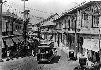
 Plaza Moraga in the early 1900s
 -
 The Old Legislative Building featuring a Neoclassical style architecture.
 -
-
 Aerial view of Manila, 1936


Japanese occupation era
[edit]

During the Japanese occupation of the Philippines, American soldiers were ordered to withdraw from Manila and all military installations were removed by December 24, 1941. Two days later, General Douglas MacArthur declared Manila an open city to prevent further death and destruction but Japanese warplanes continued bombing the city.[74] Japanese forces occupied Manila on January 2, 1942.[75]
From February 3 to March 3, 1945, Manila was the site of one of the bloodiest battles in the Pacific theater of World War II. Under orders of Japanese Rear Admiral Sanji Iwabuchi, retreating Japanese forces killed about 100,000 Filipino civilians and perpetrated the mass rape of women in February.[76][77] At the end of the war, Manila had suffered from heavy bombardment and became the second-most-destroyed city of World War II.[78][79] Manila was recaptured by American and Philippine troops.
The postwar and independence era
[edit]
After the war, reconstruction efforts started. Buildings like Manila City Hall, the Legislative Building (now the National Museum of Fine Arts), and Manila Post Office were rebuilt, and roads and other infrastructures were repaired. In 1948, President Elpidio Quirino moved the seat of government of the Philippines to Quezon City, a new capital in the suburbs and fields northeast of Manila, which was created in 1939 during the administration of President Manuel L. Quezon.[80] The move ended any implementation of the Burnham Plan's intent for the government center to be at Luneta. When Arsenio Lacson became the first elected Mayor of Manila in 1952, before which all mayors were appointed, Manila underwent a "Golden Age",[81] regaining its pre-war moniker "Pearl of the Orient". After Lacson's term in the 1950s, Manila was led by Antonio Villegas for most of the 1960s. Ramon Bagatsing was mayor from 1972 until the 1986 People Power Revolution.[82]
During the administration of Ferdinand Marcos, Metro Manila was created as an integrated unit with the enactment of Presidential Decree No. 824 on November 7, 1975. The area encompassed four cities and thirteen adjoining towns as a separate regional unit of government.[83] On June 24, 1976, the 405th anniversary of the city's founding, President Marcos reinstated Manila as the capital of the Philippines for its historical significance as the seat of government since the Spanish Period.[84][85] At the same time, Marcos designated his wife Imelda Marcos as the first governor of Metro Manila. She started the rejuvenation of the city and re-branded Manila the "City of Man".[86]
The Martial Law era
[edit]Many of the key events of the historical period from the first major protests against the administration of Ferdinand Marcos in January 1970 until his ouster in February 1986 took place within the city of Manila. The first, the January 26, 1970, State of the Nation Address Protest which kicked off the "First Quarter Storm", took place at the Legislative Building (now the National Museum of Fine Arts) on Padre Burgos Avenue,[87] and the very last saw the Marcos family flee Malacañang Palace into exile in the United States.[88][89][90]
The beginning weeks of Ferdinand Marcos' second term as president was marked by the 1969 balance of payments crisis, which economists trace to his first term tactic of using foreign loans to fund massive government projects in an effort to curry votes.[91][92][93] In protest, protest groups led mostly by students decided to picket Marcos' 1970 State of the Nation Address at the legislative building on January 26. The protesters were initially bickering amongst themselves because both moderate reformist and radical activist groups were present and fighting to gain control of the stage. But all of them, regardless of advocacy, were violently dispersed by the Philippine Constabulary.[94][95] This was followed by six more major protests which were violently dispersed, from the end of January until March 17, 1970.[89]
Instability continued the following year, with the most significant incident being the August 1971 Plaza Miranda bombing caused nine deaths and injured 95 others, including many prominent Liberal Party politicians including incumbent Senators Jovito Salonga, Eddie Ilarde, Eva Estrada-Kalaw, and Liberal Party president Gerardo Roxas, Sergio Osmeña Jr., Manila 2nd District Councilor Ambrosio "King" Lorenzo Jr., and Congressman Ramon Bagatsing who was the party's mayoral candidate for Manila.[95]
Marcos reacted to the bombing by blaming the still nascent Communist Party of the Philippines and then suspending of the writ of Habeas Corpus. The suspension is noted for forcing many members of the moderate opposition, including figures like Edgar Jopson, to join the ranks of the radicals. In the aftermath of the bombing, Marcos lumped all of the opposition together and referred to them as communists, and many former moderates fled to the mountain encampments of the radical opposition to avoid being arrested by Marcos' forces. Those who became disenchanted with the excesses of the Marcos administration and wanted to join the opposition after 1971 often joined the ranks of the radicals, simply because they represented the only group vocally offering opposition to the Marcos government.[96][97]
Marcos' declaration of martial law in September 1972 saw the immediate shutdown of all media not approved by Marcos, including Quezon City media outlets, including the Manila-based Manila Times, Philippines Free Press, The Manila Tribune and the Philippines Herald. At the same time, it saw the arrest of many students, journalists, academics, and politicians who were considered political threats to Marcos, many of them residents of the City of Manila. The first one was Ninoy Aquino who was arrested just before midnight on September 22 while at a hotel on UN Avenue preparing for a senate committee session the following morning.[95]
About 400 prominent critics of the Marcos administration were jailed in the first few hours of September 23 alone, and eventually about 70,000 individuals became Political detainees under the Marcos dictatorship - most of them arrested without warrants, which is why they were called detainees rather than prisoners.[98][99] At least 11,103 of them have since been officially recognized by the Philippine government as having been extensively tortured and abused.[100][101] and in April 1973 Pamantasan ng Lungsod ng Maynila student journalist Liliosa Hilao became the first of these detainees to be killed while in prison[102] - one of 3,257 known extrajudicial killings during the last 14 years of Marcos' presidency.[103]
In 1975, Marcos formalized the creation of a region called Metropolitan Manila, incorporating the four cities of Manila, Quezon City, Caloocan, Pasay, and the thirteen municipalities of Las Piñas, Makati, Malabon, Mandaluyong, Marikina, Muntinlupa, Navotas, Parañaque, Pasig, Pateros, San Juan, Taguig, and Valenzuela. And then he appointed his wife Imelda Marcos, who had been angered by the revelation of his dalliances during the Dovie Beams scandal, Governor of Metro Manila.[104]
Despite Marcos' declaration of martial law, poverty and other social issues persisted, so even with the military in his control, Marcos could not hold back the unrest. A major turning point was reached in Tondo in the form of the 1975 La Tondeña Distillery strike which was one of the first major open acts of resistance against the Marcos dictatorship which paved the way for similar protest actions elsewhere in the country.[105] From then, Manila continued to be a center of resistance activity; youth and student demonstrators repeatedly clashed with the police and military.[106]
Another major protest was the September 1984 Welcome Rotonda protest dispersal at the border of Manila and Quezon City, which came in the wake of the Aquino assassination the year before in 1983. International pressure had forced Marcos to give the press more freedom, so coverage exposed Filipinos to how opposition figures including 80-year-old former Senator Lorenzo Tañada and 71-year old Manila Times founder Chino Roces were waterhosed despite their frailty and how student leader Fidel Nemenzo (later Chancellor of the University of the Philippines Diliman) was shot nearly to death.[107][108][109]
The People Power revolution
[edit]In late 1985, in the face of escalating public discontent and under pressure from foreign allies, Marcos called a snap election with more than a year left in his term, selecting Arturo Tolentino as his running mate. The opposition to Marcos united behind Ninoy's widow Corazon Aquino and her running mate, Salvador Laurel.[110][111] The elections were held on February 7, 1986, an exercise marred by widespread reports of violence and tampering of election results.[112]
On February 16, 1986, Corazon Aquino held the "Tagumpay ng Bayan" (People's Victory) rally at Luneta Park, announcing a civil disobedience campaign and calling for her supporters to boycott publications and companies which were associated with Marcos or any of his cronies.[113] The event was attended by a crowd of about two million people.[114] Aquino's camp began making preparations for more rallies, and Aquino herself went to Cebu to rally more people to their cause.[115]
In the aftermath of the election and the revelations of irregularities, Juan Ponce Enrile and the Reform the Armed Forces Movement (RAM) - a cabal of disgruntled officers of the Armed Forces of the Philippines (AFP)[116] - set into motion a coup attempt against Ferdinand and Imelda Marcos.[117] Enrile and RAM's coup was quickly uncovered, which prompted Enrile to ask for the support of Philippine Constabulary chief Fidel Ramos. Ramos agreed to join Enrile but even so, their combined forces were trapped in Camp Crame and Camp Aguinaldo, and were about to be overrun by Marcos loyalist forces.[118][119][120]
Discovering what was happening, the forces which had been organizing Aquino's civil disobedience campaign went to the stretch of Efipanio De Los Santos Avenue (EDSA) between the two camps, beginning to form a human barricade to keep Marcos loyalist forces from attacking. The crowd grew even larger when Ramos telephoned Manila Cardinal Jaime Sin for help, and Sin went on Radyo Veritas to invite Catholics to join in protecting Enrile and Ramos.[121] Seeing what was happening, multiple units of the Armed Forces of the Philippines defected Marcos, with air units under the command of General Antonio Sotelo and Colonel Charles Hotchkiss, even performed calculated operations which included strafing the grounds of Malacañang palace with bullets and disabling gunships at nearby Villamor Airbase.[118]
The Reagan administration eventually decided to offer Marcos a chance to flee into exile. Shortly after midnight on February 26, 1986, the Marcos Family fled Malacañang and were taken to Clark Airbase, after which they went into exile in Honolulu along with some select followers including Fabian Ver and Danding Cojuangco.[88] Because the victory had been won by the civilians on the streets rather than the military, the event was dubbed the People Power revolution. Ferdinand Marcos' 21 years as President - and his 14 years as authoritarian leader - of the Philippines was over.[88][119]
Contemporary
[edit]
From 1986 to 1992, Mel Lopez was mayor of Manila, first due to presidential designation, before being elected in 1988.[122] In 1992, Alfredo Lim was elected mayor, the first Chinese-Filipino to hold the office. He was known for his anti-crime crusades. Lim was succeeded by Lito Atienza, who served as his vice mayor, and was known for his campaign and slogan "Buhayin ang Maynila" (Revive Manila), which saw the establishment of several parks, and the repair and rehabilitation of the city's deteriorating facilities. He was the city's mayor for nine years before being termed out of office. Lim once again ran for mayor and defeated Atienza's son Ali in the 2007 city election, and immediately reversed all of Atienza's projects,[123] which he said made little contribution to the improvements of the city. The relationship of both parties turned bitter, with them both contesting the 2010 city elections, which Lim won. Lim was sued by councilor Dennis Alcoreza on 2008 over human rights,[124] he was charged with graft over the rehabilitation of public schools.[125]
In 2012, DMCI Homes began constructing Torre de Manila, which became controversial for ruining the sight line of Rizal Park.[126] The tower became known as "Terror de Manila" and the "national photobomber",[127] and became a sensationalized heritage issue. In 2017, the National Historical Commission of the Philippines erected a "comfort woman" statue on Roxas Boulevard, causing Japan to express regret about the statue's erection despite the healthy relationship between Japan and the Philippines.[128][129]

In the 2013 election, former President Joseph Estrada succeeded Lim as the city's mayor. During his term, Estrada allegedly paid ₱5 billion in city debts and increased the city's revenues. In 2015, in line with President Noynoy Aquino's administration progress, the city became the most-competitive city in the Philippines. In the 2016 elections, Estrada narrowly won over Lim.[130] Throughout Estrada's term, numerous Filipino heritage sites were demolished, gutted, or approved for demolition; these include the post-war Santa Cruz Building, Capitol Theater, El Hogar, Magnolia Ice Cream Plant, and Rizal Memorial Stadium.[131][132][133] Some of these sites were saved after the intervention of governmental cultural agencies and heritage advocate groups.[134] In May 2019, Estrada said Manila was debt-free;[135] two months later, however, the Commission on Audit said Manila was ₱4.4 billion in debt.[136]
Estrada, who was seeking for re-election for his third and final term, lost to Isko Moreno in the 2019 local elections.[137][138] Moreno has served as the vice mayor under both Lim and Estrada. Estrada's defeat was seen as the end of their reign as a political clan, whose other family members run for national and local positions.[139] After assuming office, Moreno initiated a city-wide cleanup of illegal vendors, signed an executive order promoting open governance, and vowed to stop bribery and corruption in the city.[140] Under his administration, several ordinances were signed, giving additional perks and privileges to Manila's elderly people,[141] and monthly allowances for Grade 12 Manileño students in all public schools in the city, including students of Universidad de Manila and the University of the City of Manila.[142][143]
In 2022, Time Out ranked Manila in 34th position in its list of the 53 best cities in the world, citing it as "an underrated hub for art and culture, with unique customs and cuisine to boot". Manila was also voted the third-most-resilient and least-rude city for the year's index.[144][145] In 2023, the search site Crossword Solm utilizing internet geotagging, showed that Manila is the world's most loving capital city.[146]
.jpg)
In August 2023, President Bongbong Marcos suspended all reclamation projects in Manila Bay, including those in the City of Manila.[147] However, the city has no objections and is willing to pursue the suspended reclamation projects.[148]
In 2024, Manila, as the nation's seat of government, witnessed the launch of the Fourth Philippine Human Rights Plan, aimed at advancing social justice, inclusivity, and human rights protection in line with international standards.[149]
Geography
[edit].JPG)
_wiki.jpg)

The City of Manila is situated on the eastern shore of Manila Bay, on the western coast of Luzon, 1,300 km (810 mi) from mainland Asia.[150] The protected harbor on which Manila lies is regarded as the finest in Asia.[151] The Pasig River flows through the middle of city, dividing it into north and south.[152][153] The overall grade of the city's central, built-up areas is relatively consistent with the natural flatness of the natural geography, generally exhibiting only slight differentiation.[154]
Almost all of Manila sits on top prehistoric alluvial deposits built by the waters of the Pasig River and on land reclaimed from Manila Bay. Manila's land has been substantially altered by human intervention; there has been considerable land reclamation along the waterfronts since the early-to-mid twentieth century. Some of the city's natural variations in topography have been leveled. As of 2013[update], Manila had a total area of 42.88 square kilometers (16.56 sq mi).[152][153]
In 2017, the City Government approved five reclamation projects; the New Manila Bay–City of Pearl (New Manila Bay International Community) (407.43 hectares (1,006.8 acres)), Solar City (148 hectares (370 acres)), Manila Harbour Center expansion (50 hectares (120 acres)), Manila Waterfront City (318 hectares (790 acres)),[155] and Horizon Manila (419 hectares (1,040 acres)). Of the five planned projects, only Horizon Manila was approved by the Philippine Reclamation Authority in December 2019 and was scheduled for construction in 2021.[156]
Another reclamation project is possible and when built, it will include in-city housing relocation projects.[157] Environmental activists and the Catholic Church have criticized the land reclamation projects, saying they are not sustainable and would put communities at risk of flooding.[158][159] In line of the upcoming reclamation projects, the Philippines and the Netherlands agreed to a cooperation on the ₱250 million Manila Bay Sustainable Development Master Plan to oversee future decisions on projects on Manila Bay.[160]
Barangays and districts
[edit]

Manila is made up of 897 barangays,[161] which are grouped into 100 zones for statistical convenience. Manila has the most barangays of any metropolis in the Philippines.[162] Due to a failure to hold a plebiscite, attempts at reducing its number have not succeeded despite local legislation—Ordinance 7907, passed on April 23, 1996—reducing the number from 896 to 150 by merging existing barangays.[163]
- District I (2020 population: 441,282)[164] covers the western part of Tondo and is made up of 136 barangays. It is the most-densely populated congressional district and is also known as Tondo I. The district includes one of the biggest urban-poor communities; Smokey Mountain on Balut Island was once known as the country's largest landfill where thousands of impoverished people lived in slums. After the closure of the landfill in 1995, mid-rise housing was built on the site. This district also contains the Manila North Harbor Center, Manila North Harbor, and Manila International Container Terminal of the Port of Manila. The 1st District also covers Manila's borders with Navotas and a part of the southern enclave of Caloocan.
- District II (2020 population: 212,938)[164] covers the eastern part of Tondo and contains 122 barangays. It is also referred to as Tondo II. It includes Gagalangin, a prominent place in Tondo, and Divisoria, a popular shopping area and the site of the Main Terminal Station of the Philippine National Railways. The 2nd District also covers the rest of Manila's border with Caloocan.
- District III (2020 population: 220,029)[164] covers Binondo, Quiapo, San Nicolas and Santa Cruz. It contains 123 barangays and includes "Downtown Manila", the historic business district of the city, and the oldest Chinatown in the world. The 3rd District also covers a part of Manila's border with Quezon City.
- District IV (2020 population: 277,013)[164] covers Sampaloc and some parts of Santa Mesa. It contains 192 barangays and has numerous colleges and universities, which are located along the city's "University Belt", a de facto sub-district. Included here is the University of Santo Tomas, the oldest-existing university in Asia, which was established in 1611. The institution was home to at least 30 Catholic saints.[165][166] The 4th District also covers portions of Manila's borders with Quezon City and San Juan.
- District V (2020 population: 395,065)[164] covers Ermita, Malate, Port Area, Intramuros, San Andres Bukid, and a portion of Paco. It is made up of 184 barangays and includes Manila City Hall, Rizal Park, the historic Walled City, along with Manila Cathedral and San Agustin Church, a UNESCO World Heritage Site. The 4th District also covers portions of Manila's borders with Makati and Pasay. This district also includes the Manila South Cemetery, an exclave surrounded by Makati City.
- District VI (2020 population: 300,186)[164] covers Pandacan, San Miguel, Santa Ana, Santa Mesa, and the rest of Paco. It contains 139 barangays and includes Malacañang Palace, the residence and workplace of the President of the Philippines. Santa Ana district is known for its 18th century Santa Ana Church and historic ancestral houses. The 6th District also covers the rest of Manila's borders with Quezon City, San Juan, Makati and Pasay.
| District name | Legislative District number |
Area | Population (2020)[167] |
Density | Barangays | ||
|---|---|---|---|---|---|---|---|
| km2 | sq mi | /km2 | /sq mi | ||||
| Binondo | 3 | 0.6611 | 0.2553 | 20,491 | 31,000 | 80,000 | 10 |
| Ermita | 5 | 1.5891 | 0.6136 | 19,189 | 12,000 | 31,000 | 13 |
| Intramuros | 5 | 0.6726 | 0.2597 | 6,103 | 9,100 | 24,000 | 5 |
| Malate | 5 | 2.5958 | 1.0022 | 99,257 | 38,000 | 98,000 | 57 |
| Paco | 5 & 6 | 2.7869 | 1.0760 | 79,839 | 29,000 | 75,000 | 43 |
| Pandacan | 6 | 1.66 | 0.64 | 84,769 | 51,000 | 130,000 | 38 |
| Port Area | 5 | 3.1528 | 1.2173 | 72,605 | 23,000 | 60,000 | 5 |
| Quiapo | 3 | 0.8469 | 0.3270 | 29,846 | 35,000 | 91,000 | 16 |
| Sampaloc | 4 | 5.1371 | 1.9834 | 388,305 | 76,000 | 200,000 | 192 |
| San Andres | 5 | 1.6802 | 0.6487 | 133,727 | 80,000 | 210,000 | 65 |
| San Miguel | 6 | 0.9137 | 0.3528 | 18,599 | 20,000 | 52,000 | 12 |
| San Nicolas | 3 | 1.6385 | 0.6326 | 42,957 | 26,000 | 67,000 | 15 |
| Santa Ana | 6 | 1.6942 | 0.6541 | 203,598 | 120,000 | 310,000 | 34 |
| Santa Cruz | 3 | 3.0901 | 1.1931 | 126,735 | 41,000 | 110,000 | 82 |
| Santa Mesa | 6 | 2.6101 | 1.0078 | 111,292 | 43,000 | 110,000 | 51 |
| Tondo | 1 & 2 | 8.6513 | 3.3403 | 654,220 | 76,000 | 200,000 | 259 |
| |||||||
Climate
[edit].svg)
Under the Köppen climate classification system, Manila has a tropical monsoon climate (Köppen Am), closely bordering on a tropical savanna climate (Köppen Aw). Together with the rest of the Philippines, Manila lies entirely within the tropics. Its proximity to the equator means temperatures are high year-round especially during the daytime, rarely going below 19 °C (66.2 °F) or above 39 °C (102.2 °F). Temperature extremes have ranged from 14.5 °C (58.1 °F) on January 11, 1914,[168] to 38.6 °C (101.5 °F) on May 7, 1915.[169]
Humidity levels are usually very high all year round, making the air feel hotter than its actual temperature. Manila has a distinct dry season lasting from late December to early April. A relatively lengthy wet season that covers the remaining period, with slightly cooler daytime temperatures and slightly warmer nighttime temperatures. In the wet season, rain rarely falls all day, but rainfall is very heavy for short periods. Typhoons usually occur from June to September.[170]
| Climate data for Port Area, Manila (1991–2020, extremes 1885–2024) | |||||||||||||
|---|---|---|---|---|---|---|---|---|---|---|---|---|---|
| Month | Jan | Feb | Mar | Apr | May | Jun | Jul | Aug | Sep | Oct | Nov | Dec | Year |
| Record high °C (°F) | 36.5 (97.7) |
35.6 (96.1) |
36.8 (98.2) |
38.8 (101.8) |
38.6 (101.5) |
37.6 (99.7) |
37.0 (98.6) |
36.2 (97.2) |
35.3 (95.5) |
35.8 (96.4) |
35.6 (96.1) |
34.6 (94.3) |
38.8 (101.8) |
| Mean daily maximum °C (°F) | 29.9 (85.8) |
30.7 (87.3) |
32.1 (89.8) |
33.8 (92.8) |
33.6 (92.5) |
32.8 (91.0) |
31.5 (88.7) |
31.0 (87.8) |
31.2 (88.2) |
31.4 (88.5) |
31.3 (88.3) |
30.3 (86.5) |
31.6 (88.9) |
| Daily mean °C (°F) | 26.9 (80.4) |
27.5 (81.5) |
28.7 (83.7) |
30.3 (86.5) |
30.3 (86.5) |
29.7 (85.5) |
28.7 (83.7) |
28.5 (83.3) |
28.4 (83.1) |
28.6 (83.5) |
28.3 (82.9) |
27.4 (81.3) |
28.6 (83.5) |
| Mean daily minimum °C (°F) | 23.9 (75.0) |
24.3 (75.7) |
25.3 (77.5) |
26.7 (80.1) |
27.0 (80.6) |
26.5 (79.7) |
25.9 (78.6) |
25.9 (78.6) |
25.7 (78.3) |
25.7 (78.3) |
25.3 (77.5) |
24.6 (76.3) |
25.6 (78.1) |
| Record low °C (°F) | 14.5 (58.1) |
15.6 (60.1) |
16.2 (61.2) |
17.2 (63.0) |
20.0 (68.0) |
20.1 (68.2) |
19.4 (66.9) |
18.0 (64.4) |
20.2 (68.4) |
19.5 (67.1) |
16.8 (62.2) |
15.7 (60.3) |
14.5 (58.1) |
| Average rainfall mm (inches) | 19.4 (0.76) |
21.9 (0.86) |
21.8 (0.86) |
23.4 (0.92) |
159.1 (6.26) |
253.3 (9.97) |
432.3 (17.02) |
476.1 (18.74) |
396.4 (15.61) |
220.6 (8.69) |
119.9 (4.72) |
98.5 (3.88) |
2,242.7 (88.30) |
| Average rainy days (≥ 1.0 mm) | 4 | 3 | 3 | 3 | 9 | 14 | 19 | 19 | 18 | 14 | 10 | 8 | 124 |
| Average relative humidity (%) | 72 | 70 | 67 | 66 | 72 | 76 | 80 | 82 | 81 | 77 | 75 | 75 | 74 |
| Mean monthly sunshine hours | 177 | 198 | 226 | 258 | 223 | 162 | 133 | 133 | 132 | 158 | 153 | 152 | 2,105 |
| Source 1: PAGASA[171][172] | |||||||||||||
| Source 2: Danish Meteorological Institute (sun, 1931–1960)[173] | |||||||||||||
Natural hazards
[edit]Swiss Re ranked Manila as the second-riskiest capital city to live in, citing its exposure to natural hazards such as earthquakes, tsunamis, typhoons, floods, and landslides.[19] The seismically active Marikina Valley Fault System poses a threat of a large-scale earthquake with an estimated magnitude of between 6 and 7, and as high as 7.6[174] to Metro Manila and nearby provinces.[175] Manila has experienced several deadly earthquakes, notably those of 1645 and 1677, which destroyed the stone-and-brick medieval city.[176] Architects during the Spanish colonial period used the Earthquake Baroque style to adapt to the region's frequent earthquakes.[177]
Manila experiences between five and seven typhoons each year.[178] In 2009, Typhoon Ketsana (Ondoy) struck the Philippines, leading to one of the worst floods in Metro Manila and several provinces in Luzon with an estimated damages worth ₱11 billion (US$237 million),[179][180] and caused 448 deaths in Metro Manila alone. Following the aftermath of Typhoon Ketsana, the city began to dredge its rivers and improve its drainage network.
Parks and green spaces
[edit]
Metro Manila is situated in a variety of ecosystems including upland forests, mangrove forests, mudflats, sandy beaches, sea grass meadows and coral reefs. Metro Manila is home to urban parks, nature parks, plazas, nature reserves, and an arboretum. However, according to the Asian Green City Index, in 2007 Manila contained only an average of 4.5 square meters (48 sq ft) of green space per person, well below the index average of 39 square meters (420 sq ft)[182] and below the World Health Organization (WHO) recommended minimum of 9 square meters (97 sq ft) per person.[183][184]
The Arroceros Forest Park is a 2.2-hectare (5.4-acre) nature park situated in the heart of downtown Manila along the south bank of the Pasig River. Considered as the "last lung of Manila", the park was professionally planned in 1993 with its secondary growth forest of 61 different native tree varieties and 8,000 ornamental plants providing a habitat for about 10 different bird species.[185]
Pollution
[edit]_(Manila)(2018-02-07).jpg)
Air pollution in Manila is due to industrial waste and automobiles.[186][187] Swiss firm IQAir reported in December 2020 Manila experienced an average PM2.5 concentration of 6.1×10⁻⁶ g/m3 (1.03×10⁻⁸ lb/cu yd), which is classed as "Good" according to recommendations made by the World Health Organization.[188]
According to a report in 2003, the Pasig River is one of the most-polluted rivers in the world in which 150 metric tons (150 long tons; 170 short tons) of domestic waste and 75 metric tons (74 long tons; 83 short tons) of industrial waste are dumped daily.[189][needs update] The city is the second-biggest waste producing metropolis in the country with 1,151.79 tons (7,500.07 cubic meters (264,862 cu ft)) per day, after Quezon City, which produces 1,386.84 tons (12,730.59 cubic meters (449,577 cu ft)) per day. Both cities were cited as having poor management in garbage collection and disposal.[190] A 2021 report by Oxford University's Our World in Data estimated eighty one percent of global ocean plastic comes from rivers in Asia and the Philippines itself contributes one third of that number, and the Pasig River is one of the main contributors.[191]
Rehabilitation efforts have resulted in the creation of parks along the riverside and stricter pollution controls.[192][193] In 2019, the Department of Environment and Natural Resources launched a rehabilitation program for Manila Bay that will be administered by different government agencies.[194][195]
Cityscape
[edit]_-_Flickr.jpg)
Manila is a planned city. In 1905, American architect and urban planner Daniel Burnham was commissioned to design the new capital.[196] His design for the city was based on the City Beautiful movement, which favored broad streets and avenues radiating out from rectangles. Manila is made up of fourteen city districts, according to Republic Act No. 409—the Revised Charter of the City of Manila—the basis of which officially sets the present-day boundary of the city.[12] The districts Santa Mesa, which was partitioned from Sampaloc,[197] and San Andres, which was partitioned off from Santa Ana, were later created.
Manila's mix of architectural styles reflects its, and the Philippines', turbulent history. During World War II, Manila was razed to the ground by Japanese forces and the shelling of American forces.[198][199] After the war ended, rebuilding began and most of the historical buildings were reconstructed. Many of the historic churches and buildings in Intramuros, Manila's historic core, however, had been damaged beyond repair.[200] Manila's current urban landscape is one of modern and contemporary architecture. Manila's historic sites under the entry of The Walled City and Historic Monuments of Manila is currently being proposed to the tentative list for future UNESCO World Heritage Site inscription.[201]
Architecture
[edit]
_-_Flickr.jpg)
Manila is known for its eclectic mix of architecture that includes a wide range of styles spanning the city's historical and cultural periods. Its architectural styles reflect American, Spanish, Chinese, and Malay influences.[202] Prominent Filipino architects including Antonio Toledo,[203] Felipe Roxas,[204] Juan M. Arellano[205] and Tomás Mapúa have designed significant buildings in Manila such as churches, government offices, theaters, mansions, schools, and universities.[206]
Manila is known for its Art Deco theaters, some of which were designed by Juan Nakpil and Pablo Antonio.[207] The historic Escolta Street in Binondo has many buildings of Neoclassical and Beaux-Arts architectural styles, many of which were designed by prominent Filipino architects during the American colonial period between the 1920s and the late 1930s. Many architects, artists, historians, and heritage advocacy groups are campaigning for the restoration of Escolta Street, which was once the premier street of the Philippines.[208]

Almost all of Manila's pre-war and Spanish colonial architecture was destroyed during the 1945 Battle of Manila by intensive bombardment by the United States Air Force. Reconstruction took place afterward, replacing the destroyed historic Spanish-era buildings with modern ones, erasing much of the city's character. Some of the destroyed buildings, such as the Old Legislative Building (now the National Museum of Fine Arts), Ayuntamiento de Manila (now the Bureau of the Treasury), and the under-construction San Ignacio Church and Convent (as the Museo de Intramuros), have been reconstructed. There are plans to refurbish and restore several neglected historic buildings and places such as Plaza Del Carmen, San Sebastian Church, and the NCCA Metropolitan Theater. Spanish-era shops and houses in the districts of Binondo, Quiapo, and San Nicolas are also planned to be restored as a part of a movement to restore the city to its pre-war state.[209][210]
Because Manila is prone to earthquakes, Spanish colonial architects invented a style called Earthquake Baroque, which churches and government buildings during the Spanish colonial period adopted.[177] As a result, succeeding earthquakes of the 18th and 19th centuries barely affected Manila, although they periodically leveled the surrounding area. Modern buildings in and around Manila are designed or have been retrofitted to withstand an 8.2 magnitude quake in accordance with the country's building code.[211]
Demographics
[edit]| Year | Pop. | ±% p.a. |
|---|---|---|
| 1903 | 219,928 | — |
| 1918 | 285,306 | +1.75% |
| 1939 | 623,492 | +3.79% |
| 1948 | 983,906 | +5.20% |
| 1960 | 1,138,611 | +1.22% |
| 1970 | 1,330,788 | +1.57% |
| 1975 | 1,479,116 | +2.14% |
| 1980 | 1,630,485 | +1.97% |
| 1990 | 1,601,234 | −0.18% |
| 1995 | 1,654,761 | +0.62% |
| 2000 | 1,581,082 | −0.97% |
| 2007 | 1,660,714 | +0.68% |
| 2010 | 1,652,171 | −0.19% |
| 2015 | 1,780,148 | +1.43% |
| 2020 | 1,846,513 | +0.77% |
| 2024 | 1,902,590 | +0.72% |
| Source: Philippine Statistics Authority[212][213][214][215][216][217] | ||


According to the 2020 Philippine census, Manila has a population of 1,846,513 people, making it the second-most-populous city in the Philippines.[218] Manila is the most-densely populated city in the world, with 41,515 inhabitants per km2 in 2015.[7] District 6 is listed as the densest with 68,266 inhabitants per km2, followed by District 1 with 64,936 and District 2 with 64,710. District 5 is the least-densely populated area with 19,235.[219]
Manila has been presumed to be the Philippines' largest city since the establishment of a permanent Spanish settlement, and eventually became the political, commercial, and ecclesiastical capital of the country.[220] Since colonial times, Manila has been the destination of peoples whose origins are as wide-ranging as India[221] and Latin America.[222] Practicing forensic anthropology, while exhuming cranial bones in several Philippine cemeteries, researcher Matthew C. Go estimated that 7% of the mean amount, among the samples exhumed, have attribution to European descent.[223] Research work published in the Journal of Forensic Anthropology, collating contemporary Anthropological data show that the percentage of Filipino bodies who were sampled from the University of the Philippines, that is phenotypically classified as Asian (East, South and Southeast Asian) is 72.7%, Hispanic (Spanish-Amerindian Mestizo, Latin American, and/or Spanish-Malay Mestizo) is at 12.7%, Indigenous American (Native American) at 7.3%, African at 4.5%, and European at 2.7%.[224] However, this is only according to an interpretation of the data wherein the reference groups, which were cross checked to the Filipino samples; for the Hispanic category, were Mexican-Americans,[224] and the reference groups for the: European, African, and Indigenous American, categories, were: White Americans, Black Americans, and Native Americans from the USA, while the Asian reference groups were sourced from Chinese, Japanese, and Vietnamese origins.[224] In contrast, a different anthropology study using Morphoscopic ancestry estimates in Filipino crania using multivariate probit regression models by J. T. Hefner, while analyzing Historic and Modern samples of Philippine skeletons, paint a different picture,[225] in that, when the reference group for "Asian" was Thailand (Southeast Asians) rather than Chinese, Japanese, and Vietnamese; the reference for "Africans" included West and East Africans, along with Black Americans; and the reference group for "Hispanic" was Colombians (South Americans) rather than Mexicans,[225] the historical and modern sample results for Filipinos, yielded the following ratios: Asian at 48.6%, African at 32.9%, which is attributed to extensive admixture with Negritos since the initial peopling of the Filipino archipleago, and only a small portion classifying as either European at 12.9%, and finally for Hispanic at 5.7%.[225]
Between the 1860s and 1890s, in urban areas of the Philippines – especially Manila – according to burial statistics, as much as 3.3% of the population were pure European Spaniards and pure Chinese composed 9.9% of the city's populace. The Spanish-Filipino and Chinese-Filipino Mestizo populations also fluctuated, with the mixed Spanish-Filipinos composing 19% of Manila's population.[57]: 539 Eventually, these non-native categories diminished because they were assimilated into the majority Austronesian Filipino population.[226] During the Philippine Revolution, the term "Filipino" included people of any race born in the Philippines.[227][228] This explains the abrupt drop of the proportion of Chinese, Spanish, and Mestizo peoples across the country by the time of the first American census in 1903, as the foreign and mixed descended peoples identified solely as pure Filipinos.[229] Manila's population dramatically increased since the 1903 census because people tended to move from rural areas to towns and cities. In the 1960 census, Manila became the first Philippine city to exceed one million people – more than five times of its 1903 population. The city continued to grow until the population stabilized at 1.6 million and experienced alternating increases and decreases starting in the 1990 census year. This phenomenon may be attributed to the higher growth experienced by suburbs and the already-very-high population density of the city. As such, Manila exhibited a decreasing percentage share of the metropolitan population[230] from 63% in the 1950s to 27.5%[231] in 1980, and 13.8% in 2015. The much-larger Quezon City marginally surpassed the population of Manila in 1990 and by the 2015 census it already has 1.1 million more people. Nationally, the population of Manila was expected to be overtaken by cities with larger territories such as Caloocan and Davao City by 2020.[232] The vernacular language is Filipino, which is mostly based on the Tagalog language of the city and its surroundings, and this Manilan form of spoken Tagalog has become the lingua franca of the Philippines, having spread throughout the archipelago through mass media and entertainment. English is the language most widely used in education and business, and is in heavy everyday use throughout Metro Manila and the rest of the Philippines.
Philippine Hokkien, which is locally known as Lan-nang-oe, a variant of Southern Min, is mainly spoken by the city's Chinese-Filipino community. According to data provided by the Bureau of Immigration, 3.12 million Chinese citizens arrived in the Philippines from January 2016 to May 2018.[233]
Crime
[edit].jpg)
Crime in Manila is concentrated in areas that are associated with poverty, drug abuse, and gangs. Crime in the city is also directly related to its changing demographics and unique criminal justice system. The illegal drug trade is a major problem of the city; in Metro Manila alone, 92% of the barangays were affected by illegal drugs in February 2015.[234]
From 2010 to 2015, Manila had the second-highest index crime rates in the Philippines, with 54,689 cases or an average of about 9,100 cases per year.[235] By October 2017, Manila Police District (MPD) reported a 38.7% decrease in index crimes from 5,474 cases in 2016 to 3,393 in 2017. MPD's crime-solution efficiency also improved; six-to-seven of every ten crimes were solved by the city police force.[236] MPD was cited as the Best Police District in Metro Manila in 2017 for registering the highest crime-solution efficiency.[237]
Religion
[edit]- Catholicism (93.5%)
- Iglesia ni Cristo (1.90%)
- Protestantism (1.80%)
- Buddhism (1.10%)
- Other (1.40%)
Christianity
[edit]As a result of Spanish cultural influence, Manila is a predominantly Christian city. As of 2010[update], 93.5% of the population were Roman Catholic, 1.9% were adherents of the Iglesia ni Cristo, 1.8% followed various Protestant, and 1.1% were Buddhists. Members of Islam and other religions make up the remaining 1.4% of the population.[238]
Manila is the seat of prominent Catholic churches and institutions. There are 113 Catholic churches within the city limits; 63 of which are considered major shrines, basilicas, or cathedrals.[239] Manila Cathedral, the country's oldest established church, is the seat of the Roman Catholic Archdiocese of Manila.[240] There are another three basilicas in the city; Quiapo Church, Binondo Church, and the Minor Basilica of San Sebastián.[241] San Agustín Church in Intramuros is a UNESCO World Heritage Site.[242]
Several Mainline Protestant denominations are headquartered in the city. St. Stephen's Parish pro-cathedral in Santa Cruz district is the see of the Episcopal Church in the Philippines' Diocese of Central Philippines, while on Taft Avenue are the main cathedral and central offices of Iglesia Filipina Independiente (also called the Aglipayan Church), a nationalist church that is a product of the Philippine Revolution. The Church of Jesus Christ of Latter-day Saints (LDS Church) has a temple within Manila, one of two operating LDS temples in the Philippines.
The indigenous Iglesia ni Cristo has several locales (akin to parishes) in the city, including its first chapel, now a museum, in Punta, Santa Ana.[243] Evangelical, Pentecostal and Seventh-day Adventist denominations also thrive. The headquarters of the Philippine Bible Society is in Manila. The main campus of the Cathedral of Praise is located on Taft Avenue. Jesus Is Lord Church Worldwide has several branches and campuses in Manila.
Religious groups such as Members Church of God International (MCGI),[244] Iglesia ni Cristo, Jesus Is Lord Church Worldwide, and the El Shaddai movement celebrate their anniversaries at Quirino Grandstand, which is an open space in Rizal Park.[245]
-
 Manila Cathedral is the seat of Roman Catholic Archdiocese of Manila.
 -
![The Minor Basilica of San Sebastián is the only all-steel church in Asia.[246]](//upload.wikimedia.org/wikipedia/commons/thumb/5/50/San_Sebastian_Church%2C_Quiapo%2C_Manila%2C_Dec_2023.jpg/250px-San_Sebastian_Church%2C_Quiapo%2C_Manila%2C_Dec_2023.jpg)
-

-
 Binondo Church serves the Roman Catholic Chinese community.
 -
 Quiapo Church, home of the iconic Black Nazarene, whose Traslacion feast is celebrated every January 9

![The Minor Basilica of San Sebastián is the only all-steel church in Asia.[246]](https://en.wikipedia.org/wiki/File:San_Sebastian_Church,_Quiapo,_Manila,_Dec_2023.jpg)


Other faiths
[edit]Manila has many Taoist and Buddhist temples like Seng Guan Temple that serve the spiritual needs of the Chinese Filipino community.[247] Quiapo has a "Muslim town" that includes the city's largest mosque Masjid Al-Dahab.[248] Members of the Indian expatriate community can worship at the large Hindu temple in the city or at the Sikh gurdwara on United Nations Avenue. The Baháʼí Faith's governing body in the Philippines the National Spiritual Assembly is headquartered near Manila's eastern boundary with Makati.[citation needed]
Economy
[edit].jpg)
Manila is a major center for commerce, banking and finance, retailing, transportation, tourism, real estate, new media, traditional media, advertising, legal services, accounting, insurance, theater, fashion, and the arts. Around 60,000 establishments operate in the city.[249] In 2024, Manila is the 4th largest economy in the Philippines, with a 4.7% share to the national gross domestic product totaling ₱1.04 trillion.[250]
The National Competitiveness Council of the Philippines, which annually publishes the Cities and Municipalities Competitiveness Index (CMCI), ranks the country's cities, municipalities, and provinces according to their economic dynamism, government efficiency, and infrastructure. According to the 2022 CMCI, Manila was the second-most-competitive highly urbanized city in the Philippines.[251] Manila held the title of the country's most-competitive city in 2015, and since then has been in the top three, denoting Manila is consistently one of the best place to live in and do business.[252] The city has an estimated GDP of ₱987.88 billion[253] and is the 3rd largest economy of the National Capital Region, accounting for 15% of the region's total economy as of 2023.[254]
Binondo, the oldest and one of the largest Chinatowns in the world, was the center of commerce and business activities in the city. Numerous residential and office skyscrapers occupy its medieval streets. As of 2013, plans by the city government of Manila to turn the Chinatown area into a business process outsourcing (BPO) hub were in progress; thirty unoccupied buildings had been already identified for conversion into BPO offices. Most of these buildings are on Escolta Street, Binondo.[255]

The Port of Manila is the largest seaport in the Philippines and the main international shipping route into the country. The Philippine Ports Authority oversees the operation and management of the country's ports. International Container Terminal Services Inc., according to the Asian Development Bank, is one of the top-five major maritime terminal operators in the world,[256][257] and has its headquarters and main operations at the Port of Manila. Another port operator, Asian Terminal Incorporated, has its corporate office and main operations at Manila South Harbor, and its container depository is in Santa Mesa. Manila is classified as a Medium-Port Megacity, using the Southampton system for port-city classification.[258]
Manufacturers within the city produce industrial-related products such as chemicals, textiles, clothing, electronic goods, food, beverages, and tobacco products. Local businesses process primary commodities for export, including rope, plywood, refined sugar, copra, and coconut oil. The food-processing industry is one of the most-stable manufacturing sector in the city.[259]
.jpg)
Pandacan oil depot houses the storage facilities and distribution terminals of Caltex Philippines, Pilipinas Shell, and Petron Corporation; the major players in the country's petroleum industry. The oil depot has been a subject of various concerns, including its environmental and health impact on the residents of Manila. The Supreme Court ordered the oil depot to be relocated outside the city by July 2015,[260][261] but it failed to meet this deadline. Most of the oil depot facility inside the 33-hectare (82-acre) compound were demolished,[262] and plans have been made to convert it into a transport hub or food park.[263]
Manila is a major publishing center of the Philippines.[264] Manila Bulletin, the Philippines' largest broadsheet newspaper by circulation, is headquartered in Intramuros.[265] Other major publishing companies in the country The Manila Times, The Philippine Star, and Manila Standard Today are headquartered in the Port Area. The Chinese Commercial News, the Philippines' oldest existing Chinese-language newspaper, and the country's third-oldest newspaper,[266] is headquartered in Binondo. DWRK used to have its studio at the FEMS Tower 1 along Osmeña Highway in Malate before transferring to the MBC Building at the CCP Complex in 2008.[267]
Manila serves as the headquarters of the Bangko Sentral ng Pilipinas, which is located on Roxas Boulevard.[268] The Landbank of the Philippines and Philippine Trust Company also have their headquarters in Manila. Unilever Philippines used to have its corporate office on United Nations Avenue in Paco before transferring to Bonifacio Global City in 2016.[269] Vehicle manufacturer Toyota also has its regional office on UN Avenue.
Tourism
[edit]
Manila welcomes over one million tourists each year.[264] Major tourist destinations include the historic Walled City of Intramuros, the Cultural Center of the Philippines Complex,[note 1] Manila Ocean Park, Binondo (Chinatown), Ermita, Malate, Manila Zoo, the National Museum Complex, and Rizal Park.[270] Both the historic Walled City of Intramuros and Rizal Park were designated as flagship destinations and as tourism enterprise zones in the Tourism Act of 2009.[271]
Rizal Park, also known as Luneta Park, is a national park and the largest urban park in Asia.[272] with an area of 58 hectares (140 acres),[273] The park was constructed to honor of the country's national hero José Rizal, who was executed by the Spaniards on charges of subversion. The flagpole west of the Rizal Monument is the Kilometer Zero marker for distances to locations across the country. The park is managed by the National Parks and Development Committee.[274]
The 0.67-square-kilometer (0.26 sq mi) Walled City of Intramuros is the historic center of Manila. It is administered by the Intramuros Administration, an attached agency of the Department of Tourism. It contains Manila Cathedral and the 18th Century San Agustin Church, a UNESCO World Heritage Site. Kalesa is a popular mode of transportation for tourists in Intramuros and nearby places including Binondo, Ermita and Rizal Park.[275] Binondo, the oldest Chinatown in the world, was established in 1521[276] and served as a hub of Chinese commerce before the Spaniards colonized the Philippines. Its main attractions are Binondo Church, Filipino-Chinese Friendship Arch, Seng Guan Buddhist Temple, and authentic Chinese restaurants.
Manila is designated as the country's leading destination for medical tourism, which is estimated to annually generate $1 billion in revenue.[277] Lack of a progressive health system, inadequate infrastructure, and the unstable political environment are seen as hindrances to its growth.[278]
Shopping
[edit]

Manila is regarded as one of the best shopping destinations in Asia.[279][280] Major shopping malls, department stores, markets, supermarkets, and bazaars are located within the city.
Divisoria in Tondo has been locally described as a "shopping mecca" of Manila.[281][282] Shopping malls sell goods at bargain prices. Small vendors occupy several roads, causing pedestrian and vehicular traffic. A well-known landmark in Divisoria is the Tutuban Center, a large shopping mall that is a part of the Philippine National Railways' Main Station. It attracts 1 million people every month and is expected to add another 400,000 people upon the completion of the LRT Line 2 West Extension, making it Manila's busiest transfer station.[283] Another "lifestyle mall" is Lucky Chinatown. There are almost 1 million shoppers in Divisoria according to the Manila Police District.[284]
Binondo, the oldest Chinatown in the world,[49] is the city's center of commerce and trade for all types of businesses run by Filipino-Chinese merchants, with a wide variety of shops and restaurants. Quiapo is referred to as the "Old Downtown", where tiangges, markets, boutique shops, music and electronics stores are common.[285] Many department stores are on Recto Avenue.
Robinsons Place Manila is Manila's largest shopping mall.[286] The mall was the second and the largest Robinsons Malls built. SM Supermalls operates the shopping malls SM City Manila and SM City San Lazaro. SM City Manila is located on the former site of YMCA Manila beside Manila City Hall in Ermita, while SM City San Lazaro is built on the site of the former San Lazaro Hippodrome in Santa Cruz. The building of the former Manila Royal Hotel in Quiapo, which is known for its revolving restaurant, is now the SM Clearance Center and was established in 1972.[287] The site of the first SM Department Store is Carlos Palanca Sr. (formerly Echague) Street in San Miguel.[288]
Culture
[edit]Museums
[edit]_(digitally_altered_to_remove_Torre_de_Manila).jpg)
As the cultural center of the Philippines, Manila has a number of museums. The National Museum Complex of the National Museum of the Philippines, located in Rizal Park, is composed of the National Museum of Fine Arts, the National Museum of Anthropology, the National Museum of Natural History,[289] and the National Planetarium. Spoliarium, a famous painting by Juan Luna, can be found in the complex.[290]
The city hosts the National Library of the Philippines, a repository of the country's printed and recorded cultural heritage, and other literary and information resources.[291][292] The National Historical Commission of the Philippines maintains two history museums in the city, which are the Museo ni Apolinario Mabini – PUP and the Museo ni Jose Rizal – Fort Santiago.[293] Museums established or run by the National Library and by educational institutions such asDLS-CSB Museum of Contemporary Art and Design,[294] UST Museum of Arts and Sciences,[295] and the UP Museum of a History of Ideas are located in the city.[296]

Bahay Tsinoy, one of Manila's prominent museums, documents the lives of Chinese people and their contributions to the history of the Philippines.[297][298] Intramuros Light and Sound Museum chronicles Filipinos' desire for freedom during the revolution under Rizal's leadership and other revolutionary leaders. The Metropolitan Museum of Manila houses modern and contemporary visual arts, and exhibits Filipino arts and culture.[299]
Other museums in the city are the Museo Pambata,[300] a children's museum;[301] and Plaza San Luis, an outdoor heritage public museum that includes nine Spanish Bahay na Bato houses.[302] Ecclesiastical museums located in the city are the Parish of the Our Lady of the Abandoned in Santa Ana;[303] San Agustin Church Museum;[304] and the Museo de Intramuros, which houses the ecclesiastical art collection of the Intramuros Administration in the reconstructed San Ignacio Church and Convent.[305]
Sports
[edit].jpg)

Sports in Manila have a long and distinguished history. The city's, and in general the country's, main sport is basketball. Most barangays have a basketball court or a makeshift one, and court markings are frequently drawn on the streets. Larger barangays have covered courts where inter-barangay leagues are held every April to May. Manila's major sports venues include Rizal Memorial Sports Complex and San Andres Gym, the base of the now-defunct Manila Metrostars.[306]
Rizal Memorial Sports Complex houses a track and football stadium, a baseball stadium, tennis courts, Rizal Memorial Coliseum, and Ninoy Aquino Stadium; the latter two are indoor arenas. The Rizal complex had hosted several multi-sport events, such as the 1954 Asian Games and the 1934 Far Eastern Games. When the Philippines hosts the Southeast Asian Games, most of the events are held at the complex but in the 2005 Games, most events were held elsewhere. The 1960 ABC Championship and the 1973 ABC Championship, forerunners of the FIBA Asia Championship, were hosted at the memorial coliseum; the national basketball team won both tournaments.[307] The 1978 FIBA World Championship was held at the coliseum although the latter stages were held in the Araneta Coliseum in Quezon City.
Manila has several other well-known sports facilities such as Enrique M. Razon Sports Center and the University of Santo Tomas Sports Complex, both of which are private venues owned by a university; collegiate sports are also held in the city; the University Athletic Association of the Philippines and the National Collegiate Athletic Association basketball games held at Rizal Memorial Coliseum and Ninoy Aquino Stadium, although basketball events have been transferred to San Juan's Filoil Flying V Arena and Araneta Coliseum in Quezon City.
Other collegiate sports are still held at Rizal Memorial Sports Complex. Professional basketball, which has been mostly organized by corporate teams, also used to play at the city but the Philippine Basketball Association now holds their games at Araneta Coliseum and Cuneta Astrodome at Pasay; the now-defunct Philippine Basketball League played some of their games, such as its 1995–96 Philippine Basketball League season, at Rizal Memorial Sports Complex.[308]
Manila Metrostars participated in the Metropolitan Basketball Association.[309] The Metrostars, named after the Metrostar Express – the brand name of the Metro Manila MRT-3, which does not have stations in the city – participated in its first three seasons and won the 1999 championship.[310] The Metrostars later merged with the Batangas Blades and subsequently played in Lipa, Batangas. Almost twenty years later, Manila Stars participated in the Maharlika Pilipinas Basketball League, reaching the Northern Division Finals in 2019. Both teams played in the San Andres Sports Complex. Other teams that represented Manila but did not host games in the city are the Manila Jeepney F.C. and FC Meralco Manila. The city's government acknowledged Jeepney as Manila's representative in the United Football League. Meralco Manila played in the Philippines Football League and designated Rizal Memorial Stadium as their home ground.[citation needed]
Manila's rugby league team Manila Storm trains at Rizal Park and plays matches at Southern Plains Field, Calamba, Laguna. Baseball was previously a widely played sport in the city but in 2022, Manila had the Philippines' only sizable baseball stadium, Rizal Memorial Baseball Stadium, which hosted games of the now-defunct Baseball Philippines; Lou Gehrig and Babe Ruth were the first players to score a home run at the stadium during their tour of the country on December 2, 1934.[311] Cue sports are also popular in Manila; billiard halls are present in most barangays. The 2010 World Cup of Pool was held at Robinsons Place Manila.[312]
Rizal Memorial Track and Football Stadium hosted the first FIFA World Cup qualifier in decades when the Philippines hosted Sri Lanka in July 2011. The stadium, which was previously unfit for international matches, had been renovated before the match.[313] The stadium also hosted its first rugby test for the 2012 Asian Five Nations Division I tournaments.[314]
Festivals and holidays
[edit]
Manila celebrates civic and national holidays. Because most of the city's residents are Roman Catholic,[315][316] most of the festivals are religious in nature. Araw ng Maynila, which celebrates the city's founding on June 24, 1571[317] by the Spanish conquistador Miguel López de Legazpi, was first proclaimed by the city's vice mayor Herminio A. Astorga in June 1962. It has been annually commemorated under the patronage of John the Baptist, and has always been declared by the national government as a special, non-working holiday through presidential proclamations. Each of the city's 896 barangays have their own festivities, which are guided by their own patron saints.[citation needed]
Manila also hosts the procession of the Feast of the Black Nazarene (Traslacíon), which is held every January 9 and draws millions of Catholic followers.[318] Other religious festivities held in Manila are the Feast of Santo Niño in Tondo and Pandacan, which is held on the third Sunday of January;[319][320] the Feast of Nuestra Señora de los Desamparados de Manila (Our Lady of the Abandoned), the patron saint of Santa Ana, which is held every May 12;[321] and the Flores de Mayo.[322] Non-religious holidays include New Year's Day, National Heroes' Day, Bonifacio Day, and Rizal Day.[323]
Government
[edit]Local government
[edit].jpg)

Manila, which is officially known as the City of Manila, is the national capital of the Philippines and is classified as a special city according to its income,[324][325] and a highly urbanized city (HUC). The Mayor of Manila is the chief executive, and is assisted by the vice mayor and the 38-member City Council, who are elected as representatives of the six councilor districts within the city, and the municipal presidents of the Liga ng mga Barangay and Sangguniang Kabataan.[citation needed]
The city has no control over Intramuros and Manila North Harbor. The historic Walled City is administered by the Intramuros Administration while Manila North Harbor is managed by the Philippine Ports Authority. Both are national government agencies. The barangays that have jurisdictions over these places oversee the welfare of the city's constituents but cannot exercise their executive powers. Manila had a 12,971 personnel complement at the end of 2018.[326] Under the proposed form of federalism in the Philippines, Manila may no longer be the capital and Metro Manila may no longer be the seat of government; the committee has not yet decided on the federal capital and states they are open to other proposals.[327][328]
As of June 2025, the mayor is Isko Moreno, who is on his second mayoral stint. The vice mayor is Chi Atienza, daughter of former mayor Lito Atienza. The mayor and the vice mayor are limited to up-to three terms, each term lasting for three years. The city has an ordinance penalizing cat-calling since 2018, and is the second city in the Philippines to do so after Quezon City, which passed a similar ordinance in 2016.[329] In 2017, the city government planned to revise the existing curfew ordinance since the Supreme Court declared it unconstitutional in August that year. Of the three cities reviewed by the Supreme Court; the City of Manila, Navotas, and Quezon City; only the curfew ordinance of Quezon City was approved.[330][331]
National government
[edit].jpg)

Manila, being the seat of political power in the Philippines, has the headquarters of several national government offices. Planning for the city's role as the center of government started during the early years of American colonization, when the U.S. envisioned a well-designed city outside the walls of Intramuros, and chose Bagumbayan, a former town that is now Jose Rizal Park to become the center of government. A design commission was given to Daniel Burnham to create a master plan for the city patterned after Washington, D.C.[332] but the plans were abandoned under the Commonwealth Government of Manuel L. Quezon.[citation needed]
A new government center was to be built on the hills northeast of Manila, in what is now Quezon City. Several government agencies have set up their headquarters in Quezon City. Several key government offices are still based in Manila. Many of the plans were substantially altered after the devastation of Manila during World War II and by subsequent administrations.[citation needed]
As the nation's capital, Manila hosts the Office of the President and the President's official residence. It also houses important government agencies and institutions such as the Supreme Court, the Court of Appeals, the Bangko Sentral ng Pilipinas, the Departments of Budget and Management, Finance, Health, Justice, Labor and Employment, and Public Works and Highways. Manila also hosts important national institutions such as the National Library, National Archives, National Museum of the Philippines, and Philippine General Hospital.[citation needed] Other notable institutions based in Manila are the National Commission for Culture and the Arts, National Historical Commission, Film Development Council of the Philippines, and the Cultural Center of the Philippines.

Congress previously held office at the Old Congress Building.[333] In 1972, due to declaration of martial law, Congress was dissolved; its successor, the unicameral Batasang Pambansa, held office at the new Batasang Pambansa Complex. When a new constitution restored the bicameral Congress, the House of Representatives stayed at the Batasang Pambansa Complex and the Senate remained at the Old Congress Building. In May 1997, the Senate transferred to a new building, which it shares with the Government Service Insurance System on reclaimed land at Pasay. The Supreme Court was due to transfer to its new campus at Bonifacio Global City, Taguig, in 2019 but the move was postponed to a later year.[334]
In Congress, Manila has six representatives, one each from its six congressional districts.[335]
Finance
[edit]In the 2019 Annual Audit Report published by the Commission on Audit, the revenue of the City of Manila was ₱16.534 billion.[326] It is one of the cities with the highest tax collection and internal revenue allotment.[336] For the 2019 fiscal year, the tax revenue collected by the city was ₱8.4 billion. The city's Internal Revenue Allotment (IRA) from the National Treasury was ₱2.94 billion, and the city's total assets were worth ₱63.4 billion in 2019.[326] The City of Manila has the highest budget allocation for healthcare of all the cities and municipalities in the Philippines; the city maintains the six district hospitals, 59 health centers and lying-in clinics, and healthcare programs.[citation needed]
Infrastructure
[edit]Housing
[edit]
Development of public housing in Manila began in the 1930s under U.S. rule. Americans had to deal with the problem of sanitation and concentration of settlers around business areas.[337] Business codes and sanitation laws were implemented in the 1930s. During this period until the 1950s, new communities were opened for relocation. Among these were Projects 1–8 in Quezon City[338] and the Vitas tenement houses in Tondo.[339] In 1947, the government implemented a public housing policy that established the People's Homesite and Housing Corporation (PHHC).[340] A few years later, it established a Slum Clearance Committee which, with the help of the PHHC, relocated thousands of families from Manila and Quezon City to Sapang Palay in San Jose del Monte, Bulacan in the 1960s.[341]
In 2016, the national government completed several medium-rise houses for 300 Manila residents whose slum community was destroyed by a fire in 2011.[342] As of 2019, the city government plans to retrofit dilapidated tenements within the city,[343] and will construct new housing buildings for the city's informal settlers such as the 14-story Tondominium 1 and Tondomium 2 buildings, containing 42-square-meter (450 sq ft), two-bedroom units. The construction of these new in-city vertical housing projects was funded by a loan from the Development Bank of the Philippines and the Land Bank of the Philippines.[344][345]
Since 2019, the Manila City Government has initiated six housing projects: Tondominium 1 & 2, Binondominium, Basecommunity, San Lazaro Residences, Pedro Gil Residences, and San Sebastian Residences.[346][347][348]
Transportation
[edit]
(2018-02-22).jpg)

One of the best-known modes of transportation in Manila is the jeepney, which were patterned after U.S. Army jeeps and have been in use since the mid-to-late 1940s.[349] The Tamaraw FX, the third generation of the Toyota Kijang, once directly competed with jeepneys and followed fixed routes for a set price. They were replaced by the UV Express. All types of public road transportation in Manila are privately owned and operated under government-issued franchises.[citation needed]
On a for-hire basis, the city is served by taxicabs, "tricycles" – motorcycles with sidecars—the Philippine version of the auto rickshaw), and "trisikads", "sikads" or "kuligligs"; bicycles with sidecars, the Philippine version of pedicabs), which are popular In some areas, especially Divisoria. Spanish-era horse-drawn calesas are a popular tourist attraction and mode of transportation in Binondo and Intramuros. Manila will phase out all gasoline-run tricycles and pedicabs, and replace them with electric tricycles (e-trikes), and plans to distribute 10,000 e-trikes to qualified tricycle drivers from the city.[350][351] By January 2018, the city has distributed e-trikes to a number of drivers and operators in Binondo, Ermita, Malate, and Santa Cruz.[352]
Manila is serviced by LRT Line 1 (LRT-1) and Line 2 (LRT-2), which form the Manila Light Rail Transit System. Development of the light rail system began in the 1970s during the presidency of Ferdinand Marcos, when the LRT Line 1 was built, making it the first light-rail system in Southeast Asia. Despite its name, LRT-1 operates as a light metro, running on dedicated rights-of-way. LRT 2 operates as a full-metro, heavy rail system. As of 2015, these systems were undergoing a multi-billion-dollar expansion.[353] The LRT runs along the length of Taft Avenue (N170/R-2) and Rizal Avenue (N150/R-9), while LRT-2 runs along Claro M. Recto Avenue (N145/C-1) and Ramon Magsaysay Boulevard (N180/R-6) from Santa Cruz, through Quezon City, and to Masinag in Antipolo, Rizal.
_wiki.jpg)
Tutuban station, the central terminal of the Philippine National Railways, lies within Manila.[354][355] Within Metro Manila, one commuter railway is in operation. The line runs in a general north–south direction from Tutuban (Tondo) toward the province of Laguna. The Port of Manila, which is located in the western section of the city on Manila Bay, is the largest and chief seaport of the Philippines.[356] The Pasig River Ferry Service is another form of transportation.[357] The city is also served by Ninoy Aquino International Airport, the country's main international airport and domestic air hub.[358]
Trolleys, hand-made human-powered metal handcarts operated by "trolley boys", transport people along sections of the PNR lines. This is a popular means of transportation because it is low-cost – roughly ₱10 or US$.20 per trip – and avoids traffic. Many trolley boys are homeless and live alongside the railroad line, which is actively used by passenger trains, making collisions with passenger trains a consistent danger, although casualties are rare. The trolley rides are unofficial and unregulated but tolerated by authorities.[359][360][361][362]
Satellite navigation company TomTom ranked Manila as the second world's most-traffic-congested city in 2019.[363] According to Waze's 2015 "Global Driver Satisfaction Index", Manila has the worst traffic worldwide.[364] Manila is notorious for its frequent traffic jams and high densities.[365] The government has undertaken several projects to alleviate the traffic in the city, some of which include the proposed construction of a new viaduct or underpass at the intersection of España Boulevard and Lacson Avenue;[366] the construction of Skyway Stage 3, and NLEX Connector; the proposed LRT Line 2 West Extension Project from Recto Avenue to Pier 4 of Manila North Harbor;[367] the construction of the North–South Commuter Railway (NSCR);[368] the proposed construction of the PNR East–West line (MRT Line 8) through España Boulevard to Quezon City; and the expansion and widening of several national and local roads. These projects had yet to make any meaningful impact by 2014, and the traffic jams and congestion continue.[369]
The government, under its 2014 Metro Manila Dream Plan aims to address these urban transport problems. The plan is a list of short-term priority projects and medium-to-long-term infrastructure projects that will last up to 2030.[370][371]
Water and electricity
[edit]Water services used to be provided by the Metropolitan Waterworks and Sewerage System (MWSS), which served 30% of the city. Most other sewage was directly dumped into storm drains, septic tanks, and open canals.[372] MWSS was privatized in 1997, which split the water concession into east and west zones. Maynilad Water Services took over the west zone, of which Manila is a part.[373]
As of 2001, Maynilad Water Services provides the supply and delivery of potable water, and sewerage system in Manila.[374] The southeastern part of the city, which belongs to the east zone, is served by Manila Water.[375] Electricity services are provided by Meralco, the sole electricity distributor in Metro Manila.[376]
Healthcare
[edit]_(2014).JPG)
Manila Health Department is responsible for the planning and implementation of healthcare programs provided by the city government. Manila Health Department operates 59 health centers and six city-run hospitals, which are free of charge for the city's constituents. The six public city-run hospitals are Ospital ng Maynila Medical Center, Ospital ng Sampaloc, Gat Andres Bonifacio Memorial Medical Center, Ospital ng Tondo, Santa Ana Hospital, and Justice Jose Abad Santos General Hospital.[378] Philippine General Hospital, a tertiary state-owned hospital in Manila, is operated by the University of the Philippines Manila. The city is planning to build an education, research, and hospital facility for cleft lip and cleft palate patients,[379][380] and to establish the first children's surgical hospital in Southeast Asia.[381]
Private corporations also provide healthcare in Manila. Private hospitals that operate in the city are Manila Doctors Hospital,[382] Chinese General Hospital and Medical Center,[383] José R. Reyes Memorial Medical Center,[384] Metropolitan Medical Center,[385] Our Lady of Lourdes Hospital,[386] and the University of Santo Tomas Hospital.[387]
The Department of Health (DOH) has its main office in Manila[388] and operates San Lazaro Hospital, a special referral tertiary hospital. DOH also operates Dr. Jose Fabella Memorial Hospital, Jose R. Reyes Memorial Medical Center, and Tondo Medical Center.[389] Manila is the home to the headquarters of the World Health Organization's Regional Office for the Western Pacific and Country Office for the Philippines.[390]
The city government provides free immunization programs for children, who are specifically targeted against hepatitis B, hemophilus influenza B pneumonia, diphtheria, tetanus, polio, measles, mumps, and rubella. As of 2016, 31,115 children aged one and below have been fully immunized.[391] Manila Dialysis Center, which provides free services for the poor, has been cited by the United Nations Committee on Innovation, Competitiveness and Public-Private Partnerships as a model for public-private partnership (PPP) projects.[392][393] The dialysis facility was named Flora V. Valisno de Siojo Dialysis Center in 2019, and was inaugurated as the largest free dialysis facility in the Philippines. It has 91 dialysis machines, which can be expanded up to 100, matching the capabilities of the National Kidney and Transplant Institute (NKTI).[394][395]
Education
[edit]

Manila has been a center of education since the colonial period.[396] The city has several Philippine universities and colleges, some of which are the county's oldest. The city's University Belt has a high concentration of colleges and universities, which are a short walking distance of each other. The University Belt is at the boundaries between San Miguel, Quiapo, and Sampaloc districts, while other clusters colleges lie along the southern bank of the Pasig River – mostly in Intramuros and Ermita districts; and at the southernmost part of Malate near the city limits.
The historic district Intramuros once housed the University of Santo Tomas (1611), Colegio de San Juan de Letran (1620), and Ateneo de Manila University (1859).[396][397] Only Colegio de San Juan de Letran remains at Intramuros; the University of Santo Tomas transferred to a new campus at Sampaloc in 1927 and Ateneo de Manila University relocated to Loyola Heights, Quezon City, in 1952. In the 20th century, new non-sectarian schools were built; Mapúa University (1925), Lyceum of the Philippines University (1952), and Pamantasan ng Lungsod ng Maynila (1965) – which is owned and operated by the Manila city government.[398][399] The four schools in the district formed the Intramuros Consortium.
Other notable universities in Manila include National University (1900), San Beda University (1901), the only Benedictine university in Asia, De La Salle University (1911), the largest of all De La Salle University System of schools, St. Paul University Manila (1912), one of the seven campuses comprising the St. Paul University System of schools, Far Eastern University (1928), and Adamson University (1939).
The University of the Philippines (1908), the country's main state university, was established in Ermita, Manila. It moved its central administrative offices from Manila to Diliman in 1949 and eventually made the original campus the University of the Philippines Manila, the oldest of the constituent universities of the University of the Philippines System, and the center of health-sciences education in the country.[400] Manila is also the site of the main campus of the Polytechnic University of the Philippines, the largest university in the country in terms of student population.[401]
The city's three-tier public education system, the Division of the City Schools of Manila, is a branch of the Department of Education. The division oversees 71 public elementary schools and 32 public high schools, all located within the city's territory, except for Rafael Palma Elementary School, which is situated in Barangay La Paz, Makati, near the border with Manila.[402] The city also contains Manila Science High School, a pilot science high school.[403]
Sister cities
[edit]Asia
[edit] Astana, Kazakhstan[404]
 Bacoor, Cavite[405]
 Bangkok, Thailand[406]
 Beijing, People's Republic of China[407][408]
 Dili, East Timor[409][410]
- Guangzhou, Guangdong, People's Republic of China[408]
 Haifa, Israel[411]
 Ho Chi Minh City, Vietnam[412]
 Incheon, South Korea[413]
 Jakarta, Indonesia[414]
 Nantan, Kyoto, Japan[415]
 Osaka, Japan (business partner)[416]
- Shanghai, People's Republic of China[417]
 Taipei, Taiwan[418]
 Takatsuki, Osaka, Japan[419][420]
 Yokohama, Kanagawa, Japan[420][421]
Europe
[edit]The Americas
[edit] Acapulco, Guerrero, Mexico[425]
 Buenos Aires, Argentina[426]
 Cali, Colombia
 Cartagena, Colombia[404]
 Havana, Cuba[404]
 Lima, Peru[404]
 Mexico City, Mexico
 Montevideo, Uruguay[427]
 Montreal, Quebec, Canada[428]
 New York City, New York, United States (global partner)[429]
 Panama City, Panama[430]
 Sacramento, California, United States
 San Francisco, California, United States[431]
 Santiago, Chile[404]
 Winnipeg, Manitoba, Canada[432]
Oceania
[edit]International relations
[edit]Manila hosts the foreign embassies of the United States[436] and Vietnam.[437] Honorary consulates of Belize, Burkina Faso, Jordan, Nepal, Poland, Iceland, Paraguay, Thailand, and Tunisia are based in the city.[438]
Notable personalities
[edit]See also
[edit]Notes
[edit]- ^ /məˈnɪlə/ mə-NIL-ə; Filipino: Maynila, IPA: [maɪˈniː.lɐʔ]
- ^ Filipino: Lungsod ng Maynila, IPA: [luŋˈsod nɐŋ maɪˈniː.lɐʔ]
- ^ This was spurred by a locally found sacred image, i.e., a Black Madonna of unknown origin; one theory is that it is from Portuguese-Macau, another is that it is a Tantric goddess and this was worshiped by the natives in a Pagan-Hindu manner and had survived Islamic iconoclasm by the Sultanate of Brunei. This image was interpreted to be of Marian nature, and it was found during the Miguel de Legazpi expedition and eventually, a Mexican hermit built a chapel around that image.
References
[edit]- ^ "'Pearl of Orient' Stripped of Food; Manila, Before Pearl Harbor, Had Been Prosperous—Its Harbor One, of Best Focus for Two Attacks Osmeña Succeeded Quezon". New York Times. February 5, 1945. Retrieved March 3, 2014.
Manila, modernized and elevated to the status of a metropolis by American engineering skill, was before Pearl Harbor a city of 623,000 population, contained in an area of 14 square miles (36 km2).
- ^ [https://lgu201.dilg.gov.ph/view.php?r=13&p=39
- ^ "Manila". City Government of Manila.
- ^ "Mappa topografica Manila" (in Italian). Retrieved November 5, 2024.
- ^ "2024 Census of Population (POPCEN) Population Counts Declared Official by the President". Philippine Statistics Authority. July 17, 2025. Retrieved July 18, 2025.
- ^ a b Census of Population (2020). Table B - Population and Annual Growth Rates by Province, City, and Municipality - By Region. Philippine Statistics Authority. Retrieved July 8, 2021.
- ^ a b c "Philippine Population Density (Based on the 2015 Census of Population)". Philippine Statistics Authority. Retrieved November 2, 2017.
- ^ The original form as used by José Rizal in El filibusterismo.
- ^ "Poverty Statistics". Philippine Statistics Authority. August 15, 2024. Retrieved December 19, 2024.
- ^ Sub-national HDI. "Area Database – Global Data Lab". hdi.globaldatalab.org.
- ^ "2024 Census of Population (POPCEN) Population Counts Declared Official by the President". Philippine Statistics Authority. July 17, 2025. Retrieved July 18, 2025.
- ^ a b Republic Act No. 409 (June 18, 1949), Revised Charter of the City of Manila, Official Gazette, archived from the original on August 31, 2017, retrieved June 30, 2015
- ^ "Annual Audit Report: City of Manila" (PDF). Commission on Audit. 2014. Archived from the original on November 4, 2016. Retrieved November 4, 2016.
- ^ China and the Birth of Globalization in the 16th Century, by Dennis O. Flynn and Arturo Giráldez
- ^ Frank, Andre G. (1998). ReOrient: Global Economy in the Asian Age. Berkeley: University of California Press. pp. 131. ISBN 9780520214743.
- ^ "GaWC – The World According to GaWC 2018". www.lboro.ac.uk. Archived from the original on August 10, 2020. Retrieved February 28, 2020.
- ^ "Brookings – Global Metro Monitor 2018". www.brookings.edu. November 30, 2001. Retrieved April 6, 2020.
- ^ "The Global Financial Centres Index 27" (PDF). Long Finance. March 2020. Retrieved April 5, 2020.
- ^ a b Lozada, Bong (March 27, 2014). "Metro Manila is world's second riskiest capital to live in–poll". Philippine Daily Inquirer. Retrieved April 9, 2014.
- ^ "Global Metro Monitor". Brookings Institution. January 22, 2015. Retrieved April 12, 2017.
- ^ a b c d e f Baumgartner, Joseph (March 1975). "Manila – Maynilad or Maynila?". Philippine Quarterly of Culture and Society. 3 (1): 52–54. JSTOR 29791188.
- ^ a b c Reyes, Wensley M.; Mataac, Trisha Anne M. (2025). "Ang Pagbabalik ng "Nilad": Kasaysayan ng Isang Toponimo". In Navarro, Atoy M.; Reyes, Wensley M. (eds.). Maestra sa Maynila: Kalipunan ng mga Saliksik sa Araling Maynila at Aklat-Parangal Kay Dr. Celestina P. Boncan (in Filipino). Manila: Department of Social Sciences, University of the Philippines Manila. pp. 21–82. ISBN 978-621-96068-9-9.
- ^ Chamberlain, Alexander F. (1901). "Philippine Studies: V. The Origin of the Name Manila". The American Antiquarian and Oriental Journal. 23 (5): 33.
- ^ Thomas, Hugh (August 11, 2015). World Without End: Spain, Philip II, and the First Global Empire. Random House Publishing Group. ISBN 978-0-8129-9812-2. Retrieved March 28, 2022.
- ^ "Ixora manila Blanco". World Marine Species Database. Retrieved August 20, 2018.
- ^ Merrill, Elmer Drew (1903). A Dictionary of the Plant Names of the Philippine Islands. Manila: Bureau of Public Printing.
- ^ Aloma Monte de los Santos (1994). Parish of Santo Niño de Molino – Bacoor, Cavite – 1984–1994: The Making of a Parish. Parish of Santo Niño de Molino. Retrieved August 20, 2018.
- ^ Rolfe, R.A. (1886) On the flora of Philippine Islands and its probable derivation. The Journal of the Linnean Society - Botany 21: 285.
- ^ Ray, John; Camel, Georg Joseph; Tournefort, Joseph Pitton de (1686). Historia plantarum : species hactenus editas aliasque insuper multas noviter inventas & descriptas complectens. Vol. 3 ([Large paper issue] ed.). Londini: Typis Mariæ Clark, prostant apud Henricum Faithorne [etc.] p. 86.
- ^ Mijares, Armand Salvador B. (2006). .The Early Austronesian Migration To Luzon: Perspectives From The Peñablanca Cave Sites Archived July 7, 2014, at the Wayback Machine. Bulletin of the Indo-Pacific Prehistory Association 26: 72–78.
- ^ Junker, Laura Lee (2000). Raiding, Trading, and Feasting: The Political Economy of Philippine Chiefdoms. Quezon City: Ateneo de Manila University Press. pp. 184–192. ISBN 978-9715503471.
- ^ Wakan Sansai Zue, Pages 202-216
- ^ Reading Song-Ming Records on the Pre-colonial History of the Philippines By Wang Zhenping Page 256.
- ^ Lopez, V.B. (April 1, 1974). "Culture Contact and Ethnogenesis in Mindoro up to the End of the Spanish Rule". The Asian Center. 12 (1): 3 – via Asian Studies: Journal of Critical Perspectives on Asia.
- ^ Joaquin, Nick (1990). Manila, My Manila: A History for the Young. City of Manila: Anvil Publishing, Inc. ISBN 978-971-569-313-4.
- ^ Wright, Hamilton M. (1907). "A Handbook of the Philippines", p. 143. A.C. McClurg & Co., Chicago.
- ^ Kane, Herb Kawainui (1996). "The Manila Galleons". In Bob Dye (ed.). Hawaiʻi Chronicles: Island History from the Pages of Honolulu Magazine. Vol. I. Honolulu: University of Hawaii Press. pp. 25–32. ISBN 978-0-8248-1829-6.
- ^ The "Indo-Pacific" Crossroads: The Asian Waters as Conduits of Knowledge, People, Cargoes, and Technologies Page 107 (Citing:"Wang 1953; Tanaka Takeo 1961.")
- ^ Bartolome Juan Leonardy y de Argensola, Conquistas de las islas Molucas (Madrid: Alonso Martin, 1909) pp. 351-8; Cesar Majul, Muslims in the Philippines (Quezon City: University of the Philippines Press, 1973) pp. 119-20; Hal, History of Southeast Asia, pp. 249-50.
- ^ Peter Borschberg (2015). Journal, Memorials and Letters of Cornelis Matelieff de Jonge. Security, Diplomacy and Commerce in 17th-Century Southeast Asia. Singapore: NUS Press. pp. 82, 84, 126, 421. Retrieved August 30, 2015.
- ^ Zamboangueño Chavacano: Philippine Spanish Creole or Filipinized Spanish Creole? By Tyron Judes D. Casumpang (Page 3)
- ^ Gordon, Peter; Morales, Juan José (April 8, 2017). The Silver Way: China, Spanish America and the Birth of Globalisation, 1565-1815. Penguin Books. ISBN 978-0-7343-9943-4 – via Google Books.
- ^ Bhattacharya, Bhaswati (March 2008). "Making money at the blessed place of Manila: Armenians in the Madras–Manila trade in the eighteenth century*". Journal of Global History. 3 (1): 1–20. doi:10.1017/S1740022808002416. ISSN 1740-0236.
- ^ "Manila (Philippines)". Britannica. Retrieved March 3, 2014.
- ^ Backhouse, Thomas (1765). The Secretary at War to Mr. Secretary Conway. London: British Library. pp. v. 40.
- ^ Fish, Shirley (2003). When Britain Ruled The Philippines 1762–1764. 1stBooks. p. 158. ISBN 978-1-4107-1069-7.
- ^ "Wars and Battles: Treaty of Paris (1763)". www.u-s-history.com.
- ^ Barrows, David (2014). "A History of the Philippines". Guttenburg Free Online E-books. 1: 179.
Within the walls, there were some six hundred houses of a private nature, most of them built of stone and tile, and an equal number outside in the suburbs, or "arrabales", all occupied by Spaniards ("todos son vivienda y poblacion de los Españoles"). This gives some twelve hundred Spanish families or establishments, exclusive of the religious, who in Manila numbered at least one hundred and fifty, the garrison, at certain times, about four hundred trained Spanish soldiers who had seen service in Holland and the Low Countries, and the official classes.
- ^ a b Raitisoja, Geni " Chinatown Manila: Oldest in the world" Archived April 2, 2011, at the Wayback Machine, Tradio86.com, July 8, 2006, accessed March 19, 2011.
- ^ "In 1637 the military force maintained in the islands consisted of one thousand seven hundred and two Spaniards and one hundred and forty Indians." ~Memorial de D. Juan Grau y Monfalcon, Procurador General de las Islas Filipinas, Docs. Inéditos del Archivo de Indias, vi, p. 425. "In 1787 the garrison at Manila consisted of one regiment of Mexicans comprising one thousand three hundred men, two artillery companies of eighty men each, three cavalry companies of fifty men each." La Pérouse, ii, p. 368.
- ^ (Page 10) Pérez, Marilola (2015). Cavite Chabacano Philippine Creole Spanish: Description and Typology (PDF) (PhD). University of California, Berkeley. Archived from the original on January 14, 2021.
The galleon activities also attracted a great number of Mexican men that arrived from the Mexican Pacific coast as ships' crewmembers (Grant 2009: 230). Mexicans were administrators, priests and soldiers (guachinangos or hombres de pueblo) (Bernal 1964: 188) many though, integrated into the peasant society, even becoming tulisanes "bandits" who in the late 18th century "infested" Cavite and led peasant revolts (Medina 2002: 66). Meanwhile, in the Spanish garrisons, Spanish was used among administrators and priests. Nonetheless, there is not enough historical information on the social role of these men. In fact some of the few references point to a quick integration into the local society: "los hombres del pueblo, los soldados y marinos, anónimos, olvidados, absorbidos en su totalidad por la población Filipina." (Bernal 1964: 188). In addition to the Manila-Acapulco galleon, a complex commercial maritime system circulated European and Asian commodities including slaves. During the 17th century, Portuguese vessels traded with the ports of Manila and Cavite, even after the prohibition of 1644 (Seijas 2008: 21). Crucially, the commercial activities included the smuggling and trade of slaves: "from the Moluccas, and Malacca, and India... with the monsoon winds" carrying "clove spice, cinnamon, and pepper and black slaves, and Kafir [slaves]" (Antonio de Morga cf Seijas 2008: 21)." Though there is no data on the numbers of slaves in Cavite, the numbers in Manila suggest a significant fraction of the population had been brought in as slaves by the Portuguese vessels. By 1621, slaves in Manila numbered 1,970 out of a population of 6,110. This influx of slaves continued until late in the 17th century; according to contemporary cargo records in 1690, 200 slaves departed from Malacca to Manila (Seijas 2008: 21). Different ethnicities were favored for different labor; Africans were brought to work on the agricultural production, and skilled slaves from India served as caulkers and carpenters.
- ^ "Jesuits In The Philippines (1581-1768)" Page 132 "In 1591 there arrived in Manila a secular priest named Juan Fernandez de Leon. He had led a hermit's life in Mexico and planned to continue it in the Philippines. For this purpose he built himself a retreat near a wayside shrine just outside the city walls which was dedicated to Our Lady of Guidance, Nuestra Sehora de Guia. His hermitage later gave its name to the entire district, which is called Ermita to this day."
- ^ Mawson, Stephanie J. (August 1, 2016). "Convicts or Conquistadores ? Spanish Soldiers in the Seventeenth-Century Pacific". Past & Present (232): 87–125. doi:10.1093/pastj/gtw008. ISSN 0031-2746.
- ^ "West Coast of the Island Of Luzon | Tourist Attractions". Archived from the original on December 6, 2016. Retrieved December 6, 2016.
- ^ Patricia Flannery, Kristie (April 3, 2023). "Colonial Latin Asia? The case for incorporating the Philippines and the Spanish Pacific into colonial Latin American studies". Colonial Latin American Review. 32 (2): 235–242. doi:10.1080/10609164.2023.2205233.
- ^ John. M. Lipski, with P. Mühlhaüsler and F. Duthin (1996). "Spanish in the Pacific" (PDF). In Stephen Adolphe Wurm & Peter Mühlhäusler (ed.). Atlas of Languages of Intercultural Communication in the Pacific, Asia, and the Americas: Texts, Volume 2. Walter de Gruyter. p. 276. ISBN 9783110134179.
- ^ a b c "ESTADISMO DE LAS ISLAS FILIPINAS TOMO PRIMERO By Joaquín Martínez de Zúñiga (Original Spanish)" (PDF). Archived (PDF) from the original on March 9, 2016. Retrieved February 3, 2024.
- ^ The Age of Trade: The Manila Galleons and the Dawn of the Global Economy by Arturo Giraldez
- ^ Robertson, James Alexander; Blair, Emma Helen (1906). The Philippine Islands, 1493–1898. Vol. XLIV. p. 29. Retrieved September 24, 2013.
- ^ Bartolomé de Letona, La perfecta religiosa (Puebla, 1662), as quoted in Irving, Colonial Counterpoint, page 245
- ^ "Connecting the Indies: the hispano-asian Pacific world in early Modern Global History". ResearchGate.
- ^ Criado, Buenaventura Delgado, ed. (1992). Historia de la educación en España y América (in Spanish). Vol. 3: La educación en la España contemporánea (1789–1975). Madrid: Fundación Santa María. p. 508. ISBN 978-84-7112-378-7.
- ^ John Bowring, "Travels in the Philippines", p. 18, London, 1875
- ^ Olsen, Rosalinda N. "Semantics of Colonization and Revolution". www.bulatlat.com. Retrieved January 8, 2011.
- ^ "Filipinos In Mexico's History 4 (The Mexican Connection – The Cultural Cargo Of The Manila-Acapulco Galleons) By Carlos Quirino". Archived from the original on August 4, 2020. Retrieved April 22, 2021.
- ^ Beede, Benjamin R. (May 1, 1994). The War of 1898 and U.S. Interventions, 1898T1934: An Encyclopedia. Routledge. pp. 417-418. ISBN 978-1-136-74690-1. Retrieved March 28, 2022.
- ^ The text of the amended version published by General Otis is quoted in its entirety in José Roca de Togores y Saravia; Remigio Garcia; National Historical Institute (Philippines) (2003), Blockade and siege of Manila, National Historical Institute, pp. 148–150, ISBN 978-971-538-167-3
See also s:Letter from E.S. Otis to the inhabitants of the Philippine Islands, January 4, 1899. - ^ Magoc, Chris J.; Bernstein, David (December 14, 2015). Imperialism and Expansionism in American History: A Social, Political, and Cultural Encyclopedia and Document Collection [4 volumes]: A Social, Political, and Cultural Encyclopedia and Document Collection. ABC-CLIO. p. 731. ISBN 978-1-61069-430-8. Retrieved September 15, 2022.
- ^ Joaquin, Nick (1990). Manila My Manila. Vera-Reyes, Inc. p. 137, 178.
- ^ Moore 1921, p. 162.
- ^ Moore 1921, p. 162B.
- ^ Moore 1921, p. 180.
- ^ Torres, Cristina Evangelista (2010). The Americanization of Manila, 1898-1921. UP Press. p. 169. ISBN 978-971-542-613-8.
- ^ "Japanese Bombs Fire Open City Of Manila; Civilian Toll Heavy; Invaders Gain In Luzon". The New York Times. Vol. XCI, no. 30, 654. December 28, 1941. p. 1.
- ^ Horner, David (January 15, 2010). World War II: The Pacific. The Rosen Publishing Group, Inc. p. 30. ISBN 978-1-4358-9133-3. Retrieved March 27, 2022.
- ^ Stich, Rodney (2010). Japanese and U.S. World War II Plunder and Intrigue. Silverpeak Enterprises. p. 26. ISBN 978-0-932438-70-6. Retrieved September 15, 2022.
- ^ White, Matthew. "Death Tolls for the Man-made Megadeaths of the 20th Century". Retrieved August 1, 2007.
- ^ Boldorf, Marcel; Okazaki, Tetsuji (March 24, 2015). Economies under Occupation: The hegemony of Nazi Germany and Imperial Japan in World War II. Routledge. pp. 194. ISBN 978-1-317-50650-8. Retrieved March 28, 2022.
- ^ Synott, John P. (November 22, 2017). Teacher Unions, Social Movements and the Politics of Education in Asia: South Korea, Taiwan and the Philippines. Routledge. ISBN 978-1-351-73424-0. Retrieved March 28, 2022.
- ^ "Milestone in History" Archived March 7, 2016, at the Wayback Machine. Quezon City Official Website. Retrieved April 22, 2013.
- ^ Hancock 2000, p. 16
- ^ Kahlon, Swarn Singh (September 13, 2016). Sikhs in Asia Pacific: Travels Among the Sikh Diaspora from Yangon to Kobe. Taylor & Francis. p. 184. ISBN 978-1-351-98741-7. Retrieved March 28, 2022.
- ^ Jones, Gavin W.; Douglass, Mike (2008). Mega-urban Regions in Pacific Asia: Urban Dynamics in a Global Era. NUS Press. p. 154. ISBN 978-9971-69-379-4. Retrieved March 28, 2022.
- ^ Yearbook of Philippine Statistics. Philippines Bureau of the Census and Statistics. 1994. p. 18. Retrieved March 28, 2022.
- ^ "Presidential Decree No. 940 June 24, 1976". Chan C. Robles Virtual Law Library. Retrieved April 22, 2013.
- ^ Lico, Gerard. Edifice Complex: Power, Myth, and Marcos State Architecture. Quezon City: Ateneo de Manila University Press, 2003.
- ^ Lacaba, Jose F. (February 7, 1970) The January 26 Confrontation: A Highly Personal Account. The Philippines Free Press.
- ^ a b c Joaquin, Nick (1986). The Quartet of the Tiger Moon: Scenes from the People-Power Apocalypse. Book Stop. p. 90. ISBN 971-8523-00-6.
- ^ a b Dacanay, Barbara Mae Naredo (February 24, 2020). "The 7 deadly protests of the First Quarter Storm". ABS CBN News and Public Affairs. Archived from the original on February 28, 2020. Retrieved February 28, 2020.
- ^ "A History of the Philippine Political Protest". Official Gazette of the Republic of the Philippines. Archived from the original on July 5, 2017. Retrieved December 10, 2018.
- ^ Balbosa, Joven Zamoras (1992). "IMF Stabilization Program and Economic Growth: The Case of the Philippines" (PDF). Journal of Philippine Development. XIX (35). Archived from the original (PDF) on September 21, 2021. Retrieved January 16, 2024.
- ^ Cororaton, Cesar B. "Exchange Rate Movements in the Philippines". DPIDS Discussion Paper Series 97-05: 3, 19.
- ^ Diola, Camille. "Debt, deprivation and spoils of dictatorship: 31 years of amnesia". The Philippine Star. Archived from the original on June 26, 2017. Retrieved May 2, 2018.
- ^ Talitha Espiritu Passionate Revolutions: The Media and the Rise and Fall of the Marcos Regime Athens, OH: Ohio University Press, 2017.
- ^ a b c Daroy, Petronilo Bn. (1988). "On the Eve of Dictatorship and Revolution". In Javate -de Dios, Aurora; Daroy, Petronilo Bn.; Kalaw-Tirol, Lorna (eds.). Dictatorship and revolution : roots of people's power (1st ed.). Metro Manila: Conspectus. ISBN 978-9919108014. OCLC 19609244.
- ^ Tan, Oscar Franklin (December 8, 2014). "Why Ateneo is honoring Edgar Jopson". Philippine Daily Inquirer. Retrieved December 4, 2018.
- ^ Pimentel, Benjamin (2006). U.G. an underground tale: the journey of Edgar Jopson and the first quarter storm generation. Pasig: Anvil Publishing, Inc. ISBN 9712715906. OCLC 81146038.
- ^ "Ricky Lee, martial law detainee, on historical revisionism: 'Para akong binubura'". September 16, 2021.
- ^ "Victims recall horrors of Marcos' martial law". ABS-CBN News. Retrieved June 15, 2018.
- ^ "They were tortured under Philippine dictator Ferdinand Marcos SNR. Now they fear their stories are being erased". September 30, 2022.
- ^ Rocamora, Rick (2023). Dark Memories of Torture, Incarceration, Disappearance, and Death under Ferdinand E. Marcos Sr.'s Martial Law. Quezon City. ISBN 979-8-218-96751-2.
{{cite book}}: CS1 maint: location missing publisher (link) - ^ Medina, Kate Pedroso, Marielle (September 2015). "Liliosa Hilao: First Martial Law detainee killed".
{{cite web}}: CS1 maint: multiple names: authors list (link) - ^ "3,257: Fact checking the Marcos killings, 1975–1985 – The Manila Times Online". www.manilatimes.net. April 12, 2016. Archived from the original on April 12, 2016. Retrieved June 15, 2018.
- ^ Sicat, Gerardo P.; Virata, Cesar Enrique Aguinaldo (2014). Cesar Virata: life and times ; through four decades of Philippine economic history. Diliman, Quezon City: The Univ. of the Philippines Press. ISBN 978-971-542-741-8.
- ^ Pimentel, Benjamin (December 30, 2014). "10 anniversaries Filipinos should remember in 2015". Inquirer. Retrieved May 5, 2020.
- ^ Mathews, Jay (April 10, 1978). "Philippine Police Arrest Hundreds To Block Protest". Washington Post. Archived from the original on August 28, 2017. Retrieved January 12, 2023.
- ^ "'They are scared,' Martial law victim says of surprise Marcos burial". Manila Bulletin. Archived from the original on February 3, 2020. Retrieved January 16, 2024.
- ^ "Lorenzo Tañada undaunted in line of fire". October 8, 2017.
- ^ Oreña-Drilon, Ces (February 29, 2020). "The M-16 bullet that changed Fidel Nemenzo's life". ABS-CBN News and Public Affairs. Archived from the original on February 29, 2020. Retrieved March 2, 2020.
- ^ Pollard, Vincent Kelly (2004). Globalization, democratization and Asian leadership: power sharing, foreign policy and society in the Philippines and Japan. Ashgate Publishing. p. 50. ISBN 978-0-7546-1539-2.
- ^ Parnell, Philip C. (2003). "Criminalizing Colonialism: Democracy Meets Law in Manila". In Parnell, Philip C.; Kane, Stephanie C. (eds.). Crime's power: anthropologists and the ethnography of crime. Palgrave-Macmillan. p. 214. ISBN 978-1-4039-6179-2.
- ^ Zunes, Stephen; Asher, Sarah Beth; Kurtz, Lester (November 5, 1999). Nonviolent Social Movements: A Geographical Perspective. Wiley. p. 129. ISBN 978-1-57718-076-0. Archived from the original on November 7, 2023. Retrieved May 14, 2016.
- ^ "Speech of President Aquino at the anniversary of Tagumpay ng Bayan, February 16, 2012 (English translation)". Official Gazette of the Republic of the Philippines. Archived from the original on May 18, 2021. Retrieved May 18, 2021.
- ^ Schock, Kurt (1999). "People Power and Political Opportunities: Social Movement Mobilization and Outcomes in the Philippines and Burma". Social Problems. 46 (3): 355–375. doi:10.2307/3097105. ISSN 0037-7791. JSTOR 3097105.
- ^ Cruz, Elfren S. "The road to EDSA". Philstar.com. Retrieved May 18, 2021.
- ^ Vitug, Marites Dañguilan; Almonte, Jose T. (February 23, 2015). "Transfer power to the people". Philippine Daily Inquirer. Retrieved August 20, 2021.
- ^ Fineman, Mark (February 27, 1986). "The 3-Day Revolution: How Marcos Was Toppled". Los Angeles Times.
- ^ a b Paul Sagmayao, Mercado; Tatad, Francisco S. (1986), People Power: The Philippine Revolution of 1986: An Eyewitness History, Manila, Philippines: The James B. Reuter, S.J., Foundation, OCLC 16874890
- ^ a b "What was Edsa?". February 25, 2016.
- ^ Video on YouTube
- ^ McCargo, Duncan (2003), Media and Politics in Pacific Asia, Routledge, p. 20, ISBN 978-0-415-23375-0, retrieved December 3, 2007
- ^ Avecilla, Victor (January 17, 2017). "Remembering Manila's Mel Lopez". Manila Standard. Retrieved January 24, 2023.
- ^ Mundo, Sheryl (December 1, 2009). "It's Atienza vs. Lim Part 2 in Manila". ABS-CBN News. Manila. Archived from the original on December 3, 2009. Retrieved March 3, 2014.
Environment Secretary Jose "Lito" Atienza will get to tangle again with incumbent Manila Alfredo Lim in the coming 2010 elections.
- ^ Legaspi, Amita (July 17, 2008). "Councilor files raps vs Lim, Manila execs before CHR". GMA News. GMA Network. Retrieved March 4, 2014.
- ^ "Mayor Lim charged anew with graft over rehabilitation of public schools". The Daily Tribune. Archived from the original on June 11, 2011. Retrieved June 25, 2012.
- ^ Ranada, Pia (August 4, 2014). "Pia Cayetano to look into Torre de Manila violations". Rappler. Retrieved April 28, 2017.
- ^ Dario, Dethan (April 28, 2017). "Timeline: Tracking the Torre De Manila case". The Philippine Star. Archived from the original on April 28, 2017. Retrieved April 28, 2017.
- ^ "Duterte says "comfort woman" statue a "constitutional right"". ABS-CBN News. January 18, 2018. Retrieved January 21, 2018.
- ^ "Japan voices regret to Duterte over "comfort women" statue". ABS-CBN Corporation. January 10, 2018. Retrieved January 21, 2018.
- ^ Lopez, Tony (June 10, 2016). "Erap's hairline victory". The Standard Philippines. Archived from the original on August 18, 2016. Retrieved June 22, 2016.
- ^ "10 Heritage Sites in Manila That Need Your Attention". SPOT.PH.
- ^ "NHCP stops Erap's demolition of postwar Santa Cruz Building in Escolta". Philippine Daily Inquirer. June 2, 2019.
- ^ "Almost already gone: Santa Cruz Bldg. in Escolta saved from demolition". June 3, 2019.
- ^ Rola, Alyssa. "Rizal Memorial saved from demolition by NHCP". Rappler.
- ^ "Estrada declares Manila City government "debt-free" after paying off GSIS arrears". Manila Bulletin. Archived from the original on September 1, 2019. Retrieved September 1, 2019.
- ^ Tomacruz, Sofia. "Erap leaves Manila in debt by P4.4 billion – COA". Rappler.
- ^ Modesto, Catherine A. (May 14, 2019). "Isko Moreno is new Manila mayor, defeats "Goliaths" in politics". The Manila Times. Retrieved May 14, 2019.
- ^ Esguerra, Christian V. (May 14, 2019). "Ex-scavenger beats ex-president: Moreno in, Estrada out as Manila mayor". ABS-CBN News. Retrieved May 14, 2019.
- ^ Maru, Davinci (May 14, 2019). "End of an era for Estrada-Ejercito political clan?". ABS-CBN News. Retrieved May 14, 2019.
- ^ Cabico, Gaea Katreena (July 10, 2019). "Recto: Isko's efforts to fix Manila show charter change not sole solution". The Philippine Star. Retrieved July 11, 2019.
- ^ "Perks and privileges for Manila senior citizens". BusinessMirror. September 28, 2019. Retrieved March 22, 2020.
- ^ "Moreno signs ordinance granting monthly allowance for qualified PLM, UdM students". CNN Philippines. July 31, 2019. Archived from the original on March 22, 2020. Retrieved March 22, 2020.
- ^ "Students of PLM, UdM start receiving P1,000 allowance from Manila gov't". Philippine Daily Inquirer. January 28, 2020. Retrieved March 22, 2020.
- ^ "The 53 best cities in the world in 2022". Time Out. July 11, 2022. Retrieved July 16, 2022.
- ^ "Manila adjudged as one of world's best cities". Philippine News Agency. July 11, 2022. Retrieved July 16, 2022.
- ^ Manila named world's 'most loving capital city' By Marc Jayson Cayabyab
- ^ "Marcos suspends all Manila Bay reclamation projects under review". PhilStar Global. August 11, 2023. Retrieved November 26, 2023.
- ^ "Manila wants to pursue bay reclamation activities". PhilStar Global. November 23, 2023. Archived from the original on November 26, 2023. Retrieved November 26, 2023.
- ^ Pecson & Rebanal, J. & M. "2020 Census of Population and Housing (2020 CPH) Population Counts Declared Official by the President".
- ^ "Geography of Manila". HowStuffWorks. Archived from the original on February 2, 2014. Retrieved March 4, 2014.
- ^ "Environment – Manila". City-Data. Retrieved February 26, 2017.
- ^ a b "An Update on the Earthquake Hazards and Risk Assessment of Greater Metropolitan Manila Area" (PDF). Philippine Institute of Volcanology and Seismology. November 14, 2013. Archived from the original (PDF) on June 24, 2016. Retrieved May 16, 2016.
- ^ a b "Enhancing Risk Analysis Capacities for Flood, Tropical Cyclone Severe Wind and Earthquake for the Greater Metro Manila Area Component 5 – Earthquake Risk Analysis" (PDF). Philippine Institute of Volcanology and Seismology and Geoscience Australia. Retrieved May 16, 2016.
- ^ Guidelines for Settlement Planning In Areas Prone To Flood Disasters. UN-HABITAT. p. 77. ISBN 978-92-1-131296-6. Retrieved August 21, 2022.
- ^ Cabuenas, Jon Viktor D. (October 26, 2017). "Waterfront Manila to develop man-made island in Manila Bay". GMA News. GMA Network. Retrieved October 26, 2017.
- ^ "4 Manila Bay reclamation projects get greenlight as gov't dispels flooding fears". ABS-CBN News. December 12, 2019. Retrieved September 24, 2020.
- ^ Talabong, Rambo (May 12, 2017). "Manila to relocate 7,000 families in esteros". Rappler. Retrieved June 12, 2017.
- ^ Rambo Talabong (June 6, 2017). "Estrada approves building 3 islands at Manila Bay for new commercial district". Rappler. Retrieved June 12, 2017.
- ^ See, Aie Balagtas (June 7, 2017). "Erap OKs fourth reclamation project in Manila Bay". Philippine Daily Inquirer. Retrieved June 12, 2017.
- ^ "Philippines, Netherlands Sign MOU on Manila Bay Development". National Economic and Development Authority. January 22, 2018. Retrieved January 29, 2018.[permanent dead link]
- ^ "2015 Annual Financial Reports for Local Government Units (Volume III)". Commission on Audit. Archived from the original on December 1, 2016. Retrieved December 1, 2016.
- ^ Santos, Reynaldo Jr. (October 24, 2013). "Barangay in numbers". Rappler. Retrieved April 27, 2016.
- ^ Macairan, Evelyn (August 15, 2007). "Manila councilor wants fewer barangays". The Philippine Star. Retrieved April 27, 2016.
- ^ a b c d e f "TABLE 1 Population of Legislative Districts by Province and Selected Highly Urbanized/ Component City: 2020" (PDF). Philippine Statistics Authority. Archived from the original (PDF) on February 5, 2022. Retrieved January 12, 2023.
- ^ Tagapagtala, Ang (November 6, 2021). "Heralds of Unending Grace – The Martyrs of University of Santo Tomas".
- ^ "Which University Has Most Saints?". Top Universities. April 8, 2025.
- ^ "NCR by barangay". Philippine Statistics Authority. Archived from the original on July 7, 2021. Retrieved January 12, 2023.
- ^ "Temperatures drop further in Baguio, MM". The Philippine Star. Archived from the original on October 25, 2014. Retrieved October 12, 2014.
- ^ "Metro Manila temperature soars to 36.2C". ABS-CBN News. Archived from the original on December 26, 2014. Retrieved October 12, 2014.
- ^ "Manila". Jeepneyguide. Archived from the original on August 22, 2016. Retrieved March 4, 2014.
- ^ "Port Area Manila (MCO) Climatological Normal Values 1991–2020" (PDF). Philippine Atmospheric, Geophysical and Astronomical Services Administration. Archived from the original (PDF) on March 2, 2022. Retrieved May 3, 2022.
- ^ "Port Area (MCO) Manila Climatological Extremes" (PDF). Philippine Atmospheric, Geophysical and Astronomical Services Administration. Archived from the original (PDF) on March 7, 2022. Retrieved May 3, 2022.
- ^ Cappelen, John; Jensen, Jens. "Filippinerne – Manila, Luzon" (PDF). Climate Data for Selected Stations (1931–1960) (in Danish). Danish Meteorological Institute. Archived from the original (PDF) on April 27, 2013. Retrieved December 17, 2019.
- ^ Nelson, Alan R.; Personius, Stephen F.; Rimando, Rolly E.; Punongbayan, Raymundo S.; Tungol, Norman; Mirabueno, Hannah; Rasdas, Ariel (2000). "Multiple Large Earthquakes in the Past 1500 Years on a Fault in Metropolitan Manila, the Philippines". Bulletin of the Seismological Society of America. 90 (1): 84. Bibcode:2000BuSSA..90...73N. doi:10.1785/0119990002. Archived from the original on August 20, 2017. Retrieved January 23, 2018.
- ^ Rimando, Rolly; Rolly E. Rimando; Peter L.K. Knuepfer (February 10, 2004). "Neotectonics of the Marikina Valley fault system (MVFS) and tectonic framework of structures in northern and central Luzon, Philippines". Tectonophysics. 415 (1–4): 17–38. Bibcode:2006Tectp.415...17R. doi:10.1016/j.tecto.2005.11.009.
- ^ "Fire and Quake in the construction of old Manila" Archived February 3, 2013, at the Wayback Machine. The Frequency of Earthquakes in Manila. Retrieved November 22, 2013.
- ^ a b "The City of God: Churches, Convents and Monasteries" Discovering Philippines. Retrieved July 6, 2011.
- ^ Atlantic Oceanographic and Meteorological Laboratory, Hurricane Research Division. "Frequently Asked Questions: What are the upcoming tropical cyclone names?". NOAA. Retrieved December 11, 2006.
- ^ Tharoor, Ishaan (September 29, 2009). "The Manila Floods: Why Wasn't the City Prepared?". Time. Archived from the original on September 5, 2018. Retrieved March 4, 2014.
- ^ "Situation Report: Ondoy" (PDF). Archived from the original (PDF) on May 30, 2011. Retrieved September 29, 2009.
- ^ "Manila's 'last lung'". Inquirer.net. Retrieved June 15, 2023.
- ^ Asian Green City Index (PDF). Munich, Germany: Economist Intelligence Unit, sponsored by Siemens. 2011. p. 80.
- ^ Centre, European Commission-Joint Research. "The Future of Cities". European Commission. Retrieved June 7, 2023.
- ^ Public Parks and Open Spaces: A Planning & Development Guide (PDF). The Alliance for Safe, Sustainable & Resilient Environments (ASSURE). pp. 2–3.
- ^ "Arroceros forest park should be preserved". The Philippine Star. Retrieved June 15, 2023.
- ^ "City Profiles:Manila, Philippines". United Nations. Archived from the original on August 15, 2010. Retrieved March 4, 2010.
- ^ Alave, Kristine L. (August 18, 2004). "Metro Manila Air Polluted Beyond Acceptable Levels". Clean Air Initiative – Asia. Manila: Cleanairnet.org. Archived from the original on December 3, 2005. Retrieved March 4, 2014.
- ^ "Air quality in Manila". IQAir. Archived from the original on February 12, 2022. Retrieved February 12, 2022.
- ^ de Guzman, Lawrence (November 11, 2006). "Pasig now one of world's most polluted rivers". Philippine Daily Inquirer. Archived from the original on May 30, 2012. Retrieved June 18, 2010.
- ^ Badilla, Nelson (December 28, 2017). "Quezon City, Manila, Caloocan biggest waste producers". The Manila Times. Retrieved December 28, 2017.
- ^ "Meet the team trying to clear up one of the world's most polluted rivers". World Economic Forum. Archived from the original on August 15, 2025. Retrieved September 30, 2025.
- ^ Santelices, Menchit. "A dying river comes back to life". Philippine Information Agency. Archived from the original on March 16, 2008.
- ^ "Estero de San Miguel: The great transformation". Yahoo! Philippines. Retrieved February 5, 2013.
- ^ Mayuga, Jonathan (January 14, 2019). "DENR, 12 agencies to craft Manila Bay rehab plan". BusinessMirror. Retrieved January 15, 2019.
- ^ Santos G., Tina (February 1, 2019). "Manila Bay Still Unsafe For Bathers". Philippine Daily Inquirer. Retrieved February 1, 2019.
- ^ Adams, Thomas (November 2004). Early Urban Planning. Taylor & Francis. p. 201. ISBN 978-0-415-16094-0. Retrieved March 28, 2022.
- ^ Alcazaren, Paulo (June 30, 2012). "Sta. Mesa: Manila's northeastern edge". The Philippine Star. Archived from the original on December 10, 2021. Retrieved August 21, 2022.
- ^ World and Its Peoples: Eastern and Southern Asia. Marshall Cavendish. 2007. p. 1261. ISBN 978-0-7614-7642-9. Retrieved August 12, 2022.
- ^ Byrne, Denis Richard (2007). Surface Collection: Archaeological Travels in Southeast Asia. Rowman Altamira. p. 6. ISBN 978-0-7591-1018-2. Retrieved August 12, 2022.
- ^ Wernstedt, Frederick L.; Spencer, Joseph Earle (January 1, 1967). The Philippine Island World: A Physical, Cultural, and Regional Geography. University of California Press. p. 388. ISBN 978-0-520-03513-3. Retrieved August 18, 2022.
- ^ "Pending Philippine UNESCO Nominations or Applications".
- ^ "Manila : : Architecture". Encyclopædia Britannica. Retrieved January 29, 2015.
- ^ Art: Perception & Appreciation. Goodwill Trading Co., Inc. p. 292. ISBN 978-971-11-0933-2. Retrieved September 15, 2022.
- ^ Harper, Bambi L. (January 2, 2001). "An architect named Roxas". Philippine Daily Inquirer. p. 9. Retrieved September 15, 2022 – via Google News.
- ^ Martinez, Melanio L. Jr. (May 10, 2022). "Juan Arellano and the Bulacan Provincial Capitol Building". The Manila Times. Archived from the original on May 9, 2022. Retrieved September 15, 2022.
- ^ Ronquillo, Aaron (August 30, 2022). "Tomas Mapua — first Philippine architect". The Manila Times. Archived from the original on August 29, 2022. Retrieved September 15, 2022.
- ^ Deocampo, Nick (November 9, 2017). Film: American Influences on Philippine Cinema. Anvil Publishing, Inc. ISBN 978-971-27-2896-9. Retrieved September 8, 2022.
- ^ "Escolta Street tour shows retro architecture and why it's worth reviving as a gimmick place". News5. Archived from the original on March 2, 2015. Retrieved January 30, 2015.
- ^ Jenny F. Manongdo (June 13, 2016). "Culture agency moves to restore "Manila, Paris of the East" image". Manila Bulletin. Retrieved July 6, 2016.
- ^ "Let's bring back the glory days of Manila with the rehabilitation of the Met!". Coconuts Manila. June 17, 2016. Retrieved July 6, 2016.
- ^ Lila Ramos Shahani (May 11, 2015). "Living on a Fault Line: Manila in a 7.2 Earthquake". The Philippine Star. Archived from the original on May 18, 2015. Retrieved May 26, 2015.
- ^ "2024 Census of Population (POPCEN) Population Counts Declared Official by the President". Philippine Statistics Authority. July 17, 2025. Retrieved July 18, 2025.
- ^ Census of Population (2020). "National Capital Region (NCR)". Total Population by Province, City, Municipality and Barangay. Philippine Statistics Authority. Retrieved July 8, 2021.
- ^ Census of Population (2015). "National Capital Region (NCR)". Total Population by Province, City, Municipality and Barangay. Philippine Statistics Authority. Retrieved June 20, 2016.
- ^ Census of Population and Housing (2010). "National Capital Region (NCR)" (PDF). Total Population by Province, City, Municipality and Barangay. National Statistics Office. Retrieved June 29, 2016.
- ^ Censuses of Population (1903–2007). "National Capital Region (NCR)". Table 1. Population Enumerated in Various Censuses by Province/Highly Urbanized City: 1903 to 2007. National Statistics Office.
- ^ "Province of Metro Manila, 1st (Not a Province)". Municipality Population Data. Local Water Utilities Administration Research Division. Retrieved December 17, 2016.
- ^ Census of Population (2015). Highlights of the Philippine Population 2015 Census of Population. Philippine Statistics Authority. Retrieved June 20, 2016.
- ^ "Manila – The city, History, Sister cities" (PDF). Cambridge Encyclopedia. Archived from the original (PDF) on November 21, 2008. Retrieved April 4, 2010. (from Webcite archive)
- ^ "The Philippines: The Spanish Period". Encyclopædia Britannica. Retrieved April 8, 2017.
- ^ Lorenzana, Jozon A. (2008). "Being Indian in Post-colonial Metro Manila: Ethnic Identities, Class, Race and the Media". Philippine Sociological Review. 56: 56–79. JSTOR 23902933.
- ^ Barrows, David (2014). "A History of the Philippines". Guttenburg Free Online E-books. 1: 229.
Reforms under General Arandía.—The demoralization and misery with which Obando's rule closed were relieved somewhat by the capable government of Arandía, who succeeded him. Arandía was one of the few men of talent, energy, and integrity who stood at the head of affairs in these islands during two centuries. He reformed the greatly disorganized military force, establishing what was known as the "Regiment of the King," made up very largely of Mexican soldiers. He also formed a corps of artillerists composed of Filipinos. These were regular troops, who received from Arandía sufficient pay to enable them to live decently and like an army.
- ^ Go, Matthew C. (January 15, 2018). "An Admixture Approach to Trihybrid Ancestry Variation in the Philippines with Implications for Forensic Anthropology". Human Biology. 232 (3): 178. doi:10.13110/humanbiology.90.3.01. PMID 33947174. Retrieved September 11, 2020.
Filipinos appear considerably admixed with respect to the other Asian population samples, carrying on average less Asian ancestry (71%) than our Korean (99%), Japanese (96%), Thai (93%), and Vietnamese (84%) reference samples. We also revealed substructure in our Filipino sample, showing that the patterns of ancestry vary within the Philippines—that is, between the four differently sourced Filipino samples. Mean estimates of Asian (76%) and European (7%) ancestry are greatest for the cemetery sample of forensic significance from Manila.
- ^ a b c Go MC, Jones AR, Algee-Hewitt B, Dudzik B, Hughes C (2019). "Classification Trends among Contemporary Filipino Crania Using Fordisc 3.1". Human Biology. 2 (4). University of Florida Press: 293–303. doi:10.5744/fa.2019.1005. S2CID 159266278. Retrieved September 13, 2020.
[Page 1] ABSTRACT: Filipinos represent a significant contemporary demographic group globally, yet they are underrepresented in the forensic anthropological literature. Given the complex population history of the Philippines, it is important to ensure that traditional methods for assessing the biological profile are appropriate when applied to these peoples. Here we analyze the classification trends of a modern Filipino sample (n = 110) when using the Fordisc 3.1 (FD3) software. We hypothesize that Filipinos represent an admixed population drawn largely from Asian and marginally from European parental gene pools, such that FD3 will classify these individuals morphometrically into reference samples that reflect a range of European admixture, in quantities from small to large. Our results show the greatest classification into Asian reference groups (72.7%), followed by Hispanic (12.7%), Indigenous American (7.3%), African (4.5%), and European (2.7%) groups included in FD3. This general pattern did not change between males and females. Moreover, replacing the raw craniometric values with their shape variables did not significantly alter the trends already observed. These classification trends for Filipino crania provide useful information for casework interpretation in forensic laboratory practice. Our findings can help biological anthropologists to better understand the evolutionary, population historical, and statistical reasons for FD3-generated classifications. The results of our study indicate that ancestry estimation in forensic anthropology would benefit from population-focused research that gives consideration to histories of colonialism and periods of admixture.
- ^ a b c Go, Matthew C.; Hefner, Joseph T. (January 14, 2020). "Morphoscopic ancestry estimates in Filipino crania using multivariate probit regression models". American Journal of Biological Anthropology. 172 (3): 386–401. Bibcode:2020AJPA..172..386G. doi:10.1002/ajpa.24008. PMID 31943139.
- ^ Doeppers, Daniel F. (1994). "Tracing the Decline of the Mestizo Categories in Philippine Life in the Late 19th Century". Philippine Quarterly of Culture and Society. 22 (2): 82. JSTOR 29792149.
- ^ Hedman, Eva-Lotta; Sidel, John (2005). Philippine Politics and Society in the Twentieth Century: Colonial Legacies, Post-Colonial Trajectories. Routledge. p. 71. ISBN 978-1-134-75421-2. Retrieved July 30, 2020.
- ^ Steinberg, David Joel (2018). "Chapter – 3 A SINGULAR AND A PLURAL FOLK". THE PHILIPPINES A Singular and a Plural Place. Routledge. p. 47. doi:10.4324/9780429494383. ISBN 978-0-8133-3755-5.
The cultural identity of the mestizos was challenged as they became increasingly aware that they were true members of neither the Indio nor the Chinese community. Increasingly powerful but adrift, they linked with the Spanish mestizos, who were also being challenged because after the Latin American revolutions broke the Spanish Empire, many of the settlers from the New World, Caucasian Creoles born in Mexico or Peru, became suspect in the eyes of the Iberian Spanish. The Spanish Empire had lost its universality.
- ^ Doeppers, Daniel F. (1994). "Tracing the Decline of the Mestizo Categories in Philippine Life in the Late 19th Century". Philippine Quarterly of Culture and Society. 22 (2): 80–89. ISSN 0115-0243. JSTOR 29792149.
- ^ "Population estimates for Metro Manila, Philippines, 1950–2015". books.mongabay.com.
- ^ "Profile of Makati City" (PDF). Makati City Government.
- ^ Mercurio, Richmond S. "Philippine cities with over 1M population to nearly triple by 2025". The Philippine Star. Retrieved April 8, 2017.
- ^ "More than 3 million Chinese allowed entry into Philippines since 2016 – Immigration data". The Philippine Star. Retrieved October 4, 2018.
- ^ Ranada, Pia (January 5, 2016). "A look at the state of crime, drugs in the Philippines". Rappler. Rappler. Retrieved April 26, 2016.
- ^ "Top 15 cities with highest index crimes". ABS-CBN News. April 1, 2016. Retrieved December 5, 2017.
- ^ Aberia, Jaimie Rose (October 2, 2017). "Crime rate in Manila drops by 38% for past 12 months". Manila Bulletin. Archived from the original on December 5, 2017. Retrieved December 5, 2017.
- ^ Casas, Bill (August 22, 2017). "MPD is top NCR police district". Manila Standard. Retrieved March 3, 2018.
- ^ a b "Manila ("Maynila")" (PDF). Archived from the original (PDF) on January 25, 2011. Retrieved October 22, 2010.
- ^ "Manila churches under tight guard". The Manila Times. December 15, 2016. Retrieved December 21, 2016.
- ^ "Wow Philippines: Manila-Cosmopolitan City of the Philippines". Department of Tourism. Archived from the original on July 30, 2008. Retrieved March 4, 2014.
- ^ Madarang, Rhea Claire (April 15, 2014). "8 beautiful Metro Manila churches for Visita Iglesia". Rappler. Archived from the original on July 2, 2022. Retrieved August 12, 2022.
- ^ "Baroque Churches of the Philippines". UNESCO World Heritage Centre. Archived from the original on August 8, 2022. Retrieved August 12, 2022.
- ^ "House Honors Iglesia Ni Cristo on 108th Founding Anniversary". House of Representatives of the Philippines. August 8, 2022. Archived from the original on August 8, 2022. Retrieved August 18, 2022.
- ^ "Religious group na MCGI, namigay ng food packs sa Manila Police District". RMN Networks. May 26, 2021. Retrieved May 8, 2024.
- ^ Veer, Peter van der (May 19, 2015). Handbook of Religion and the Asian City: Aspiration and Urbanization in the Twenty-First Century. Univ of California Press. p. 78. ISBN 978-0-520-28122-6. Retrieved September 9, 2022.
- ^ "World Heritage: San Sebastian Church". Tentative List for the World Heritage List. UNESCO. Retrieved April 20, 2008.
- ^ Calvelo, George (January 27, 2022). "Seng Guan temple prepped for Lunar New Year". ABS-CBN News. Archived from the original on January 27, 2022. Retrieved August 18, 2022.
- ^ Saludes, Mark (June 25, 2019). "Manila tour promotes closer Muslim-Christian ties - UCA News". Union of Catholic Asian News. Archived from the original on August 18, 2022. Retrieved August 18, 2022.
- ^ Macapagal, Tony (February 8, 2017). "Manila dads hail fast CTO service". The Standard. Archived from the original on February 11, 2017. Retrieved February 10, 2017.
- ^ "Institutionalizing the Provincial Product Accounts: PSA Releases the 2024 Economic Performance of 82 Provinces and 33 Highly Urbanized Cities". Philippine Statistics Authority. September 25, 2025. Retrieved September 27, 2025.
- ^ "2022 Rankings of Highly Urbanized Cities". Cities and Municipalities Competitiveness Index. Archived from the original on December 30, 2022. Retrieved December 30, 2022.
- ^ Rex Remitio (July 17, 2015). "Manila is Philippines' most competitive city – NCC". CNN Philippines. Archived from the original on August 18, 2016. Retrieved July 19, 2016.
- ^ "City of Manila's Economy Records a 2.2 Percent Growth in 2023" (PDF). Philippine Statistics Authority. November 15, 2024. Retrieved December 31, 2024.
- ^ "Quezon City Posts 4.5 Percent GDP Growth in 2023; Leading NCR's Economy with 19.3 Percent Share". Philippine Statistics Authority. November 15, 2024. Retrieved November 17, 2024.
- ^ "Plan to turn Chinatown into BPO hub gains ground". ABS-CBN News. Retrieved March 1, 2013.
- ^ "International Container Terminal Services Inc". Philippine Stock Exchange. Archived from the original on February 29, 2008. Retrieved October 22, 2008.
- ^ "Asia's 200 Best Under A Billion: International Container Terminal Services". Forbes. September 27, 2007. Retrieved October 22, 2008.
- ^ Roberts, Toby; Williams, Ian; Preston, John (2021). "The Southampton system: A new universal standard approach for port-city classification". Maritime Policy & Management. 48 (4): 530–542. doi:10.1080/03088839.2020.1802785. S2CID 225502755.
- ^ "Food Processing Ingredients Annual" (PDF). Foreign Agricultural Service. April 1, 2024. Retrieved June 28, 2024.
- ^ "Estrada: Oil depot closed by July 15". Philippine Daily Inquirer. December 16, 2014. Retrieved February 5, 2015.
- ^ "Pandacan oil depot "decontamination" pushed after Big 3 exit". Philippine Daily Inquirer. December 21, 2014. Retrieved February 5, 2015.
- ^ "Finally, Pandacan oil depot dismantled". The Manila Times. August 17, 2015. Retrieved September 15, 2022.
- ^ Lectura, Lenie (June 5, 2019). "SMC wants to turn Pandacan oil depot into bus, food terminal". BusinessMirror. Archived from the original on October 12, 2019. Retrieved September 15, 2022.
- ^ a b MSN Encarta: Manila. MSN Encarta. Archived from the original on October 28, 2009. Retrieved March 4, 2014.
- ^ "MB Website". Manila Bulletin.
- ^ Andrade, Jeannette (December 1, 2007). "Lino Brocka, 3 others installed on remembrance wall". Philippine Daily Inquirer. Archived from the original on May 2, 2014. Retrieved July 28, 2013.
- ^ "COMPANY PROFILE". 96.3 Easy Rock. Archived from the original on September 21, 2015. Retrieved December 30, 2022.
- ^ "BSP Website". Central Bank of the Phils.
- ^ "Unilever Philippines". Unilever. Archived from the original on March 26, 2014. Retrieved April 4, 2014.
- ^ "10 Best Places to Visit in Manila with Kids". Gofamgo. Archived from the original on January 20, 2019. Retrieved January 20, 2019.
- ^ Republic Act No. 9593 (May 12, 2009), The Tourism Act of 2009, Official Gazette, archived from the original on September 6, 2017, retrieved October 27, 2024
- ^ Gwen de la Cruz (January 12, 2015). "FAST FACTS: Rizal Park". Rappler. Archived from the original on March 7, 2016. Retrieved March 8, 2015.
- ^ "Rizal Park". WordTravels. Archived from the original on April 20, 2009. Retrieved March 4, 2014.
- ^ Aning, Jerome (January 1, 2012). "Vatican City can fit in Rizal Park". Philippine Daily Inquirer. Archived from the original on January 7, 2012. Retrieved August 19, 2022.
- ^ Jovic Lee (July 20, 2014). "Intramuros cocheros: Hooves, history and hope for a fare hike". Philippine Daily Inquirer. Retrieved March 23, 2015.
- ^ Cortés, Carlos E. (August 15, 2013). Multicultural America: A Multimedia Encyclopedia. SAGE Publications. p. 485. ISBN 978-1-4522-7626-7. Retrieved August 19, 2022.
- ^ "Medical Tourism, Treatments and Surgery in Manila". World Guides. Retrieved October 27, 2014.
- ^ Edgardo S. Tugade (June 1, 2014). "Challenges to PH medical tourism". The Manila Times. Retrieved October 27, 2014.
- ^ "Manila 11th most attractive shopping destination in Asia Pacific –study – Yahoo! News Philippines". Ph.news.yahoo.com. November 1, 2012. Retrieved March 12, 2013.
- ^ Arveen, Kim (October 30, 2012). "Manila outperforms 15 Asian cities in "shopping" index – Yahoo! News Philippines". Ph.news.yahoo.com. Retrieved March 12, 2013.
- ^ Macas, Trisha (November 13, 2014). "Divisoria shopping guide: Where to shop for what in Manila's shopping mecca". GMA News Online. Archived from the original on June 20, 2017. Retrieved December 30, 2022.
- ^ "What NOT to buy in Divisoria". Rappler. November 10, 2012. Archived from the original on November 12, 2012. Retrieved December 30, 2022.
- ^ "Tutuban Center may become Manila's busiest transfer station". ABS-CBN News. Retrieved March 21, 2015.
- ^ "More cops on Manila streets". Tempo. November 27, 2017. Retrieved November 28, 2017.
- ^ "Quiapo: "Old Downtown" Manila". Pulitzer Center. August 12, 2011. Archived from the original on September 8, 2022. Retrieved September 8, 2022.
- ^ "Manila". Robinsons Malls. Archived from the original on March 8, 2013. Retrieved March 12, 2013.
- ^ "Miss Earth candidates visits 100 Revolving Restaurant". Retrieved January 12, 2012.
- ^ "Sanso mural hails 70-year friendship with Henry Sy". Philippine Daily Inquirer. November 4, 2007. Retrieved August 21, 2022 – via Google News.
- ^ Layug, Benjamin (November 26, 2021). "The Museum of the Filipino People reopens its doors". BusinessMirror. Archived from the original on November 26, 2021. Retrieved August 18, 2022.
- ^ Nicolas, Jino (May 17, 2018). "National Museum of Natural History: A focus on biodiversity". BusinessWorld. Archived from the original on May 7, 2022. Retrieved August 18, 2022.
- ^ "Philippines". Simmons University. Archived from the original on January 22, 2022. Retrieved August 20, 2022.
- ^ "Other Executive Offices (OEOs); National Library of the Philippines; Strategic Objectives" (PDF). Department of Budget and Management. Archived from the original (PDF) on June 27, 2021. Retrieved August 20, 2022.
- ^ Villafuerte, Din M. (March 2, 2019). "Water runs deep at Museo El Deposito". Philippine Daily Inquirer. Archived from the original on March 2, 2019. Retrieved August 20, 2022.
- ^ "About Us". Museum of Contemporary Art and Design. Archived from the original on February 3, 2021. Retrieved August 20, 2022.
- ^ "Home". UST Museum. Archived from the original on August 15, 2022. Retrieved August 20, 2022.
- ^ "About Us". UP Museum of a History of Ideas. Archived from the original on August 20, 2022. Retrieved August 20, 2022.
- ^ Mawis, Arch Vittoria Lou (February 10, 2018). "The house that Tsinoys built". Philippine Daily Inquirer. Archived from the original on July 9, 2021. Retrieved August 18, 2022.
- ^ Rocamora, Joyce Ann L. (June 13, 2019). "Visita Intramuros: Reintroducing Manila's tourism belt". Philippine News Agency. Archived from the original on August 18, 2022. Retrieved August 18, 2022.
- ^ "Metropolitan Museum of Manila". ASEF culture360. Asia-Europe Museum Network. Archived from the original on January 23, 2021. Retrieved August 20, 2022.
- ^ "Contact Information". Museo Pambata. Archived from the original on May 2, 2017. Retrieved August 20, 2022.
- ^ "Museo Pambata". ASEF culture360. Asia-Europe Museum Network. Archived from the original on December 4, 2020. Retrieved August 20, 2022.
- ^ "2021 Implementing Rules and Regulations (IRR) of Presidential Decree No. 1616, as Amended" (PDF). Official Gazette of the Republic of the Philippines. Intramuros Administration. p. 49. Archived from the original (PDF) on January 25, 2022. Retrieved August 20, 2022.
- ^ "Built Heritage Tradition of the Sta. Ana Church". National Museum of the Philippines. October 28, 2021. Archived from the original on July 31, 2022. Retrieved August 20, 2022.
- ^ Godinez, Bong (February 27, 2021). "Catch a Lenten exhibit at the reopened San Agustin Museum in Intramuros, Manila". GMA Entertainment. Archived from the original on February 27, 2021. Retrieved August 20, 2022.
- ^ Soliman, Michelle Anne P. (May 7, 2019). "Filipino faith and artistry at the Museo de Intramuros". BusinessWorld. Archived from the original on August 20, 2022. Retrieved August 20, 2022.
- ^ "Manila: Sports". Retrieved January 15, 2010.
- ^ Terrado, Reuben (July 13, 2022). "Five times the Philippines reigned as FIBA Asia Cup champion". Sports Interactive Network Philippines. Archived from the original on July 13, 2022. Retrieved December 30, 2022.
- ^ Terrado, Reuben (June 7, 2020). "Remembering that grand slam-winning Stag team in the PBL". Spin.ph. Retrieved September 9, 2022.
- ^ "Manila routes Cebu, 96-70". Manila Standard. March 8, 1998. Retrieved September 17, 2022 – via Google News.
- ^ "Manila is 1999 MBA Champion". Newsflash.org. December 9, 1999. Archived from the original on September 23, 2004. Retrieved September 17, 2022.
- ^ Talao, Tito (March 10, 2004). "Baseball loses no time in preparing for SEAG". Manila Bulletin. Archived from the original on September 13, 2012. Retrieved March 4, 2014.
- ^ "World Cup of Pool begins". ABS-CBN News. September 7, 2010. Retrieved July 4, 2011.
- ^ Fenix, Ryan (June 4, 2011). "All systems go for Azkals' World Cup qualifier at Rizal Memorial". Interaksyon.com. Archived from the original on January 26, 2013. Retrieved July 4, 2011.
- ^ "Teams ready for RWC Qualifiers in Manila". Rugbyworldcup.com. April 14, 2012. Archived from the original on April 17, 2012. Retrieved April 14, 2012.
- ^ Roque, EJ (June 6, 2019). "Palace declares June 24 holiday in Manila". Philippine News Agency. Archived from the original on September 6, 2019. Retrieved August 12, 2022.
- ^ "Living in Manila". InterNations. Archived from the original on October 25, 2017. Retrieved October 25, 2017.
- ^ Nicolas, Jino (June 25, 2018). "A blend of old and new Manila". BusinessWorld. Archived from the original on August 12, 2022. Retrieved August 12, 2022.
- ^ "Jan 9 is holiday in Manila due to Traslacion". ABS-CBN News. January 2, 2017. Archived from the original on January 2, 2017. Retrieved August 12, 2022.
- ^ Luci-Atienza, Charissa; Cahiles-Magkilat, Bernie (January 20, 2019). "Feast of Sto. Niño de Tondo". Manila Bulletin. Archived from the original on August 12, 2022. Retrieved August 12, 2022.
- ^ Marquez, Oliver (January 15, 2017). "Viva Sto. Nino De Pandacan". Philippine News Agency. Archived from the original on August 12, 2022. Retrieved August 12, 2022.
- ^ Siytangco, AJ; Hermoso, Christina (May 11, 2019). "Feast of Our Lady of the Abandoned, Saint Pancras". Manila Bulletin. Archived from the original on May 14, 2021. Retrieved August 12, 2022.
- ^ "Manila Hotel holds Flores de Mayo procession". BusinessWorld. April 28, 2019. Archived from the original on May 20, 2022. Retrieved August 12, 2022.
- ^ "Proclamation No. 1105, s. 2015". Official Gazette of the Republic of the Philippines. August 20, 2015. Archived from the original on June 23, 2017. Retrieved August 12, 2022.
- ^ "Income Classification Per DOF Order No. 23-08, dated July 29, 2008" (PDF). Bureau of Local Government Finance. Archived from the original (PDF) on December 31, 2016. Retrieved December 31, 2016.
- ^ "Position Classification and Compensation Scheme in Local Government Units" (PDF). Department of Budget and Management.
- ^ a b c "2019 Annual Audit Reports". Commission on Audit. Retrieved October 24, 2020.
- ^ "Manila may no longer be the PH capital under federal gov't: Cha-cha panel member". ABS-CBN News. June 19, 2018. Retrieved June 21, 2018.
- ^ Aurelio, Julie M. (June 19, 2018). "Roque: No problem if Manila no longer capital under federal gov't". Philippine Daily Inquirer. Retrieved June 21, 2018.
- ^ Ramos, Marjaleen (July 1, 2018). "Careful now: Catcalling is banned in Manila". Manila Bulletin. Archived from the original on July 1, 2018. Retrieved July 1, 2018.
- ^ Caliwan, Christopher Lloyd (September 25, 2017). "SC okays curfew for minors in QC, but not in Manila, Navotas". News5. Retrieved September 27, 2017.
- ^ Aberia, Jaimie Rose (September 27, 2017). "Manila city council planning to revise existing curfew ordinance". Manila Bulletin. Archived from the original on September 26, 2017. Retrieved September 27, 2017.
- ^ Morley, Ian (June 30, 2018). Cities and Nationhood: American Imperialism and Urban Design in the Philippines, 1898–1916. University of Hawaii Press. pp. 54–55. ISBN 978-0-8248-7551-0. Retrieved January 12, 2023.
- ^ "Homes of the Senate of the Philippines". Official Gazette of the Republic of the Philippines. Archived from the original on June 3, 2017. Retrieved August 19, 2022.
- ^ Lopez, Virgil (April 25, 2017). "SC picks PHL flag-inspired design for new "green" building in Taguig". GMA News. Retrieved April 27, 2017.
- ^ "House Members by Region". House of Representatives of the Philippines. Archived from the original on November 28, 2022. Retrieved December 30, 2022.
- ^ "Quezon City, Makati richest cities in RP". Philippine Today US. Archived from the original on October 24, 2011. Retrieved April 18, 2011.
- ^ United States Congressional Serial Set. U.S. Government Printing Office. 1932. pp. 74-75. Retrieved August 12, 2022.
- ^ Pante, Michael D. (2019). A Capital City at the Margins: Quezon City and Urbanization in the Twentieth-century Philippines. Kyoto CSEAS series on Philippine studies / Center for Southeast Asian Studies, Kyoto University. Ateneo de Manila University Press, Kyōto Daigaku. Quezon City, Philippines: Ateneo de Manila University Press in association with Kyoto University Press, Kyoto, Japan. pp. 159–160. ISBN 978-971-550-923-7.
- ^ Poppellwell, Teresa (1994). Slum Upgrading Revisited: An Evaluation of the Tondo Foreshore Urban Development Project. Open Collections - UBC Library Open Collections (M.A.). University of Regina. pp. 8–11. Archived from the original on February 9, 2020. Retrieved September 17, 2022.
- ^ The Philippine Economy Bulletin. National Economic Council. 1964. p. 37. Retrieved December 30, 2022.
- ^ Office of Economic Coordination (1963). Report. Philippines. p. 36.
{{cite book}}: CS1 maint: location missing publisher (link) - ^ "Aquino admin winds down with Manila housing project". Philippine Daily Inquirer. June 30, 2016. Retrieved July 11, 2019.
- ^ "Mayor Isko wants to improve Manila's old tenements, relocate residents". GMA News. GMA News Online. July 10, 2019. Retrieved July 11, 2019.
- ^ "Manila gov't working on vertical housing projects for illegal settlers". GMA News. GMA Network. January 7, 2020. Retrieved February 28, 2020.
- ^ "Isko on 2020 focus: Tondominium, reviving Manila". ABS-CBN News. January 7, 2020. Retrieved February 28, 2020.
- ^ Moaje, Marita (August 30, 2021). "Manila's 5th housing project begins construction". Philippine News Agency. Retrieved August 31, 2021.
- ^ Moaje, Marita (August 9, 2021). "Manila's 5th housing project breaks ground". Philippine News Agency. Retrieved August 31, 2021.
- ^ De Leon, Dwight (April 10, 2023). "LIST: The many housing projects in Isko Moreno's Manila". Rappler. Retrieved April 10, 2023.
- ^ "Transportation in the Philippines". AsianInfo.org. Retrieved April 24, 2010.
- ^ Clapano, Jose Rodel (September 18, 2016). "Manila: No more trikes, pedicabs next month". The Philippine Star. Retrieved September 19, 2016.
- ^ Coconuts Manila (September 18, 2016). "Manila will say goodbye to old school tricycles and pedicabs on Oct 15". Retrieved September 19, 2016.
- ^ "City of Manila to remove old, rusty tricycles from city streets". Manila Bulletin. January 23, 2018. Archived from the original on January 23, 2018. Retrieved January 23, 2018.
- ^ Republic of the Philippines. Office of the President. (July 21, 2005). "SONA 2005 Executive Summary". Archived from the original on May 13, 2010.
- ^ Philippine Yearbook. Republic of the Philippines, National Economic and Development Authority, National Census and Statistics Office. 1979. p. 763. Retrieved August 20, 2022.
- ^ "Help & Contacts". Philippine National Railways. Archived from the original on February 24, 2021. Retrieved August 20, 2022.
- ^ Sustainable Port Development and Improving Port Productivity in ESCAP Member Countries (PDF). United Nations Economic and Social Commission for Asia and the Pacific. February 2020. p. 39. Archived from the original (PDF) on August 4, 2020. Retrieved August 20, 2022.
- ^ Dela Cruz, Raymond Carl (October 16, 2020). "Pasig River Ferry Service resumes operation". Philippine News Agency. Archived from the original on November 19, 2020. Retrieved August 20, 2022.
- ^ Facility, Public-Private Infrastructure Advisory (January 1, 2000). Private Solutions for Infrastructure: Opportunities for the Philippines. World Bank Publications. p. 50. ISBN 978-0-8213-4873-4. Retrieved August 20, 2022.
- ^ "The "trolley boys" who dance with death on Manila's railway carts". South China Morning Post. November 25, 2018. Retrieved April 19, 2021.
- ^ "'Trolley boys' cheat death to make a living". Manila Standard. November 25, 2018. Retrieved April 19, 2021.
- ^ "Manila's "trolley boys"". BBC News. BBC. Retrieved April 19, 2021.
- ^ "The trolley boys of Manila – in pictures". The Guardian. November 26, 2018. Retrieved April 19, 2021.
- ^ Alcabaza, Gail (February 5, 2020). "Manila Ranks 2nd Worst Traffic Congestion in the World". Yahoo! News Philippines. Archived from the original on August 20, 2022. Retrieved August 20, 2022.
- ^ "Waze – Official Blog: Global Driver Satisfaction Index". Retrieved August 12, 2016.
- ^ "World's Densest Cities". Forbes. Retrieved October 25, 2012.
- ^ "Lacson-España flyover takes off despite protests". Inquirer.net. Philippine Daily Inquirer. August 6, 2012. Retrieved October 25, 2012.
- ^ Tomas S. Noda III (January 28, 2015). "DMCI gets $51.5m rail contract in PH". Retrieved February 1, 2015.
- ^ "Philippine Information Agency's post". Facebook.
- ^ Rodis, Rodel (October 23, 2014). "Manila's traffic jams cost $57 million a day". Inquirer.net. Philippine Daily Inquirer. Retrieved March 20, 2015.
- ^ Archived at Ghostarchive and the Wayback Machine: (The Philippines) Mega Manila Infrastructure Roadmap (Long Version). JICAChannel02: The Official Global Channel of the Japan International Cooperation Agency (JICA). Japan International Cooperation Agency (JICA), National Economic Development Authority (NEDA). June 10, 2014.
- ^ Main Points of the Roadmap (PDF) (Report). Japan International Cooperation Agency. September 2014. Archived from the original (PDF) on October 11, 2014.
- ^ Orozco, G; Zafaralla, M (2011), Socio-Economic Study of Two Major Metro Manila Esteros (PDF), Makati, Philippines: Journal of Environmental Science and Management, archived from the original (PDF) on October 23, 2016, retrieved December 3, 2014
- ^ Inocencio, A; David, C (2001), Public-Private-Community Partnerships in Management and Delivery of Water to Urban Poor: The Case of Metro Manila (PDF), Makati, Philippines: Philippine Institute for Development Studies, archived from the original (PDF) on October 23, 2016, retrieved December 3, 2014
- ^ Inocencio, A; David, C (2001), Public-Private-Community Partnerships in Management and Delivery of Water to Urban Poor: The Case of Metro Manila (PDF), Makati, Philippines: Philippine Institute for Development Studies, archived from the original (PDF) on October 23, 2016, retrieved December 3, 2014
- ^ "Manila Water completes individualization project in Rizal". The Philippine Star. August 18, 2015. Archived from the original on September 12, 2018. Retrieved August 12, 2022.
- ^ Valderrama, Helena Agnes S.; Bautista, Carlos C. "Efficiency Analysis of Electric Cooperatives in the Philippines". Philippine Management Review 2011. 19. Diliman, Quezon City 1101, Philippines: University of the Philippines, College of Business Administration: 2. Archived from the original on August 12, 2022. Retrieved August 12, 2022.
{{cite journal}}: CS1 maint: location (link) - ^ "Philippine General Hospital". University of the Philippines Manila. Archived from the original on August 22, 2013. Retrieved April 19, 2023.
- ^ Joel E. Surbano (January 3, 2016). "Manila hospital going for upgrade". The Standard. Archived from the original on October 23, 2016. Retrieved January 3, 2016.
- ^ Jaime Rose R. Aberia (August 6, 2017). "World-class hospital to rise in Manila for cleft lip, palate patients". Manila Bulletin. Archived from the original on August 7, 2017. Retrieved August 7, 2017.
- ^ Rosabell C. Toledo (August 6, 2017). "Manila mayor eyes founding of PHL's first "world-class" cleft-palate facility". BusinessMirror. Retrieved August 7, 2017.
- ^ Tianco, Minka Klaudia (February 28, 2020). "First children's surgical hospital in Southeast Asia to be built in Manila". Manila Bulletin. Archived from the original on February 29, 2020. Retrieved February 29, 2020.
- ^ "Manila Doctors Hospital (MDH)". Pharmaceutical and Healthcare Association of the Philippines. Archived from the original on August 22, 2013. Retrieved August 21, 2022.
- ^ Fabonan III, Epi (November 24, 2014). "Chinese General Hospital's Dr. James Dy: Fulfilling a vow of service". The Philippine Star. Archived from the original on August 21, 2022. Retrieved August 21, 2022.
- ^ "Our History". Jose R. Reyes Memorial Medical Center. Archived from the original on February 18, 2017. Retrieved August 21, 2022.
- ^ "About Us". Metropolitan Medical Center. Archived from the original on September 22, 2020. Retrieved August 21, 2022.
- ^ "Our History". Our Lady of Lourdes Hospital - Manila. Archived from the original on August 4, 2020. Retrieved August 21, 2022.
- ^ "University of Santo Tomas Hospital". About USTH. Archived from the original on September 12, 2015. Retrieved August 21, 2022.
- ^ Gonzalez, Joaquin L. (October 26, 2018). Development Sustainability Through Community Participation: Mixed Results from the Philippine Health Sector. Routledge. ISBN 978-0-429-86819-1. Retrieved August 21, 2022.
- ^ "DOH Hospitals". Department of Health. Archived from the original on October 4, 2015. Retrieved August 21, 2022.
- ^ "Where we work". WHO Western Pacific. World Health Organization. Archived from the original on October 7, 2018. Retrieved August 21, 2022.
- ^ Odronia, Cris G. (February 25, 2017). "Manila intensifies free immunization program". Manila Bulletin. Archived from the original on February 25, 2017. Retrieved February 25, 2017.
- ^ Toledo, Rosabell C. (July 10, 2017). "UN lauds free dialysis center in Manila". BusinessMirror. Retrieved July 15, 2017.
- ^ Cabalza, Dexter (July 9, 2017). "Dialysis center for Manila's poor cited by UN body". Philippine Daily Inquirer. Retrieved July 15, 2017.
- ^ Lalu, Gabriel Pabico (October 24, 2019). "Manila opens country's largest free dialysis facility". Philippine Daily Inquirer. Retrieved October 26, 2019.
- ^ "Isko opens Philippine's largest dialysis center". The Philippine Star. October 26, 2019. Retrieved October 26, 2019.
- ^ a b Ricklefs, M. C.; Lockhart, Bruce; Lau, Albert (November 19, 2010). A New History of Southeast Asia. Bloomsbury Publishing. p. 224. ISBN 978-1-137-01554-9. Retrieved August 18, 2022.
- ^ "List of PACU Member Schools – Philippine Association of Colleges and Universities". Philippine Association of Colleges and Universities. Archived from the original on October 31, 2019. Retrieved August 18, 2022.
- ^ Bolido, Linda (December 29, 2008). "On hallowed ground". Philippine Daily Inquirer. Archived from the original on September 20, 2009. Retrieved September 8, 2022.
- ^ Montemayor, Ma. Teresa (July 31, 2019). "PLM, UDM students to get P1-K monthly allowance from Manila LGU". Philippine News Agency. Archived from the original on November 24, 2021. Retrieved September 8, 2022.
- ^ "About UP Manila". University of the Philippines Manila. Archived from the original on February 6, 2013. Retrieved February 5, 2013.
- ^ "PUP: Profile". Polytechnic University of the Philippines. March 30, 2011. Archived from the original on June 21, 2014. Retrieved March 4, 2014.
- ^ Cabayan, Itchie G. (April 7, 2010). "Good education a right, not privilege – Lim". City Government of Manila. Archived from the original on February 23, 2017. Retrieved April 24, 2010.
NO one should be deprived of a sound education for being poor
- ^ "A Brief History of Manila Science High School". Manila Science High School. Archived from the original on January 9, 2018. Retrieved January 9, 2018.
- ^ a b c d e f g h "About Manila: Sister Cities". City of Manila. Archived from the original on June 11, 2016. Retrieved November 24, 2016.
- ^ Jaimie Rose Aberia (August 16, 2017). "Manila, Bacoor sign sister city accord". Manila Bulletin. Archived from the original on August 16, 2017. Retrieved August 16, 2017.
- ^ "Relationship with Sister Cities: Manila". Bangkok Metropolitan Administration. Archived from the original on October 23, 2016. Retrieved May 27, 2015.
- ^ "Beijing's Sister Cities". eBeijing. Archived from the original on February 16, 2010. Retrieved January 3, 2015.
- ^ a b "Overview of China-Philippines Bilateral Relations: III. Exchanges and Cooperation in the Fields of Culture, Education, Science and the Military, etc". Embassy of the People's Republic of China in the Republic of the Philippines. March 5, 2009. Retrieved February 4, 2015.
There are 24 pairs of sister-cities or sister-provinces between China and the Philippines, namely: Hangzhou and Baguio City, Guangzhou and Manila City, Shanghai and Metro Manila, Xiamen and Cebu City, Shenyang and Quezon City, Fushun and Lipa City, Hainan and Cebu Province, Sanya and Lapu-Lapu City, Shishi and Naya City, Shandong and Ilocos Norte Province, Zibo and Mandaue City, Anhui and Nueva Ecija Province, Hubei and Leyte Province, Liuzhou and Muntinlupa City, Hezhou and San Fernando City, Harbin and Cagayan de Oro City, Laibin and Laoag City, Beijing and Manila City, Jiangxi and Bohol Province, Guangxi Zhuang Autonomous Region and Davao City, Lanzhou and Albay Province, Beihai and Puerto Princessa City, Fujian Province and Laguna Province, Wuxi and Puerto Princessa City.
- ^ "Sisterhood Agreement With Democratic Republic Of Timor Leste". City of Manila. Archived from the original on July 14, 2015.
- ^ "Manila, Bacoor forge sisterhood pact". Philippine News Agency.
- ^ "Twin Cities". Hello Haifa. Retrieved August 16, 2016.
- ^ "Sister Cities – Ho Chi Minh City". Ho Chi Minh City. Archived from the original on February 6, 2015. Retrieved February 7, 2015.
- ^ "Sister and Friendship Cities". Archived from the original on February 6, 2015. Retrieved February 7, 2015.
- ^ "About Manila: Sister Cities". City of Manila. Archived from the original on June 11, 2016. Retrieved September 2, 2009.
- ^ "Sister cities, towns and villages of Kyoto Prefecture". Kyoto Prefecture Website. Retrieved February 5, 2015.
- ^ "Business Partner Cities (BPC), the official website of Osaka city". Archived from the original on January 20, 2013. Retrieved August 5, 2009.
- ^ "Shanghai Foreign Affairs". Shfao.gov.cn. Archived from the original on May 18, 2011. Retrieved November 24, 2016.
- ^ "International Sister Cities". Taipei City Council. Archived from the original on October 23, 2016. Retrieved June 3, 2015.
- ^ "Manila-Takatsuki sisterpact". City of Manila. Archived from the original on January 8, 2015. Retrieved January 8, 2015.
- ^ a b "List of Sister City Affiliations with Japan (by country): Philippines". Singapore: Japan Council of Local Authorities for International Relations (CLAIR, Singapore). February 29, 2012. Archived from the original on October 23, 2016. Retrieved February 4, 2015.
- ^ "How the Filipino hero found his samurai wife in Yokohama". Philippine Daily Inquirer. Retrieved January 8, 2015.
- ^ "Twin Cities plan will boost Malacca". New Straits Times. Retrieved July 9, 2013.
- ^ "Hermanamientos y Acuerdos con ciudades". Ayuntamiento de Madrid. Archived from the original on March 15, 2016. Retrieved November 24, 2016.
- ^ "Villes jumelées avec la Ville de Nice" (in French). Ville de Nice. Archived from the original on October 29, 2012. Retrieved June 24, 2013.
- ^ "Sister Cities" (in Spanish). Archived from the original on March 7, 2016. Retrieved October 25, 2017.
- ^ "Manila eyes sister city agreement with Buenos Aires". MetroManilaPolitics.com.ph. October 4, 2022.
- ^ "Relaciones internacionales" (in Spanish). Intendencia Municipal de Montevideo. Archived from the original on November 8, 2011. Retrieved December 12, 2011.
- ^ Foreign Relations (June 24, 2005). "Manila-Montreal Sister City Agreement Holds Potential for Better Cooperation". The Republic of the Philippines. Archived from the original on December 5, 2009. Retrieved October 2, 2009.
- ^ "NYC's Partner Cities". New York City Global Partners. Archived from the original on August 14, 2013. Retrieved January 19, 2015.
- ^ "Declaración de Hermanamiento múltiple y solidario de todas las Capitales de Iberoamérica (12–10–82)" (PDF). October 12, 1982. Archived from the original (PDF) on May 10, 2013. Retrieved March 12, 2015.
- ^ "SF Mayor London Breed Fetes San Francisco-Manila Sister City Committee on 60th Anniversary". Philippine Consulate General in San Francisco. May 5, 2021. Archived from the original on August 12, 2022. Retrieved August 12, 2022.
- ^ "Winnipeg's Sister Cities: Manila (Maynila), Philippines (Republika ng Pilipinas)". Archived from the original on June 4, 2015. Retrieved June 2, 2015.
- ^ "Manila, Philippines". Sister Cities International. Archived from the original on October 27, 2014. Retrieved October 27, 2014.
- ^ "Sister Cities". Maui County, HI - Official Website. Archived from the original on May 17, 2016. Retrieved August 12, 2022.
- ^ Todeno, Junhan B. (June 17, 2012). "Flores forges sister city ties with Manila". Marianas Variety. Retrieved November 10, 2015.
- ^ "Contact us". U.S. Embassy in the Philippines. Archived from the original on April 9, 2022. Retrieved August 12, 2022.
- ^ "Vietnam Visa For Filipino; Vietnam Embassy in Philippines". Vietnam-Immigration.Org.Vn. Archived from the original on August 12, 2022. Retrieved August 12, 2022.
- ^ "Foreign Consulates". Department of Foreign Affairs. Archived from the original on August 11, 2022. Retrieved August 18, 2022.
Sources
[edit]- Hancock, Rose (April 2000). "April Was a Cruel Month for the Greatest Manila Mayor Ever Had". 1898:The Shaping of Philippine History. 35. Vol. II. Manila: Asia Pacific Communications Network, Inc. pp. 15–20.
- Moore, Charles (1921). "Daniel H. Burnham: Planner of Cities". Houghton Mifflin and Co., Boston and New York.
External links
[edit]- Official website
- Philippine Standard Geographic Code
 Geographic data related to Manila at OpenStreetMap
Places adjacent to Manila | ||||||||||||||||
|---|---|---|---|---|---|---|---|---|---|---|---|---|---|---|---|---|
| ||||||||||||||||
| Topics |  | |
|---|---|---|
| Government | ||
| Districts | ||
| Mixed-use developments | ||
| Beaches | ||
| Legislative districts | ||


| International | |
|---|---|
| National | |
| Geographic | |
| Other | |
Manila
View on GrokipediaEtymology
Origins of the name
The name Manila derives from the Tagalog phrase may-nilà, translating to "where there is nilà" or "there are nilà plants," referring to the abundance of indigo-yielding shrubs in the pre-colonial settlement area along the Pasig River.[6][7] The term nilà denotes the indigo plant or the blue dye extracted from it, with roots in the Sanskrit nīla ("blue"), introduced through ancient Indian trade networks influencing Austronesian languages.[8] A common alternative explanation links the name to maynilad ("there is nilad"), associating it with the nilad mangrove (Scyphiphora hydrophyllacea), a shrub with white flowers that grew profusely in the marshy environs of Manila Bay and the Pasig River; however, this interpretation likely constitutes a folk etymology, as historical linguistic evidence favors the indigo derivation over direct reference to the mangrove species.[9][10] Pre-16th-century records of the polity as Maynila align more closely with nilà than nilad, underscoring the dye-related origin amid the region's early textile and trade activities.[6]History
Pre-colonial and early Spanish contact
The region of Manila Bay, including the sites of Tondo and Maynila, hosted Tagalog-speaking Austronesian communities engaged in maritime trade networks extending to China, India, and Southeast Asia by the early second millennium CE, with archaeological evidence of pottery and settlement remnants indicating organized activity predating European arrival.[11] The Laguna Copperplate Inscription, discovered in 1989 and dated to 900 CE via paleography and radiocarbon analysis, records a legal debt remission in the Tagalog heartland around Manila Bay, naming Tondo as a key locality alongside references to Javanese and Sumatran polities, evidencing literacy in Kawi script, monetary systems involving silver coins (buyi), and hierarchical governance structures integrated into regional tribute economies like Srivijaya's influence.[12][13] By the 16th century, Maynila had developed as a sovereign trading polity known as the Rajahnate of Maynila, centered at the Pasig River estuary under rulers like Rajah Sulayman, who maintained alliances with the Sultanate of Brunei and facilitated exports of beeswax, gold, and deerskins in exchange for porcelain, silk, and metalwork, fostering a stratified society of barangays led by datus with emerging Islamic influences from Moro traders.[14] Tondo, a rival upstream polity, similarly thrived on commerce and tribute relations, underscoring the area's pre-colonial prosperity driven by geographic advantages for shipping routes rather than centralized empire-building.[12] No documented European contact occurred in the Manila region prior to Spanish expeditions, as Ferdinand Magellan's 1521 voyage landed in the Visayas (Cebu area) and focused on the Moluccas spice trade, bypassing Luzon.[15] Initial Spanish reconnaissance reached Manila Bay in 1570 under Martín de Goiti, dispatched from Cebu by Miguel López de Legazpi, resulting in skirmishes with Rajah Sulayman's forces and the burning of Maynila's wooden structures after failed negotiations over tribute demands.[16] Legazpi's main fleet arrived in May 1571, defeating combined Maynila-Tondo resistance in a decisive battle on June 3, after which he razed remaining fortifications to assert dominance, motivated by strategic needs for a secure base amid rival Portuguese claims in the Moluccas.[17] On June 24, 1571, Legazpi proclaimed the founding of the Spanish settlement of Manila, initiating construction of fortifications that evolved into Intramuros and designating it the colonial capital for its defensible harbor and trade potential.[16][15]Spanish colonial era (1571–1898)
In May 1571, Spanish conquistador Miguel López de Legazpi arrived in Manila Bay with forces from Cebu, seeking a strategic base for Spanish expansion in the region.[18] On May 19, Legazpi's troops occupied the settlement of Rajah Sulayman, the local Muslim ruler of Maynila, after initial negotiations failed.[19] Sulayman mounted resistance, but Spanish forces, aided by Visayan auxiliaries and firepower advantages, defeated him in subsequent clashes, including the Battle of Manila, securing control by June. On June 24, 1571, Legazpi formally founded the city of Manila as the capital of the Spanish East Indies, establishing it as the administrative center for governing the archipelago.[20] The Spanish constructed Intramuros, a fortified walled enclave at the Pasig River's mouth, to house colonial officials, clergy, and troops, spanning about 0.67 square kilometers with a gridiron layout and extensive bastioned fortifications—the largest in Southeast Asia.[21] Fort Santiago served as the primary citadel, anchoring defenses against indigenous resistance, Moro raids from the south, and potential European rivals like the Dutch and British.[22] Manila's governance fell under the Governor-General, appointed from Spain via Mexico, who oversaw tribute collection from encomiendas—land grants exploiting indigenous labor for agriculture and resources—while friars from Augustinian, Franciscan, Jesuit, and Dominican orders directed spiritual and temporal affairs.[23] Recurrent disasters, including earthquakes in 1645 and 1863, and fires that razed wooden structures multiple times, necessitated repeated reconstructions, often using stone from local quarries.[24] Economically, Manila thrived as the nexus of the Manila-Acapulco galleon trade, operational from 1565 to 1815, where Mexican silver bullion—annually up to 1.5 million pesos—was exchanged for Chinese silks, porcelain, spices, and lacquerware via intermediaries in the Parian district.[25] [26] This entrepôt system funneled Asian luxury goods to Europe and the Americas, generating colonial revenue through monopolized commerce controlled by the Real Consulado de Manila, though it fostered dependency on silver inflows and limited local industrialization.[23] Chinese merchants, known as Sangleys, dominated retail and artisan trades but faced segregation outside walls and periodic expulsions due to suspicions of disloyalty.[27] Missionary efforts rapidly Christianized the population, with friars baptizing thousands in Manila shortly after conquest, erecting stone churches like San Agustin (built 1587–1604) as symbols of Catholic dominance over pre-colonial animist and Islamic practices.[28] By the late 16th century, over 90% of urban indios had converted, facilitated by reducciones—forced resettlements into doctrina parishes for instruction—though syncretism persisted in folk devotions.[23] Tensions erupted in Sangley revolts, notably 1603 when 15,000–25,000 Chinese were massacred amid fears of invasion, and 1639, suppressing another uprising with Spanish and indigenous forces.[29] [30] Hierarchical society stratified Spaniards at the apex, followed by Christianized natives, Chinese mestizos, and pure Chinese, with galleon wealth enriching elites but imposing heavy corvée labor and taxes on the masses, sparking sporadic revolts like the 1662 Chinese expulsion.[31] Through the 19th century, Manila evolved into a cosmopolitan port under Bourbon reforms, incorporating neoclassical architecture like the Ayuntamiento, yet retained its role as the insular nerve center until Spain's 1898 defeat.[18]American colonial era (1898–1946)
The U.S. acquisition of Manila followed the decisive naval victory in the Battle of Manila Bay on May 1, 1898, when Commodore George Dewey's Asiatic Squadron annihilated the Spanish Pacific Fleet anchored near Cavite, sinking or disabling all major Spanish vessels without suffering a single American casualty in combat.[32] This engagement crippled Spanish naval power in the Philippines and paved the way for ground operations. On August 13, 1898, U.S. Army troops under Major General Wesley Merritt staged a brief, pre-arranged assault on Spanish-held fortifications outside Manila, allowing American forces to occupy the city while Filipino revolutionaries under Emilio Aguinaldo, who had besieged the Spanish for months, were deliberately excluded from the surrender terms to prevent their control.[33] The Treaty of Paris, ratified on December 10, 1898, ceded the Philippines—including Manila—to the United States for $20 million, formalizing colonial rule despite ongoing Filipino resistance.[34] Tensions erupted into the Philippine-American War on February 4, 1899, when U.S. troops fired on Filipino forces crossing into American-held territory near Manila, sparking intense fighting in the city's suburbs and surrounding areas.[34] The conflict, which lasted until 1902, saw U.S. forces under General Elwell Otis reinforce Manila, capturing key positions and suppressing Aguinaldo's forces, resulting in an estimated 4,200 American combat deaths and up to 20,000 Filipino combatants killed, alongside significant civilian casualties from violence, famine, and disease.[34] Manila remained the administrative center under initial U.S. military governance proclaimed on December 21, 1898, transitioning to civilian rule via the Schurman Commission in 1899 and the Taft Commission in 1900, with William Howard Taft assuming the role of civil governor in 1901.[35] American administrators prioritized modernization in Manila, establishing a public school system in 1901 that emphasized English instruction and enrolled over 150,000 students by 1903, alongside founding institutions like the University of the Philippines in 1908.[36] Public health initiatives, including vaccination drives and sanitation reforms, drastically reduced cholera outbreaks—responsible for thousands of deaths in prior epidemics—through water purification and urban hygiene enforcement.[37] Infrastructure expanded with the development of the Port of Manila, which handled increasing exports of sugar, abaca, and tobacco, and the construction of roads, bridges, and electric streetcars connecting the city to suburbs.[36] Urban planning transformed Manila's layout, with architect Daniel H. Burnham's 1905 report proposing a "City Beautiful" model featuring radial boulevards, the expanded Luneta Park (formerly Bagumbayan Field), and neoclassical government structures to replace congested Spanish-era arrangements.[36] These efforts, partially realized by the 1920s, included the Legislative Building (now National Museum) and Jones Bridge, fostering a population growth from approximately 225,000 in 1903 to over 623,000 by 1939.[36] The Tydings-McDuffie Act of 1934 granted commonwealth status effective November 15, 1935, with Manuel L. Quezon as president and Manila retaining its capital role, though full independence was scheduled for July 4, 1946.[38] Japanese forces occupied Manila on January 2, 1942, interrupting American administration, but U.S. and Filipino troops under General Douglas MacArthur liberated the city in the Battle of Manila from February 3 to March 3, 1945, in house-to-house combat that destroyed 80% of the urban core and killed over 100,000 civilians amid atrocities by retreating Japanese defenders.[39] The Philippines achieved independence on July 4, 1946, ending formal U.S. sovereignty, with Manila's reconstruction beginning under the new republic.[38]Japanese occupation and World War II (1942–1945)
Japanese forces occupied Manila on January 2, 1942, after U.S. and Filipino commanders declared it an open city on December 27, 1941, to prevent aerial and artillery bombardment.[40] [41] The entry was unopposed, as defending forces had withdrawn to Bataan Peninsula and Corregidor, allowing the Japanese 14th Army to establish control over the capital with minimal initial resistance.[42] The occupation administration imposed military rule, commandeered resources for the Japanese war effort, and disrupted the local economy through currency controls, bank closures, and forced labor requisitions, leading to hyperinflation, industrial collapse, and acute food shortages. [43] Daily life deteriorated amid widespread unemployment, rationing, and propaganda efforts to promote collaboration via puppet institutions like the Philippine Executive Commission, though resentment fueled underground resistance networks.[44] Filipino guerrilla groups, often remnants of USAFFE units, conducted ambushes, sabotage of supply lines, and intelligence gathering, harassing Japanese garrisons and complicating logistics across Luzon until late 1944.[44] As U.S. forces under General Douglas MacArthur advanced following landings at Leyte in October 1944, Japanese commanders ordered a withdrawal from Manila to avoid urban entrapment, but Rear Admiral Sanji Iwabuchi's naval detachment of approximately 17,000 troops defied orders and fortified the city.[45] [46] The Battle of Manila began on February 3, 1945, when the U.S. 1st Cavalry Division and 37th Infantry Division, supported by Filipino guerrillas, entered from the north, initiating month-long house-to-house combat amid booby-trapped buildings, minefields, and sniper fire.[47] [48] Iwabuchi's forces systematically destroyed infrastructure using arson, demolition charges, and artillery, while committing the Manila Massacre from early February onward, bayoneting, beheading, raping, and burning tens of thousands of civilians trapped in the crossfire or targeted in hospitals, churches, and homes.[49] [46] Estimates place civilian deaths at around 100,000, with Japanese losses exceeding 16,000 killed and U.S. casualties at about 1,000 dead and 5,500 wounded; the fighting razed over 80% of Manila's structures, including Intramuros, major churches, and government buildings, rendering the city one of World War II's most devastated urban centers.[49] [50] Full liberation occurred on March 3, 1945, after Iwabuchi's death, though pockets of resistance persisted briefly.[45]Post-independence era (1946–1972)
Following independence on July 4, 1946, Manila, as the national capital and principal port, prioritized reconstruction from World War II destruction, which had left it as the second-most devastated Allied city. The Philippine Rehabilitation Act of 1946 funded rebuilding of essential infrastructure, including the Manila City Hall, University of the Philippines structures like Palma Hall, and port facilities critical for economic recovery.[51][52] However, comprehensive restoration proved elusive due to resource constraints and rapid postwar migration, resulting in many wartime ruins being cleared for informal settlements rather than faithful reconstruction.[53] Economic policies shifted toward import substitution industrialization soon after independence, concentrating manufacturing and commerce in Manila's metropolitan area, which benefited from existing port access and administrative centrality.[52] This spurred urban expansion in the 1950s, with private developers pioneering the Philippines' first corporately planned suburbs and upper-class gated communities in Greater Manila, such as Forbes Park, to accommodate elite relocation amid core-city congestion.[54] Infrastructure investments, including expanded road networks like Highway 54 (now EDSA), supported this growth, though services lagged behind population influxes from rural areas seeking jobs in emerging industries.[55] By the 1960s, under President Ferdinand Marcos's early administration, public spending on roads, bridges, and utilities intensified in the capital region, contributing to a perceived "Golden Age" of physical development despite underlying fiscal strains from war reparations and agrarian unrest.[56] Rapid urbanization processes—fueled by high national birth rates and internal migration—doubled metropolitan Manila's footprint, but generated persistent challenges like slum proliferation and inadequate sanitation, as formal planning failed to match demographic pressures.[57][58] These dynamics positioned Manila as the country's primate city, absorbing disproportionate economic activity while exacerbating inequality between its commercial core and sprawling peripheries.Martial Law era (1972–1986)
On September 21, 1972, President Ferdinand Marcos signed Proclamation No. 1081, placing the Philippines under martial law, with the measure publicly announced via television from Malacañang Palace in Manila on September 23. Marcos cited threats from communist insurgents, Muslim separatists, and domestic unrest as justifications, leading to the immediate suspension of the writ of habeas corpus, closure of Congress, and imposition of curfews and media censorship in the capital. In Manila, military checkpoints proliferated, and thousands of opposition figures, journalists, and activists were arrested without warrants, including key senators and student leaders from universities like the University of the Philippines in Diliman. These actions centralized power in Marcos's hands, transforming Manila's political landscape into one of enforced quiescence, though underground resistance networks persisted among urban intellectuals and laborers.[59][60] Martial law initially brought order to Manila's streets, with strict policing reducing violent crime rates, including murders and robberies, and enabling urban beautification efforts such as park renovations and traffic management. The regime pursued ambitious infrastructure projects funded largely by foreign loans, including the expansion of the Cultural Center of the Philippines complex along Manila Bay, the construction of the Philippine International Convention Center (PICC) in 1976, and the GSIS headquarters, which symbolized Marcos's "edifice complex" of monumental architecture aimed at projecting national progress. Flood control initiatives in Metro Manila, involving dike reinforcements and channel dredging, were launched to mitigate perennial inundations but remained incomplete by 1986, exacerbating vulnerabilities during typhoons. Economically, Manila experienced short-term growth from these developments and export processing zones, but escalating debt—reaching $28.3 billion nationally by 1986—and crony capitalism funneled resources to Marcos allies, stifling broader prosperity and fueling inflation that hit urban poor hardest.[61][59][62] Human rights violations were rampant, with Manila serving as a hub for detentions at facilities like Camp Crame and Fort Bonifacio, where documented cases included torture and extrajudicial killings targeting perceived subversives. Official Philippine records later verified 70,000 imprisonments, 34,000 instances of torture, and over 3,200 deaths nationwide during the period, many occurring in or linked to the capital's military operations against dissidents. While Marcos apologists highlighted stability gains, independent accounts from victims and exiles underscore systematic abuses, including salvagings (summary executions) in urban slums and suppression of labor strikes in industrial areas like Pandacan. Martial law was formally lifted on January 17, 1981, amid U.S. pressure and Marcos's reelection bid, but authoritarian controls persisted through controlled elections and media dominance until the 1986 unrest.[63][60][61]People Power Revolution and democratic restoration (1986–2000)
The People Power Revolution unfolded from February 22 to 25, 1986, with hundreds of thousands of protesters, including many from Manila, assembling along Epifanio de los Santos Avenue (EDSA) in Metro Manila to challenge Ferdinand Marcos's disputed claim of victory in the February 7 presidential snap election.[64] Manila residents contributed significantly to the swelling crowds, motivated by opposition calls from figures like Corazon Aquino and supported by key defections, including from Defense Minister Juan Ponce Enrile and Lt. Gen. Fidel Ramos, who barricaded Camp Aguinaldo near Manila.[65] The nonviolent standoff, bolstered by civilian human chains and supplies from Manila's communities, prevented military advances ordered by Marcos loyalists, culminating in Marcos's evacuation from Malacañang Palace in Manila via U.S. helicopters on February 25, after which Aquino was sworn in as president at Club Filipino in nearby San Juan.[66] This event marked the collapse of the 14-year martial law regime imposed in 1972, with Manila serving as the epicenter of the power transition.[67] Following the revolution, Aquino's administration, headquartered in Manila's Malacañang Palace, prioritized democratic restoration by issuing a Freedom Constitution in March 1986 and appointing officers-in-charge (OICs) to replace Marcos-era local executives across the Philippines, including in Manila, to dismantle entrenched authoritarian structures.[68] A new constitution was drafted by a commission and ratified in a nationwide plebiscite on February 2, 1987, restoring bicameral legislature, term limits, and civil liberties; urban centers like Manila overwhelmingly approved it, reflecting broad support for institutional safeguards against renewed dictatorship.[69] National elections in May 1987 returned Aquino allies to Congress, with Manila's districts electing representatives amid restored press freedom and assembly rights, though challenged by seven coup attempts between 1986 and 1989, including the December 1989 mutiny that saw rebel forces bomb Manila's key sites like Sangley Point and briefly seize parts of the city before U.S. intervention aided loyalist forces.[70] These incidents, involving around 1,000 deaths nationwide, underscored vulnerabilities in the fragile transition but ultimately reinforced civilian-military alliances under Aquino.[71] Local governance in Manila normalized with synchronized elections on January 18, 1988, under which OIC Mayor Mel Lopez, appointed post-revolution, secured victory and served until 1998, overseeing the city's reintegration into electoral politics.[72] The 1991 Local Government Code devolved powers to cities like Manila, enhancing mayoral authority over budgets and services, which facilitated urban recovery efforts amid persistent issues like squatter clearances and infrastructure strain from the capital's 1.5 million residents.[72] Fidel Ramos's presidency (1992–1998), elected in Manila-centric campaigns, pursued economic liberalization, including power sector deregulation that stabilized Manila's grids after chronic blackouts, while Joseph Estrada's 1998 victory extended populist appeals rooted in the city's dense electorate.[73] By 2000, Manila's democratic framework had endured, evidenced by regular senatorial and local polls, though elite influence and corruption scandals persisted, as noted in analyses of post-1986 elite restoration rather than systemic overhaul.[74] This era solidified Manila's status as the Philippines' political nerve center, hosting restored institutions like the Supreme Court and bicameral Congress in the city's historic districts.Contemporary era (2001–present)
In January 2001, mass protests in Manila known as EDSA II led to the resignation of President Joseph Estrada amid corruption charges, with Vice President Gloria Macapagal Arroyo assuming the presidency.[75] Arroyo's administration faced multiple challenges, including attempted military coups in Manila in 2003 and allegations of electoral fraud in the 2005 "Hello Garci" scandal, which involved wiretapped conversations suggesting manipulation in national elections.[76] Despite political instability, the period saw economic expansion, with the Philippine peso strengthening by approximately 20% in 2008 amid global financial turmoil.[77] Arroyo declared a state of emergency in 2007 following an aborted coup attempt tied to opposition figures.[75] Under President Benigno Aquino III from 2010 to 2016, Manila experienced intensified urban pressures, including worsening traffic congestion that became a daily ordeal for commuters, exacerbated by rapid population growth and inadequate infrastructure.[78] Aquino prioritized public-private partnerships for development, approving projects worth billions of pesos, and initiated the Metro Manila Dream Plan to address transportation bottlenecks through expanded rail and road networks with milestones targeted for 2016, 2020, and 2030.[79] Typhoon Ketsana (Ondoy) in September 2009 devastated Metro Manila with record rainfall exceeding 400 mm in 24 hours, causing widespread flooding that displaced over 500,000 residents and contributed to hundreds of deaths nationwide, highlighting vulnerabilities in the city's drainage systems.[80] Subsequent floods in 2012 submerged parts of Manila, killing over 50 and underscoring persistent flood risks from typhoons and poor urban planning.[80] Rodrigo Duterte's presidency from 2016 to 2022 introduced aggressive anti-crime measures, including a nationwide drug war that resulted in thousands of deaths, many in urban poor areas of Manila, with police operations targeting suspected dealers and users.[81] [82] Crime rates in the Philippines declined notably during this period, with index crimes dropping by over 50% in some metrics, attributed by supporters to the campaign's deterrent effect, though critics, including human rights organizations, documented extrajudicial killings and cover-ups.[83] [84] Duterte's "Build, Build, Build" program accelerated infrastructure in Metro Manila, including flood control and transport upgrades, amid ongoing traffic gridlock. The COVID-19 pandemic struck in 2020, imposing strict lockdowns in Manila that halted economic activity and exposed healthcare strains. Ferdinand Marcos Jr., inaugurated in 2022, continued infrastructure momentum through the "Build Better More" initiative, approving 194 projects totaling trillions of pesos, focusing on railways, airports, and flood mitigation in Manila, with commitments to improve public transport by late 2025.[85] [86] Economic recovery post-pandemic supported national GDP growth averaging around 6% annually from 2022, driven by Manila's role as the commercial center, though irregularities in flood control spending exceeding 545 billion pesos since 2022 prompted probes into corruption.[87] [88] Persistent challenges include coastal flooding in Manila Bay from storm surges and typhoons, with policy responses emphasizing dike reinforcements and relocation, yet urban density and reclamation projects remain contentious.[89] As of 2025, Manila's skyline reflects ongoing modernization, but socioeconomic disparities and disaster resilience continue to define the city's trajectory.Geography and Environment
Location, topography, and administrative divisions
Manila lies on the western side of Luzon island, the largest in the Philippine archipelago, positioned on the eastern shore of Manila Bay at the mouth of the Pasig River.[90] The city's geographic coordinates are approximately 14°36′N 120°59′E.[91] The Pasig River traverses the urban core, dividing Manila into northern and southern sectors as it flows northwest into the bay, which serves as a major natural harbor.[90] The topography of Manila consists of a low-lying, flat deltaic plain formed by alluvial deposits from the Pasig and adjacent rivers, with average elevations around 6 meters above sea level and maximum heights rarely exceeding 10 meters.[92] Much of the land is reclaimed from former swamps and tidal flats, contributing to subsidence risks and frequent inundation during storms or high tides.[93] The urban landscape features minimal relief, transitioning gradually eastward toward slightly higher ground in the metro area.[94] Administratively, the City of Manila spans 42.88 square kilometers and is subdivided into 16 districts, such as Tondo, Binondo, and Malate, which originated from historical towns and are further divided into 897 barangays—the basic political units responsible for local governance and community services.[2][95] These barangays vary widely in size and population density, with some encompassing dense residential zones and others smaller commercial or institutional areas.[95] The structure facilitates localized administration within the highly urbanized setting of the National Capital Region.[96]Climate and seasonal patterns
Manila exhibits a tropical monsoon climate under the Köppen classification (Am), characterized by high temperatures, elevated humidity, and distinct wet and dry seasons dictated by monsoon winds.[97] The Philippine Atmospheric, Geophysical and Astronomical Services Administration (PAGASA) designates the region as Type I, featuring a pronounced dry season from November to April and a wet season from May to October, with minimal transitional overlap. Annual precipitation averages approximately 2,061 mm, concentrated heavily in the wet period due to the southwest monsoon (habagat), while the northeast monsoon (amihan) brings drier conditions with occasional light rain from November to January.[98] Temperatures show little seasonal fluctuation, maintaining a mean annual average of 26.6°C, with daytime highs typically between 31°C and 33°C and nighttime lows around 24°C to 25°C year-round.[99] Relative humidity consistently exceeds 75%, often reaching 80–85%, exacerbating the perceived heat index, which can surpass 40°C during peak dry months.[100] The dry season experiences scant rainfall—averaging under 50 mm monthly from December to April—yielding mostly clear skies and intensified solar exposure, particularly in March to May when "summer" heat peaks.[101] The wet season, conversely, delivers over 80% of annual rainfall, with monthly totals peaking at 335 mm in July and around 300 mm in June, August, September, and October, fostering lush vegetation but frequent overcast conditions and reduced visibility. This pattern stems from the interplay of trade winds and the Intertropical Convergence Zone, with the southwest monsoon dominating convective activity and occasional easterly waves contributing to variability.[102] Despite the bimodal rainfall regime, no true winter occurs, as latitude and maritime influences ensure persistently warm conditions.[102]Natural hazards, floods, and disaster preparedness
Manila lies in a seismically active region along the Pacific Ring of Fire, exposing it to frequent earthquakes from nearby faults such as the Marikina Valley Fault System, capable of generating a magnitude 7.2 event dubbed the "Big One," which could result in over 30,000 deaths and extensive structural damage across Metro Manila.[103] The city also faces annual threats from typhoons, with the Philippines experiencing about 20 per year, five of which typically cause significant destruction through high winds, storm surges, and heavy rainfall exceeding 200 mm in 24 hours.[104] Taal Volcano, approximately 50 km south of Manila, poses risks of ashfall and pyroclastic flows; its phreatic eruption on January 12, 2020, produced ash plumes reaching the capital, disrupting air travel, contaminating water supplies, and prompting evacuations of over 100,000 people in affected areas.[105] Flooding represents the most recurrent hazard, exacerbated by Manila's low-lying topography, inadequate drainage systems clogged with waste, and rapid urbanization that increases impervious surfaces and runoff. Subsidence from excessive groundwater extraction—primarily for industrial and domestic use—compounds vulnerability, with rates in Metro Manila reaching up to 5 cm per year in some zones due to soil compaction after aquifer depletion, lowering land relative to sea level and amplifying inundation during storms.[106] [107] Major events include Typhoon Ketsana (Ondoy) on September 26, 2009, which dumped 455 mm of rain in 24 hours, flooding 80% of Metro Manila, displacing 1.9 million residents, and causing 464 deaths nationwide.[108] Similarly, enhanced southwest monsoon rains in August 2012 submerged 80% of the city, while Typhoon Gaemi in July 2024 intensified flooding, stranding thousands and halting transport.[109] [110] Disaster preparedness is coordinated by the National Disaster Risk Reduction and Management Council (NDRRMC), which oversees response through agencies like the Philippine Atmospheric, Geophysical and Astronomical Services Administration (PAGASA) for flood and typhoon forecasting, and the Philippine Institute of Volcanology and Seismology (PHIVOLCS) for seismic and volcanic monitoring.[111] The Manila Disaster Risk Reduction and Management Office (MDRRMO) conducts equipment inspections, drills, and prepositioning of rescue assets, including life detectors for earthquake scenarios.[112] National campaigns, such as "Panatag Pilipinas" launched in 2024, promote community awareness and stockpiling, while infrastructure efforts include dike reinforcements along the Pasig River and early warning systems via SMS alerts.[113] Despite these measures, challenges persist, including coordination delays, insufficient resilient infrastructure, and recurring failures in waste management that hinder drainage, as evidenced by repeated severe floods post-2009 improvements.[114]Pollution, sustainability, and environmental degradation
Manila experiences chronic air pollution primarily from vehicular emissions, industrial activities, and construction dust, with fine particulate matter (PM2.5) averaging 17.4 µg/m³ across 2024, exceeding the World Health Organization's annual guideline of 5 µg/m³.[115] Levels in the National Capital Region declined by 37.6% for PM2.5 from 27 µg/ncm in 2016 to 16.86 µg/ncm in 2024, attributed to regulatory enforcement and reduced emissions, though concentrations remain hazardous during dry seasons when AQI often reaches moderate to unhealthy ranges (e.g., 68 as of late 2025).[116][117] Water bodies such as the Pasig River and Manila Bay suffer severe contamination from untreated sewage, industrial effluents, and solid waste, rendering the Pasig a "toxic soup" of heavy metals, nitrates, phosphates, oil, and fecal matter as of recent surveys.[118] The Department of Environment and Natural Resources removed over 1.6 million kilograms of waste from the Pasig River system between January and May 2024 under the Manila Bay Rehabilitation Program, yet microplastics and heavy metals persist in sediments, particularly during wet seasons.[119][120] In Manila Bay, marine litter decreased in 2024 due to cleanup drives and reduced upstream dumping, but plastics constitute the majority of debris, with ongoing threats from inadequate sewage treatment plants covering only a fraction of needed capacity.[121][122] Solid waste mismanagement exacerbates degradation, with local government units often failing to comply with the Ecological Solid Waste Management Act, leading to open dumping and overflowing landfills that contribute to leachate pollution and health risks.[123] Plastic pollution dominates, stemming from poor segregation and riverine transport, while waste-to-energy proposals face criticism for potential emissions without addressing root causes like collection inefficiencies.[124][125] Urban environmental degradation includes land subsidence at rates up to several centimeters annually in coastal areas, driven by excessive groundwater extraction for urban supply, compounding vulnerability to sea-level rise and storm surges.[126] Mangrove forests, critical for coastal protection, have declined since the 1980s due to conversion for aquaculture, urbanization, and erosion, reducing natural buffering against erosion and biodiversity loss in Manila Bay.[127] Reclamation projects, numbering over 187 nationwide with several in Manila Bay, disrupt marine ecosystems, deplete fisheries, and alter water circulation, despite claims of economic benefits.[128][129] Sustainability initiatives lag, with Metro Manila ranking 93rd out of 100 cities in the 2024 Arcadis Sustainable Cities Index, scoring lowest in profit and people pillars despite some progress in emissions reduction via green building certifications (293,900 m² transacted in 2024).[130][131] Local efforts, such as waste awareness campaigns and private-sector programs like Okada Manila's Green Heart for community recycling, exist but are undermined by enforcement gaps and rapid urbanization outpacing infrastructure.[132][133] Overall, causal factors like population density (over 1.8 million in Manila proper) and weak regulatory compliance perpetuate degradation, with empirical data indicating persistent exceedances of environmental thresholds despite incremental improvements.[134]Demographics
Population dynamics and urban density
The City of Manila spans 42.88 square kilometers and recorded a population of 1,846,513 residents in the 2020 Census of Population and Housing, making it the second-most populous city proper in the Philippines after Quezon City.[95] This equates to a density of approximately 43,079 persons per square kilometer, among the highest for any major city worldwide and exceeding that of comparably sized urban cores like Mumbai (28,508 per square kilometer) or Dhaka (approximately 23,234 per square kilometer).[2] High density stems from constrained land availability within the historic walled city and adjacent districts, compounded by vertical informal settlements and limited expansion space bounded by Manila Bay and the Pasig River.[135] Population growth in Manila city proper has decelerated since the mid-20th century, with the annual rate averaging 0.72% from 2010 (1,780,148 residents) to 2020, below the national average of 1.35% during the same period.[95] This slowdown reflects a combination of declining natural increase—driven by a total fertility rate estimated at 1.6 to 1.8 children per woman in recent years—and net out-migration to peripheral Metro Manila municipalities offering more affordable housing and space.[136] Historically, the population surged from 283,613 in 1918 to 983,906 in 1948 amid post-war reconstruction and rural-to-urban migration fueled by industrial opportunities, but post-1970s urbanization shifted growth outward, stabilizing the city core.[137] By 2024 estimates, the population hovered near 1.9 million, with projections indicating modest annual increases of 1-2% through 2025 absent major policy interventions on housing or zoning.[138] Urban density exacerbates infrastructure strains, with over 70% of residents in informal dwellings averaging less than 10 square meters per person in core districts like Tondo and Binondo.[139] Comparative analyses rank Manila's city proper density higher than Paris (21,616 per square kilometer) or Tokyo's core wards (15,000-20,000 per square kilometer), attributable to lax enforcement of building codes and reliance on multi-story tenements rather than suburban sprawl.[140] Migration patterns contribute dynamically: while internal inflows from provinces sustain workforce replenishment in services and trade, emigration of middle-class families to enclaves like Makati reduces the resident base, yielding a de facto commuter population that inflates daytime density beyond census figures.[135]Ethnic, linguistic, and migration patterns
Manila's population is overwhelmingly ethnic Filipino, with Tagalogs comprising the predominant group in the National Capital Region (NCR), of which Manila is the core, based on self-identified ethnicity in the 2020 Census of Population and Housing conducted by the Philippine Statistics Authority (PSA).[141] Nationally, Tagalogs represent about 26% of the household population, but this share is higher in urban NCR areas due to historical settlement patterns and internal migration reinforcing Tagalog cultural dominance.[141] Smaller ethnic minorities include Indigenous Peoples (IPs) such as Aeta groups, though they constitute less than 1% in urban Manila per census data, and mixed-ancestry populations with Spanish or American influences from colonial eras.[142] Chinese Filipinos form a significant non-Filipino ethnic minority, historically concentrated in Manila's Binondo district, established as a trading enclave in the late 16th century. National estimates from 2013 Senate records indicate approximately 1.35 million ethnic (pure) Chinese Filipinos, with a substantial portion residing in or operating businesses from Manila, contributing to its commercial landscape despite comprising only 1-2% of the national population.[143] Recent assessments place the broader Tsinoy (Chinese-mestizo) population at around 1.2 million nationwide, many integrated into Manila's economy through family enterprises, though exact city-level figures remain untracked in official censuses due to assimilation and self-identification challenges.[144] Foreign residents, including expatriates from China, the United States, and South Korea, number in the low thousands in Manila, drawn by business and diplomacy; national alien registration data from recent years show over 22,000 Chinese nationals registered across the Philippines, with Manila hosting a disproportionate share as the capital.[145] Linguistically, Tagalog (the basis of national Filipino) is the dominant mother tongue in Manila, spoken natively by the majority in the NCR as per PSA linguistic data tied to ethnic patterns, with urban influences incorporating loanwords from Spanish, English, and Hokkien due to historical trade.[146] English serves as a widespread second language for administration, education, and commerce, with proficiency rates exceeding 50% among adults in urban centers like Manila, facilitating its role as a global city hub.[147] Regional languages such as Cebuano, Ilocano, and Hiligaynon are spoken by migrants from Visayas and Mindanao, reflecting linguistic diversity from internal flows, though Tagalog-Filipino remains the lingua franca in daily interactions and media.[148] Migration patterns in Manila are characterized by sustained net in-migration from rural provinces, driven primarily by employment opportunities in services and manufacturing, with PSA's 2018 National Migration Survey reporting that 46% of internal migrants nationwide cite jobs as the main reason. From 2013 to 2018, about 15% of Filipinos aged 15 and over had migrated internally within the prior five years, with Metro Manila (including Manila) as the top destination absorbing streams from regions like Central Luzon and Calabarzon.[149] However, post-2020 trends show decelerating inflows and some reversal, as congestion, high living costs, and remote work options prompt outflows to peripheral areas; PSA data for 2022 indicate Metro Manila's business establishments remain dominant but population pressures have led to net losses in select urban cores like Manila city proper.[150] The 2025 National Migration Survey, ongoing as of August 2025, aims to update these flows, highlighting Manila's role in absorbing economic migrants while facing sustainability strains from unplanned urbanization.[151]Religious composition and practices
Manila's religious landscape is dominated by Roman Catholicism, reflecting the national pattern where 78.8% of the household population identified as Roman Catholic in the 2020 Census of Population and Housing conducted by the Philippine Statistics Authority.[152] As the historic center of Spanish colonial evangelization since the 16th century, the city maintains a high concentration of Catholic adherents, with smaller shares adhering to Protestant denominations (around 10% nationally), Iglesia ni Cristo (2.6%), and other Christian groups.[152] Muslim communities, comprising about 6% nationally but a minority in Manila, consist largely of migrants from southern Philippines, numbering in the tens of thousands and concentrated in areas like Quiapo and Tondo.[153] Non-Christian faiths, including Buddhism and Hinduism among Chinese and Indian residents, remain marginal, alongside a negligible irreligious segment. Catholic practices in Manila blend liturgical traditions with popular devotions, exemplified by the annual Traslación procession of the Black Nazarene statue on January 9, which draws hundreds of thousands of barefoot devotees to Quiapo Church for a 20-hour ritual involving climbing and touching the icon for purported miracles.[154] This event, rooted in 17th-century Spanish introduction, underscores folk piety intertwined with formal sacraments like daily Masses in historic basilicas such as San Agustin Church, the oldest stone church in the Philippines dating to 1607.[155] Semana Santa processions in areas like Malate feature life-sized santo images, while All Saints' Day observances at cemeteries highlight ancestral veneration syncretized with pre-colonial animist elements. Protestant and evangelical groups, growing via urban outreach, emphasize Bible studies and contemporary worship in independent congregations, contrasting Catholic ritualism. Minority practices include Sunni Muslim prayers at mosques like the Golden Mosque in Quiapo, serving the local Moro diaspora, and Iglesia ni Cristo services in distinctive octagonal chapels, with the faith's central temple in nearby Quezon City influencing Manila's adherents.[153] These groups maintain doctrinal separation, with limited interfaith friction reported in the densely populated urban setting, though Catholic dominance shapes public holidays and cultural norms.[156]Crime, public safety, and social issues
Manila experiences elevated levels of urban crime, with a mid-2025 crime index of 64.7 according to Numbeo user surveys, indicating high perceived risks of theft, robbery, and violent offenses in densely populated areas.[157] Official Philippine National Police (PNP) data reports a 23.13 percent decline in Metro Manila's overall crime rate from November 23, 2024, to May 23, 2025, attributed to intensified patrols and anti-criminality operations.[158] Focus crimes, including murder, rape, robbery, theft, physical injury, and car theft, dropped by 14 percent nationally in early 2025, with Metro Manila seeing similar reductions, such as a 41.94 percent decrease in murders in February 2025 compared to the prior year.[159][160] Common crimes in Manila include petty theft and pickpocketing in tourist-heavy districts like Intramuros and Quiapo, alongside robbery and drug-related violence in informal settlements such as Tondo and Happyland.[161] The city's high population density exacerbates these issues, with index crimes often linked to socioeconomic vulnerabilities. Despite national trends showing a 13.82 percent drop in crimes from July to September 2025, public perception of safety remains low, with persistent fears of burglary, unsafe streets at night, and encounters with drug users.[162][163] Public safety measures involve heightened PNP deployments, including over 1,330 personnel for beat patrols and checkpoints in Metro Manila as of October 2025, alongside augmented visibility during high-risk periods like holidays and elections.[164] The National Capital Region Police Office (NCRPO) has focused on anti-drug operations and community policing, contributing to reported declines, though challenges persist from underreporting and occasional police misconduct. Road safety initiatives, such as Metro Manila's 2025 action plan aiming for a 35 percent reduction in crash fatalities by 2028, address traffic-related hazards that compound urban risks.[165] Social issues intertwined with crime include entrenched drug addiction, primarily to methamphetamine ("shabu"), which fuels petty crime and gang activity in impoverished barangays. The legacy of the 2016–2022 anti-drug campaign under former President Duterte resulted in thousands of extrajudicial killings, disproportionately affecting poor urban communities and leaving lasting trauma, with reports of continued vigilante-style violence post-2022.[166] Poverty drives much of Manila's crime, with informal economies and unemployment in slums correlating to higher rates of theft and drug-related offenses, though official poverty alleviation efforts have not fully mitigated these causal links. Human rights concerns, including impacts on children from drug raids, highlight systemic vulnerabilities in low-income areas.[167][168]Government and Politics
Local governance structure and elections
Manila's local government adheres to the decentralized structure established by Republic Act No. 7160, the Local Government Code of 1991, which vests executive and legislative powers in elected officials at the city level. As a highly urbanized city, Manila operates autonomously, without subordination to a provincial government, allowing it to manage its internal affairs directly.[169][170] The executive authority resides with the mayor, elected by direct popular vote for a non-extendable term of three years, with incumbents eligible for up to two reelections consecutively. The mayor directs city operations, including public services, infrastructure development, and law enforcement coordination. Complementing this, the vice mayor, similarly elected, presides over the legislative body and succeeds to the mayoral office upon vacancy.[169][170] Legislative functions fall to the Sangguniang Panlungsod, or Manila City Council, consisting of 36 councilors elected from the city's six congressional districts, with six seats per district determined by plurality vote among the top candidates. These councilors, serving three-year terms limited to three consecutive, deliberate on ordinances, fiscal appropriations, and policy matters, exercising checks on executive actions.[171] Subordinate to the city are 897 barangays, the fundamental administrative divisions, each led by an elected barangay captain and a seven-member council chosen via community elections. Barangay officials address hyper-local issues, such as dispute resolution, basic welfare delivery, and participatory governance, feeding into city-wide decision-making through federations.[95][172] Elections for mayor, vice mayor, and councilors synchronize with national midterm polls, held every three years on the second Monday of May, as in the May 12, 2025, contest administered by the Commission on Elections. Voters, registered via COMELEC precincts, cast ballots under a first-past-the-post system, with results canvassed locally and proclaimed promptly thereafter; terms commence on June 30 following the vote.[173][174] Barangay-level elections occur separately every three years in October, decoupled from city cycles to emphasize grassroots renewal.[169]Current administration and officials (2025–2028)
Francisco "Isko" Moreno Domagoso serves as the mayor of Manila for the 2025–2028 term, having won the election on May 12, 2025, with a plurality of votes against incumbent Honey Lacuna and other candidates.[173] [175] He was officially proclaimed on May 13, 2025, and took his oath of office on May 19, 2025, before a Supreme Court associate justice.[176] [177] This marks Moreno's return to the position after serving from 2017 to 2022, during which he focused on urban renewal and waste management initiatives.[178] The vice mayor is Chi Atienza, who acts as the presiding officer of the Manila City Council and oversees its legislative functions across the city's six districts.[179] Atienza's role includes managing council sessions and committee assignments, with the 13th City Council holding regular sessions to address local ordinances on health, infrastructure, and public services.[180] The Manila City Council, comprising 36 members elected from single-member districts, is dominated by allies of Mayor Moreno, securing 23 seats in the 2025 elections under the Asenso Manileño coalition.[171] Key council officers include district representatives who chair committees on finance, urban poor affairs, and transportation, enabling the administration to advance policies on sanitation and economic recovery, though early challenges such as uncollected waste have prompted emergency declarations.[178] [181] Other principal officials include appointed department heads, such as the city administrator and health officer, reporting directly to the mayor's office at the Manila City Hall.[182]Role as national capital and central government ties
Manila was designated the capital of the Philippines by Presidential Decree No. 940, issued on June 24, 1976, which explicitly established the city as the permanent seat of the national government, thereby restoring its status after Quezon City had served as capital from 1948 to 1976.[183] This decree emphasized Manila's historical role as the center of Filipino national identity and governance continuity.[183] Although the National Capital Region (NCR), encompassing Manila and surrounding cities, functions as the broader administrative hub, Manila retains symbolic primacy as the historic and official capital city.[184] The city hosts critical national institutions that underscore its ties to the central government, including Malacañang Palace in the San Miguel district, which serves as the official residence and principal workplace of the President of the Philippines.[185] Additionally, the Supreme Court of the Philippines is located at Padre Faura Street in Ermita, Manila, where it conducts sessions and exercises its authority as the highest judicial body.[186] These placements position Manila as a focal point for executive and judicial functions, even as the bicameral Congress operates elsewhere: the House of Representatives at the Batasang Pambansa Complex in Quezon City and the Senate at the GSIS Building in Pasay City.[187][188] Manila's role facilitates direct administrative and ceremonial linkages between the central government and local operations, with national agencies coordinating urban policies, infrastructure, and security within the city through the Metropolitan Manila Development Authority and oversight from the Department of the Interior and Local Government.[189] This integration supports Manila's function as a nexus for national decision-making, despite the decentralization of some agencies to adjacent NCR cities to alleviate urban congestion.[184]Corruption scandals, protests, and governance failures
In 2025, a major corruption scandal erupted involving irregularities in government-funded flood control projects across the Philippines, with significant implications for Manila as the densely populated capital prone to severe flooding. President Ferdinand Marcos Jr. disclosed in his July 2025 State of the Nation Address that anomalies affected most of the 9,855 flood management projects under the Department of Public Works and Highways (DPWH), involving billions of pesos in taxpayer funds diverted through ghost projects, overpricing, and substandard construction.[190][191] These failures exacerbated Manila's vulnerability to typhoons, as evidenced by the paralysis of the city during heavy rains in September 2025, where inadequate infrastructure led to widespread inundation despite allocated budgets exceeding 100 billion pesos since 2016.[192][193] The scandal prompted massive protests in Manila, with tens of thousands gathering on September 21, 2025, in the largest anti-corruption demonstrations since the 1986 People Power Revolution. Organized by civic groups, students, and business alliances, the rallies centered on themes of "endemic corruption" and demands for accountability, including an independent probe into DPWH contracts awarded to politically connected firms.[191][194] Clashes with riot police resulted in 17 arrests and reports of excessive force, highlighting tensions between protesters and authorities amid public outrage over governance lapses that contributed to 2025's deadly floods killing over 100 and displacing millions in Metro Manila.[190][195] Local governance in Manila has faced separate corruption allegations, particularly under former Mayor Francisco "Isko" Moreno (2017–2022), who was accused of favoritism toward select contractors in infrastructure bids worth billions, including road and drainage projects marred by delays and cost overruns.[196] The city also inherited a 950 million peso debt to garbage contractors upon Moreno's entry into office, linked to prior mismanagement under long-term political dynasties controlling Manila Hall.[197] Under current Mayor Honey Lacuna (2022–present), efforts to expose national-level graft, such as DPWH flood projects, have been noted, but persistent issues like uncollected waste and incomplete urban drainage persist, fueling criticisms of administrative inertia.[198] Broader governance failures in Manila stem from entrenched political dynasties and weak oversight, leading to chronic problems like traffic gridlock, informal settlements encroaching on waterways, and failed urban planning initiatives such as the delayed Metro Manila Subway, which has been stalled by procurement irregularities and land acquisition disputes since 2019.[199] Corruption perceptions surged to a record 31% in October 2025 surveys following the flood scandal, with analysts attributing stalled economic growth to repeated cycles of embezzlement and impunity, as legislators and officials face minimal convictions despite probes.[200][201] In response, the government announced a specialized detention facility for implicated lawmakers in October 2025, though skeptics question its efficacy given historical precedents of elite impunity.[202]Economy
Macroeconomic trends and growth drivers
The National Capital Region (NCR), of which Manila is the core, recorded a 5.6 percent GDP growth in 2024, the fastest annual expansion in two years and matching the national rate amid post-pandemic recovery.[203] [204] This followed contractions in 2020 due to COVID-19 lockdowns and subsequent rebounds, with NCR's output resilience tied to its concentration of services and commerce; the region accounts for roughly 36 percent of the Philippines' total GDP.[204] Services dominated NCR growth, representing nearly 83 percent of output and expanding 5.9 percent in 2024, slightly accelerating from 5.7 percent in 2023, driven by wholesale and retail trade, financial intermediation, and real estate activities.[203] In Manila proper, services comprise 76.8 percent of city GDP, fueled by its role as the administrative capital hosting government offices, ports, and professional hubs that leverage urban density for transaction efficiency.[205] Industry contributed modestly at around 15 percent of NCR output, with manufacturing and construction benefiting from infrastructure spillovers, while agriculture remains negligible at under 1 percent. Key growth drivers include robust domestic consumption from remittances and employment in business process outsourcing—concentrated in NCR—and foreign direct investment in services, supported by lower inflation (3.2 percent nationally in 2024) and policy stability.[206] [207] Early 2025 data indicate sustained services momentum, with national sector growth at 6.9 percent in Q2, propelled by professional and business services amid global outsourcing demand.[208] However, vulnerabilities persist from external shocks like commodity prices and internal factors such as traffic congestion limiting productivity gains.[209]Key sectors: services, manufacturing, and trade
The services sector dominates Manila's economy, comprising 76.7% of the city's gross domestic product (GDP) in 2023, when the city's total GDP reached P987.88 billion.[210] This sector grew amid broader National Capital Region (NCR) trends, where services accounted for 83% of output in 2024, expanding by 5.9% year-on-year.[203] Key drivers include business process outsourcing (BPO), a cornerstone of Metro Manila's economic activity, which employed approximately 1.7 million workers nationwide by late 2023 and contributed 7-8% to the Philippines' national GDP.[211] Financial services, wholesale and retail trade, and public administration further bolster this dominance, with BPO firms leasing 65.2% of Metro Manila's office space as of 2022.[212] Manufacturing plays a secondary role in Manila proper, overshadowed by services and concentrated more in NCR suburbs like Valenzuela and Marikina for electronics, textiles, and food processing.[213] Establishments in the city focus on consumer goods, with operations from multinational firms such as Nestlé and Procter & Gamble producing food, beverages, and household products. Nationally, manufacturing output slowed in 2023 due to weak export demand, with employment dipping to a low of 2.927 million workers by November, though Metro Manila retains significance in garments and assembly.[214][215] In Manila, this sector's limited scale reflects urban constraints like high land costs and regulatory hurdles, contributing far less than services to local GDP.[216] Trade underpins Manila's role as a gateway, primarily through the Port of Manila, the Philippines' busiest container facility, which processed 5.21 million twenty-foot equivalent units (TEUs) in 2023.[217] Throughput rose to approximately 5.5 million TEUs in 2024 across its terminals, including the Manila International Container Terminal and Manila South Harbour, supporting national import-export flows where imports comprised 76% of top ports' volume.[218][219] This activity facilitates electronics exports and consumer goods imports, though inefficiencies like congestion and infrastructure bottlenecks persist, impacting overall trade efficiency.[220] Wholesale trade, integrated into services, amplifies these dynamics, with port-linked logistics driving NCR's economic connectivity.Tourism, retail, and cultural industries
Manila's tourism sector emphasizes historical and cultural sites such as Intramuros, Fort Santiago, and Rizal Park, attracting visitors interested in colonial heritage and urban exploration. The city provides a chaotic yet vibrant urban atmosphere for tourists, long-stay visitors, and expatriates, combining gritty street energy, modern skyscrapers, lively nightlife, and rich street food culture, with English widely spoken and hospitable residents. Expat hubs like Bonifacio Global City (BGC), which is walkable, upscale, and relatively safe, and Makati, oriented toward business with nightlife in Poblacion, offer modern amenities, high-speed internet, and convenient weekend escapes to nearby beaches. Advantages include a low cost of living ($900–$1,800 per month for singles), diverse street food, and established expat communities, while challenges feature severe traffic congestion, air pollution, flood risks, and petty crime in crowded areas, recommending secure neighborhoods and ride-hailing apps. Long-stay options encompass tourist visa extensions up to 36 months for eligible nationalities or the Special Resident Retiree's Visa (SRRV) for retirees.[221][222][223] As the main entry point via Ninoy Aquino International Airport, which handles the majority of international arrivals, Metro Manila's hospitality industry supports transit and city-based stays, with hotel market value projected at US$2.75 billion by end-2024 and average occupancy of 65%.[224] Despite national tourism revenue reaching PHP760.5 billion in 2024 from inbound expenditures, Manila's share remains limited due to competition from resort areas and local challenges like congestion, contributing modestly to the city's service economy.[225] The retail industry in Metro Manila dominates national trends, representing over 40% of the country's retail sales and featuring 7.9 million square meters of leasable mall space as of Q1 2025.[226][227] Major developments like SM Mall of Asia and Ayala Malls drive growth, with Ayala Land's shopping centers reporting PHP21.1 billion in revenue for a recent period, up 31% year-over-year.[228] The sector benefits from rising consumer spending and urbanization, though vacancy rates hover around 13% amid renovations and new supply additions of approximately 158,000 square meters annually through 2027.[229] Cultural industries, including performing arts and film, cluster in Manila, bolstering creative output. The Cultural Center of the Philippines schedules over 765 events annually, encompassing theater, music, and exhibits to foster local talent and audiences.[230] The Metro Manila Film Festival generated over PHP1 billion in gross revenues in a recent edition, highlighting the sector's box-office potential amid efforts to revitalize production.[231] These activities align with national creative industries contributing 7.3% to GDP in 2022, with Manila as a hub for animation, advertising, and heritage preservation driving ancillary economic activity.[232]Poverty, inequality, and economic vulnerabilities
Manila, as the core of the National Capital Region (NCR), records poverty incidence rates substantially below the national average, with the NCR's rate estimated at around 2-3% in recent years compared to the Philippines' 15.5% in 2023, reflecting urban economic opportunities but masking concentrated deprivation in specific districts.[233] Despite this, absolute poverty persists, particularly in densely populated areas like Tondo, where overcrowding and substandard housing affect hundreds of thousands; for instance, Barangay 105 in Tondo, one of Manila's largest slums, houses over 12,000 residents in precarious conditions as of 2024.[234] Informal settler families (ISFs) number approximately 500,000 in Metro Manila's slums and high-risk zones, comprising a significant portion of the urban poor vulnerable to eviction and inadequate services.[235] Income inequality in the Philippines, including Metro Manila, remains elevated, with a national Gini coefficient of 40.7 in 2021, indicating persistent disparities driven by uneven access to high-wage services and formal employment.[236] In Manila, this manifests as visible socioeconomic divides, where elite enclaves coexist with low-income communities reliant on informal vending and day labor, exacerbating wealth concentration; projections suggest a slight decline to 0.42 by 2025 nationally, though urban-rural and intra-city gaps hinder broader equalization.[237] The informal sector dominates among the poor, employing a majority of low-skilled workers with limited social protections, contributing to economic fragility amid fluctuating remittances, which supported many households but declined during global disruptions like the COVID-19 pandemic. Unemployment in the NCR hovers near national levels, reaching 5.3% in July 2025 before easing to 3.9% in August, with underemployment at 10.7%, signaling insufficient quality jobs for the urban labor force.[238] This underpins vulnerabilities, as rapid population inflows strain resources, fostering dependence on volatile sectors like construction and retail, where layoffs spike during slowdowns.[239] Manila's economic vulnerabilities are amplified by its exposure to natural disasters, including typhoons and floods, which disproportionately impact low-income areas due to poor drainage, encroachment on waterways, and weak enforcement of zoning; for example, frequent inundation in slums like those along the Pasig River causes annual displacements and asset losses estimated in billions of pesos nationally, with urban poor bearing the brunt through income disruptions in agriculture-adjacent activities and informal trade.[240] Seismic risks from the West Valley Fault further threaten informal structures, while governance challenges, such as delayed resettlement and corruption in relief distribution, perpetuate cycles of recovery failure, as evidenced by post-typhoon analyses showing minimal long-term poverty alleviation for affected households.[241] These factors, combined with high population density—over 40,000 per square kilometer in parts of Manila—intensify inequality by limiting adaptive capacity among the economically marginalized.[242]Culture and Society
Architectural and historical landmarks
Intramuros, the historic walled district of Manila, was established in 1571 by Spanish forces under Miguel López de Legazpi as the colonial capital's fortified core, encompassing political, military, and ecclesiastical centers for over three centuries.[24] Covering 0.67 square kilometers with extensive stone fortifications—the largest in Southeast Asia—it followed a gridiron urban plan typical of Spanish colonial design, serving as a defensive bastion against invasions and internal unrest.[21] Designated a National Historical Landmark in 1951, much of Intramuros was destroyed during the 1945 Battle of Manila but has since undergone restoration efforts preserving its original bastions, gates, and walls constructed primarily from volcanic tuff.[22] Within Intramuros stands Fort Santiago, a citadel initially erected in 1571 at the Pasig River's mouth for strategic defense, later rebuilt between 1589 and 1592 using adobe blocks and dedicated to Saint James.[243] It functioned as the Spanish military headquarters, a prison during colonial rule, and the site of José Rizal's incarceration and execution by firing squad on December 30, 1896, amid the Philippine Revolution against Spain.[244] The fort's dungeons and Rizal Shrine highlight its role in both colonial oppression and nationalist history, with surviving structures including ramparts and a lighthouse overlooking Manila Bay. San Agustín Church, completed in 1607, represents the oldest extant stone church in the Philippines, built by Augustinian friars in Baroque style with earthquake-resistant features like thick walls and buttresses.[245] Located in Intramuros adjacent to Plaza San Luis, it withstood multiple disasters including the 1880 earthquake and World War II bombings, serving as a repository for colonial-era art and relics while hosting significant religious events.[246] The Manila Cathedral, or Basilica of the Immaculate Conception, traces its origins to 1571 as the colonial era's primary parish, with the current neo-Romanesque structure erected after 1945 destruction and consecrated in 1958 following repeated rebuilds due to typhoons, fires, and earthquakes.[247] As the episcopal seat of the Archdiocese of Manila since 1595, its design incorporates reinforced concrete for seismic durability, featuring twin bell towers and an ornate facade symbolizing ecclesiastical authority in the Spanish East Indies.[248] Outside Intramuros, the Rizal Monument in Luneta Park (now Rizal Park), unveiled on December 30, 1913, honors national hero José Rizal with a 12.7-meter granite obelisk designed by Swiss sculptor Richard Kissling, surmounted by a bronze statue and flanked by allegorical figures representing his ideals.[249] Containing Rizal's remains since 1912, the monument underscores American colonial-era efforts to foster Filipino nationalism through public memorials, guarded continuously by Philippine Marines.[250] The Minor Basilica of the Black Nazarene (Quiapo Church), reconstructed in neo-Baroque style by architect Juan Nakpil after a 1928 fire and completed in the 1930s, features a symmetrical facade with Corinthian columns and a central dome, blending Renaissance and Baroque elements amid urban surroundings.[251] Originating from a 1606 chapel, it houses the venerated Black Nazarene statue, drawing massive pilgrim crowds annually and exemplifying adaptive colonial architecture integrated into Manila's evolving cityscape.[252]Arts, museums, and cultural institutions
The Cultural Center of the Philippines (CCP), founded in 1966 as a public trust, functions as the principal venue for performing arts in the country, encompassing theaters such as Tanghalang Pambansa with a capacity of over 1,800 seats, alongside galleries and archives dedicated to Filipino cultural preservation.[253] It hosts productions in theater, dance, and music, including resident companies like Ballet Philippines and the Philippine Philharmonic Orchestra, which perform classical and contemporary repertoires drawing on both local traditions and international influences.[254] Manila's visual arts are prominently represented by the National Museum of Fine Arts in Ermita, which maintains 29 galleries featuring works from 19th-century masters such as Juan Luna's Spoliarium (1884), Félix Resurrección Hidalgo's paintings, and collections by National Artists like Fernando Amorsolo, alongside modern and contemporary Filipino artists.[255] The museum, housed in the neoclassical Legislative Building originally constructed in 1926, emphasizes Philippine art historical development from colonial to postcolonial eras, with over 400 paintings and sculptures on permanent display.[255] Additional cultural institutions include the Museo Pambata in Ermita, an interactive children's museum established in 1994 that integrates art education through hands-on exhibits on Philippine heritage, science, and creativity, attracting over 100,000 visitors annually prior to expansions. In Intramuros, the San Agustin Museum, adjacent to the 16th-century church, curates religious artifacts, vestments, and colonial-era paintings, preserving Augustinian missionary history with artifacts dating to 1571. These sites collectively underscore Manila's role in sustaining artistic expression amid urban challenges, though funding constraints from government sources have periodically limited programming expansions.[256]Festivals, traditions, and daily life
Manila's festivals prominently feature religious processions and cultural showcases, underscoring the city's predominantly Catholic population and multicultural influences. The Feast of the Black Nazarene, held annually on January 9 at Quiapo Church, involves the Traslacion procession of a darkened wooden statue of Jesus Christ, attracting over 8 million barefoot devotees in 2025 who seek miracles through physical contact or proximity.[257] The event, originating from a 17th-century Spanish galleon arrival, spans 17 hours over a 6-kilometer route and has resulted in numerous injuries and deaths from crowd surges, prompting enhanced security measures like metal detectors and segregated lines.[258] The Aliwan Fiesta, staged yearly in Pasay City within Metro Manila, assembles competing regional festivals for street dancing, floats, and performances celebrating indigenous traditions, drawing hundreds of thousands to highlight Filipino artistry and pageantry.[259] In Binondo, the world's oldest Chinatown established in 1594, Chinese New Year festivities include dragon and lion dances, fireworks, and street parades, with hundreds of thousands participating in 2025 amid red lanterns and traditional cuisine.[260] Cultural traditions in Manila emphasize extended family ties and Catholic rituals, with multi-generational households common where three or more generations co-reside, fostering interdependence and frequent gatherings for baptisms, weddings, and fiestas.[261] Respect for elders manifests in pagmamano, a gesture where younger individuals press an elder's hand to their forehead for blessing, reinforcing hierarchical family structures.[262] Fiestas honor patron saints with communal feasts, processions, and dances, blending Spanish colonial legacies with pre-Hispanic practices. Daily life in Manila revolves around navigating severe traffic congestion and fragmented public transport, with commuters enduring overcrowded jeepneys, buses, and rail lines amid underfunded infrastructure, often extending short trips into multi-hour ordeals.[263] Street vending of staples like balut and halo-halo integrates into routines, while family-centric evenings prioritize shared meals despite urban densities housing millions in informal settlements alongside high-rises.[264] Over 90% Roman Catholic adherence shapes social norms, with church attendance and personal piety permeating work, leisure, and community interactions.[265]Sports, leisure, and community activities
Basketball dominates professional and amateur sports in Manila, reflecting its national prominence in the Philippines, with local leagues and university competitions drawing large crowds at venues like the Ninoy Aquino Stadium, an indoor arena within the Rizal Memorial Sports Complex built in the 1950s.[266] The Rizal Memorial Sports Complex, Manila's primary multi-sport facility, includes the Rizal Memorial Stadium—a 12,873-seat outdoor venue constructed in 1934 that hosted the 1954 Asian Games and continues to support track and field, football, and baseball events.[267] Boxing and volleyball also feature prominently, with training and matches at the complex's specialized halls managed by the Philippine Sports Commission.[268] Leisure pursuits in Manila emphasize urban parks and waterfront recreation amid dense infrastructure, including jogging, picnicking, and biking along the Manila Baywalk, a promenade offering views of the bay and sunset gatherings.[269] Indoor options prevail due to tropical climate and traffic constraints, such as fitness centers, mall-based arcades, and shooting ranges like Tough Guys Shooting Range, alongside water-based activities at Manila Ocean Park featuring aquarium exhibits and marine shows.[270] Nighttime leisure includes rooftop bars and late-night eateries, providing social outlets in districts like Ermita and Malate.[271] Community activities foster social cohesion through barangay-level sports leagues in basketball and volleyball, often organized via local government units, and volunteer programs by organizations like Hands On Manila, which conducts monthly initiatives in education, health, and environmental cleanup targeting underprivileged areas.[272] Events such as social meetups, philosophy discussions, and networking gatherings occur regularly through platforms like Meetup, particularly in central areas, promoting interpersonal connections among residents and expatriates.[273] These efforts, including annual servathons, address urban challenges like poverty while building civic engagement.[272]Infrastructure
Transportation networks and challenges
Manila's transportation networks primarily consist of road-based systems, urban rail lines, air facilities, and maritime ports serving the densely populated Metro Manila region. The Light Rail Transit (LRT) Line 1, operational since 1984, spans 20 kilometers from Baclaran in Pasay to Roosevelt in Quezon City, carrying over 300,000 passengers daily as of 2025, while LRT Line 2 provides an east-west route across 13.8 kilometers with heavy rail vehicles.[274][275] The Metro Rail Transit (MRT) Line 3, the only MRT line in operation, runs 16.9 kilometers along Epifanio de los Santos Avenue (EDSA), serving as a high-capacity corridor but plagued by frequent breakdowns due to aging infrastructure installed in the 1990s.[276] Jeepneys, modified military jeeps turned into colorful minibuses, remain a staple informal transport mode, with over 200,000 units in Metro Manila ferrying short-haul passengers, though a government-mandated modernization program since 2017 aims to replace traditional units with Euro-4 compliant vehicles by 2025 to reduce emissions and improve safety.[277] Buses, including the EDSA Busway system, and ride-hailing services like Grab supplement these, but integration remains fragmented without unified ticketing beyond basic Beep card systems.[278] Air transport centers on Ninoy Aquino International Airport (NAIA), the primary gateway handling over 40 million passengers annually despite a design capacity of 35 million, operating four terminals with limited jet bridges and frequent air traffic bottlenecks.[279][280] The Port of Manila, managed by the Philippine Ports Authority, processes about 70% of the nation's container volume, with key terminals like South Harbor accommodating over 5 million TEUs yearly but straining under peak loads.[281] Ferries and water taxis along the Pasig River and Manila Bay provide supplementary intra-city links, though underutilized due to pollution and seasonal flooding.[277] Ongoing infrastructure projects seek to expand capacity, including the Metro Manila Subway, a 33-kilometer underground line with tunneling underway as of mid-2025, projected for partial operation by 2029 connecting NAIA to key districts.[282] The North-South Commuter Railway aims to revive 147 kilometers of suburban rail by 2028, while MRT Line 4 construction is slated to start in 2026, adding 12.7 kilometers of elevated track in the east.[283] NAIA privatization, awarded in 2024, targets upgrades to boost capacity to 62 million passengers via new terminals and runways.[284] Challenges dominate Manila's transport landscape, with Metro Manila ranking ninth globally for congestion in the 2024 TomTom Traffic Index, where drivers lose 117 hours annually to jams, equivalent to 4 days and 21 hours.[285][286] Road networks, while extensive at over 20,000 kilometers in Metro Manila, suffer from inadequate maintenance, leading to potholes and flooding during typhoons, which disrupt 70% of routes seasonally due to the city's low-lying geography and poor drainage.[287] Rail systems face overcrowding, with MRT-3 trains at 150% capacity during peaks, compounded by signal failures and power outages from a grid strained by rapid urbanization.[288] Port operations run at 120% utilization, causing container backlogs, truck gridlock on access roads, and delays averaging 3-5 days for cargo clearance amid bureaucratic customs processes.[281][289] NAIA's issues include chronic delays from slot shortages and outdated facilities, earning it the worst airport ranking in 2024 surveys for wait times exceeding 2 hours and infrastructure failures like blackouts.[290] These stem from underinvestment—public transport receives less than 1% of GDP in funding versus 2-3% in peer Asian cities—and rapid population growth to 13 million in Metro Manila, outpacing network expansion.[291] Jeepney phase-out has sparked strikes and uneven compliance, exacerbating short-haul shortages without sufficient alternatives.[292] Overall, these factors elevate logistics costs to 20% of GDP, double the global average, hindering economic efficiency.[281]Housing, urban development, and slums
Manila's housing sector is strained by chronic shortages and affordability barriers, driven by population pressures exceeding 1.8 million residents in the city proper amid Metro Manila's 13 million total. The Philippines faces a national housing backlog of 6.5 million units as of 2024, projected to escalate to 22 million by 2040, with urban centers like Manila bearing disproportionate demand due to rural-urban migration and limited formal supply.[293] Residential prices in Metro Manila surged 13.9% year-on-year in Q1 2025, while condominium vacancy rates are forecasted to hit 26% amid an overhang of unsold units valued at P130 billion, signaling oversupply in luxury segments but persistent deficits for low-income groups.[294][295] Urban development initiatives aim to address density and infrastructure gaps through large-scale rehabilitation and reclamation. The Pasig River Urban Development Project, under the "Pasig Bigyang Buhay Muli" program, advanced to Phase 4 in October 2025, restoring 19 kilometers of the waterway, enhancing public spaces, and integrating mixed-use developments to boost connectivity and economic activity in historic districts.[296] Complementary efforts include Metro Manila Flood Management Phase I and seismic upgrades to bridges, targeting resilience against typhoons and earthquakes that exacerbate housing vulnerabilities.[297] Reclamation projects, such as the proposed New Manila Bay developments, seek to expand land for housing and commerce but face delays from environmental concerns and legal disputes over coastal ecosystems.[298] Slums, or informal settlements, dominate Manila's housing landscape, with 20-35% of Metro Manila's population—roughly 2.6 to 4.5 million people—residing in such areas marked by makeshift structures, insecure land tenure, and deficient sanitation.[299] [242] In Manila city, Tondo's Barangay 105 ("Happyland") exemplifies extreme conditions, sheltering about 12,000 residents amid garbage heaps prone to fires and disease outbreaks, where homes are built from scavenged materials and flood-prone waterways serve as open sewers.[234] Nationwide, informal settler families number 3.7 million, including 500,000 in Metro Manila's high-risk zones, where nearly 43% of the urban populace lived in substandard dwellings as of 2018, reflecting causal factors like job scarcity in provinces and regulatory hurdles to formal housing.[235] [242] Relocation drives, such as those displacing 596,308 families under recent administrations, often relocate residents to peripheral sites lacking employment access, perpetuating cycles of poverty and informal regrowth rather than resolving underlying land-use inefficiencies.[300][301]Utilities: water, power, and sanitation systems
Manila's water supply is primarily managed through the Metropolitan Waterworks and Sewerage System (MWSS), with distribution handled by two private concessionaires: Maynilad Water Services, Inc. for the west zone and Manila Water Company, Inc. for the east zone, encompassing the city of Manila and broader Metro Manila. These systems draw from sources including the Angat Dam and Laguna Lake, treating and distributing water to approximately 91.49% of the population in concession areas as of recent assessments. However, continuous 24-hour supply remains limited, reaching only about 45% of covered households in 2023 due to factors such as aging infrastructure, high non-revenue water losses (estimated at 30-40% from leaks and theft), and seasonal shortages exacerbated by El Niño events. Rate adjustments reflect operational costs; for instance, Maynilad's average basic charge rose from ₱39.70 per cubic meter in 2023 to ₱47.57 in 2024, incorporating increases for raw water procurement and system rehabilitation.[302][303][304] Electricity distribution in Manila falls under the Manila Electric Company (Meralco), which serves over 7 million customers across Metro Manila and surrounding areas via a network exceeding 50,000 kilometers of lines. Meralco sources power from the Luzon grid, managed by the National Grid Corporation of the Philippines, with generation reliant on a mix of coal (around 50%), natural gas, and renewables. Peak demand in the region surged during the 2024 heatwave, reaching over 12,000 MW amid record temperatures, prompting yellow and red alerts due to forced outages totaling up to 1,435 MW from plant malfunctions and maintenance. Reliability metrics improved slightly, with Meralco's system average interruption frequency index (SAIFI) reflecting fewer incidents per customer in 2024 compared to prior years, though typhoons like Habagat in 2023 caused widespread disruptions affecting hundreds of thousands temporarily. Aging transmission infrastructure and supply-demand imbalances contribute to vulnerabilities, resulting in economic losses from outages estimated in millions of pesos annually.[305][306][307][308][309] Sanitation and sewerage systems in Manila lag behind water and power infrastructure, with only 26.73% of the MWSS concession population—about 5.07 million people—connected to sewerage services as of 2023, relying heavily on septic tanks and onsite systems for the remainder. Wastewater treatment coverage remains low, with national figures indicating just 10% of generated wastewater properly treated, leading to untreated discharges into waterways like the Pasig River and contributing to groundwater contamination affecting 58% of sources. Maynilad and Manila Water operate sewage treatment plants (STPs), with Manila Water treating 66.39 million cubic meters in 2023 across its facilities, but overall capacity serves under 15% in some sub-areas due to limited sewer networks and high connection costs in dense informal settlements. Maintenance efforts include Maynilad's cleaning of 542 kilometers of sewer lines in 2024 to prevent overflows, while capital expenditures, such as Manila Water's ₱26.3 billion allocation in 2024 for upgrades like the Taguig North Sewerage System, aim to expand coverage amid rapid urbanization and flooding risks from inadequate drainage. These deficiencies stem from historical underinvestment and enforcement gaps, resulting in persistent public health risks from fecal contamination.[302][310][311][312][313][314]Healthcare services and public health
Manila's healthcare system relies on a combination of public institutions under the Department of Health (DOH) and private providers, with public facilities serving the majority of low-income residents amid chronic resource constraints. The Philippine General Hospital (PGH), a tertiary-level facility with 1,100 beds, handles over 600,000 outpatient visits and admissions annually, functioning as the primary referral center for complex cases in Metro Manila. However, PGH routinely faces severe overcrowding, with its emergency room accommodating up to 300 patients against a capacity of 75 beds during surges, as reported in August 2025 amid leptospirosis outbreaks linked to flooding. Other public hospitals, including East Avenue Medical Center and Jose R. Reyes Memorial Medical Center, similarly exceed capacity, with ER occupancy rates surpassing 138% in early August 2025, prompting referrals to alleviate pressure.[315][316][317] Private hospitals like St. Luke's Medical Center offer specialized services such as advanced diagnostics and cardiology, but accessibility is limited by costs, widening inequities between affluent and poor patients. Nationally, the Philippines' total health expenditure reached 1.44 trillion PHP in 2024, equivalent to 5.9% of GDP, with government contributions at 44.7% of current health spending; however, out-of-pocket expenses still comprise over 45%, burdening households in densely populated urban areas like Manila. Primary health care allocation stood at 748.8 billion PHP in 2024, yet per capita spending remains low at around 12,751 PHP, insufficient to address infrastructure deficits in a city of over 1.8 million residents plus commuters.[318][319][320] Public health in Manila grapples with environmental and socioeconomic factors amplifying disease burdens, including air pollution contributing to respiratory illnesses and poor sanitation in informal settlements fostering waterborne pathogens. Non-communicable diseases dominate mortality, with heart disease and cancer as leading causes, while infectious threats like tuberculosis, dengue, and leptospirosis persist due to high population density and monsoon flooding; for instance, leptospirosis cases spiked in 2025, overwhelming facilities. Life expectancy at birth in the Philippines hovers at 70 years as of 2023, below the ASEAN average, reflecting gaps in preventive care and chronic disease management despite PhilHealth coverage expansions under the Universal Health Care Act. Vaccination rates for routine immunizations exceed 90% in urban areas, but disparities in slum communities hinder overall progress, with DOH initiatives focusing on decentralized primary care to mitigate these vulnerabilities.[321][322][323]Education
K-12 and vocational training
The K-12 education system in Manila operates under the national framework managed by the Department of Education (DepEd) through the Schools Division Office of Manila. For School Year 2024-2025, enrollment reached over 267,000 learners across 323 schools, including 105 public institutions serving 203,774 students and 218 private schools with 63,808 enrollees.[324] Public schools predominate in serving lower-income populations but contend with chronic infrastructure deficits, including a national classroom shortage projected to require 7,000 new facilities annually through 2040 despite declining birth rates.[325] In Manila's Northern District, approximately 90% of public elementary students attend congested schools, often operating on double- or triple-shift schedules to accommodate pupil-teacher ratios exceeding recommended limits.[326][327] Educational quality remains a persistent challenge, reflected in the Philippines' poor performance on international assessments applicable to Manila's urban student cohorts. In the 2022 Programme for International Student Assessment (PISA), Filipino 15-year-olds averaged 355 in mathematics, 347 in reading, and 356 in science—scores below OECD averages of 472, 476, and 485, respectively, with only 16% achieving minimum proficiency in math.[328][329] Private schools in the country, including those in Manila, consistently outperform public counterparts on such metrics, though access is limited by tuition costs.[330] Contributing factors include a national teacher shortage of around 147,000 positions and uneven resource allocation, exacerbating disparities in urban public systems.[331] Vocational training complements K-12 through the Technical Education and Skills Development Authority (TESDA), which accredits programs at technical-vocational institutions (TVIs) and regional centers in Manila. In 2024, the City of Manila saw 19,402 enrollments in TESDA-registered technical-vocational education and training (TVET) programs, with 14,154 graduates.[332] Offerings span sectors like human health care, electrical and electronics engineering, and construction, delivered via face-to-face, online, or blended formats at over 100 registered TVIs in the National Capital Region.[333][334] The TESDA Regional Training Center in the NCR provides specialized courses, such as trainers' methodology certification, emphasizing practical skills for employability amid a national TVET target of 1.37 million enrollments in 2024.[335] Despite growth, enrollment rates have fluctuated, with private providers handling about 59% of trainees, though certification completion varies due to economic pressures on participants.[336][337]Universities and research institutions
The University of Santo Tomas (UST), founded on April 28, 1611, by Miguel de Benavides, the third Archbishop of Manila, operates as the oldest extant university in Asia and one of the largest Catholic institutions in the Philippines, with its main campus in Sampaloc district.[338] It encompasses 15 colleges and faculties, including medicine, engineering, and law, enrolling over 40,000 students as of recent counts, and maintains research centers in areas such as biotechnology and environmental science.[339] The University of the Philippines Manila (UP Manila), established in 1905 as the College of Medicine and Surgery and now the health sciences constituent university of the UP system, is located in Ermita and focuses on medical, nursing, and public health education, producing a significant portion of the country's healthcare professionals.[340] Its National Institutes of Health (NIH), a primary research unit, conducts studies in epidemiology, molecular biology, and clinical trials, serving as a national resource for health research capacity building with facilities including virus research labs and biobanks.[341] The Polytechnic University of the Philippines (PUP), founded in 1904 as the Manila Trade School and now the largest state university in the country, is based in Sta. Mesa with additional Manila sites, emphasizing engineering, accountancy, and teacher education for over 70,000 students annually, alongside research in applied technology and socioeconomic development.[342] Other notable institutions include Adamson University in Ermita, established in 1932 and specializing in engineering and chemistry with research in materials science, and Mapúa University in Intramuros, founded in 1925 and recognized for architecture and STEM programs with innovation labs in sustainable design.[343] The De La Salle University Manila, in Malate since 1911, contributes through centers like the Center for Business Research and Development, focusing on economics and innovation studies.[344] Research efforts in Manila's institutions often prioritize health and technology due to urban density and disease prevalence, though funding constraints and bureaucratic hurdles limit output compared to global peers, with UP Manila's NIH leading in peer-reviewed publications on tropical diseases.[345]Literacy rates and educational outcomes
The basic literacy rate in the National Capital Region (NCR), which encompasses Manila, stood at approximately 99.3 percent among individuals aged five years and older as of 2020, surpassing the national average of 97.0 percent reported in the 2020 Census of Population and Housing.[346] [347] More recent 2024 Functional Literacy, Education, and Mass Media Survey (FLEMMS) data indicate that NCR's functional literacy rate—encompassing reading, writing, computation, and comprehension—for ages 10 to 64 hovered around 79.9 percent, higher than the national figure of 70.8 percent but still reflecting gaps in practical skills application.[348] [349] Cities within Manila, such as Pasay and San Juan, recorded among the highest basic literacy rates nationwide at 96.2 percent and similar levels, though disparities persist in densely populated, low-income districts like Tondo due to socioeconomic factors.[350] Educational outcomes in Manila mirror national trends of high access but low proficiency, as evidenced by the Philippines' performance in the Programme for International Student Assessment (PISA) 2022, where 15-year-olds scored 355 in mathematics, 347 in reading, and 373 in science—placing the country near the bottom globally and indicating that only 16 percent met minimum proficiency in math, 24 percent in reading, and 23 percent in science.[351] [352] These results, drawn from a nationally representative sample including Metro Manila students, highlight systemic deficiencies in critical thinking and problem-solving, with Philippine scores lagging OECD averages by over 100 points in each domain; urban areas like Manila benefit from better infrastructure but face overcrowding and resource strain that exacerbate underperformance.[353] The nation also ranked lowest in PISA's creative thinking assessment with a score of 14, underscoring broader instructional shortcomings.[354] Dropout rates contribute to suboptimal outcomes, with national higher education attrition reaching 39 percent in school year 2023–2024, and NCR reporting elevated figures around 52.4 percent amid economic pressures and employability concerns; K-12 dropout rates have risen post-pandemic, from 5.99 percent in elementary (2007–2013 baseline) to higher levels influenced by poverty and family obligations prevalent in Manila's informal settlements.[355] [356] [357] Educational attainment in NCR exceeds national averages, with higher proportions completing secondary and tertiary levels, yet functional illiteracy affects an estimated 18 million graduates nationwide, including urban cohorts, as basic skills fail to translate to workplace readiness.[358] These patterns suggest that while Manila's literacy metrics appear strong on paper, underlying quality issues—rooted in curriculum misalignment, teacher shortages, and socioeconomic barriers—yield outcomes misaligned with global standards.[359]International Relations
Sister cities and bilateral partnerships
Manila maintains formal sister city relationships with select foreign municipalities to facilitate exchanges in culture, trade, education, and tourism. These agreements, often ratified through city council resolutions, aim to strengthen people-to-people ties and economic linkages, though their implementation varies and some face scrutiny amid geopolitical tensions, particularly those involving Chinese counterparts.[360][361]| Sister City | Country | Establishment Year |
|---|---|---|
| San Francisco | United States | Pre-2020s (reaffirmed via resolution)[360] |
| Honolulu | United States | 1980 (ratified February 2024)[362] |
| Winnipeg | Canada | 1979[363] |
| Havana | Cuba | 1990s[364] |
| Beijing | China | November 14, 2005[365] |