
Community hub
Recent from talks
Contribute something
Nothing was collected or created yet.
Xinjiang
View on Wikipedia
Key Information


_(%2Ball_claims_hatched).svg)
Xinjiang,[a] officially the Xinjiang Uygur Autonomous Region (XUAR),[11][12] is an autonomous region of the People's Republic of China (PRC), in the northwest of the country at the crossroads of Central Asia and East Asia. The largest province-level division of China by area and the 8th-largest country subdivision in the world, Xinjiang spans over 1.6 million square kilometres (620,000 sq mi) and has about 25 million inhabitants.[1][13] Xinjiang borders the countries of Afghanistan, India, Kazakhstan, Kyrgyzstan, Mongolia, Pakistan, Russia, and Tajikistan. The rugged Karakoram, Kunlun, and Tian Shan mountain ranges occupy much of Xinjiang's borders, as well as its western and southern regions. The Aksai Chin and Trans-Karakoram Tract regions are claimed by India but administered by China.[14][15][16] Xinjiang also borders the Tibet Autonomous Region and the provinces of Gansu and Qinghai. The best-known route of the historic Silk Road ran through the territory from the east to its northwestern border.
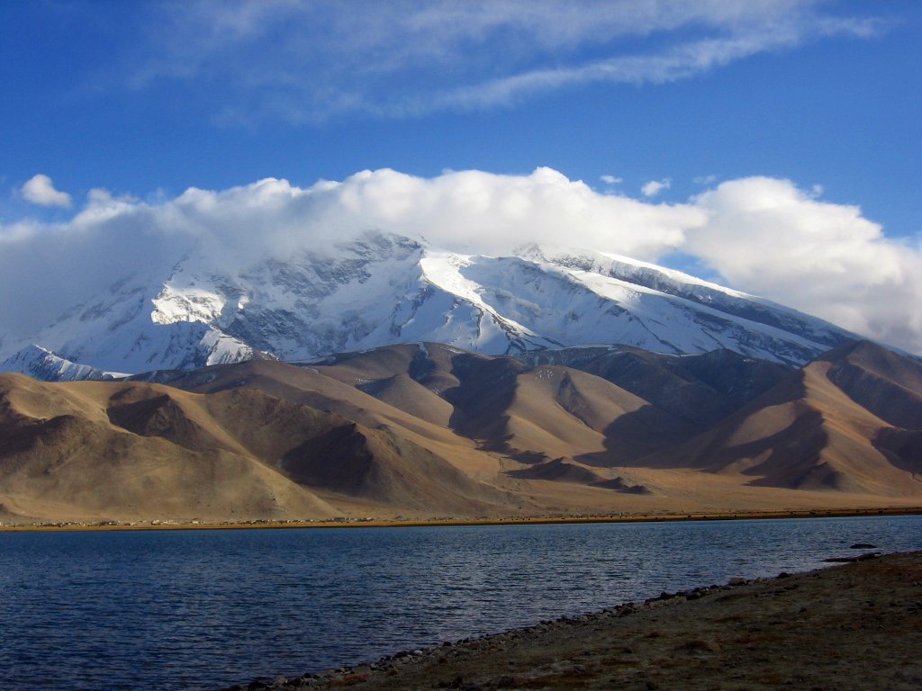
High mountain ranges divide Xinjiang into the Dzungarian Basin (Dzungaria) in the north and the Tarim Basin in the south. Only about 9.7% of Xinjiang's land area is fit for human habitation.[17][unreliable source?] It is home to a number of ethnic groups, including the Han Chinese, Hui, Kazakhs, Kyrgyz, Mongols, Russians, Sibe, Tajiks (Pamiris), Tibetans, and Uyghurs.[18] There are more than a dozen autonomous prefectures and counties for minorities in Xinjiang. Many older English-language reference works call the area Chinese Turkestan,[19][20] Chinese Turkistan,[21] East Turkestan[22] or East Turkistan.[23]
With a documented history of at least 2,500 years, a succession of people and empires have vied for control over all or parts of this territory. In the 18th century it came under the rule of the Qing dynasty, which was later replaced by the Republic of China. Since 1949 and the Chinese Civil War, it has been part of the People's Republic of China. In 1954, the Chinese Communist Party (CCP) established the Xinjiang Production and Construction Corps (XPCC) to strengthen border defense against the Soviet Union and promote the local economy by settling soldiers into the region.[24] In 1955, Xinjiang was administratively changed from a province into an autonomous region. In recent decades, abundant oil and mineral reserves have been found in Xinjiang and it has become China's largest natural-gas-producing region.
From the 1990s to the 2010s, the East Turkestan independence movement, separatist conflict and the influence of radical Islam have resulted in unrest in the region with occasional terrorist attacks and clashes between separatist and government forces.[25][26] These conflicts prompted the Chinese government to commit a series of ongoing human rights abuses against Uyghurs and other ethnic and religious minorities in the region including, according to some, genocide.[27][28]
Names
[edit]| Xinjiang | |||||||||||||||||||||||||||||||||||||||||||||||||
|---|---|---|---|---|---|---|---|---|---|---|---|---|---|---|---|---|---|---|---|---|---|---|---|---|---|---|---|---|---|---|---|---|---|---|---|---|---|---|---|---|---|---|---|---|---|---|---|---|---|
.svg) "Xīnjiāng" in Chinese characters | |||||||||||||||||||||||||||||||||||||||||||||||||
| Chinese name | |||||||||||||||||||||||||||||||||||||||||||||||||
| Chinese | 新疆 | ||||||||||||||||||||||||||||||||||||||||||||||||
| Hanyu Pinyin | Xīnjiāng | ||||||||||||||||||||||||||||||||||||||||||||||||
| Postal | Sinkiang | ||||||||||||||||||||||||||||||||||||||||||||||||
| Literal meaning | "New Frontier" | ||||||||||||||||||||||||||||||||||||||||||||||||
| |||||||||||||||||||||||||||||||||||||||||||||||||
| Xinjiang Uygur Autonomous Region | |||||||||||||||||||||||||||||||||||||||||||||||||
| Simplified Chinese | 新疆维吾尔自治区 | ||||||||||||||||||||||||||||||||||||||||||||||||
| Traditional Chinese | 新疆維吾爾自治區 | ||||||||||||||||||||||||||||||||||||||||||||||||
| Hanyu Pinyin | Xīnjiāng Wéiwú'ěr Zìzhìqū | ||||||||||||||||||||||||||||||||||||||||||||||||
| |||||||||||||||||||||||||||||||||||||||||||||||||
| Mongolian name | |||||||||||||||||||||||||||||||||||||||||||||||||
| Mongolian Cyrillic | Шиньжян Уйгурын өөртөө засах орон | ||||||||||||||||||||||||||||||||||||||||||||||||
| Mongolian script | ᠰᠢᠨᠵᠢᠶᠠᠩ ᠤᠶᠢᠭᠤᠷ ᠤᠨ ᠥᠪᠡᠷᠲᠡᠭᠡᠨ ᠵᠠᠰᠠᠬᠤ ᠣᠷᠤᠨ | ||||||||||||||||||||||||||||||||||||||||||||||||
| |||||||||||||||||||||||||||||||||||||||||||||||||
| Uyghur name | |||||||||||||||||||||||||||||||||||||||||||||||||
| Uyghur | شىنجاڭ ئۇيغۇر ئاپتونوم رايونى | ||||||||||||||||||||||||||||||||||||||||||||||||
| |||||||||||||||||||||||||||||||||||||||||||||||||
| Manchu name | |||||||||||||||||||||||||||||||||||||||||||||||||
| Manchu script | ᡳᠴᡝ ᠵᡝᠴᡝᠨ ᡠᡳᡤᡠᡵ ᠪᡝᠶᡝ ᡩᠠᠰᠠᠩᡤᠠ ᡤᠣᠯᠣ | ||||||||||||||||||||||||||||||||||||||||||||||||
| Möllendorff | Ice Jecen Uigur beye dasangga golo | ||||||||||||||||||||||||||||||||||||||||||||||||
| Kazakh name | |||||||||||||||||||||||||||||||||||||||||||||||||
| Kazakh | شينجياڭ ۇيعۇر اۆتونوميالىق ئاۋدانى Шыңжаң Ұйғыр автономиялық ауданы Shyńjań Uıǵyr aýtonomııalyq aýdany | ||||||||||||||||||||||||||||||||||||||||||||||||
| Kyrgyz name | |||||||||||||||||||||||||||||||||||||||||||||||||
| Kyrgyz | شئنجاڭ ۇيعۇر اپتونوم رايونۇ Шинжаң-Уйгур автоном району Şincañ-Uyğur avtonom rayonu | ||||||||||||||||||||||||||||||||||||||||||||||||
| Oirat name | |||||||||||||||||||||||||||||||||||||||||||||||||
| Oirat | ᠱᡅᠨᡓᡅᡕᠠᡊ ᡇᡕᡅᡎᡇᠷ ᡅᠨ ᡄᡋᡄᠷᡄᡃᠨ ᠴᠠᠰᠠᡍᡇ ᡆᠷᡇᠨ Šinǰiyang Uyiγur-in ebereen zasaqu orun | ||||||||||||||||||||||||||||||||||||||||||||||||
| Xibe name | |||||||||||||||||||||||||||||||||||||||||||||||||
| Xibe | ᠰᡞᠨᡪᠶᠠᡢ ᡠᡞᡤᡠᠷ ᠪᡝᠶᡝ ᡩᠠᠰᠠᡢᡤᠠ ᡤᠣᠯᠣ Sinjyang Uigur beye dasangga golo | ||||||||||||||||||||||||||||||||||||||||||||||||
| Sarikoli name | |||||||||||||||||||||||||||||||||||||||||||||||||
| Sarikoli | شىنجاڭ ئۈيغۈر ئافتۇنۇم رەيۇن Xinjong Üighür Oftunum Rayun[b] | ||||||||||||||||||||||||||||||||||||||||||||||||
The general region of Xinjiang has been known by many different names, including Altishahr—the historical Uyghur name for the southern half of the region referring to "the six cities" of the Tarim Basin—Khotan, Khotay, Chinese Tartary, High Tartary, East Chagatay (it was the eastern part of the Chagatai Khanate), Moghulistan ("land of the Mongols"), Kashgaria, Little Bokhara, Serindia (due to Indian cultural influence)[30] and, in Chinese, Xiyu (西域), meaning "Western Regions".[31]
Between the 2nd century BC and 2nd century AD, the Han Empire established the Protectorate of the Western Regions or Xiyu Protectorate (西域都護府) in an effort to secure the profitable routes of the Silk Road.[32] The Western Regions during the Tang era were known as Qixi (磧西). Qi refers to the Gobi Desert and Xi refers to the west. The Tang Empire established the Protectorate General to Pacify the West or Anxi Protectorate (安西都護府) in 640 to control the region.
During the Qing dynasty, the northern part of Xinjiang, Dzungaria, was known as Zhunbu (準部, "Dzungar region") and the Southern Tarim Basin as Huijiang (回疆, "Muslim Frontier"). Both regions merged after the Qing dynasty suppressed the Revolt of the Altishahr Khojas in 1759, becoming "Xiyu Xinjiang" (西域新疆, literally "Western Regions' New Frontier"), later simplified as "Xinjiang" (新疆; formerly romanized as "Sinkiang"). The official name was given during the reign of the Guangxu Emperor in 1878.[33] It can be translated as "new frontier" or "new territory".[34] In fact, the term "Xinjiang" was used in many other places conquered but never ruled by Chinese empires directly until the gradual Gaitu Guiliu administrative reform, including regions in Southern China.[35] For instance, present-day Jinchuan County in Sichuan was then known as "Jinchuan Xinjiang", Zhaotong in Yunnan was named "Xinjiang", Qiandongnan region, Anshun and Zhenning were named "Liangyou Xinjiang", etc.[36]
In 1955, Xinjiang Province was renamed "Xinjiang Uygur Autonomous Region". The name originally proposed was simply "Xinjiang Autonomous Region" because that was the name of the imperial territory. This proposal was not well received by Uyghurs in the Communist Party, who found the name colonialist since it meant "new territory". Seypidin Azizi, the first chairman of Xinjiang, expressed his strong objection to the proposed name to Mao Zedong, arguing that "autonomy is not given to mountains and rivers. It is given to particular nationalities." Some Uyghur Communists proposed the name "Tian Shan Uyghur Autonomous Region" instead. The Han Communists in the central government denied the name Xinjiang was colonialist or that the central government could be colonialist, both because they were communists and because China was a victim of colonialism. But due to the Uyghur complaints, the administrative region was named "Xinjiang Uygur Autonomous Region".[37][34]
Description
[edit]

Xinjiang consists of two main geographically, historically, and ethnically distinct regions with different historical names, Dzungaria north of the Tianshan Mountains and the Tarim Basin south of the Tianshan Mountains. Qing China unified them into one political entity, Xinjiang Province, in 1884. At the time of the Qing conquest in 1759, Dzungaria was inhabited by steppe-dwelling, nomadic Tibetan Buddhist Dzungar people and the Tarim Basin by sedentary, oasis-dwelling, Turkic-speaking Muslim farmers, now known as the Uyghurs, who were governed separately until 1884.[citation needed]
The Qing dynasty was well aware of the differences between the former Buddhist Mongol area in the north and the Turkic Muslim area in the south, and ruled them in separate administrative units at first.[38] But Qing people began to think of both areas as part of a single region called Xinjiang.[39] The very concept of Xinjiang as a single geographic identity was created by the Qing.[40] During Qing rule, ordinary Xinjiang people had no sense of "regional identity"; rather, Xinjiang's distinct identity was given to the region by the Qing, since it had distinctive geography, history, and culture, while at the same time it was created by the Chinese, multicultural, settled by Han and Hui, and separated from Central Asia for over a century and a half.[41]
In the late 19th century, some people were still proposing that two separate regions be created out of Xinjiang, the area north of the Tianshan and the area south of the Tianshan, while it was being debated whether to make Xinjiang a province.[42]
Xinjiang is a large, sparsely populated area, spanning over 1.6 million km2 (comparable in size to Iran), about a sixth of China's territory. Xinjiang borders the Tibet Autonomous Region and India's Leh district in Ladakh to the south, Qinghai and Gansu provinces to the east, Mongolia (Bayan-Ölgii, Govi-Altai and Khovd Provinces) to the east, Russia's Altai Republic to the north, and Kazakhstan (Almaty and East Kazakhstan Regions), Kyrgyzstan (Issyk-Kul, Naryn and Osh Regions), Tajikistan's Gorno-Badakhshan Autonomous Region, Afghanistan's Badakhshan Province, and Pakistan's Gilgit-Baltistan to the west.
The east–west chain of the Tian Shan separates Dzungaria in the north from the Tarim Basin in the south. Dzungaria is a dry steppe and the Tarim Basin contains the massive Taklamakan Desert, surrounded by oases. In the east is the Turpan Depression. In the west, the Tian Shan split, forming the Ili River valley.
History
[edit]Early history
[edit]| History of Xinjiang |
|---|
 |

The earliest inhabitants of the region encompassing modern day Xinjiang were genetically of Ancient North Eurasian and Northeast Asian origin, with later geneflow from during the Bronze Age linked to the expansion of early Indo-Europeans. These population dynamics gave rise to a heterogeneous demographic makeup. Iron Age samples from Xinjiang show intensified levels of admixture between Steppe pastoralists and northeast Asians, with northern and eastern Xinjiang showing more affinities with northeast Asians, and southern Xinjiang showing more affinity with central Asians.[43][44]
Between 2009 and 2015, the remains of 92 individuals in the Xiaohe Cemetery were analyzed for Y chromosome and mitochondrial DNA markers. Genetic analyses of the mummies showed that the paternal lineages of the Xiaohe people were of almost all European[45] origin, while the maternal lineages of the early population were diverse, featuring both East Eurasian and West Eurasian lineages, as well as a smaller number of Indian / South Asian lineages. Over time, the west Eurasian maternal lineages were gradually replaced by east Eurasian maternal lineages. Outmarriage to women from Siberian communities, led to the loss of the original diversity of mtDNA lineages observed in the earlier Xiaohe population.[46][47][48]
The Tarim population was therefore always notably diverse, reflecting a complex history of admixture between people of Ancient North Eurasian, South Asian and Northeast Asian descent. The Tarim mummies have been found in various locations in the Western Tarim Basin such as Loulan, the Xiaohe Tomb complex and Qäwrighul. These mummies have been previously suggested to have been Tocharian or Indo-European speakers, but recent evidence suggest that the earliest mummies belonged to a distinct population unrelated to Indo-European pastoralists and spoke an unknown language, probably a language isolate.[49]
Although many of the Tarim mummies were classified as Caucasoid by anthropologists, Tarim Basin sites also contain both "Caucasoid" and "Mongoloid" remains, indicating contact between newly arrived western nomads and agricultural communities in the east.[50] Mummies have been found in various locations in the Western Tarim Basin such as Loulan, the Xiaohe Tomb complex and Qäwrighul.
Nomadic tribes such as the Yuezhi, Saka and Wusun were probably part of the migration of Indo-European speakers who had settled in Tarim Basin of Xinjiang long before the Xiongnu and Han Chinese. By the time the Han dynasty under Emperor Wu (r. 141–87 BC) wrested the western Tarim Basin away from its previous overlords (the Xiongnu), it was inhabited by various peoples who included the Indo-European-speaking Tocharians in Turfan and Kucha, the Saka peoples centered in the Shule Kingdom and the Kingdom of Khotan, the various Tibeto-Burmese groups (especially people related to the Qiang) as well as the Han Chinese people.[51] Some linguists posit that the Tocharian language had high amounts of influence from Paleosiberian languages,[52] such as Uralic and Yeniseian languages.
Yuezhi culture is documented in the region. The first known reference to the Yuezhi was in 645 BC by the Chinese chancellor Guan Zhong in his work, Guanzi (管子, Guanzi Essays: 73: 78: 80: 81). He described the Yúshì, 禺氏 (or Niúshì, 牛氏), as a people from the north-west who supplied jade to the Chinese from the nearby mountains (also known as Yushi) in Gansu.[53] The longtime jade supply[54] from the Tarim Basin is well-documented archaeologically: "It is well known that ancient Chinese rulers had a strong attachment to jade. All of the jade items excavated from the tomb of Fuhao of the Shang dynasty, more than 750 pieces, were from Khotan in modern Xinjiang. As early as the mid-first millennium BC, the Yuezhi engaged in the jade trade, of which the major consumers were the rulers of agricultural China."[55]
Crossed by the Northern Silk Road,[56] the Tarim and Dzungaria regions were known as the Western Regions. At the beginning of the Han dynasty the region was ruled by the Xiongnu, a powerful nomadic people.[57]: 148 During the 2nd century BC, the Han dynasty prepared for war against Xiongnu when Emperor Wu of Han dispatched Zhang Qian to explore the mysterious kingdoms to the west and form an alliance with the Yuezhi against the Xiongnu. As a result of the war, the Chinese controlled the strategic region from the Ordos and Gansu corridor to Lop Nor. They separated the Xiongnu from the Qiang people on the south and gained direct access to the Western Regions. Han China sent Zhang Qian as an envoy to the states of the region, beginning several decades of struggle between the Xiongnu and Han China in which China eventually prevailed. During the 100s BCE, the Silk Road brought increasing Chinese economic and cultural influence to the region.[57]: 148 In 60 BCE, Han China established the Protectorate of the Western Regions (西域都護府) at Wulei (烏壘, near modern Luntai), to oversee the region as far west as the Pamir Mountains. The protectorate was seized during the civil war against Wang Mang (r. AD 9–23), returning to Han control in 91 due to the efforts of general Ban Chao.


The Western Jin dynasty succumbed to successive waves of invasions by nomads from the north at the beginning of the 4th century. The short-lived kingdoms that ruled northwestern China one after the other, including Former Liang, Former Qin, Later Liang and Western Liáng, all attempted to maintain the protectorate, with varying degrees of success. After the final reunification of Northern China under the Northern Wei empire, its protectorate controlled what is now the southeastern region of Xinjiang. Local states such as Shule, Yutian, Guizi and Qiemo controlled the western region, while the central region around Turpan was controlled by Gaochang, remnants of a state (Northern Liang) that once ruled part of what is now Gansu province in northwestern China.

During the Tang dynasty, a series of expeditions were conducted against the Western Turkic Khaganate and their vassals: the oasis states of southern Xinjiang.[58] Campaigns against the oasis states began under Emperor Taizong with the annexation of Gaochang in 640.[59] The nearby kingdom of Karasahr was captured by the Tang in 644 and the kingdom of Kucha was conquered in 649.[60] The Tang Dynasty then established the Protectorate General to Pacify the West (安西都護府) or Anxi Protectorate, in 640 to control the region.
During the Anshi Rebellion, which nearly destroyed the Tang dynasty, Tibet invaded the Tang on a broad front from Xinjiang to Yunnan. It occupied the Tang capital of Chang'an in 763 for 16 days, and controlled southern Xinjiang by the end of the century. The Uyghur Khaganate took control of Northern Xinjiang, much of Central Asia and Mongolia at the same time.
As Tibet and the Uyghur Khaganate declined in the mid-9th century, the Kara-Khanid Khanate (a confederation of Turkic tribes including the Karluks, Chigils and Yaghmas)[61] controlled Western Xinjiang during the 10th and 11th centuries. After the Uyghur Khaganate in Mongolia was destroyed by the Kirghiz in 840, branches of the Uyghurs established themselves in Qocha (Karakhoja) and Beshbalik (near present-day Turfan and Ürümqi). The Uyghur state remained in eastern Xinjiang until the 13th century, although it was ruled by foreign overlords. The Kara-Khanids converted to Islam. The Uyghur state in Eastern Xinjiang, initially Manichean, later converted to Buddhism.
Remnants of the Liao dynasty from Manchuria entered Xinjiang in 1132, fleeing rebellion by the neighboring Jurchens. They established a new empire, the Qara Khitai (Western Liao), which ruled the Kara-Khanid and Uyghur-held parts of the Tarim Basin for the next century. Although Khitan and Chinese were the primary administrative languages, Persian and Uyghur were also used.[62]
Islamization
[edit]| Part of a series on Islam in China |
|---|
 |
|
|
Present-day Xinjiang consisted of the Tarim Basin and Dzungaria and was originally inhabited by Indo-European Tocharians and Iranian Sakas who practiced Buddhism and Zoroastrianism. The Turfan and Tarim Basins were inhabited by speakers of Tocharian languages,[63] with Caucasian mummies found in the region.[64] The area became Islamified during the 10th century with the conversion of the Kara-Khanid Khanate, who occupied Kashgar. During the mid-10th century, the Saka Buddhist Kingdom of Khotan was attacked by the Turkic Muslim Karakhanid ruler Musa; the Karakhanid leader Yusuf Qadir Khan conquered Khotan around 1006.[65]
Mongol period
[edit]
After Genghis Khan unified Mongolia and began his advance west the Uyghur state in the Turpan-Urumchi region offered its allegiance to the Mongols in 1209, contributing taxes and troops to the Mongol imperial effort. In return, the Uyghur rulers retained control of their kingdom; Genghis Khan's Mongol Empire conquered the Qara Khitai in 1218. Xinjiang was a stronghold of Ögedei Khan and later came under the control of his descendant, Kaidu. This branch of the Mongol family kept the Yuan dynasty at bay until their rule ended.
During the Mongol Empire era the Yuan dynasty vied with the Chagatai Khanate for rule of the region and the latter controlled most of it. After the Chagatai Khanate divided into smaller khanates during the mid-14th century, the politically fractured region was ruled by a number of Persianized Mongol Khans, including those from Moghulistan (with the assistance of local Dughlat emirs), Uigurstan (later Turpan) and Kashgaria. These leaders warred with each other and the Timurids of Transoxiana to the west and the Oirats to the east: the successor Chagatai regime based in Mongolia and China. During the 17th century, the Dzungars established an empire over much of the region.
The Mongolian Dzungars were the collective identity of several Oirat tribes which formed and maintained, one of the last nomadic empires. The Dzungar Khanate covered Dzungaria, extending from the western Great Wall of China to present-day Eastern Kazakhstan and from present-day Northern Kyrgyzstan to Southern Siberia. Most of the region was renamed "Xinjiang" by the Chinese after the fall of the Dzungar Empire, which existed from the early 17th to the mid-18th century.[66]

The sedentary Turkic Muslims of the Tarim Basin were originally ruled by the Chagatai Khanate and the nomadic Buddhist Oirat Mongols in Dzungaria ruled the Dzungar Khanate. The Naqshbandi Sufi Khojas, descendants of Muhammad, had replaced the Chagatayid Khans as rulers of the Tarim Basin during the early 17th century. There was a struggle between two Khoja factions: the Afaqi (White Mountain) and the Ishaqi (Black Mountain). The Ishaqi defeated the Afaqi and the Afaq Khoja invited the 5th Dalai Lama (the leader of the Tibetans) to intervene on his behalf in 1677. The Dalai Lama then called on his Dzungar Buddhist followers in the Dzungar Khanate to act on the invitation. The Dzungar Khanate conquered the Tarim Basin in 1680, setting up the Afaqi Khoja as their puppet ruler. After converting to Islam, the descendants of the previously-Buddhist Uyghurs in Turfan believed that the "infidel Kalmuks" (Dzungars) built Buddhist monuments in their region.[67]
Qing dynasty
[edit]


The Turkic Muslims of the Turfan and Kumul oases then submitted to the Qing dynasty and asked China to free them from the Dzungars; the Qing accepted their rulers as vassals. They warred against the Dzungars for decades before defeating them; Qing Manchu Bannermen then conducted the Dzungar genocide, nearly eradicating them and depopulating Dzungaria. The Qing freed the Afaqi Khoja leader Burhan-ud-din and his brother, Khoja Jihan, from Dzungar imprisonment and appointed them to rule the Tarim Basin as Qing vassals. The Khoja brothers reneged on the agreement, declaring themselves independent leaders of the Tarim Basin. The Qing and the Turfan leader Emin Khoja crushed their revolt, and by 1759 China controlled Dzungaria and the Tarim Basin.[68]
The Manchu Qing dynasty gained control of eastern Xinjiang as a result of a long struggle with the Dzungars which began during the 17th century. In 1755, with the help of the Oirat noble Amursana, the Qing attacked Ghulja and captured the Dzungar khan. After Amursana's request to be declared Dzungar khan went unanswered, he led a revolt against the Qing. Qing armies destroyed the remnants of the Dzungar Khanate over the next two years, and many Han Chinese and Hui moved into the pacified areas.[69]
The native Dzungar Oirat Mongols suffered greatly from the brutal campaigns and a simultaneous smallpox epidemic. Writer Wei Yuan described the resulting desolation in present-day northern Xinjiang as "an empty plain for several thousand li, with no Oirat yurt except those surrendered."[70] It has been estimated that 80 percent of the 600,000 (or more) Dzungars died from a combination of disease and warfare,[71] and recovery took generations.[72]
Han and Hui merchants were initially only allowed to trade in the Tarim Basin; their settlement in the Tarim Basin was banned until the 1830 Muhammad Yusuf Khoja invasion, when the Qing rewarded merchants for fighting off Khoja by allowing them to settle in the basin.[73] The Uyghur Muslim Sayyid and Naqshbandi Sufi rebel of the Afaqi suborder, Jahangir Khoja was sliced to death (Lingchi) in 1828 by the Manchus for leading a rebellion against the Qing. According to Robert Montgomery Martin, many Chinese with a variety of occupations were settled in Dzungaria in 1870; in Turkestan (the Tarim Basin), however, only a few Chinese merchants and garrison soldiers were interspersed with the Muslim population.[74]
The 1765 Ush rebellion by the Uyghurs against the Manchu began after Uyghur women were raped by the servants and son of Manchu official Su-cheng.[75] It was said that "Ush Muslims had long wanted to sleep on [Sucheng and son's] hides and eat their flesh" because of the months-long abuse.[76] The Manchu emperor ordered the massacre of the Uyghur rebel town; Qing forces enslaved the Uyghur children and women, and killed the Uyghur men.[77] Sexual abuse of Uyghur women by Manchu soldiers and officials triggered deep Uyghur hostility against Manchu rule.[78]
Yettishar
[edit]
By the 1860s, Xinjiang had been under Qing rule for a century. The region was captured in 1759 from the Dzungar Khanate,[79] whose population (the Oirats) became the targets of genocide. Xinjiang was primarily semi-arid or desert and unattractive to non-trading Han settlers, and others (including the Uyghurs) settled there.[citation needed]
The Dungan Revolt by the Muslim Hui and other Muslim ethnic groups was fought in China's Shaanxi, Ningxia and Gansu provinces and in Xinjiang from 1862 to 1877. The conflict led to a reported 20.77 million deaths due to migration and war, with many refugees dying of starvation.[80][failed verification] Thousands of Muslim refugees from Shaanxi fled to Gansu; some formed battalions in eastern Gansu, intending to reconquer their lands in Shaanxi. While the Hui rebels were preparing to attack Gansu and Shaanxi, Yakub Beg (an Uzbek or Tajik commander of the Kokand Khanate) fled from the khanate in 1865 after losing Tashkent to the Russians. Beg settled in Kashgar, and soon controlled Xinjiang. Although he encouraged trade, built caravansareis, canals and other irrigation systems, his regime was considered harsh. The Chinese took decisive action against Yettishar; an army under General Zuo Zongtang rapidly approached Kashgaria, reconquering it on 16 May 1877.[81]

After reconquering Xinjiang in the late 1870s from Yakub Beg,[82] the Qing dynasty established Xinjiang ("new frontier") as a province in 1884[83] – making it part of China, and dropping the old names of Zhunbu (準部, Dzungar Region) and Huijiang (Muslimland).[84][85] Many Uyghurs subsequently migrated from southern Xinjiang to the fertile lands of the north and east, sometimes with the support of the Qing government.[86]
Republic of China
[edit]
In 1912, the Qing dynasty was replaced by the Republic of China. The ROC continued to treat the Qing territory as its own, including Xinjiang.[87]: 69 Yuan Dahua, the last Qing governor of Xinjiang, fled. One of his subordinates, Yang Zengxin, took control of the province and acceded in name to the Republic of China in March of that year. Balancing mixed ethnic constituencies, Yang controlled Xinjiang until his 1928 assassination after the Northern Expedition of the Kuomintang.[88]

The Kumul Rebellion and others broke out throughout Xinjiang during the early 1930s against Jin Shuren, Yang's successor, involving Uyghurs, other Turkic groups and Hui (Muslim) Chinese. Jin enlisted White Russians to crush the revolts. In the Kashgar region on 12 November 1933, the short-lived First East Turkestan Republic was self-proclaimed after debate about whether it should be called "East Turkestan" or "Uyghuristan".[89][90] The region claimed by the ETR encompassed the Kashgar, Khotan and Aksu Prefectures in southwestern Xinjiang.[91] The Chinese Muslim Kuomintang 36th Division (National Revolutionary Army) defeated the army of the First East Turkestan Republic in the 1934 Battle of Kashgar, ending the republic after Chinese Muslims executed its two emirs: Abdullah Bughra and Nur Ahmad Jan Bughra.
Soviet partial occupation
[edit]The Soviet Union invaded the province; it was brought under the control of northeast Han warlord Sheng Shicai after the 1937 Xinjiang War. Sheng ruled Xinjiang for the next decade with support from the Soviet Union, many of whose ethnic and security policies he instituted. The Soviet Union maintained a military base in the province and deployed several military and economic advisors. Sheng invited a group of Chinese Communists to Xinjiang (including Mao Zedong's brother, Mao Zemin),[92]: 111 but executed them all in 1943 in fear of a conspiracy. In 1944, President and Premier of China Chiang Kai-shek, informed by the Soviet Union of Shicai's intention to join it, transferred him to Chongqing as the Minister of Agriculture and Forestry the following year.[93] During the Ili Rebellion, the Soviet Union backed Uyghur separatists to form the Second East Turkestan Republic (ETR) in the Ili region while most of Xinjiang remained under Kuomintang control.[89]
People's Republic of China
[edit].png)
The People's Liberation Army entered Xinjiang in 1949, when Kuomintang commander Tao Zhiyue and government chairman Burhan Shahidi surrendered the province to them.[90] Five ETR leaders who were to negotiate with the Chinese about ETR sovereignty died in an airplane crash that year in the outskirts of Kabansk in the Russian SFSR.[94] The PRC continued the migration of Han Chinese in Xinjiang to dilute the percentage of the Uyghur population.[95]
The PRC autonomous region was established on 1 October 1955, replacing the province;[90] that year (the first modern census in China was taken in 1953), Uyghurs were 73 percent of Xinjiang's total population of 5.11 million.[37] Although Xinjiang has been designated a "Uygur Autonomous Region" since 1954, more than 50 percent of its area is designated autonomous areas for 13 native non-Uyghur groups.[96] Modern Uyghurs developed ethnogenesis in 1955, when the PRC recognized formerly separately self-identified oasis peoples.[97]
Southern Xinjiang is home to most of the Uyghur population, about nine million people, out of a total population of twenty million; fifty-five percent of Xinjiang's Han population, mainly urban, live in the north.[98][99] This created an economic imbalance, since the northern Junghar basin (Dzungaria) is more developed than the south.[100]
Land reform and collectivization occurred in Uyghur agricultural areas at the same general pace as in most of China.[101]: 134 Hunger in Xinjiang was not as great as elsewhere in China during the Great Leap Forward and a million Han Chinese fleeing famine resettled in Xinjiang.[101]: 134
In 1980, China allowed the United States to establish electronic listening stations in Xinjiang so the United States could monitor Soviet rocket launches in central Asia in exchange for the United States authorizing the sale of dual-use civilian and military technology and nonlethal military equipment to China.[102]
The Chinese economic reform since the late 1970s has exacerbated uneven regional development, more Uyghurs have migrated to Xinjiang's cities and some Han have migrated to Xinjiang for economic advancement. Chinese leader Deng Xiaoping made a nine-day visit to Xinjiang in 1981 and described the region as "unsteady".[103] The Deng era reforms encouraged China's ethnic minorities, including Uyghurs, to establish small private companies for commodity transit, retail, and restaurants.[104] By the early 1990s, a total of 19 billion yuan had been spent in Xinjiang on large- and medium-sized industrial projects, with an emphasis on developing modern transportation, communications infrastructure, and support for the oil and gas industries.[57]: 149
A brisk cross-border shuttle trade by Uyghurs further developed following the adoption of the Soviet Union's perestroika.[104]
Increased ethnic contact and labor competition has coincided with Uyghur terrorism since the 1990s, such as the 1997 Ürümqi bus bombings.[105]
In 2000, Uyghurs made up 45 percent of Xinjiang's population and 13 percent of Ürümqi's population. With nine percent of Xinjiang's population, Ürümqi accounts for 25 percent of the region's GDP; many rural Uyghurs have migrated to the city for work in its light, heavy and petrochemical industries.[106] Han in Xinjiang are older, better-educated and work in higher-paying professions than their Uyghur counterparts. Han are more likely to cite business reasons for moving to Ürümqi, while some Uyghurs cite legal trouble at home and family reasons for moving to the city.[107] Han and Uyghurs are equally represented in Ürümqi's floating population, which works primarily in commerce. Auto-segregation in the city is widespread in residential concentration, employment relationships and endogamy.[108] In 2010, Uyghurs were a majority in the Tarim Basin and a plurality in Xinjiang as a whole.[109]
Xinjiang has 81 public libraries and 23 museums, compared to none in 1949. It has 98 newspapers in 44 languages, compared with four in 1952. According to official statistics, the ratio of doctors, medical workers, clinics and hospital beds to the general population surpasses the national average; the immunization rate has reached 85 percent.[5]
The ongoing Xinjiang conflict[110][111] includes the 2007 Xinjiang raid,[112] a thwarted 2008 suicide-bombing attempt on a China Southern Airlines flight,[113] the 2008 Kashgar attack which killed 16 police officers four days before the Beijing Olympics,[114][115] the August 2009 syringe attacks,[116] the 2011 Hotan attack,[117] the 2014 Kunming attack,[118] the April 2014 Ürümqi attack,[119] and the May 2014 Ürümqi attack.[120] Several of the attacks were orchestrated by the Turkistan Islamic Party (formerly the East Turkestan Islamic Movement), identified as a terrorist group by several entities (including Russia,[121] Turkey,[122][123] the United Kingdom,[124] the United States until October 2020,[125][126] and the United Nations).[127]
In 2014, Chinese Communist Party (CCP) leadership in Xinjiang commenced a People's War against the "Three Evil Forces" of separatism, terrorism, and extremism. They deployed two hundred thousand party cadres to Xinjiang and the launched the Civil Servant-Family Pair Up program.[128][129] Chinese Communist Party leader Xi Jinping was dissatisfied with the initial results of the People's War and replaced Zhang Chunxian with Chen Quanguo as Party Committee Secretary in 2016. Following his appointment Chen oversaw the recruitment of tens of thousands of additional police officers and the division of society into three categories: trusted, average, untrustworthy. He instructed his subordinated to "Take this crackdown as the top project," and "to preëmpt the enemy, to strike at the outset." Following a meeting with Xi in Beijing Chen Quanguo held a rally in Ürümqi with ten thousand troops, helicopters, and armored vehicles. As they paraded he announced a "smashing, obliterating offensive," and declared that they would "bury the corpses of terrorists and terror gangs in the vast sea of the People's War."[128]
Chinese authorities have operated internment camps to indoctrinate Uyghurs and other Muslims as part of the People's War since at least 2017.[130][27] The camps have been criticized by a number of governments and human-rights organizations for patterns of abuse and mistreatment, with various characterizations up to and including that of a genocide being perpetrated by the Chinese government.[131] In 2020, CCP General Secretary Xi Jinping said: "Practice has proven that the party's strategy for governing Xinjiang in the new era is completely correct."[132]
In 2021, authorities sentenced Sattar Sawut and Shirzat Bawudun—former heads of Xinjiang's education and justice departments respectively—both to death with a two-year reprieve on separatism and bribery charges.[133] Such a sentence is usually commuted to life imprisonment.[134] Officials said Sawut was found guilty of incorporating ethnic separatism, violence, and religious extremism content into Uyghur-language textbooks, which had influenced several people to participate in attacks in Ürümqi. They said Bawudun was found guilty of colluding with ETIM and carrying out "illegal religious activities at his daughter's wedding".[133][135] Three other educators were sentenced to life in prison.[136] Chen was replaced as Community Party Secretary for Xinjiang by Ma Xingrui in December 2021.[137]
Xi Jinping made a four-day visit to Xinjiang in July 2022 where Kompas TV had documented groups of Uyghurs welcoming his arrival.[138] Xi called on local officials to do more in preserving ethnic minority culture[139] and following an inspection of the Xinjiang Production and Construction Corps, he praised the organization's "great progress" in reform and development.[140] During another visit to Xinjiang in August 2023, Xi said in a speech that the region should open up more for tourism to attract domestic and foreign visitors.[141][142]
Administrative divisions
[edit]Xinjiang is divided into thirteen prefecture-level divisions: four prefecture-level cities, six prefectures and five autonomous prefectures (including the sub-provincial autonomous prefecture of Ili, which in turn has two of the seven prefectures within its jurisdiction) for Mongol, Kazakh, Kyrgyz and Hui minorities.[143]
These are then divided into 13 districts, 29 county-level cities, 62 counties and 6 autonomous counties. Twelve of the county-level cities do not belong to any prefecture and are de facto administered by the Xinjiang Production and Construction Corps (XPCC). Sub-level divisions of the Xinjiang Uygur Autonomous Region is shown in the adjacent picture and described in the table below:
| Administrative divisions of Xinjiang | |||||||||||||
|---|---|---|---|---|---|---|---|---|---|---|---|---|---|

█ XPCC / Bingtuan administered
county-level divisions █ Subordinate to Ili Kazakh A.P.
☐ Disputed areas claimed by India
and administered by China (see Sino-Indian border dispute) | |||||||||||||
| Division code[144] | Division | Area in km2[145] | Population 2020[146][147] | Seat | Divisions[148] | ||||||||
| Districts | Counties | Aut. counties | CL cities | ||||||||||
| 650000 | Xinjiang Uygur Autonomous Region | 1,664,900.00 | 25,852,345 | Ürümqi city | 13 | 62 | 6 | 29 | |||||
| 650100 | Ürümqi city | 13,787.90 | 4,054,369 | Tianshan District | 7 | 1 | |||||||
| 650200 | Karamay city | 8,654.08 | 490,348 | Karamay District | 4 | ||||||||
| 650400 | Turpan city | 67,562.91 | 693,988 | Gaochang District | 1 | 2 | |||||||
| 650500 | Hami city | 142,094.88 | 673,383 | Yizhou District | 1 | 1 | 1 | ||||||
| 652300 | Changji Hui Autonomous Prefecture | 73,139.75 | 1,613,585 | Changji city | 4 | 1 | 2 | ||||||
| 652700 | Bortala Mongol Autonomous Prefecture | 24,934.33 | 488,198 | Bole city | 2 | 2 | |||||||
| 652800 | Bayingolin Mongol Autonomous Prefecture | 470,954.25 | 1,613,979 | Korla city | 7 | 1 | 1 | ||||||
| 652900 | Aksu Prefecture | 127,144.91 | 2,714,422 | Aksu city | 7 | 2 | |||||||
| 653000 | Kizilsu Kyrgyz Autonomous Prefecture | 72,468.08 | 622,222 | Artux city | 3 | 1 | |||||||
| 653100 | Kashgar Prefecture | 137,578.51 | 4,496,377 | Kashi city | 10 | 1 | 1 | ||||||
| 653200 | Hotan Prefecture | 249,146.59 | 2,504,718 | Hotan city | 9 | 1 | |||||||
| 654000 | Ili Kazakh Autonomous Prefecture | 56,381.53 * | 2,848,393 * | Yining city | 7 * | 1 * | 3 * | ||||||
| 654200 | Tacheng Prefecture* | 94,698.18 | 1,138,638 | Tacheng city | 4 | 1 | 3 | ||||||
| 654300 | Altay Prefecture* | 117,699.01 | 668,587 | Altay city | 6 | 1 | |||||||
| 659000 | Xinjiang Production and Construction Corps | 13,055.57 | 1,573,931 | Ürümqi city | 12 | ||||||||
| 659001 | Shihezi city (8th Division) | 456.84 | 498,587 | Hongshan Subdistrict | 1 | ||||||||
| 659002 | Aral city (1st Division) | 5,266.00 | 328,241 | Jinyinchuan Road Subdistrict | 1 | ||||||||
| 659003 | Tumxuk city (3rd Division) | 2,003.00 | 263,245 | Jinxiu Subdistrict | 1 | ||||||||
| 659004 | Wujiaqu city (6th Division) | 742.00 | 141,065 | Renmin Road Subdistrict | 1 | ||||||||
| 659005 | Beitun city (10th Division) | 910.50 | 20,414 | Beitun Town (Altay) | 1 | ||||||||
| 659006 | Tiemenguan city (2nd Division) | 590.27 | 104,746 | Xingjiang Road, 29th Regiment | 1 | ||||||||
| 659007 | Shuanghe city (5th Division) | 742.18 | 54,731 | Hongxing No.2 Road, 89th Regiment | 1 | ||||||||
| 659008 | Kokdala city (4th Division) | 979.71 | 69,524 | Xinfu Road, 66th Regiment | 1 | ||||||||
| 659009 | Kunyu city (14th Division) | 687.13 | 63,487 | Yuyuan Town | 1 | ||||||||
| 659010 | Huyanghe city (7th Division) | 677.94 | 29,891 | Gongqing town | 1 | ||||||||
| 659011 | Xinxing city (13th Division) | 593.00 | 44,700 | Huangtian Town | 1 | ||||||||
| 659012 | Baiyang city (9th Division) | 4,928.00 | 85,655 | 163rd Regiment of the 9th Division | 1 | ||||||||
|
* – Altay Prefecture or Tacheng Prefecture are subordinate to Ili Prefecture. / The population or area figures of Ili do not include Altay Prefecture or Tacheng Prefecture which are subordinate to Ili Prefecture. | |||||||||||||
| Administrative divisions in Uyghur, Chinese and varieties of romanizations | ||||
|---|---|---|---|---|
| English | Uyghur | SASM / GNC Uyghur Pinyin | Chinese | Pinyin |
| Xinjiang Uygur Autonomous Region | شىنجاڭ ئۇيغۇر ئاپتونوم رايونى | Xinjang Uyĝur Aptonom Rayoni | 新疆维吾尔自治区 | Xīnjiāng Wéiwú'ěr Zìzhìqū |
| Ürümqi city | ئۈرۈمچى شەھىرى | Ürümqi Xäĥiri | 乌鲁木齐市 | Wūlǔmùqí Shì |
| Karamay city | قاراماي شەھىرى | K̂aramay Xäĥiri | 克拉玛依市 | Kèlāmǎyī Shì |
| Turpan city | تۇرپان شەھىرى | Turpan Xäĥiri | 吐鲁番市 | Tǔlǔfān Shì |
| Hami city | قۇمۇل شەھىرى | K̂umul Xäĥiri | 哈密市 | Hāmì Shì |
| Changji Hui Autonomous Prefecture | سانجى خۇيزۇ ئاپتونوم ئوبلاستى | Sanji Huyzu Aptonom Oblasti | 昌吉回族自治州 | Chāngjí Huízú Zìzhìzhōu |
| Bortala Mongol Autonomous Prefecture | بۆرتالا موڭغۇل ئاپتونوم ئوبلاستى | Börtala Mongĝul Aptonom Oblasti | 博尔塔拉蒙古自治州 | Bó'ěrtǎlā Měnggǔ Zìzhìzhōu |
| Bayingolin Mongol Autonomous Prefecture | بايىنغولىن موڭغۇل ئاپتونوم ئوبلاستى | Bayinĝolin Mongĝul Aptonom Oblasti | 巴音郭楞蒙古自治州 | Bāyīnguōlèng Měnggǔ Zìzhìzhōu |
| Aksu Prefecture | ئاقسۇ ۋىلايىتى | Ak̂su Vilayiti | 阿克苏地区 | Ākèsū Dìqū |
| Kizilsu Kirghiz Autonomous Prefecture | قىزىلسۇ قىرغىز ئاپتونوم ئوبلاستى | K̂izilsu K̂irĝiz Aptonom Oblasti | 克孜勒苏柯尔克孜自治州 | Kèzīlèsū Kē'ěrkèzī Zìzhìzhōu |
| Kashi Prefecture | قەشقەر ۋىلايىتى | K̂äxk̂är Vilayiti | 喀什地区 | Kāshí Dìqū |
| Hotan Prefecture | خوتەن ۋىلايىتى | Hotän Vilayiti | 和田地区 | Hétián Dìqū |
| Ili Kazakh Autonomous Prefecture | ئىلى قازاق ئاپتونوم ئوبلاستى | Ili K̂azak̂ Aptonom Oblasti | 伊犁哈萨克自治州 | Yīlí Hāsàkè Zìzhìzhōu |
| Tacheng Prefecture | تارباغاتاي ۋىلايىتى | Tarbaĝatay Vilayiti | 塔城地区 | Tǎchéng Dìqū |
| Altay Prefecture | ئالتاي ۋىلايىتى | Altay Vilayiti | 阿勒泰地区 | Ālètài Dìqū |
| Shihezi city | شىخەنزە شەھىرى | Xihänzä Xäĥiri | 石河子市 | Shíhézǐ Shì |
| Aral city | ئارال شەھىرى | Aral Xäĥiri | 阿拉尔市 | Ālā'ěr Shì |
| Tumxuk city | تۇمشۇق شەھىرى | Tumxuk̂ Xäĥiri | 图木舒克市 | Túmùshūkè Shì |
| Wujiaqu city | ۋۇجياچۈ شەھىرى | Vujyaqü Xäĥiri | 五家渠市 | Wǔjiāqú Shì |
| Beitun city | بەيتۈن شەھىرى | Bäatün Xäĥiri | 北屯市 | Běitún Shì |
| Tiemenguan city | باشئەگىم شەھىرى | Baxägym Xäĥiri | 铁门关市 | Tiĕménguān Shì |
| Shuanghe city | قوشئۆگۈز شەھىرى | K̂oxögüz Xäĥiri | 双河市 | Shuānghé Shì |
| Kokdala city | كۆكدالا شەھىرى | Kökdala Xäĥiri | 可克达拉市 | Kěkèdálā Shì |
| Kunyu city | قۇرۇمقاش شەھىرى | Kurumkax XCĥiri | 昆玉市 | Kūnyù Shì |
| Huyanghe city | خۇياڭخې شەھىرى | Huyanghê Xäĥiri | 胡杨河市 | Húyánghé Shì |
| Xinxing city | يېڭى يۇلتۇز شەھىرى | Yëngi Yultuz Xäĥiri | 新星市 | Xīnxīng Shì |
| Baiyang city | بەيياڭ شەھىرى | Bäyyang Xäĥiri | 白杨市 | BaíYáng Shì |
Urban areas
[edit]| Population by urban areas of prefecture & county cities | ||||
|---|---|---|---|---|
| # | Cities | 2020 Urban area[149] | 2010 Urban area[150] | 2020 City proper |
| 1 | Ürümqi | 3,864,136 | 2,853,398 | 4,054,369 |
| 2 | Yining | 654,726 | 368,813 | part of Ili Prefecture |
| 3 | Korla | 490,961 | 425,182 | part of Bayingolin Prefecture |
| 4 | Karamay | 481,249 | 353,299 | 490,348 |
| 5 | Aksu | 470,601 | 284,872 | part of Aksu Prefecture |
| 6 | Shihezi | 461,663 | 313,768 | 498,587 |
| 7 | Changji | 451,234 | 303,938 | part of Changji Prefecture |
| 8 | Hami | 426,072 | 310,500[i] | 673,383 |
| 9 | Kashi | 392,730 | 310,448 | part of Kashi Prefecture |
| 10 | Hotan | 293,056 | 119,804 | part of Hotan Prefecture |
| 11 | Kuqa | 262,771 | [ii] | part of Aksu Prefecture |
| 12 | Aral | 239,647 | 65,175 | 328,241 |
| 13 | Kuytun | 224,471 | 20,805 | part of Ili Prefecture |
| 14 | Bole | 177,536 | 120,138 | part of Bortala Prefecture |
| 15 | Usu | 156,437 | 131,661 | part of Tacheng Prefecture |
| (16) | Shawan | 150,317[iii] | part of Tacheng Prefecture | |
| 17 | Altay | 147,301 | 112,711 | part of Altay Prefecture |
| 18 | Turpan | 143,456 | 89,719[iv] | 693,988 |
| 19 | Tumxuk | 128,056 | 34,808 | 263,245 |
| 20 | Fukang | 125,080 | 67,598 | part of Changji Prefecture |
| 21 | Tacheng | 122,447 | 75,122 | part of Tacheng Prefecture |
| 22 | Wujiaqu | 118,893 | 75,088 | 141,065 |
| 23 | Artux | 105,855 | 58,427 | part of Kizilsu Prefecture |
| (24) | Baiyang | 85,655[v] | 85,655 | |
| 25 | Tiemenguan | 77,969 | [vi] | 104,746 |
| 26 | Korgas | 44,701 | [vii] | part of Ili Prefecture |
| (27) | Xinxing | 44,700[viii] | 44,700 | |
| 28 | Shuanghe | 43,263 | [ix] | 54,731 |
| 29 | Kokdala | 39,257 | [x] | 69,524 |
| 30 | Kunyu | 32,591 | [xi] | 63,487 |
| 32 | Huyanghe | 24,769 | [xii] | 29,891 |
| 32 | Beitun | 13,874 | [xiii] | 20,414 |
| 33 | Alashankou | 11,097 | [xiv] | part of Bortala Prefecture |
- ^ Hami Prefecture is currently known as Hami PLC after 2010 census; Hami CLC is currently known as Yizhou after 2010 census.
- ^ Kuqa County is currently known as Kuqa CLC after 2010 census.
- ^ Shawan County is currently known as Shawan CLC after 2020 census.
- ^ Turpan Prefecture is currently known as Turpan PLC after 2010 census; Turpan CLC is currently known as Gaochang after 2010 census.
- ^ Baiyang CLC was established from parts of Tachang CLC after 2020 census.
- ^ Tiemenguan CLC was established from parts of Korla CLC after 2010 census.
- ^ Korgas CLC was established from parts of Huocheng County after 2010 census.
- ^ Xinxing CLC was established from parts of Yizhou District after 2020 census.
- ^ Shuanghe CLC was established from parts of Bole CLC after 2010 census.
- ^ Kokdala CLC was established from parts of Huocheng County after 2010 census.
- ^ Kunyu CLC was established from parts of Hotan County, Pishan County, Moyu County, & Qira County after 2010 census.
- ^ Huyanghe CLC was established from parts of Usu CLC after 2010 census.
- ^ Beitun CLC was established from parts of Altay CLC after 2010 census.
- ^ Alashankou CLC was established from parts of Bole CLC & Jinghe County after 2010 census.
Geography and geology
[edit]
Xinjiang is the largest political subdivision of China, accounting for more than one sixth of China's total territory and a quarter of its boundary length. Xinjiang is mostly covered with uninhabitable deserts and dry grasslands, with dotted oases conducive to habitation accounting for 9.7 percent of Xinjiang's total area by 2015[17] at the foot of Tian Shan, Kunlun Mountains and Altai Mountains, respectively.
Mountain systems and basins
[edit]Xinjiang is split by the Tian Shan mountain range (تەڭرى تاغ, Tengri Tagh, Тәңри Тағ), which divides it into two large basins: the Dzungarian Basin in the north and the Tarim Basin in the south. A small V-shaped wedge between these two major basins, limited by the Tian Shan's main range in the south and the Borohoro Mountains in the north, is the basin of the Ili River, which flows into Kazakhstan's Lake Balkhash; an even smaller wedge farther north is the Emin Valley.

Other major mountain ranges of Xinjiang include the Pamir Mountains and Karakoram in the southwest, the Kunlun Mountains in the south (along the border with Tibet) and the Altai Mountains in the northeast (shared with Mongolia). The region's highest point is the mountain K2, an eight-thousander located 8,611 metres (28,251 ft) above sea level in the Karakoram Mountains on the border with Pakistan.

Much of the Tarim Basin is dominated by the Taklamakan Desert. North of it is the Turpan Depression, which contains the lowest point in Xinjiang and in the entire PRC, at 155 metres (509 ft) below sea level.
The Dzungarian Basin is slightly cooler, and receives somewhat more precipitation, than the Tarim Basin. Nonetheless, it, too, has a large Gurbantünggüt Desert (also known as Dzoosotoyn Elisen) in its center.
The Tian Shan mountain range marks the Xinjiang-Kyrgyzstan border at the Torugart Pass (3752 m). The Karakorum highway (KKH) links Islamabad, Pakistan with Kashgar over the Khunjerab Pass.
Mountain passes
[edit]From south to north, the mountain passes bordering Xinjiang are:
Geology
[edit]Xinjiang is geologically young. Collision of the Indian and the Eurasian plates formed the Tian Shan, Kunlun Shan, and Pamir mountain ranges; said tectonics render it a very active earthquake zone. Older geological formations are located in the far north, where Kazakhstania is geologically part of Kazakhstan, and in the east, where is part of the North China Craton.[citation needed]
Center of the continent
[edit]Xinjiang has within its borders, in the Gurbantünggüt Desert, the location in Eurasia that is furthest from the sea in any direction (a continental pole of inaccessibility): 46°16.8′N 86°40.2′E / 46.2800°N 86.6700°E. It is at least 2,647 km (1,645 mi) (straight-line distance) from any coastline.
In 1992, local geographers determined another point within Xinjiang – 43°40′52″N 87°19′52″E / 43.68111°N 87.33111°E in the southwestern suburbs of Ürümqi, Ürümqi County – to be the "center point of Asia". A monument to this effect was then erected there and the site has become a local tourist attraction.[151]
Rivers and lakes
[edit]

Having hot summer and low precipitation, most of Xinjiang is endorheic. Its rivers either disappear in the desert, or terminate in salt lakes (within Xinjiang itself, or in neighboring Kazakhstan), instead of running towards an ocean. The northernmost part of the region, with the Irtysh River rising in the Altai Mountains, that flows (via Kazakhstan and Russia) toward the Arctic Ocean, is the only exception. But even so, a significant part of the Irtysh's waters were artificially diverted via the Irtysh–Karamay–Ürümqi Canal to the drier regions of southern Dzungarian Basin.

Elsewhere, most of Xinjiang's rivers are comparatively short streams fed by the snows of the several ranges of the Tian Shan. Once they enter the populated areas in the mountains' foothills, their waters are extensively used for irrigation, so that the river often disappears in the desert instead of reaching the lake to whose basin it nominally belongs. This is the case even with the main river of the Tarim Basin, the Tarim, which has been dammed at a number of locations along its course, and whose waters have been completely diverted before they can reach the Lop Lake. In the Dzungarian basin, a similar situation occurs with most rivers that historically flowed into Lake Manas. Some of the salt lakes, having lost much of their fresh water inflow, are now extensively use for the production of mineral salts (used e.g., in the manufacturing of potassium fertilizers); this includes the Lop Lake and the Manas Lake.
Deserts
[edit]Deserts include:
- Gurbantünggüt Desert, also known as Dzoosotoyn Elisen
- Taklamakan Desert
- Kumtag Desert, east of Taklamakan
Major cities
[edit]Due to water scarcity, most of Xinjiang's population lives within fairly narrow belts that are stretched along the foothills of the region's mountain ranges in areas conducive to irrigated agriculture. It is in these belts where most of the region's cities are found.

Climate
[edit]
A semiarid or desert climate (Köppen BSk or BWk, respectively) prevails in Xinjiang. The entire region has great seasonal differences in temperature with cold winters. The Turpan Depression often records some of the hottest temperatures nationwide in summer,[152] with air temperatures easily exceeding 40 °C (104 °F). Winter temperatures regularly fall below −20 °C (−4 °F) in the far north and highest mountain elevations. On 18 February 2024, a record low temperature for the region of −52.3 °C (−62.1 °F) was recorded.[153]
Continuous permafrost is typically found in the Tian Shan starting at the elevation of about 3,500–3,700 m above sea level. Discontinuous alpine permafrost usually occurs down to 2,700–3,300 m, but in certain locations, due to the peculiarity of the aspect and the microclimate, it can be found at elevations as low as 2,000 m.[154]
Time
[edit]Despite the province's easternmost point being more than 1,600 kilometres (990 mi) west of Beijing, Xinjiang, like the rest of China, is officially in the UTC+8 time zone, known by residents as Beijing Time. Despite this, some residents, local organizations and governments observe UTC+6 as the standard time and refer to this zone as Xinjiang Time.[155] Han people tend to use Beijing Time, while Uyghurs tend to use Xinjiang Time as a form of resistance to Beijing.[156] Time zones notwithstanding, most schools and businesses open and close two hours later than in the other regions of China.[157]
Politics
[edit]Structure
[edit]| Title | CCP Committee Secretary | People's Congress Chairwoman | Chairman | Xinjiang CPPCC Chairman |
|---|---|---|---|---|
| Name | Chen Xiaojiang | Zumret Obul | Erkin Tuniyaz | Nurlan Abilmazhinuly |
| Born | June 1962 (age 63) | August 1959 (age 66) | November 1961 (age 63–64) | December 1962 (age 62) |
| Assumed office | July 2025 | January 2023 | September 2021 | January 2023 |
.jpg)

Like all governing institutions in mainland China, Xinjiang has a parallel party-government system. The Xinjiang Uygur Autonomous Regional Committee of the CCP acts as the top policy-formulation body, and exercises control over the Regional People's Government. The CCP Committee Secretary, generally a member of the Han ethnic group, outranks the Government Chairman, always an Uyghur. The Government Chairman typically serves as a Deputy Committee Secretary.[158] The central leadership in Beijing formulates policies regarding Xinjiang through the Central Xinjiang Work Coordination Group, which is usually led by the chairman of the Chinese People's Political Consultative Conference.[158][159]
Xinjiang Production and Construction Corps
[edit]Xinjiang maintains the Xinjiang Production and Construction Corps (XPCC), an economic and paramilitary organization administered by the Chinese government and the Chinese Communist Party (CCP). It plays a critical role in the region's economy, owning or being otherwise connected to many companies in the region as well as dominating Xinjiang's agricultural output.[160] It additionally directly administers cities throughout Xinjiang, mainly concentrated in the northern parts. It is headed by the CCP secretary of Xinjiang, while the CCP secretary of the XPCC is considered the second most powerful person in the region.[160]
Poverty alleviation programs
[edit]Local governments in Xinjiang seek to address ethnic tensions in the region through poverty alleviation and redistributive programs.[161]: 189 These efforts include working with state-owned enterprises and private enterprises in the mining sector.[161]: 189 For example, during the Targeted Poverty Alleviation Campaign, officials paired 1,000 villages with 1,000 enterprises for economic development projects.[161]: 189
Human rights abuses
[edit]Human Rights Watch has documented the denial of due legal process and fair trials and failure to hold genuinely open trials as mandated by law e.g. to suspects arrested following ethnic violence in the city of Ürümqi's 2009 riots.[162]
The Chinese government, under Chinese Communist Party general secretary Xi Jinping's administration,[27] launched the Strike Hard Campaign Against Violent Terrorism in 2014, which involved mass detention and surveillance of ethnic Uyghurs there;[163] the program was massively expanded by Chen Quanguo when he was appointed as CCP Xinjiang secretary in 2016.[164] The campaign included the detainment of 1.8 million people in internment camps, mostly Uyghurs, but also including other ethnic and religious minorities, by 2020.[164] An October 2018 exposé by BBC News claimed, based on analysis of satellite imagery collected over time, that hundreds of thousands of Uyghurs were likely interned in the camps, and they are rapidly being expanded.[165] In 2019, The Art Newspaper reported that "hundreds" of writers, artists, and academics had been imprisoned in (what the magazine qualified as) an attempt to "punish any form of religious or cultural expression" among Uyghurs.[166] China has also been accused of targeting Muslim religious figures, Mosques and tombs in the region.[167] This program has been called a genocide by some observers, while a report by the UN Human Rights Office said they may amount to crimes against humanity.[168][169]
On 28 June 2020, the Associated Press published a report which stated the Chinese government was taking draconian measures to slash birth rates among Uyghurs and other Muslim minorities in Xinjiang, even as it encouraged some of the country's Han majority to have more children.[170] While individual women have spoken out before about forced birth control, the practice was far more widespread and systematic than previously known, according to an AP investigation based on government statistics, state documents and interviews with 30 ex-detainees, family members and a former detention camp instructor. The campaign over the past four years in Xinjiang has been labeled by some experts as a form of "demographic genocide."[170] The allegation of Uyghur birth rates being lower than those of Han Chinese have been disputed by pundits from Pakistan Observer,[171] Antara,[172] and Detik.com.[173]
East Turkestan independence movement
[edit]
Some factions in Xinjiang, most prominently Uyghur nationalists, advocate establishing an independent country named East Turkestan (also sometimes called "Uyghuristan"),[174] which has led to tension, conflict,[175] and ethnic strife in the region.[176][177][178] Autonomous regions in China do not have a legal right to secede, and each one is considered to be an "inseparable part of the People's Republic of China" by the government.[179][180] The separatist movement claims that the region is not part of China, but was invaded by the CCP in 1949 and has been under occupation since then. The Chinese government asserts that the region has been part of China since ancient times,[181] and has engaged in "strike hard" campaigns targeted at separatists.[182] The movement has been supported by both militant Islamic extremist groups such as the Turkistan Islamic Party,[183] as well as advocacy groups with no connection to extremist groups.
According to the Asia-Pacific Center for Security Studies, the two main sources for separatism in the Xinjiang Province are religion and ethnicity. Religiously, the most Uyghur peoples of Xinjiang follow Islam; in the rest of China, many are Buddhist, Taoist and Confucian, although many follow Islam as well, such as the Hui ethnic subgroup of the Han ethnicity, comprising some 10 million people. Thus, the major difference and source of friction with eastern China is ethnicity and religious doctrinal differences that differentiate them politically from other Muslim minorities elsewhere in the country.[182]
Economy
[edit]| Development of GDP | |
|---|---|
| Year | GDP in billions of Yuan |
| 1995 | 82 |
| 2000 | 136 |
| 2005 | 260 |
| 2010 | 544 |
| 2015 | 932 |
| 2020 | 1,380 |
| Source:[184] | |


The GDP of Xinjiang was about CN¥2.053 trillion (US$289 billion) as of 2024[update].[185] Economic growth has been fueled by to discovery of the abundant reserves of coal, oil, gas as well as the China Western Development policy introduced by the State Council to boost economic development in Western China.[186] Its per capita GDP for 2022 was CN¥68,552 (US$10,191). Southern Xinjiang, with 95 percent non-Han population, has an average per capita income half that of Xinjiang as a whole.[185] XPCC plays an outsized role in Xinjiang's economy, with the organization producing CN¥350 billion (US$52 billion), or around 19.7% of Xinjiang's economy, while the per capita GDP was CN¥98,748 (US$14,680).[187][non-primary source needed]
In general, China's autonomous regions have some of the highest per capita government spending public goods and services.[188]: 366 Providing public goods and services in these areas is part of a government effort to reduce regional inequalities, reduce what the government views as a risk of separatism, and stimulate economic development.[188]: 366 Economic development of Xinjiang is a priority for China.[189] As of at least 2019, Xinjiang is among the regions of China with the highest total per capita government expenditure, including on health care, education, and social security.[188]: 367–369
In 1997, the 26,000 km Uzbek-Kyrgyz-Chinese highway became operational.[57]: 150 In 1998, the Turpan–Ürümqi–Dahuangshan Expressway was completed, linking several key areas in Xinjiang.[57]: 150 In 2000, the government articulated its strategy for developing the western regions of the country, and that plan made Xinjiang a major focus.[189] Accelerating development in Xinjiang is intended by China to achieve a number of objectives, including narrowing the economic gap between Xinjiang and the more developed eastern provinces, as well as alleviating political discontent and security problems by alleviating poverty and raising the standard of living in order to increase stability.[189] From 2014 to 2020, fiscal transfers from China's central government to Xinjiang grew by an average of 10.4% per year.[190]: 110
In July 2010, state media outlet China Daily reported that:
Local governments in China's 19 provinces and municipalities, including Beijing, Shanghai, Guangdong, Zhejiang and Liaoning, are engaged in the commitment of "pairing assistance" support projects in Xinjiang to promote the development of agriculture, industry, technology, education and health services in the region.[191]
Xinjiang has traditionally been an agricultural region, but is also rich in minerals and oil. Xinjiang is a major producer of solar panel components due to its large production of the base material polysilicon. In 2020 45 percent of global production of solar-grade polysilicon occurred in Xinjiang. Concerns have been raised both within the solar industry and outside it that forced labor may occur in the Xinjiang part of the supply chain.[192] The global solar panel industry is under pressure to move sourcing away from the region due to human rights and liability concerns.[193] China's solar association claimed the allegations were baseless and unfairly stigmatized firms with operations there.[194] A 2021 investigation in the United Kingdom found that 40 percent of solar farms in the UK had been built using panels from Chinese companies linked to forced labor in Xinjiang.[195]
Agriculture and fishing
[edit]Main area is of irrigated agriculture. By 2015, the agricultural land area of the region is 631 thousand km2 or 63.1 million ha, of which 6.1 million ha is arable land.[196][needs update] In 2016, the total cultivated land rose to 6.2 million ha, with the crop production reaching 15.1 million tons.[197] Agriculture in Xinjiang is dominated by the XPCC, which employs a majority of the organization's workforce.[198] Wheat was the main staple crop of the region, maize grown as well, millet found in the south, while only a few areas (in particular, Aksu) grew rice.[199]
Cotton became an important crop in several oases, notably Hotan, Yarkand and Turpan by the late 19th century.[199] Sericulture is also practiced.[200] The Xinjiang cotton industry is the world's largest cotton exporter, producing 84 percent of Chinese cotton while the country provides 26 percent of global cotton export.[201] Xinjiang also produces peppers and pepper pigments used in cosmetics such lipstick for export.[202]
Xinjiang is famous for its tomatoes, grapes and melons, particularly Hami melons and Turpan raisins.[203] The region is a leading source for tomato paste, which it supplies for international brands.[201]
The main livestock of the region have traditionally been sheep. Much of the region's pasture land is in its northern part, where more precipitation is available,[204] but there are mountain pastures throughout the region.[205]: 29
Due to the lack of access to the ocean and limited amount of inland water, Xinjiang's fish resources are somewhat limited. Nonetheless, there is a significant amount of fishing in Lake Ulungur and Lake Bosten and in the Irtysh River. A large number of fish ponds have been constructed since the 1970s, their total surface exceeding 10,000 hectares by the 1990s. In 2000, the total of 58,835 tons of fish was produced in Xinjiang, 85 percent of which came from aquaculture.[206][needs update] The Sayram Lake is both the largest alpine lake and highest altitude lake in Xinjiang, and is the location of a major cold-water fishery.[citation needed] Originally Sayram had no fish but in 1998, northern whitefish (Coregonus peled) from Russia were introduced and investment in breeding infrastructure and technology has consequently made Sayram into the country's largest exporter of northern whitefish with an annual output of over 400 metric tons.[207][better source needed]
Mining and minerals
[edit]Mining-related industries are a major part of Xinjiang's economy.[161]: 23
Xinjiang was known for producing salt, soda, borax, gold, and jade in the 19th century.[208]
The Lop Lake was once a large brackish lake during the end of the Pleistocene but has slowly dried up in the Holocene where average annual precipitation in the area has declined to just 31.2 millimeters (1.2 inches), and experiences annual evaporation rate of 2,901 millimeters (114 inches). The area is rich in brine potash, a key ingredient in fertilizer and is the second-largest source of potash in the country. Discovery of potash in the mid-1990s, has transformed Lop Nur into a major potash mining industry.[209]
The oil and gas extraction industry in Aksu and Karamay is growing, with the West–East Gas Pipeline linking to Shanghai. The oil and petrochemical sector get up to 60 percent of Xinjiang's economy.[210] The region contains over a fifth of China's hydrocarbon resources and has the highest concentration of fossil fuel reserves of any region in the country.[211] The region is rich in coal and contains 40 percent of the country's coal reserves or around 2.2 trillion tonnes, which is enough to supply China's thermal coal demand for more than 100 years even if only 15 percent of the estimated coal reserve prove recoverable.[212][213]
Tarim basin is the largest oil and gas bearing area in the country with about 16 billion tonnes of oil and gas reserves discovered.[214] The area is still actively explored and in 2021, China National Petroleum Corporation found a new oil field reserve of 1 billion tons (about 907 million tonnes). That find is regarded as being the largest one in recent decades. As of 2021, the basin produces hydrocarbons at an annual rate of 2 million tons, up from 1.52 million tons from 2020.[215]
Foreign trade
[edit]Trade with Central Asian countries is crucial to Xinjiang's economy.[216] Most of the overall import / export volume in Xinjiang was directed to and from Kazakhstan through Ala Pass. China's first border free trade zone (Horgos Free Trade Zone) was located at the Xinjiang-Kazakhstan border city of Horgos.[217] Horgos is the largest "land port" in China's western region and it has easy access to the Central Asian market. Xinjiang also opened its second border trade market to Kazakhstan in March 2006, the Jeminay Border Trade Zone.[218]
Vietnam is a major importer of Xinjiang cotton.[219]: 45
Economic and Technological Development Zones
[edit]- Bole Border Economic Cooperation Area[220]
- Shihezi Border Economic Cooperation Area[221]
- Tacheng Border Economic Cooperation Area[222]

- Ürümqi Economic & Technological Development Zone is northwest of Ürümqi. It was approved in 1994 by the State Council as a national level economic and technological development zones. It is 1.5 km (0.93 mi) from the Ürümqi International Airport, 2 km (1.2 mi) from the North Railway Station and 10 km (6.2 mi) from the city center. Wu Chang Expressway and 312 National Road passes through the zone. The development has unique resources and geographical advantages. Xinjiang's vast land, rich in resources, borders eight countries. As the leading economic zone, it brings together the resources of Xinjiang's industrial development, capital, technology, information, personnel and other factors of production.[223]
- Ürümqi Export Processing Zone is in Urumuqi Economic and Technology Development Zone. It was established in 2007 as a state-level export processing zone.[224]
- Ürümqi New & Hi-Tech Industrial Development Zone was established in 1992 and it is the only high-tech development zone in Xinjiang, China. There are more than 3470 enterprises in the zone, of which 23 are Fortune 500 companies. It has a planned area of 9.8 km2 (3.8 sq mi) and it is divided into four zones. There are plans to expand the zone.[225]
- Yining Border Economic Cooperation Area[226]
Culture
[edit]Media
[edit]The Xinjiang Networking Transmission Limited operates the Urumqi People's Broadcasting Station and the Xinjiang People Broadcasting Station, broadcasting in Mandarin, Uyghur, Kazakh and Mongolian.
In 1995[update], there were 50 minority-language newspapers published in Xinjiang, including the Qapqal News, the world's only Xibe language newspaper.[227] The Xinjiang Economic Daily is considered one of China's most dynamic newspapers.[228]
For a time after the July 2009 riots, authorities placed restrictions on the internet and text messaging, gradually permitting access to state-controlled websites like Xinhua News Agency,[229] until restoring Internet to the same level as the rest of China on 14 May 2010.[230][231][232]
Demographics
[edit]
| Year | Pop. | ±% |
|---|---|---|
| 1912[233] | 2,098,000 | — |
| 1928[234] | 2,552,000 | +21.6% |
| 1936–37[235] | 4,360,000 | +70.8% |
| 1947[236] | 4,047,000 | −7.2% |
| 1954[237] | 4,873,608 | +20.4% |
| 1964[238] | 7,270,067 | +49.2% |
| 1982[239] | 13,081,681 | +79.9% |
| 1990[240] | 15,155,778 | +15.9% |
| 2000[241] | 18,459,511 | +21.8% |
| 2010[242] | 21,813,334 | +18.2% |
| 2020[243] | 25,852,345 | +18.5% |
The earliest Tarim mummies, dated to 1800 BC, are of a Caucasoid physical type.[244] East Asian migrants arrived in the eastern portions of the Tarim Basin about 3000 years ago and the Uyghur peoples appeared after the collapse of the Orkhon Uyghur Kingdom, based in modern-day Mongolia, around 842 AD.[245][246]
The Islamization of Xinjiang started around 1000 AD. Xinjiang Muslim Turkic peoples contain Uyghurs, Kazaks, Kyrgyz, Tatars, Uzbeks; Muslim Iranian peoples comprise Tajiks, Sarikolis / Wakhis (often conflated as Tajiks); Muslim Sino-Tibetan peoples are such as the Hui. Other ethnic groups in the region are Hans, Mongols (Oirats, Daurs, Dongxiangs), Russians, Xibes, Manchus. Around 70,000 Russian immigrants were living in Xinjiang in 1945.[247]
The Han Chinese of Xinjiang arrived at different times from different directions and social backgrounds. There are now descendants of criminals and officials who had been exiled from China during the second half of the 18th and the first half of the 19th centuries; descendants of families of military and civil officers from Hunan, Yunnan, Gansu and Manchuria; descendants of merchants from Shanxi, Tianjin, Hubei and Hunan; and descendants of peasants who started immigrating into the region in 1776.[248]


.svg)
Some Uyghur scholars claim descent from both the Turkic Uyghurs and the pre-Turkic Tocharians (or Tokharians, whose language was Indo-European); also, Uyghurs often have relatively-fair skin, hair and eyes and other Caucasoid physical traits.
In 2002, there were 9,632,600 males (growth rate of 1.0 percent) and 9,419,300 females (growth rate of 2.2 percent). The population overall growth rate was 1.09 percent, with 1.63 percent of birth rate and 0.54 percent mortality rate.

The Qing began a process of settling Han, Hui, and Uyghur settlers into Northern Xinjiang (Dzungaria) in the 18th century. At the start of the 19th century, 40 years after the Qing reconquest, there were around 155,000 Han and Hui Chinese in northern Xinjiang and somewhat more than twice that number of Uyghurs in Southern Xinjiang.[249] A census of Xinjiang under Qing rule in the early 19th century tabulated ethnic shares of the population as 30 percent Han and 60 percent Turkic and it dramatically shifted to 6 percent Han and 75 percent Uyghur in the 1953 census. However, a situation similar to the Qing era's demographics with a large number of Han had been restored by 2000, with 40.57 percent Han and 45.21 percent Uyghur.[250] Professor Stanley W. Toops noted that today's demographic situation is similar to that of the early Qing period in Xinjiang.[251] Before 1831, only a few hundred Chinese merchants lived in Southern Xinjiang oases (Tarim Basin), and only a few Uyghurs lived in Northern Xinjiang (Dzungaria).[252]
After 1831, the Qing encouraged Han Chinese migration into the Tarim Basin, in southern Xinjiang, but with very little success, and permanent troops were stationed on the land there as well.[253] Political killings and expulsions of non-Uyghur populations during the uprisings in the 1860s[253] and the 1930s saw them experience a sharp decline as a percentage of the total population[254] though they rose once again in the periods of stability from 1880, which saw Xinjiang increase its population from 1.2 million,[255][256] to 1949. From a low of 7 percent in 1953, the Han began to return to Xinjiang between then and 1964, where they comprised 33 percent of the population (54 percent Uyghur), like in Qing times. A decade later, at the beginning of the Chinese economic reform in 1978, the demographic balance was 46 percent Uyghur and 40 percent Han,[250] which did not change drastically until the 2000 Census, when the Uyghur population had reduced to 42 percent.[257] In 2010, the population of Xinjiang was 45.84 percent Uyghur and 40.48 percent Han. The 2020 Census showed the share of the Uyghur population decline slightly to 44.96 percent, and the Han population rise to 42.24 percent[258][259]
Military personnel are not counted and national minorities are undercounted in the Chinese census, as in some other censuses.[260] 3.6 million people reside in XPCC administered areas, around 14 percent of Xinjiang's population.[187] While some of the shift has been attributed to an increased Han presence,[18] Uyghurs have also emigrated to other parts of China, where their numbers have increased steadily. Uyghur independence activists express concern over the Han population changing the Uyghur character of the region though the Han and Hui Chinese mostly live in Northern Xinjiang Dzungaria and are separated from areas of historic Uyghur dominance south of the Tian Shan mountains (Southwestern Xinjiang), where Uyghurs account for about 90 percent of the population.[261]
In general, Uyghurs are the majority in Southwestern Xinjiang, including the prefectures of Kashgar, Khotan, Kizilsu and Aksu (about 80 percent of Xinjiang's Uyghurs live in those four prefectures) as well as Turpan Prefecture, in Eastern Xinjiang. The Han are the majority in Eastern and Northern Xinjiang (Dzungaria), including the cities of Ürümqi, Karamay, Shihezi and the prefectures of Changjyi, Bortala, Bayin'gholin, Ili (especially the cities of Kuitun) and Kumul. Kazakhs are mostly concentrated in Ili Prefecture in Northern Xinjiang. Kazakhs are the majority in the northernmost part of Xinjiang.
| Ethnic groups in Xinjiang | ||
|---|---|---|
| 2020 Chinese census[262] | ||
| Nationality | Population | Percentage |
| Uyghur | 11,624,257 | 44.96 percent |
| Han | 10,920,098 | 42.24 percent |
| Kazakh | 1,539,636 | 5.96 percent |
| Hui | 1,102,928 | 4.27 percent |
| Kirghiz | 199,264 | 0.77 percent |
| Mongols | 169,143 | 0.65 percent |
| Dongxiang | 72,036 | 0.28 percent |
| Tajiks | 50,238 | 0.19 percent |
| Xibe | 34,105 | 0.13 percent |
| Manchu | 20,915 | 0.080 percent |
| Tujia | 15,787 | 0.086 percent |
| Tibetan | 18,276 | 0.071 percent |
| Uzbek | 12,301 | 0.048 percent |
| Miao | 12,220 | 0.047 percent |
| Russian | 8,024 | 0.031 percent |
| Yi | 7,752 | 0.030 percent |
| Zhuang | 5,727 | 0.022 percent |
| Daur | 5,447 | 0.021 percent |
| Tatar | 5,183 | 0.024 percent |
| Tu | 3,827 | 0.015 percent |
| Salar | 3,266 | 0.013 percent |
| Other | 11,764 | 0.046 percent |
| Major ethnic groups in Xinjiang by region (2018 data)[I] P = Prefecture; AP = Autonomous prefecture; PLC = Prefecture-level city; DACLC = Directly administered county-level city.[263] | ||||
|---|---|---|---|---|
| Uyghurs (%) | Han (%) | Kazakhs (%) | others (%) | |
| Xinjiang | 51.14 | 34.41 | 6.90 | 7.55 |
| Ürümqi PLC | 12.85 | 71.21 | 2.77 | 13.16 |
| Karamay PLC | 15.59 | 74.67 | 4.05 | 5.69 |
| Turpan Prefecture | 76.96 | 16.84 | 0.05 | 6.15 |
| Kumul Prefecture | 20.01 | 65.49 | 10.04 | 4.46 |
| Changji AP | 4.89 | 72.28 | 10.34 | 12.49 |
| Bortala AP | 14.76 | 63.27 | 10.41 | 11.56 |
| Bayin'gholin AP | 36.38 | 53.31 | 0.11 | 10.20 |
| Aksu Prefecture | 80.08 | 18.56 | 0.01 | 1.36 |
| Kizilsu AP | 66.24 | 6.29 | 0.03 | 27.44 |
| Kashgar Prefecture | 92.56 | 6.01 | < 0.005 | 1.42 |
| Khotan Prefecture | 96.96 | 2.85 | < 0.005 | 0.19 |
| Ili AP[c] | 17.95 | 40.09 | 27.16 | 14.80 |
| – former Ili Prefecture | 26.30 | 35.21 | 21.57 | 16.91 |
| – Tacheng Prefecture | 4.25 | 54.66 | 26.66 | 14.43 |
| – Altay Prefecture | 1.42 | 39.85 | 52.76 | 5.97 |
| Shihezi DACLC | 1.09 | 94.13 | 0.63 | 4.15 |
| Aral DACLC | 3.66 | 91.96 | < 0.005 | 4.38 |
| Tumushuke DACLC | 67.49 | 31.73 | < 0.005 | 0.78 |
| Wujiaqu DACLC | 0.05 | 96.29 | 0.10 | 3.55 |
| Tiemenguan DACLC | 0.07 | 95.96 | 0.00 | 3.97 |
- ^ Does not include members of the People's Liberation Army in active service.
Vital statistics
[edit]| Year[264] | Population | Live births | Deaths | Natural change | Crude birth rate (per 1000) |
Crude death rate (per 1000) |
Natural change (per 1000) |
|---|---|---|---|---|---|---|---|
| 2011 | 22,090,000 | 14.99 | 4.42 | 10.57 | |||
| 2012 | 22,330,000 | 15.32 | 4.48 | 10.84 | |||
| 2013 | 22,640,000 | 15.84 | 4.92 | 10.92 | |||
| 2014 | 22,980,000 | 16.44 | 4.97 | 11.47 | |||
| 2015 | 23,600,000 | 15.59 | 4.51 | 11.08 | |||
| 2016 | 23,980,000 | 15.34 | 4.26 | 11.08 | |||
| 2017 | 24,450,000 | 15.88 | 4.48 | 11.40 | |||
| 2018 | 24,870,000 | 10.69 | 4.56 | 6.13 | |||
| 2019 | 25,230,000 | 8.14 | 4.45 | 3.69 | |||
| 2020 | 25,852,000 | 7.01 | |||||
| 2021 | 25,890,000 | 6.16 | 5.60 | 0.56[265] |
Religion
[edit]- Islam (58.0%)
- Buddhism (32.0%)
- Taoism (9.00%)
- Christianity (1.00%)
The major religions in Xinjiang are Islam, practiced largely by Uyghurs and the Hui Chinese minority, as well as Chinese folk religions, Confucianism, Taoism and Buddhism, practiced essentially by the Han Chinese. Christianity in Xinjiang is practiced by 1 percent of the population according to the Chinese General Social Survey of 2009.[266] According to a demographic analysis of the year 2010, Muslims formed 58 percent of the province's population.[267] In 1950, there were 29,000 mosques and 54,000 imams in Xinjiang, which fell to 14,000 mosques and 29,000 imams by 1966. Following the Cultural Revolution, there were only about 1,400 remaining mosques. By the mid-1980's, the number of mosques had returned to 1950 levels.[268] According to a 2020 report by the Australian Strategic Policy Institute, since 2017, Chinese authorities have destroyed or damaged 16,000 mosques in Xinjiang – 65 percent of the region's total.[269][270]
According to a DeWereldMorgen report in March 2024, there are more than 100 Islamic associations in Xinjiang where imams have lessons in theology, Arabic and Mandarin.[203] A majority of the Uyghur Muslims adhere to Sunni Islam of the Hanafi school of jurisprudence or madhab.[citation needed] A minority of Shias, almost exclusively of the Nizari Ismaili (Seveners) rites are located in the higher mountains of Tajik and Tian Shan. In the western mountains (the Tajiks), almost the entire population of Tajiks (Sarikolis and Wakhis), are Nizari Ismaili Shia.[18] In the north, in the Tian Shan, the Kazakhs and Kyrgyz are Sunni.
Afaq Khoja Mausoleum and Id Kah Mosque in Kashgar are most important Islamic Xinjiang sites. Emin Minaret in Turfan is a key Islamic site. Bezeklik Thousand Buddha Caves is a notable Buddhist site. In Awat County also lies a huge park with a statue of Turkish-Muslim philosopher Nasreddin.[271]
Sports
[edit]Xinjiang is home to the Xinjiang Flying Tigers professional basketball team of the Chinese Basketball Association[272] and the Xinjiang Magic Deer of the Women's Chinese Basketball Association.[273] It was previously home to the now-defunct Xinjiang Tianshan Leopard F.C., a football team that most recently played in China League One.[274]
The capital, Ürümqi, is home to the Xinjiang University baseball team, an integrated Uyghur and Han group profiled in the documentary film Diamond in the Dunes.[275]
Transportation
[edit]Roads
[edit]
In 2008, according to the Xinjiang Transportation Network Plan, the government has focused construction on State Road 314, Alar-Hotan Desert Highway, State Road 218, Qingshui River Line-Yining Highway and State Road 217, as well as other roads.
The construction of the first expressway in the mountainous area of Xinjiang began a new stage in its construction on 24 July 2007. The 56 km (35 mi) highway linking Sayram Lake and Guozi Valley in Northern Xinjiang area had cost 2.39 billion yuan. The expressway is designed to improve the speed of national highway 312 in northern Xinjiang. The project started in August 2006 and several stages have been fully operational since March 2007. Over 3,000 construction workers have been involved. The 700 m-long Guozi Valley Cable Bridge over the expressway is now currently being constructed, with the 24 main pile foundations already completed. Highway 312 national highway Xinjiang section, connects Xinjiang with China's east coast, Central and West Asia, plus some parts of Europe. It is a key factor in Xinjiang's economic development. The population it covers is around 40 percent of the overall in Xinjiang, who contribute half of the GDP in the area.
Zulfiya Abdiqadir, head of the Transport Department was quoted as saying that 24,800,000,000 RMB had been invested into Xinjiang's road network in 2010 alone and, by this time, the roads covered approximately 152,000 km (94,000 mi).[276]
Rail
[edit]


Xinjiang's rail hub is Ürümqi. To the east, a conventional and a high-speed rail line runs through Turpan and Hami to Lanzhou in Gansu Province. A third outlet to the east connects Hami and Inner Mongolia.
To the west, the Northern Xinjiang runs along the northern footslopes of the Tian Shan range through Changji, Shihezi, Kuytun and Jinghe to the Kazakh border at Alashankou, where it links up with the Turkestan–Siberia Railway. Together, the Northern Xinjiang and the Lanzhou-Xinjiang lines form part of the Trans-Eurasian Continental Railway, which extends from Rotterdam, on the North Sea, to Lianyungang, on the East China Sea. The Northern Xinjiang railway provides additional rail transport capacity to Jinghe, from which the Jinghe–Yining–Khorgos railway heads into the Ili River Valley to Yining, Huocheng and Khorgos, a second rail border crossing with Kazakhstan. The Kuytun–Beitun railway runs from Kuytun north into the Junggar Basin to Karamay and Beitun, near Altay.
In the south, the Southern Xinjiang railway from Turpan runs southwest along the southern footslopes of the Tian Shan into the Tarim Basin, with stops at Yanqi, Korla, Kuqa, Aksu, Maralbexi (Bachu), Artux and Kashgar. From Kashgar, the Kashgar–Hotan railway, follows the southern rim of the Tarim to Hotan, with stops at Shule, Akto, Yengisar, Shache (Yarkant), Yecheng (Karghilik), Moyu (Karakax). There are also the Hotan–Ruoqiang railway and Golmud–Korla railway.
The Ürümqi–Dzungaria railway connects Ürümqi with coal fields in the eastern Junggar Basin. The Hami–Lop Nur railway connects Hami with potassium salt mines in and around Lop Nur. The Golmud–Korla railway, opened in 2020, provides an outlet to Qinghai. Planning is underway on additional intercity railways.[277] Railways to Pakistan and Kyrgyzstan have been proposed.[citation needed]
See also
[edit]Notes
[edit]- ^ UK: /ˌʃɪndʒiːˈæŋ/,[9] US: /ˈʃɪnˈdʒjɑːŋ/;[10] Chinese: 新疆; pinyin: Xīnjiāng; Uyghur: شىنجاڭ, SASM/GNC: Xinjang; previously romanized as Hsinkiang
- ^ There is no official orthography for Sarikoli in China. This is the spelling used in the Sarikoli-Chinese dictionary written by linguist Gao Erqiang.[29]
- ^ Ili Kazakh Autonomous Prefecture is composed of Kuitun DACLC, Tacheng Prefecture, Aletai Prefecture, and the former Ili Prefecture. Ili Prefecture has been disbanded and its former area is now directly administered by Ili AP.
References
[edit]Citations
[edit]- ^ a b 6-1 自然资源划 [6-1 Natural Resources] (in Chinese). Statistics Bureau of Xinjiang. Archived from the original on 22 December 2015. Retrieved 19 December 2015.
- ^ Mackerras, Colin; Yorke, Amanda (1991). The Cambridge handbook of contemporary China. Cambridge University Press. p. 192. ISBN 978-0-521-38755-2. Retrieved 4 June 2008.
- ^ "Communiqué of the Seventh National Population Census (No. 3)". National Bureau of Statistics of China. 11 May 2021. Retrieved 11 May 2021.
- ^ "Main Data of Xinjiang Uygur Autonomous Region from the Seventh National Population Census". www.fmprc.gov.cn. Consulate General of the People's Republic of China in Toronto. 16 June 2021. Archived from the original on 13 June 2022. Retrieved 8 August 2021.
- ^ a b "VI. Progress in Education, Science and Technology, Culture and Health Work". History and Development of Xinjiang. State Council of the People's Republic of China. 26 May 2003. Archived from the original on 29 January 2011. Retrieved 31 December 2010.
- ^ "China". Ethnologue. Archived from the original on 26 December 2018. Retrieved 3 June 2015.
- ^ "National Data". China NBS. March 2024. Retrieved 22 June 2024. see also "zh: 新疆维吾尔自治区2023年国民经济和社会发展统计公报" (Press release). xinjiang.gov.cn. Retrieved 12 June 2024. The average exchange rate of 2023 was CNY 7.0467 to US$1 "Statistical communiqué of the People's Republic of China on the 2023 national economic and social development" (Press release). China NBS. 29 February 2024. Retrieved 22 June 2024.
- ^ "Human Development Indices (8.0)- China". Global Data Lab. Retrieved 23 September 2024.
- ^ Longman, J.C. (2008). Longman Pronunciation Dictionary (3 ed.). Pearson Education ESL. ISBN 978-1-4058-8117-3.
- ^ "Xinjiang Uygur". Merriam-Webster.com Dictionary. Merriam-Webster.
- ^ "新疆的历史与发展". www.gov.cn. Retrieved 20 March 2023.
- ^ "新疆维吾尔自治区政府网(En)". The Government of Xinjiang Uygur Autonomous Region of China. Archived from the original on 7 December 2020. Retrieved 18 August 2020.
- ^ "National Data". Archived from the original on 15 April 2020. Retrieved 16 September 2020.
- ^ Saul B. Cohen, ed. (2008). "Aksai Chin". The Columbia Gazetteer of the World. Vol. 1 (2nd ed.). New York: Columbia University Press. p. 52. ISBN 978-0-231-14554-1. LCCN 2008009181. OCLC 212893637. "divided between India and CHINA"
- ^ Alastair Lamb (25 March 2023). The China-India Border—the Origins Of Disputed Boundaries. London. p. 11. Retrieved 12 April 2024 – via archive.org.
{{cite book}}: CS1 maint: location missing publisher (link) - ^ "As India and China clash, JFK's 'forgotten crisis' is back". Brookings. 9 March 2022. Retrieved 31 March 2024.
- ^ a b 新疆绿洲面积已从4.3%增至9.7%. People's Daily 人民网 (in Chinese). Archived from the original on 11 October 2017. Retrieved 27 May 2017.
- ^ a b c "Regions and territories: Xinjiang". BBC News. 7 May 2011. Archived from the original on 20 May 2011.
- ^ "Turkestan". Catholic Encyclopedia. Vol. XV. New York: Robert Appleton Company. 1912. Archived from the original on 20 April 2008. Retrieved 26 November 2008.
- ^ "EXCAVATIONS iv. In Chinese Turkestan". Encyclopædia Iranica. Retrieved 24 September 2020.
In contemporary geographic terminology, Chinese Turkestan refers to Xinjiang (Sinkiang), the Uighur Autonomous Region of the People's Republic of China.
- ^ A Short History of Chinese Turkistan. Centre of Central Asian Studies, University of Kashmir. 1981.
- ^ Sheila Hollihan-Elliot (2006). Muslims in China. Mason Crest Publishers. p. 55. ISBN 1-59084-880-2.
For most of their history, the Uyghurs lived as tribes in a loosely affiliated nation on the northern Chinese border (sometimes called East Turkestan).
- ^ William Samolin (1964). East Turkistan to the Twelfth Century. The Hague: Mouton & Co. p. 9.
The general boundaries of East Turkistan are the Altai range on the northeast, Mongolia on the east, the Kansu corridor or the Su-lo-ho basin on the southeast, the K'un-lun system on the south, the Sarygol and Muztay-ata on the west, the main range of the T'ien-shan system on the north to the approximate longitude of Aqsu (80 deg. E), then generally northeast to the Altai system which the boundary joins in the vicinity of the Khrebët Nalinsk and Khrebët Sailjuginsk.
- ^ O'Neill, Mark (13 April 2008). "The Conqueror of China's Wild West". Asia Sentinel. Archived from the original on 21 September 2013. Retrieved 22 April 2011.
- ^ Tiezzi, Shannonb (3 October 2015). "China's 'Protracted War' in Xinjiang". The Diplomat. Archived from the original on 24 October 2016. Retrieved 29 October 2016.
- ^ "East Turkestan: Chinese Authorities Confiscate Passports Amid Security Crackdown". Unrepresented Nations and Peoples Organization. Radio Free Asia. 21 October 2016. Archived from the original on 30 October 2016. Retrieved 29 October 2016.
- ^ a b c Ramzy, Austin; Buckley, Chris (16 November 2019). "'Absolutely No Mercy': Leaked Files Expose How China Organized Mass Detentions of Muslims". The New York Times. ISSN 0362-4331. Archived from the original on 22 December 2019. Retrieved 16 November 2019.
- ^ Ramzy, Austin (20 January 2021). "China's Oppression of Muslims in Xinjiang, Explained". The New York Times. Retrieved 14 March 2022.
- ^ Gao, Erqiang (高尔锵) (1996). 塔吉克汉词典 [Tajik-Chinese Dictionary] (in Simplified Chinese). Sichuan Nationalities Publishing House (四川民族出版社). ISBN 978-7-5409-1744-9.
- ^ Tyler (2004), p. 3.
- ^ Hill (2009), pp. xviii, 60.
- ^ Whitfield, Susan (2004). The Silk Road: trade, travel, war and faith. Serindia Publications. p. 27. ISBN 978-1-932476-11-8.
- ^ "The Lost Frontier – Treaty Maps that Changed Qing's Northwestern Boundaries". National Palace Museum. 14 February 2010. Archived from the original on 29 January 2020. Retrieved 29 January 2020.
The Qianlong emperor (1736–1796) named the region Xinjiang, for New Territory.
- ^ a b Justin M. Jacobs (14 August 2019). "Episode 39: Ethnicity, Tibet, and Xinjiang in the PRC". podcasts.apple.com (Podcast). Beyond Huaxia: A College History of China and Japan. Event occurs at 60:00–62:18. Retrieved 19 March 2022.
- ^ "贵州通志 (四库全书本)/全览1". wikisource (in Simplified Chinese). Retrieved 31 October 2021.
- ^ 任, 可澄; 杨, 恩元 (1948). 贵州通志·前事志.
- ^ a b Bovingdon (2010), p. 199.
- ^ Liu & Faure (1996), p. 69.
- ^ Liu & Faure (1996), p. 70.
- ^ Liu & Faure (1996), p. 67.
- ^ Liu & Faure (1996), p. 77.
- ^ Liu & Faure (1996), p. 78.
- ^ Feng, Q.; Lu, Yan; Ni, X.; Yuan, K.; Yang, Ya-jun; Yang, Xiong; Liu, Chang; Lou, Haiyi; Ning, Zhilin; Wang, Yuchen; Lu, Dongsheng (2017). "Genetic History of Xinjiang's Uyghurs Suggests Bronze Age Multiple-Way Contacts in Eurasia". Molecular Biology and Evolution. 34 (10): 2572–2582. doi:10.1093/molbev/msx177. PMID 28595347. S2CID 28730957.
- ^ Wang, Wenjun; Ding, Manyu; Gardner, Jacob D.; Wang, Yongqiang; Miao, Bo; Guo, Wu; Wu, Xinhua; Ruan, Qiurong; Yu, Jianjun; Hu, Xingjun; Wang, Bo (March 2021). "Ancient Xinjiang mitogenomes reveal intense admixture with high genetic diversity". Science Advances. 7 (14) eabd6690. Bibcode:2021SciA....7.6690W. doi:10.1126/sciadv.abd6690. PMC 8011967. PMID 33789892.
In the Iron Age, in general, Steppe-related and northeastern Asian admixture intensified, with North and East Xinjiang populations showing more affinity with northeastern Asians and South Xinjiang populations showing more affinity with Central Asians. The genetic structure observed in the Historical Era of Xinjiang is similar to that in the Iron Age, demonstrating genetic continuity since the Iron Age with some additional genetic admixture with populations surrounding the Xinjiang region.
- ^ Betts, Allison (2019). The Cultures of Ancient Xinjiang, western China: Crossroads of the Silk Roads. Summertown, Oxford: Archaeopress. p. 50. ISBN 978-1-78969-407-9. "The first settlers had European paternal lineages, and maternal lineages of European and Siberian origin." [...] "a pattern that continued in to Xiaohe Phase II, in layers 3, 2 and 1, where the genes show greater mixing still (Li, et al. 2015). The origin of the mitochondrial lineages is more widespread, with the presence of west Eurasian, east Eurasian and Indian lineages." [...] "This may account for the marked genetic change over time in the Xiaohe population (Li 2010, Li, et al. 2010, Li et al. 2015)." The later Xiaohe people carried diverse east Eurasian maternal lineages, including a dominance of C4 and C5, generally linked to southern Siberia."
- ^ Betts 2019, p. 50"This may account for the marked genetic change over time in the Xiaohe population (Li 2010, Li, et al. 2010, Li et al. 2015)." The later Xiaohe people carried diverse east Eurasian maternal lineages, including a dominance of C4 and C5, generally linked to southern Siberia."
- ^ Schurr, Theodore (2015). Globalization. Philadelphia: University of Pennsylvania Museum of Archaeology and Anthropology. ISBN 978-1-934536-78-0. "In this regard, genetic data have recently been discovered from individuals interred in the Xiaohe cemetery from the Tarim Basin. Interestingly, they were shown to have both East Eurasian and West Eurasian mtDNA lineages, but only West Eurasian NRY lineages (Li et al. 2010)."
- ^ Chunxiang Li; Hongjie Li; Yinqiu Cui; Chengzhi Xie; Dawei Cai; Wenying Li; Victor H Mair; Zhi Xu; Quanchao Zhang; Idelis Abuduresule; Li Jin; Hong Zhu; Hui Zhou (2010). "Evidence that a West-East admixed population lived in the Tarim Basin as early as the early Bronze Age". BMC Biology. 8 (15): 15. doi:10.1186/1741-7007-8-15. PMC 2838831. PMID 20163704.
- ^ Zhang, Fan; Ning, Chao; Scott, Ashley; Fu, Qiaomei; Bjørn, Rasmus; Li, Wenying; Wei, Dong; Wang, Wenjun; Fan, Linyuan; Abuduresule, Idilisi; Hu, Xingjun (November 2021). "The genomic origins of the Bronze Age Tarim Basin mummies". Nature. 599 (7884): 256–261. Bibcode:2021Natur.599..256Z. doi:10.1038/s41586-021-04052-7. ISSN 1476-4687. PMC 8580821. PMID 34707286.
Using qpAdm, we modelled the Tarim Basin individuals as a mixture of two ancient autochthonous Asian genetic groups: the ANE, represented by an Upper Palaeolithic individual from the Afontova Gora site in the upper Yenisei River region of Siberia (AG3) (about 72%), and ancient Northeast Asians, represented by Baikal_EBA (about 28%) (Supplementary Data 1E and Fig. 3a). Tarim_EMBA2 from Beifang can also be modelled as a mixture of Tarim_EMBA1 (about 89%) and Baikal_EBA (about 11%).
- ^ Benjamin, Craig (3 May 2018). Empires of Ancient Eurasia: The First Silk Roads Era, 100 BCE – 250 CE. Cambridge University Press. p. 45. ISBN 978-1-108-63540-0. "... the fact that in cemeteries such as Yanbulaq both Europoid and Mongoloid mummies have been found together, also indicates some degree of interaction between existing farming populations and newly arrived nomadic migrants from the West."
- ^ Tremblay, Xavier (2007). "The Spread of Buddhism in Serindia: Buddhism Among Iranians, Tocharians and Turks before the 13th Century". In Ann Heirman & Stephan Peter Bumbacker (eds.). The Spread of Buddhism. Leiden & Boston: Koninklijke Brill. p. 77. ISBN 978-90-04-15830-6.
- ^ Peyrot, Michaël (2 December 2019). "The deviant typological profile of the Tocharian branch of Indo-European may be due to Uralic substrate influence". Indo-European Linguistics. 7 (1): 72–121. doi:10.1163/22125892-00701007. hdl:1887/139205. ISSN 2212-5884. S2CID 213924514.
- ^ Iaroslav Lebedynsky, Les Saces, ISBN 2-87772-337-2, p. 59.
- ^ Dillon, Michael (1998). China: A Historical and Cultural Dictionary. Psychology Press. ISBN 978-0-7007-0439-2.
- ^ Liu, Xinru (2001), "Migration and Settlement of the Yuezhi-Kushan. Interaction and Interdependence of Nomadic and Sedentary Societies", Journal of World History, vol. 12, no. 2, pp. 267–268, doi:10.1353/jwh.2001.0034, S2CID 162211306
- ^ C. Michael Hogan (2007). "Silk Road, North China". The Megalithic Portal. Archived from the original on 2 October 2013. Retrieved 26 November 2008.
- ^ a b c d e Sun, Yi (2024). "Necessitated by Geopolitics: China's Economic and Cultural Initiatives in Central Asia". In Fang, Qiang; Li, Xiaobing (eds.). China under Xi Jinping: A New Assessment. Leiden University Press. ISBN 9789087284411.
- ^ Ebrey, Patricia Buckley (2010). The Cambridge Illustrated History of China. Cambridge University Press. p. 111. ISBN 978-0-521-12433-1.
- ^ Twitchett, Denis; Wechsler, Howard J. (1979). "Kao-tsung (reign 649-83) and the Empress Wu: The Inheritor and the Usurper". In Denis Twitchett; John Fairbank (eds.). The Cambridge History of China, Volume 3: Sui and T'ang China Part I. Cambridge University Press. p. 228. ISBN 978-0-521-21446-9.
- ^ Skaff, Jonathan Karem (2009). Nicola Di Cosmo (ed.). Military Culture in Imperial China. Harvard University Press. pp. 183–185. ISBN 978-0-674-03109-8.
- ^ Soucek, Svatopluk (2000). "Chapter 5 – The Qarakhanids". A history of Inner Asia. Cambridge University Press. ISBN 978-0-521-65704-4.
- ^ The Empire of the Qara Khitai in Eurasian History: Between China and the Islamic World, p. 94
- ^ Millward (2007), p. 15.
- ^ Millward (2007), p. 16.
- ^ Millward (2007), p. 55.
- ^ Haines, R Spencer (2016). "The Physical Remains of the Zunghar Legacy in Central Eurasia: Some Notes from the Field". Paper Presented at the Social and Environmental Changes on the Mongolian Plateau Workshop, Canberra, ACT, Australia. The Australian National University.
- ^ Hamilton Alexander Rosskeen Gibb; Bernard Lewis; Johannes Hendrik Kramers; Charles Pellat; Joseph Schacht (1998). The Encyclopaedia of Islam. Brill. p. 677. Archived from the original on 1 January 2016. Retrieved 10 July 2015.
- ^ Adle (2003), p. 203, "By the autumn of 1759, the entire periphery of the Tarim basin had been pacified".
- ^ Millward (2007), p. 98.
- ^ Wei Yuan, 聖武記 Sheng Wu Ji, vol. 4.
- ^ Chu, Wen-Djang (1966). The Moslem Rebellion in Northwest China 1862–1878. Mouton & co.. p. 1.
- ^ Tyler (2004), p. 55.
- ^ Millward (2007), p. 113.
- ^ Martin (1847), p. 21.
- ^ Millward (1998), p. 124.
- ^ Millward (2007), p. 108.
- ^ Millward (2007), p. 109.
- ^ Millward (1998), pp. 206–207.
- ^ Peter Perdue, China marches west: the Qing conquest of Central Eurasia. Cambridge, Mass.: Belknap Press, 2005.
- ^ "回族" (in Chinese). Archived from the original on 22 January 2021. Retrieved 22 January 2021.
- ^ "Yakub Beg". Encyclopedia Britannica. 12 May 2023.
- ^ Ildikó Bellér-Hann, "Situating the Uyghurs Between China and Central Asia"; Ashgate Publishing, Ltd., 2007; p.39
- ^ Mesny (1905), p. 5.
- ^ Tyler (2004), p. 61.
- ^ 从 斌静案 看清代驻疆官员与新疆的稳定 [Viewing the Stability of Xinjiang Officials and Xinjiang in the Case of Bin Jing] (in Chinese). Archived from the original on 20 April 2016. Retrieved 16 April 2011.
- ^ Millward (2007), p. 151.
- ^ Laikwan, Pang (2024). One and All: The Logic of Chinese Sovereignty. Stanford, CA: Stanford University Press. ISBN 9781503638815.
- ^ Falkenheim, Victor C.; Hsieh, Chiao-Min (9 August 2018) [Online article added 26 July 1999]. "Xinjiang: autonomous region, China". Encyclopædia Britannica. Archived from the original on 14 August 2018. Retrieved 19 August 2018.
- ^ a b R. Michael Feener, "Islam in World Cultures: Comparative Perspectives", ABC-CLIO, 2004, ISBN 1-57607-516-8
- ^ a b c "Uighurs and China's Xinjiang Region". Council on Foreign Relations. Archived from the original on 13 September 2018. Retrieved 13 October 2018.
- ^ Millward (2007), p. 24.
- ^ Qian, Ying (2024). Revolutionary Becomings: Documentary Media in Twentieth-Century China. New York, NY: Columbia University Press. ISBN 9780231204477.
- ^ Jeremy Brown; Paul Pickowicz, eds. (2010). Dilemmas of Victory. Harvard University Press. p. 186. ISBN 978-0-6740-4702-0.
- ^ Amy Goodman (8 July 2009). "Uyghur Protests Widen as Xinjiang Unrest Flares". Axis of Logic. Archived from the original on 7 July 2011. Retrieved 20 July 2009.
- ^ Clarke, Michael (2021). "Settler Colonialism and the Path toward Cultural Genocide in Xinjiang". Global Responsibility to Protect. 13. Crawford School of Public Policy, Australia: 9–19. doi:10.1163/1875-984X-13010002. S2CID 233974395.
- ^ Bovingdon (2010), pp. 43–46.
- ^ Hopper & Webber (2009), p. 176.
- ^ Guo & Guo (2007), p. 220.
- ^ Guo & Hickey (2009), p. 164.
- ^ Howell (2009), p. 37[permanent dead link].
- ^ a b Harrell, Stevan (2023). An Ecological History of Modern China. Seattle: University of Washington Press. ISBN 978-0-295-75171-9.
- ^ Zhao, Suisheng (2022). The Dragon Roars Back: Transformational Leaders and Dynamics of Chinese Foreign Policy. Stanford University Press. p. 54. doi:10.1515/9781503634152. ISBN 978-1-5036-3415-2.
- ^ Tiziano Terzani (1985). The Forbidden Door. Asia 2000 Ltd. p. 224-225. ISBN 978-962-7160-01-4 – via Internet Archive.
- ^ a b Peyrouse, Sebastien (2016). "China and Central Asia". The new great game: China and South and Central Asia in the era of reform. Thomas Fingar. Stanford, California: Stanford University Press. p. 227. ISBN 978-0-8047-9764-1. OCLC 939553543.
- ^ Hopper & Webber (2009), pp. 173–175.
- ^ Hopper & Webber (2009), pp. 178–179.
- ^ Hopper & Webber (2009), p. 184.
- ^ Hopper & Webber (2009), pp. 187–188.
- ^ Bovingdon (2010), p. 11.
- ^ Rudelson, Justin Ben-Adam (16 February 2000). "Uyghur "separatism": China's policies in Xinjiang fuel dissent". CACI Analyst. Archived from the original on 29 February 2012. Retrieved 29 January 2010.
- ^ Gunaratna, Rohan; Pereire, Kenneth George (2006). "An al-Qaeda associate group operating in China?" (PDF). China and Eurasia Forum Quarterly. 4 (2): 59. Archived from the original (PDF) on 6 January 2011.
Since the Ghulja Incident, numerous attacks including attacks on buses, clashes between ETIM militants and Chinese security forces, assassination attempts, attempts to attack Chinese key installations and government buildings have taken place, though many cases go unreported.
- ^ "China 'anti-terror' raid kills 18". BBC News. 8 January 2007.
- ^ Elizabeth Van Wie Davis, "China confronts its Uyghur threat Archived 12 May 2008 at the Wayback Machine," Asia Times Online, 18 April 2008.
- ^ Jacobs, Andrew (5 August 2008). "Ambush in China Raises Concerns as Olympics Near". The New York Times. Archived from the original on 10 April 2009. Retrieved 27 March 2010.
- ^ "Waterhouse Caulfield Cup breakthrough". The Australian. Archived from the original on 4 October 2009. Retrieved 7 July 2009.
- ^ "Chinese break up 'needle' riots". BBC News. 4 September 2009. Retrieved 4 September 2009.
- ^ Richburg, Keith B. (19 July 2011). "China: Deadly attack on police station in Xinjiang". San Francisco Chronicle. Retrieved 29 July 2011.
- ^ "Deadly Terrorist Attack in Southwestern China Blamed on Separatist Muslim Uighurs". Time. Archived from the original on 3 March 2014. Retrieved 4 March 2014.
- ^ "Deadly China blast at Xinjiang railway station". BBC News. 30 April 2014. Retrieved 1 May 2014.
- ^ "Urumqi car and bomb attack kills dozens". The Guardian. 22 May 2014. Retrieved 22 May 2014.
- ^ "هؤلاء انغماسيو أردوغان الذين يستوردهم من الصين – عربي أونلاين". 3arabionline.com. 31 January 2017. Archived from the original on 14 August 2017. Retrieved 29 August 2017.
- ^ "Turkey lists "E. Turkestan Islamic Movement" as terrorists – People's Daily Online". En.people.cn. 3 August 2017. Retrieved 29 August 2017.
- ^ Selçuk Colakoğlu. "Turkey-China Relations: From "Strategic Cooperation" to "Strategic Partnership"?". Middle East Institute. Retrieved 1 January 2020.
- ^ Martina, Michael; Blanchard, Ben; Spring, Jake (20 July 2016). Ruwitch, John; Macfie, Nick (eds.). "Britain adds Chinese militant group to terror list". Reuters.
- ^ "U.S.Department of State Terrorist Exclusion List" (Retrieved on 29 July 2014).
- ^ "China accuses US of double standards as it drops ETIM from terrorism list". South China Morning Post. 6 November 2020. Retrieved 8 November 2020.
- ^ "Governance Asia-Pacific Watch". United Nations. April 2007. Archived from the original on 29 August 2007. Retrieved 23 August 2007.
- ^ a b Khatchadourian, Raffi (3 April 2021). "Surviving the Crackdown in Xinjiang". The New Yorker. Retrieved 15 April 2021.
- ^ Kang, Dake; Wang, Yanan (30 November 2018). "China's Uighurs told to share beds, meals with party members". Associated Press. Archived from the original on 18 December 2019. Retrieved 18 January 2020.
- ^ "Former inmates of China's Muslim 'reeducation' camps tell of brainwashing, torture". The Washington Post. 16 May 2018. Archived from the original on 21 September 2018. Retrieved 4 August 2018.
- ^ "STATEMENT BY THE SUBCOMMITTEE ON INTERNATIONAL HUMAN RIGHTS CONCERNING THE HUMAN RIGHTS SITUATION OF UYGHURS AND OTHER TURKIC MUSLIMS IN XINJIANG, CHINA". Subcommittee on International Human Rights of the Canadian House of Commons Standing Committee on Foreign Affairs and International Development. 21 October 2020. Archived from the original on 24 October 2020. Retrieved 23 October 2020.
The Subcommittee heard that the Government of China has been employing various strategies to persecute Muslim groups living in Xinjiang, including mass detentions, forced labour, pervasive state surveillance and population control. Witnesses were clear that the Government of China's actions are a clear attempt to eradicate Uyghur culture and religion. Some witnesses stated that the Government of China's actions meet the definition of genocide as set out in Article II of the 1948 Convention on the Prevention and Punishment of the Crime of Genocide (Genocide Convention).
- ^ Albert, Eleanor. "China Doubles Down on Xinjiang Policy Amid Reports of Cultural Erasure". The Diplomat. Retrieved 3 October 2020.
- ^ a b "China sentences Uyghur former government officials to death for 'separatist activities'". CNA. AFP. 7 April 2021. Archived from the original on 5 May 2021.
- ^ "China Sentences Two Ex-Xinjiang Officials to Death on Separatism Charges". Voice of America. 7 April 2021. Retrieved 23 May 2024.
- ^ Albert, Eleanor. "China's Hard and Soft Lines on Xinjiang". The Diplomat. Retrieved 10 April 2021.
- ^ "China condemns 2 ex-Xinjiang officials in separatism cases". Associated Press. 7 April 2021. Retrieved 10 April 2021.
- ^ Ni, Vincent (26 December 2021). "China replaces Xinjiang party boss associated with Uyghur crackdown". The Guardian. Archived from the original on 26 December 2021.
- ^ Momen Langka! Presiden China Xi Jinping Kunjungi Kampung Muslim Uighur, Kompas TV, 19 July 2022 – via Youtube,
Selama 4 hari, Xi Jinping mengunjungi sejumlah situs di Xinjiang termasuk perkebunan kapas, zona perdagangan dan museum. Penduduk Uighur pun menyambut Presiden Xi Jinping.
- ^ China's President Xi visits far western Xinjiang region for first time in 8 years, SCMP, 15 July 2022 – via Youtube
- ^ "Xi Jinping visits Xinjiang for first time since crackdown". Deutsche Welle. 15 July 2022.
- ^ ONG HAN SEAN (20 November 2023). "China's Xinjiang: A marvel of wild beauty and a land full of culture and charm". The Star. Archived from the original on 20 November 2023.
Our visit came on the heels of Chinese President Xi Jinping's visit to Ürümqi, where he reportedly stressed on the positive promotion of the region to show an open and confident Xinjiang. Xi also called for Xinjiang to be opened more widely for tourism to encourage visits from domestic and foreign tourists.
- ^ "China: How is Beijing whitewashing its Xinjiang policy?". Deutsche Welle. 11 September 2023. Retrieved 7 March 2024.
But amid growing global attention on Xinjiang, China has been eager to portray the region as a "success story" by welcoming more tourists. In a speech that he made while visiting the region last month, Xi said Xinjiang was "no longer a remote area" and should open up more to domestic and foreign tourism.
- ^ "中国统计年鉴—2018". Archived from the original on 6 January 2019. Retrieved 28 January 2019.
- ^ Ministry of Civil Affairs. 2014年12月中华人民共和国县以上行政区划代码 [Administrative code of the county or above in the People's Republic of China in December 2014] (in Simplified Chinese). Archived from the original on 2 April 2015. Retrieved 12 December 2015.
- ^ (in Chinese)Shenzhen Bureau of Statistics. 深圳统计年鉴2014 [Shenzhen Statistical Yearbook 2014] (in Simplified Chinese). China Statistics Print. Archived from the original on 12 May 2015. Retrieved 29 May 2015.
- ^ 国务院人口普查办公室 [Department of Population Census of the State Council]; 国家统计局人口和就业统计司编 [Department of Population and Employment Statistics, National Bureau of Statistics] (2012). 中国2010年人口普查分乡, 镇, 街道资料 [China 2010 Census by Country, Town, Street Information] (in Chinese). Beijing: Z Hongguo Statistics Press. ISBN 978-7-5037-6660-2. OCLC 992517929.
- ^ "新疆维吾尔自治区第七次全国人口普查主要数据". Statistical Bureau of the Xinjiang Uygur Autonomous Region. 14 June 2021. Retrieved 22 June 2023.
- ^ Ministry of Civil Affairs (August 2014). 中国民政统计年鉴2014 [China Civil Affairs Statistics Yearbook 2014] (in Simplified Chinese). China Statistics Print. ISBN 978-7-5037-7130-9.
- ^ 国务院人口普查办公室、国家统计局人口和社会科技统计司编 (2022). 中国2020年人口普查分县资料. Beijing: China Statistics Print. ISBN 978-7-5037-9772-9.
- ^ 国务院人口普查办公室、国家统计局人口和社会科技统计司编 (2012). 中国2010年人口普查分县资料. Beijing: China Statistics Print. ISBN 978-7-5037-6659-6.
- ^ "DCP: Geographic Center of Asia (visit #1)". Confluence.org. Archived from the original on 2 June 2016. Retrieved 13 October 2013.
- ^ 吐鲁番 – 气象数据 – 中国天气网. www.weather.com.cn. Archived from the original on 14 October 2013. Retrieved 30 June 2012.
- ^ Williams, Matt (23 February 2024). "Weather tracker: Contrasts in cold and heat break records in China". The Guardian. Retrieved 25 February 2024.
- ^ Gorbunov, A.P. (1993), "Geocryology in Mt. Tianshan", PERMAFROST: Sixth International Conference. Proceedings. July 5–9, Beijing, China, vol. 2, South China University of Technology Press, pp. 1105–1107, ISBN 978-7-5623-0484-5
- ^ "The Working-Calendar for The Xinjiang Uygur Autonomous Region Government". Archived from the original on 4 December 2011.
- ^ Han, Enze (2010). "Boundaries, Discrimination, and Interethnic Conflict in Xinjiang, China". International Journal of Conflict and Violence. 4 (2): 251. Archived from the original on 19 October 2014. Retrieved 14 December 2012.
- ^ Demick, Barbara (31 March 2009). "Clocks square off in China's far west". LA Times. Archived from the original on 17 December 2012. Retrieved 14 December 2012.
- ^ a b "Decoding Chinese Politics". Asia Society. Retrieved 2 October 2023.
- ^ Wang, Huan. "告诉你一个完整的中央新疆工作协调小组" [Tell you about the Central Xinjiang Work Coordination Group]. The Paper. Archived from the original on 19 May 2025. Retrieved 12 July 2025.
- ^ a b "Dismantling China's Muslim gulag in Xinjiang is not enough". The Economist. 9 January 2020. ISSN 0013-0613. Archived from the original on 19 January 2020. Retrieved 19 January 2020.
- ^ a b c d Zhan, Jing Vivian (2022). China's Contained Resource Curse: How Minerals Shape State-Capital-Labor Relations. Cambridge, United Kingdom: Cambridge University Press. ISBN 978-1-009-04898-9.
- ^ "China Promises Unfulfilled, An Assessment of China's National Human Rights Action Plan" (PDF). Human Rights Watch. 2011. Archived (PDF) from the original on 11 October 2017. Retrieved 4 December 2016.
- ^ Shepherd, Christian (12 September 2019). "Fear and oppression in Xinjiang: China's war on Uighur culture". Financial Times. Archived from the original on 11 December 2022. Retrieved 19 January 2020.
- ^ a b Khatchadourian, Raffi (5 April 2021). "Surviving the Crackdown in Xinjiang". The New Yorker. Retrieved 19 March 2023.
- ^ Sudworth, John (24 October 2018). "China's hidden camps". BBC News. Archived from the original on 5 January 2019. Retrieved 17 February 2019.
- ^ Movius, Lisa. "'Hundreds' of cultural figures caught up in China's Uyghur persecution". The Art Newspaper. Archived from the original on 2 January 2019. Retrieved 3 January 2019.
- ^ "Who are the Uyghurs and why is China being accused of genocide?". BBC News. 24 April 2013. Retrieved 30 May 2024.
- ^ "China's Xi responsible for Uyghur 'genocide', unofficial tribunal says". Reuters. 10 December 2021. Retrieved 24 October 2022.
- ^ "U.N. says China may have committed crimes against humanity in Xinjiang". Reuters. 1 September 2022. Retrieved 24 October 2022.
- ^ a b AP's global investigative team (28 June 2020). "China cuts Uighur births with IUDs, abortion, sterilization". The Associated Press. Retrieved 1 August 2020.
- ^ "Experts reject US allegations of genocide in Xinjiang, China". Pakistan Observer. 25 September 2021.
- ^ M. Irfan Ilmie; Tia Mutiasari (11 January 2021). "Populasi Uighur naik 25 persen, pemerintah Xinjiang bantu cek keluarga" [Uighur population up 25 percent, Xinjiang government helps check families]. Antara News (in Indonesian). Archived from the original on 14 June 2021.
- ^ Basuki, Novi (20 December 2021). "Uighur dan Pemboikotan Olimpiade Beijing" [Uighurs and the Boycott of the Beijing Olympics]. Detik.com (in Indonesian). Archived from the original on 20 July 2022.
Pada 2018, misalnya, persentase kelahiran Uighur adalah 11,9‰, sedangkan Han cuma 9,42‰. Secara keseluruhan, total populasi Uighur di Xinjiang naik dari yang sekitar 8,346 juta pada 2000, ke 11,624 juta lebih pada 2020. Alias rata-rata naik 1,71% tiap tahunnya. Jauh lebih tinggi ketimbang populasi suku minoritas lain di seluruh China yang saban warsa hanya naik 0,83%.
- ^ "6. From Party to Nation". Uyghur Nation. Harvard University Press. 2016. pp. 173–203. doi:10.4159/9780674970441-009. ISBN 978-0-674-97044-1.
- ^ The Xinjiang Conflict: Uyghur Identity, Language, Policy, and Political Discourse East–West Center, Archived 11 October 2017 at the Wayback Machine
- ^ Deaths From Clashes in China's Xinjiang Area Rises to 35 Archived 6 October 2014 at the Wayback Machine. Bloomberg. Retrieved on 12 July 2013.
- ^ Rémi Castets. The Uyghurs in Xinjiang – The Malaise Grows Archived 11 May 2013 at the Wayback Machine. China Perspectives. Retrieved on 12 July 2013.
- ^ "Uyghur Separatist Conflict". American.edu. Archived from the original on 4 October 2013. Retrieved 29 June 2013.
- ^ Zhu, Yuchao; Blachford, Dongyan (31 August 2006). "China's Fate as a Multinational State: a preliminary assessment". Journal of Contemporary China. 15 (47): 329–348. doi:10.1080/10670560500535043. ISSN 1067-0564. S2CID 154008693.
Based on China's Constitution, any sub-national unit, either a province or an ethnic minority autonomous region, does not legally have the right to secede from China.
- ^ "中华人民共和国民族区域自治法 – Law of the People's Republic of China on Regional Ethnic Autonomy". www.gov.cn. Archived from the original on 10 December 2005. Retrieved 7 July 2021.
各民族自治地方都是中华人民共和国不可分离的部分 – Each and every ethnic autonomous region is an inseparable part of the People's Republic of China.
- ^ History and Development of Xinjiang Archived 31 March 2012 at the Wayback Machine. News.xinhuanet.com. Retrieved on 12 July 2013.
- ^ a b Uyghur Muslim Ethnic Separatism in Xinjiang, China Asia-Pacific Center for Security Studies Archived 15 December 2013 at the Wayback Machine
- ^ Martina, Michael; Blanchard, Ben; Spring, Jake (20 July 2016). Ruwitch, John; Macfie, Nick (eds.). "Britain adds Chinese militant group to terror list". Reuters. Archived from the original on 14 August 2017.
- ^ Historical GDP of Provinces "Home – Regional – Annual by Province" (Press release). China NBS. 31 January 2020. Retrieved 31 January 2020.
- ^ a b "National Data". data.stats.gov.cn. National Bureau of Statistics of China. 1 March 2025. Archived from the original on 18 September 2025. Retrieved 23 September 2025.
- ^ "Xinjiang Province: Economic News and Statistics for Xinjiang's Economy". Archived from the original on 8 October 2011. Retrieved 22 October 2011.
- ^ a b "新疆生产建设兵团2022年国民经济和社会发展统计公报". www.btdsys.gov.cn. 28 March 2023. Archived from the original on 22 June 2023. Retrieved 22 June 2023.
- ^ a b c Lin, Shuanglin (2022). China's Public Finance: Reforms, Challenges, and Options. New York, NY: Cambridge University Press. doi:10.1017/9781009099028. ISBN 978-1-009-09902-8.
- ^ a b c Zhao, Huasheng (2016). "Central Asia in Chinese Strategic Thinking". The new great game: China and South and Central Asia in the era of reform. Thomas Fingar. Stanford, California: Stanford University Press. p. 180. ISBN 978-0-8047-9764-1. OCLC 939553543.
- ^ Tsang, Steve; Cheung, Olivia (2024). The Political Thought of Xi Jinping. Oxford University Press. ISBN 9780197689363.
- ^ "Efforts to boost 'leapfrog development' in Xinjiang". China Daily / Xinhua. 5 July 2010. Archived from the original on 23 July 2010. Retrieved 14 July 2010.
- ^ HERNÁNDEZ-MORALES, AITOR; MATHIESEN, KARL; LAU, STUART; LEALI, GIORGIO (10 February 2021). "Fears over China's Muslim forced labor loom over EU solar power". Politico Europe. Retrieved 10 May 2021.
- ^ Murtaugh, Dan (10 February 2021). "Why It's So Hard for the Solar Industry to Quit Xinjiang". Bloomberg. Retrieved 10 May 2021.
- ^ David Stanway (1 July 2021). "China solar association says Xinjiang forced labour claims unfounded". Reuters. Retrieved 6 October 2021.
- ^ Ambrose, Jillian; Jolly, Jasper (25 April 2021). "Revealed: UK solar projects using panels from firms linked to Xinjiang forced labour". The Guardian. ISSN 0261-3077. Retrieved 8 November 2024.
- ^ 12–13 主要年份农作物播种面积 [12–13 Sown Area of Crops in Major Years] (in Simplified Chinese). Statistics Bureau of Xinjiang. Archived from the original on 2 January 2018. Retrieved 2 January 2018.
- ^ 新疆维吾尔自治区2016年国民经济和社会发展统计公报 [Statistical Communique of 2016 National Economic and Social Development of Xinjiang Uygur Autonomous Region] (in Simplified Chinese). Xinjiang Uygur Autonomous Region People's Government. 17 April 2017. Archived from the original on 9 June 2017. Retrieved 17 April 2017.
- ^ Bao, Yajun. "The Xinjiang Production and Construction Corps" (PDF). Oxford University BSG. Archived (PDF) from the original on 1 May 2020. Retrieved 19 April 2019.
- ^ a b Bellér-Hann (2008), pp. 112–113.
- ^ Bellér-Hann (2008), p. 152.
- ^ a b Caster, Michael (27 October 2019). "It's time to boycott any company doing business in Xinjiang". The Guardian. ISSN 0261-3077. Archived from the original on 27 November 2019. Retrieved 27 November 2019.
- ^ "Peppers grown in China's Xinjiang add color to lips and life". Xinhua News Agency. 10 September 2021. Archived from the original on 3 October 2021. Retrieved 3 October 2021.
- ^ a b nl:Lode Vanoost [in Dutch] (10 March 2024). "Op bezoek bij de Oeigoeren in Xinjiang" [Visiting the Uyghurs in Xinjiang]. DeWereldMorgen. Archived from the original on 4 April 2024.
- ^ Bellér-Hann (2008), p. 37.
- ^ Dong, Xiaobin; Yang, Weikun; Ulgiati, Sergio; Yan, Maochao; Zhang, Xinshi (24 January 2012). "The impact of human activities on natural capital and ecosystem services of natural pastures in North Xinjiang, China". Ecological Modelling. 225: 28–39. Bibcode:2012EcMod.225...28D. doi:10.1016/j.ecolmodel.2011.11.006. ISSN 0304-3800.
- ^ Guo Yan, Fisheries Development in Xinjiang, China Archived 8 October 2013 at the Wayback Machine
- ^ "Fishery thrives in landlocked Xinjiang". chinadailyhk. Retrieved 6 October 2021.
- ^ Mesny (1899), p. 386.
- ^ "Lop Nur, Xinjiang, China". earthobservatory.nasa.gov. 19 June 2011. Retrieved 6 October 2021.
- ^ Alain Charles (2005). The China Business Handbook (8th ed.). Alain Charles. ISBN 978-0-9512512-8-7.
- ^ Jinhui Duan; Shuying Wei; Ming Zeng; Yanfang Ju (1 January 2016). "The Energy Industry in Xinjiang, China: Potential, Problems, and Solutions". Power Mag. Archived from the original on 2 July 2016. Retrieved 4 July 2016.
- ^ "Xinjiang Poised to Become China's Largest Coal Producer: Will Move Global Coal, Natural Gas, and Crude Oil Markets | China SignPost™". www.chinasignpost.com. Retrieved 6 October 2021.
- ^ "China Coal Group says to invest $15 bln in Xinjiang". Reuters. 31 March 2009. Retrieved 6 October 2021.
- ^ WebAdmin (21 June 2021). "China discovers new oil and gas in Xinjiang Uygur autonomous region". International Finance. Archived from the original on 6 October 2021. Retrieved 6 October 2021.
- ^ "China Reports Major Oil And Gas Find At Record Depths". Yahoo! Finance. Archived from the original on 6 October 2021. Retrieved 6 October 2021.
- ^ Zhao, Huasheng (2016). "Central Asia in Chinese Strategic Thinking". The new great game: China and South and Central Asia in the era of reform. Thomas Fingar. Stanford, California: Stanford University Press. p. 179. ISBN 978-0-8047-9764-1. OCLC 939553543.
- ^ "Work on free trade zone on the agenda". People's Daily Online. 2 November 2004. Archived from the original on 29 September 2008. Retrieved 26 November 2008.
- ^ "Xinjiang to open 2nd border trade market to Kazakhstan". Xinhua. 12 December 2006. Archived from the original on 7 January 2009. Retrieved 26 November 2008.
- ^ Han, Enze (2024). The Ripple Effect: China's Complex Presence in Southeast Asia. New York, NY: Oxford University Press. ISBN 978-0-19-769659-0.
- ^ "RightSite.asia – Bole Border Economic Cooperation Area". Archived from the original on 26 August 2011. Retrieved 22 July 2010.
- ^ "RightSite.asia – Shihezi Border Economic Cooperation Area". Archived from the original on 9 May 2012. Retrieved 22 July 2010.
- ^ "RightSite.asia – Tacheng Border Economic Cooperation Area". Archived from the original on 9 May 2012. Retrieved 22 July 2010.
- ^ "RightSite.asia | Ürümqi Economic & Technological Development Zone". Archived from the original on 9 May 2012. Retrieved 22 July 2010.
- ^ "RightSite.asia | Ürümqi Export Processing Zone". Archived from the original on 9 May 2012. Retrieved 22 July 2010.
- ^ "RightSite.asia | Urumuqi Hi-Tech Industrial Development Zone". Archived from the original on 9 May 2012. Retrieved 22 July 2010.
- ^ "RightSite.asia | Yining Border Economic Cooperation Area". Archived from the original on 9 May 2012. Retrieved 22 July 2010.
- ^ "News Media for Ethnic Minorities in China". Xinhua News. 25 October 1995. Archived from the original on 25 October 2012. Retrieved 13 April 2009.
- ^ Hathaway, Tim (9 November 2007). "A journalist in China: Tim Hathaway writes about his experience reporting and writing for state-run 'Xinjiang Economic Daily'". AsiaMedia. UCLA Asia Institute. Archived from the original on 18 July 2010. Retrieved 8 May 2009.
- ^ Grammaticas, Damian (11 February 2010). "Trekking 1,000km in China for e-mail". BBC News. Archived from the original on 11 March 2010. Retrieved 11 February 2010.
- ^ 新疆互联网业务全面恢复 [Xinjiang internet service completely restored]. Tianshan Net (in Simplified Chinese). 14 May 2010. Archived from the original on 30 September 2011. Retrieved 14 May 2010.
- ^ 新疆"7-5"事件后全面恢复互联网业务 [After the '5 July' riots, Xinjiang completely restores Internet service]. news.163.com (in Simplified Chinese). 14 May 2010. Archived from the original on 16 May 2010. Retrieved 14 May 2010.
- ^ Summers, Josh (14 May 2010). "Xinjiang Internet restored after 10 months". FarWestChina blog. Archived from the original on 17 May 2010. Retrieved 14 May 2010.
- ^ 1912年中国人口. Archived from the original on 24 September 2015. Retrieved 6 March 2014.
- ^ 1928年中国人口. Archived from the original on 24 September 2015. Retrieved 6 March 2014.
- ^ 1936–37年中国人口. Archived from the original on 24 September 2015. Retrieved 6 March 2014.
- ^ 1947年全国人口. Archived from the original on 13 September 2013. Retrieved 6 March 2014.
- ^ 中华人民共和国国家统计局关于第一次全国人口调查登记结果的公报. National Bureau of Statistics of China. Archived from the original on 5 August 2009.
- ^ 第二次全国人口普查结果的几项主要统计数字. National Bureau of Statistics of China. Archived from the original on 14 September 2012.
- ^ 中华人民共和国国家统计局关于一九八二年人口普查主要数字的公报. National Bureau of Statistics of China. Archived from the original on 10 May 2012.
- ^ 中华人民共和国国家统计局关于一九九〇年人口普查主要数据的公报. National Bureau of Statistics of China. Archived from the original on 19 June 2012.
- ^ 现将2000年第五次全国人口普查快速汇总的人口地区分布数据公布如下. National Bureau of Statistics of China. Archived from the original on 29 August 2012.
- ^ "Communiqué of the National Bureau of Statistics of People's Republic of China on Major Figures of the 2010 Population Census". National Bureau of Statistics of China. Archived from the original on 27 July 2013.
- ^ "Xinjiang population up 18.3 per cent over past decade despite slowing births". 12 May 2021.
- ^ Mallory, J. P.; Mair, Victor H. (2000). The Tarim Mummies: Ancient China and the Mystery of the Earliest Peoples from the West. London: Thames & Hudson. p. 237.
- ^ A meeting of civilisations: The mystery of China's Celtic mummies Archived 3 April 2008 at the Wayback Machine. The Independent. 28 August 2006.
- ^ Wong, Edward (11 July 2009). "Rumbles on the Rim of China's Empire". The New York Times. Archived from the original on 1 July 2017. Retrieved 23 February 2017.
- ^ Ginsburgs, George (1983). The Citizenship Law of the USSR. BRILL. p. 309. ISBN 978-90-247-2863-3. Archived from the original on 10 November 2018. Retrieved 13 October 2015.
- ^ Bellér-Hann (2008), pp. 51–52.
- ^ Millward (2007), p. 306.
- ^ a b Toops, Stanley (May 2004). "Demographics and Development in Xinjiang after 1949" (PDF). East-West Center Washington Working Papers (1). East–West Center: 1. Archived (PDF) from the original on 16 July 2007. Retrieved 14 November 2010.
- ^ Starr (2004), p. 243.
- ^ Millward (2007), p. 104.
- ^ a b Millward (2007), p. 105.
- ^ Bellér-Hann (2008), p. 52.
- ^ Mesny (1896), p. 272.
- ^ Mesny (1899), p. 485.
- ^ "China: Human Rights Concerns in Xinjiang". Human Rights Watch Backgrounder. Human Rights Watch. October 2001. Archived from the original on 12 November 2008. Retrieved 4 December 2016.
- ^ Stanley Toops (7 March 2016). "Spatial Results of the 2010 Census in Xinjiang". University of Nottingham. Archived from the original on 7 June 2021. Retrieved 6 September 2020.
- ^ Lew, Linda (15 June 2021). "China census: migration drives Han population growth in Xinjiang". South China Morning Post. Retrieved 22 June 2023.
- ^ Starr (2004), p. 242.
- ^ 2000年人口普查中国民族人口资料 [Tabulation on Nationalities of 2000 Population Census of China] (in Chinese). Beijing: Nationalities Publishing House. 2003. ISBN 978-7-105-05425-1. OCLC 54494505.
- ^ "China Population Census Yearbook 2020". National Bureau of Statistics of China. Retrieved 12 May 2023.
- ^ 3–7 各地、州、市、县(市)分民族人口数 [3–7 Prefectural, Municipal, and County-level Population by Ethnicity] (in Chinese). Statistic Bureau of Xinjiang Uygur Autonomous Region. 10 June 2020. Archived from the original on 1 November 2020. Retrieved 11 October 2021.
- ^ Source: China Statistical Yearbook
- ^ "新疆维吾尔自治区2021年国民经济和社会发展统计公报 – 中国统计信息网". www.tjcn.org. Retrieved 14 May 2022.
- ^ Wang, Xiuhua (2015). Explaining Christianity in China: Why a Foreign Religion has Taken Root in Unfertile Ground (PDF) (PhD thesis). Baylor University. p. 15. Archived (PDF) from the original on 25 September 2015.
- ^ Min Junqing. The Present Situation and Characteristics of Contemporary Islam in China. JISMOR, 8. 2010 Islam by province, page 29 Archived 27 April 2017 at the Wayback Machine. Data from Yang Zongde, Study on Current Muslim Population in China, Jinan Muslim, 2, 2010.
- ^ James D. Seymour (1985). China Rights Annals 1 Human Rights Developments in the People's Republic of China from October 1983 through September 1984. M. E. Sharpe. p. 90. ISBN 978-0-87332-320-8 – via Internet Archive.
- ^ Davidson, Helen (25 September 2020). "Thousands of Xinjiang mosques destroyed or damaged, report finds". The Guardian. ISSN 0261-3077. Retrieved 26 September 2020.
- ^ Skopeliti, Clea (25 September 2020). "China: Nearly two-thirds of Xinjiang mosques damaged or demolished, new report shows". The Independent. Archived from the original on 7 May 2022. Retrieved 26 September 2020.
- ^ Titu Datta Gupta (17 August 2023). "Tourism, ethnic unity in focus as Xinjiang journeys to new era". The Business Standard. Bangladesh. Retrieved 12 March 2024.
In Awat county near Aksu, a huge park, with a statue of 13th century Turkish philosopher Nasiruddin Hodza at the entrance, preserves the tradition of Daolang tribe and their forest of Euphrates poplar, known locally as king of desert.
- ^ Chan, Mike (18 March 2023). "Chinese Basketball Association: Xinjiang U-turn over decision to quit league, but still no sight of star Zhou Qi". South China Morning Post. Retrieved 27 March 2023.
- ^ "Han Xu Stats, Height, Weight, Position, Draft Status and More | WNBA". www.wnba.com. Retrieved 21 October 2025.
- ^ "官方:新疆天山雪豹拟退出2023赛季职业足球联赛". Dongqiudi (in Chinese). 21 February 2023. Archived from the original on 21 February 2023. Retrieved 21 February 2023.
- ^ "Diamond in the Dunes | WETA". weta.org. Retrieved 21 October 2025.
- ^ Su Qingxia (苏清霞), ed. (3 March 2011). "祖丽菲娅·阿不都卡德尔代表:见证新疆交通事业的日益腾飞" [Representative Zulfiya Abdiqadir: evidence that Xinjiang's transport projects are developing more with each passing day]. Tianshannet (in Simplified Chinese). Archived from the original on 24 February 2017. Retrieved 24 February 2017.
- ^ "新疆将重点规划城际铁路 4小时经济圈已形成" [Xinjiang will focus on planning the formation of a four-hour economic circle for intercity railways]. news.hebei.cm (in Chinese). Archived from the original on 23 September 2021. Retrieved 9 February 2021.
Sources
[edit]- Adle, Chahryar, ed. (2003). History of civilizations of Central Asia. 5: Development in contrast: from the sixteenth to the mid-nineteenth century. Paris: UNESCO Publishing. ISBN 978-9-231-03876-1.
- Andreyev, Alexandre (2003). Soviet Russia and Tibet: The Debacle of Secret Diplomacy, 1918–1930s. Brill's Tibetan Studies Library. Vol. 4. Brill. ISBN 978-9-004-12952-8.
- Andreyev, Alexandre (2014). The Myth of the Masters Revived: The Occult Lives of Nikolai and Elena Roerich. Brill. ISBN 978-9-004-27043-5.
- Baabar (1999). Kaplonski, Christopher (ed.). Twentieth Century Mongolia, Volume 1. White Horse Press. ISBN 978-1-874267-40-9.
- Baabar, Bat-Ėrdėniĭn Batbayar (1999). Kaplonski, Christopher (ed.). History of Mongolia. Monsudar Pub. ISBN 978-9-992-90038-3.
- Beckwith, Christopher I. (2009). Empires of the Silk Road: A History of Central Eurasia from the Bronze Age to the Present. Princeton University Press. ISBN 978-0-691-13589-2.
- Bellér-Hann, Ildikó, ed. (2007). Situating the Uyghurs Between China and Central Asia. Ashgate Publishing, Ltd. ISBN 978-0-7546-7041-4. ISSN 1759-5290.
- Bellér-Hann, Ildikó (2008). Community Matters in Xinjiang, 1880–1949: Towards a Historical Anthropology of the Uyghur. Brill. ISBN 978-9-004-16675-2.
- Bovingdon, Gardner (2010). The Uyghurs: Strangers in Their Own Land. Columbia University Press. ISBN 978-0-231-51941-0.
- Hopper, Ben; Webber, Michael (2009). "Migration, Modernisation and Ethnic Estrangement: Uyghur migration to Urumqi, Xinjiang Uyghur Autonomous Region, PRC". Inner Asia. 11 (2). Global Oriental Ltd.: 173–203. doi:10.1163/000000009793066460.
- Sautman, Barry (2000), "Is Xinjiang an Internal Colony?", Inner Asia, 2 (33): 239–271, doi:10.1163/146481700793647788
- Qiu, Yuanyao (1994), 《跨世纪的中国人口:新疆卷》 [China's population across the centuries: Xinjiang volume], Beijing: China Statistics Press
- The Encyclopædia Britannica: A Dictionary of Arts, Sciences, and General Literature, Volume 23 (9th ed.). Maxwell Sommerville. 1894.
- Harvard Asia Quarterly. Vol. 9. Harvard Asia Law Society, Harvard Asia Business Club, and Asia at the Graduate School of Design. 2005.
- Association for Linguistic Typology (1998). Linguistic Typology. Vol. 2. Mouton de Gruyter.
- "Contents". Journal of the North-China Branch of the Royal Asiatic Society. New Series. X. Shanghai: Printed at the "Celestial Empire" Office 10-Hankow Road-10. 1876. (Another online copy)
- Great Britain. Parliament. House of Commons (1871). Parliamentary Papers, House of Commons and Command. Vol. 51. H.M. Stationery Office.
- Great Britain. Parliament. House of Commons (1914). Papers by Command. Vol. 101. H.M. Stationery Office.
- Great Britain. Foreign Office. Historical Section, George Walter Prothero (1920). Handbooks Prepared Under the Direction of the Historical Section of the Foreign Office, Issues 67–74. H.M. Stationery Office.
- Great Britain. Foreign Office. Historical Section (1973). George Walter Prothero (ed.). China, Japan, Siam. Peace Handbooks. Vol. 12. ISBN 978-0-8420-1704-6.
- Burns, John F. (6 July 1983). "On Soviet-China Border, The Thaw Is Just A Trickle". The New York Times.
- Bretschneider, E. (1876). Notices of the Mediæval Geography and History of Central and Western Asia. Trübner & Company.
- Bridgman, Elijah Coleman; Williams, Samuel Wells (1837). The Chinese Repository (reprint ed.). Maruzen Kabushiki Kaisha.
- The Chinese Repository. Vol. 5 (reprint ed.). Kraus Reprint. 1837.
- Britannica Educational Publishing (2010). Pletcher, Kenneth (ed.). The Geography of China: Sacred and Historic Places. Britannica Educational Publishing. ISBN 978-1-61530-182-9.
- Britannica Educational Publishing (2011). Pletcherb, Kenneth (ed.). The Geography of China: Sacred and Historic Places. The Rosen Publishing Group. ISBN 978-1-61530-134-8.
- Falkenheim, Victor C.; Hsieh, Chiao-Min (9 August 2018) [Online article added 26 July 1999]. "Xinjiang: autonomous region, China". Encyclopædia Britannica.
- Benson, Linda; Svanberg, Ingvar C. (1998). China's Last Nomads: The History and Culture of China's Kazaks. M.E. Sharpe. ISBN 978-1-56324-782-8.
- Clarke, Michael E. (2011). Xinjiang and China's Rise in Central Asia – A History. Taylor & Francis. ISBN 978-1-136-82706-8.
- Clarke, Michael Edmund (2004). In the Eye of Power: China and Xinjiang from the Qing Conquest to the 'New Great Game' for Central Asia, 1759–2004 (PDF) (Thesis). Brisbane: Dept. of International Business & Asian Studies, Griffith University. Archived from the original (PDF) on 6 July 2011. Retrieved 7 May 2014.
- Crowe, David M. (2014). War Crimes, Genocide, and Justice: A Global History. Palgrave Macmillan. ISBN 978-1-137-03701-5.
- Dunnell, Ruth W.; Elliott, Mark C.; Foret, Philippe; Millward, James A. (2004). New Qing Imperial History: The Making of Inner Asian Empire at Qing Chengde. Routledge. ISBN 978-1-134-36222-6.
- Debata, Mahesh Ranjan; Central Asian Studies Programme (2007). China's Minorities: Ethnic-religious Separatism in Xinjiang. Pentagon Press. ISBN 978-81-8274-325-0.
- Dickens, Mark (1990). "The Soviets in Xinjiang 1911–1949". OXUS COMMUNICATIONS. Archived from the original on 23 October 2008. Retrieved 13 May 2014.
- Dillon, Michael (2008). Contemporary China – An Introduction. Routledge. ISBN 978-1-134-29054-3.
- Dillon, Michael (2003). Xinjiang: China's Muslim Far Northwest. Routledge. ISBN 978-1-134-36096-3.
- Dupree, Louis; Naby, Eden (1994). Black, Cyril E. (ed.). The Modernization of Inner Asia (reprint ed.). M.E. Sharpe. ISBN 978-0-87332-779-4.
- Dwyer, Arienne M. (2007). Salar: A Study in Inner Asian Language Contact Processes, Part 1. Otto Harrassowitz Verlag. ISBN 978-3-447-04091-4.
- Elliott, Mark C. (2001). The Manchu Way: The Eight Banners and Ethnic Identity in Late Imperial China. Stanford University Press. ISBN 978-0-8047-4684-7.
- Fairbank, John K., ed. (1978). The Cambridge History of China: Late Ch'ing 1800–1911. Vol. 10, Part 1. Cambridge University Press. ISBN 978-0-521-21447-6.
- Fisher, Richard Swainson (1852). The book of the world. Vol. 2. J. H. Colton.
- Forbes, Andrew D. W. (1986). Warlords and Muslims in Chinese Central Asia: A Political History of Republican Sinkiang 1911–1949. CUP Archive. ISBN 978-0-521-25514-1.
- Garnaut, Anthony (2008). "From Yunnan to Xinjiang: Governor Yang Zengxin and his Dungan Generals" (PDF). Etudes Orientales N° 25 (1er Semestre 2008). Archived from the original (PDF) on 9 March 2012. Retrieved 17 April 2014.
- Gernet, Jacques (1996). A History of Chinese Civilization. Cambridge University Press. ISBN 978-0-521-49781-7.
- Gorelova, Liliya M., ed. (2002). Manchu Grammar, Section 8 Uralic & Central Asian Studies. Handbook of Oriental Studies. Vol. 7. Brill Academic Pub. ISBN 978-90-04-12307-6.
- Guo, Baogang; Hickey, Dennis V., eds. (2009). Toward Better Governance in China: An Unconventional Pathway of Political Reform. Lexington Books. ISBN 978-0-7391-4029-1.
- Guo, Sujian; Guo, Baogang, eds. (2007). Challenges facing Chinese political development. Lexington Books. ISBN 978-0-7391-2094-1.
- Harris, Rachel (2004). Singing the Village: Music, Memory and Ritual Among the Sibe of Xinjiang. Oxford University Press. ISBN 978-0-19-726297-9.
- Hill, John E. (2009). Through the Jade Gate to Rome: A Study of the Silk Routes during the Later Han Dynasty, 1st to 2nd centuries CE. Charleston, South Carolina: BookSurge. ISBN 978-1-4392-2134-1.
- Howell, Anthony J. (2009). Population Migration and Labor Market Segmentation: Empirical Evidence from Xinjiang, Northwest China (M.S. thesis). Michigan State University. ISBN 978-1-109-24323-9. ProQuest 304941674.
- Islamic Culture Board (1971). Islamic Culture. Vol. 27–29. Deccan. ISBN 978-0-8420-1704-6.
- Juntunen, Mirja; Schlyter, Birgit N., eds. (2013). Return To The Silk Routes. Routledge. ISBN 978-1-136-17519-0.
- Lattimore, Owen; Nachukdorji, Sh (1955). Nationalism and Revolution in Mongolia. Brill Archive.
- Lattimore, Owen (1950). Pivot of Asia; Sinkiang and the inner Asian frontiers of China and Russia. Little, Brown. ISBN 978-0-404-10634-8.
{{cite book}}: ISBN / Date incompatibility (help) - Levene, Mark (2008). "Empires, Native Peoples, and Genocides". In Moses, A. Dirk (ed.). Empire, Colony, Genocide: Conquest, Occupation, and Subaltern Resistance in World History. Oxford and New York: Berghahn. pp. 183–204. ISBN 978-1-84545-452-4.
- Liew, Leong H.; Wang, Shaoguang, eds. (2004). Nationalism, Democracy and National Integration in China. Taylor & Francis. ISBN 978-0-203-40429-4.
- Lin, Hsiao-ting (2007). "Nationalists, Muslims Warlords, and the "Great Northwestern Development" in Pre-Communist China" (PDF). China and Eurasia Forum Quarterly. 5 (1). ISSN 1653-4212. Archived from the original (PDF) on 23 September 2010.
- Lipman, Jonathan Neaman (1998). Familiar strangers: a history of Muslims in Northwest China. University of Washington Press. ISBN 978-0-295-80055-4.
- Liu, Tao Tao; Faure, David (1996). Unity and Diversity: Local Cultures and Identities in China. Hong Kong University Press. ISBN 978-962-209-402-4.
- Lorge, Peter (2006). War, Politics and Society in Early Modern China, 900–1795. Routledge. ISBN 978-1-134-37286-7.
- Marks, Robert B. (2011). China: Its Environment and History. Rowman & Littlefield Publishers. ISBN 978-1-4422-1277-0.
- Martin, Robert Montgomery (1847). China; Political, Commercial, and Social: In an Official Report to Her Majesty's Government. Vol. 1. London: J. Madden.
- Martyn, Norma (1987). The Silk Road. Australia: Methuen. ISBN 978-0-454-00836-4.
- Meehan, Lieutenant Colonel Dallace L. (May–June 1980). "Ethnic Minorities in the Soviet Military implications for the decades ahead". Air University Review. Archived from the original on 13 May 2014. Retrieved 13 May 2014.
- Mentelle, Edme; Malte Conrad Brun; Pierre-Etienne Herbin de Halle (1804). Géographie mathématique, physique & politique de toutes les parties du monde. Vol. 12. H. Tardieu.
- Mesny, William (1896). Mesny's Chinese Miscellany. Vol. II. Shanghai.
{{cite book}}: CS1 maint: location missing publisher (link) - Mesny, William (1899). Mesny's Chinese Miscellany. Vol. III. Shanghai.
{{cite book}}: CS1 maint: location missing publisher (link) - Mesny, William (1905). Mesny's Chinese Miscellany. Vol. IV. Shanghai.
{{cite book}}: CS1 maint: location missing publisher (link) - Michell, Robert (2015). Eastern Turkestan and Dzungaria, and the rebellion of the Tungans and Taranchis, 1862 to 1866. Sagwan Press. ISBN 978-1-340-54298-6. Reprint of: Romanovski, M., ed. (1870). Notes on the Central Asiatic Question. Calcutta: Office of Superintendent of Government Printing.
- Millward, James A. (1998). Beyond the Pass: Economy, Ethnicity, and Empire in Qing Central Asia, 1759–1864. Stanford University Press. ISBN 978-0-8047-2933-8.
- Millward, James A. (2007). Eurasian Crossroads: A History of Xinjiang. Columbia University Press. ISBN 978-0-231-13924-3.
- Morozova, Irina Y. (2009). Socialist Revolutions in Asia: The Social History of Mongolia in the 20th Century. Routledge. ISBN 978-1-135-78437-9.
- Myer, Will (2003). Islam and Colonialism Western Perspectives on Soviet Asia. Routledge. ISBN 978-1-135-78583-3.
- Nathan, Andrew James; Scobell, Andrew (2013). China's Search for Security. Columbia University Press. ISBN 978-0-231-51164-3.
- Newby, L. J. (2005). The Empire And the Khanate: A Political History of Qing Relations With Khoqand C.1760-1860. Brill's Inner Asian Library. Vol. 16. BRILL. ISBN 978-90-04-14550-4.
- Nyman, Lars-Erik (1977). Great Britain and Chinese, Russian and Japanese interests in Sinkiang, 1918–1934. Lund studies in international history. Vol. 8. Esselte studium. ISBN 978-91-24-27287-6.
- Paine, S. C. M. (1996). Imperial Rivals: China, Russia, and Their Disputed Frontier. M.E. Sharpe. ISBN 978-1-56324-724-8.
- Palmer, James (2011). The Bloody White Baron: The Extraordinary Story of the Russian Nobleman Who Became the Last Khan of Mongolia (reprint ed.). Basic Books. ISBN 978-0-465-02207-6.[permanent dead link]
- Parker, Charles H. (2010). Global Interactions in the Early Modern Age, 1400–1800. Cambridge University Press. ISBN 978-1-139-49141-9.
- Pegg, Carole (2001). Mongolian Music, Dance, & Oral Narrative: Performing Diverse Identities. Vol. 1. University of Washington Press. ISBN 978-0-295-98030-0.
- Perdue, Peter C. (2009). China Marches West: The Qing Conquest of Central Eurasia (reprint ed.). Harvard University Press. ISBN 978-0-674-04202-5.
- Perdue, Peter C. (October 1996), "Military Mobilization in Seventeenth and Eighteenth-Century China, Russia, and Mongolia", Modern Asian Studies, 30 (4 Special Issue: War in Modern China): 757–793, doi:10.1017/s0026749x00016796, JSTOR 312949, S2CID 146587527
- Pollard, Vincent, ed. (2011). State Capitalism, Contentious Politics and Large-Scale Social Change. Studies in Critical Social Sciences. Vol. 29. BRILL. ISBN 978-90-04-19445-8.
- Powers, John; Templemanb, David (2012). Historical Dictionary of Tibet. Scarecrow Press. ISBN 978-0-8108-7984-3.
- Prakash, Buddha (1963). The modern approach to history. University Publishers.[permanent dead link]
- Rahul, Ram (2000). March of Central Asia. Indus Publishing. ISBN 978-81-7387-109-2.
- Reed, J. Todd; Raschke, Diana (2010). The ETIM: China's Islamic Militants and the Global Terrorist Threat. ABC-CLIO. ISBN 978-0-313-36540-9.
- Roberts, John A.G. (2011). A History of China (revised ed.). Palgrave Macmillan. ISBN 978-0-230-34411-2. Archived from the original on 29 April 2016. Retrieved 13 October 2015.
- Rudelson, Justin Jon; Rudelson, Justin Ben-Adam (1992). Bones in the Sand: The Struggle to Create Uighur Nationalist Ideologies in Xinjiang, China (reprint ed.). Harvard University.
- Rudelson, Justin Jon (1997). Oasis Identities: Uyghur Nationalism Along China's Silk Road. Columbia University Press. ISBN 978-0-231-10786-0. ISBN 0-231-10787-0 (pbk.).
- Ryan, William L. (2 January 1969). "Russians Back Revolution in Province Inside China". The Lewiston Daily Sun. p. 3.
- Sanders, Alan J. K. (2010). Historical Dictionary of Mongolia. Historical Dictionaries of Asia, Oceania, and the Middle East. Vol. 74 (3rd, illustrated ed.). Scarecrow Press. ISBN 978-0-8108-7452-7.
- Shelton, Dinah C. (2005). Shelton, Dinah (ed.). Encyclopedia of genocide and crimes against humanity. Vol. 3. Macmillan Reference. ISBN 978-0-02-865850-6.
- Sinor, Denis (ed.). Aspects of Altaic Civilization III: Proceedings of the Thirtieth Meeting of the Permanent International Altaistic Conference, Indiana University, Bloomington, Indiana, June 19–25, 1987. Vol. 3.
- Sinor, Denis, ed. (1990). Aspects of Altaic Civilization III: Proceedings of the Thirtieth Meeting of the Permanent International Altaistic Conference, Indiana University, Bloomington, Indiana, June 19–25, 1987. Psychology Press. ISBN 978-0-7007-0380-7.
- Starr, S. Frederick, ed. (2004). Xinjiang: China's Muslim Borderland. M.E. Sharpe. ISBN 978-0-7656-1318-9.
- Seymour, James D.; Anderson, Richard (1999). New Ghosts, Old Ghosts: Prisons and Labor Reform Camps in China. Socialism and Social Movements Series. M.E. Sharpe. ISBN 978-0-7656-0510-8.
- Tamm, Eric (2013). The Horse that Leaps Through Clouds: A Tale of Espionage, the Silk Road, and the Rise of Modern China. Counterpoint. ISBN 978-1-58243-876-4. Archived from the original on 1 August 2020. Retrieved 13 October 2015.
- Theobald, Ulrich (2013). War Finance and Logistics in Late Imperial China: A Study of the Second Jinchuan Campaign (1771–1776). BRILL. ISBN 978-90-04-25567-8.
- Tinibai, Kenjali (28 May 2010). "China and Kazakhstan: A Two-Way Street". Bloomberg Businessweek. Archived from the original on 5 July 2015.
- Tinibai, Kenjali (27 May 2010). "Kazakhstan and China: A Two-Way Street". Transitions Online.
- Tyler, Christian (2004). Wild West China: The Taming of Xinjiang. Rutgers University Press. ISBN 978-0-8135-3533-3.
- Walcott, Susan M.; Johnson, Corey, eds. (2013). Eurasian Corridors of Interconnection: From the South China to the Caspian Sea. Routledge. ISBN 978-1-135-07875-1.
- Wang, Gungwu; Zheng, Yongnian, eds. (2008). China and the New International Order. Taylor & Francis. ISBN 978-0-203-93226-1.
- Wayne, Martin I. (2007). China's War on Terrorism: Counter-Insurgency, Politics and Internal Security. Routledge. ISBN 978-1-134-10623-3.
- Wong, John; Zheng, Yongnian, eds. (2002). China's Post-Jiang Leadership Succession: Problems and Perspectivesb. World Scientific. ISBN 978-981-270-650-8.
- Westad, Odd Arne (2012). Restless Empire: China and the World Since 1750. Basic Books. ISBN 978-0-465-02936-5.[permanent dead link]
- Wong, John; Zheng, Yongnian, eds. (2002). China's Post-Jiang Leadership Succession: Problems and Perspectives. World Scientific. ISBN 978-981-270-650-8.
- Zhao, Gang (2006). "Reinventing China Imperial Qing Ideology and the Rise of Modern Chinese National Identity in the Early Twentieth Century". Modern China. 32 (1): 3–30. doi:10.1177/0097700405282349. JSTOR 20062627. S2CID 144587815.
- Znamenski, Andrei (2011). Red Shambhala: Magic, Prophecy, and Geopolitics in the Heart of Asia (illustrated ed.). Quest Books. ISBN 978-0-8356-0891-6.
Further reading
[edit]- Côté, Isabelle (2011). "Political mobilization of a regional minority: Han Chinese settlers in Xinjiang". Ethnic and Racial Studies. 34 (11): 1855–1873. doi:10.1080/01419870.2010.543692. S2CID 144071415.
- Croner, Don (2009). "False Lama – The Life and Death of Dambijantsan" (PDF). dambijantsan.doncroner.com. Ulaan Baatar: Don Croner. Archived from the original (PDF) on 3 September 2014.
- Croner, Don (2010). "Ja Lama – The Life and Death of Dambijantsan" (PDF). dambijantsan.doncroner.com. Ulaan Baatar: Don Croner. Archived from the original (PDF) on 3 September 2014.
- Hasanli, Jamil (3 December 2020). Soviet Policy in Xinjiang: Stalin and the National Movement in Eastern Turkistan. Rowman & Littlefield. ISBN 978-1-7936-4127-4. Archived from the original on 29 December 2023. Retrieved 30 December 2023.
- Hierman, Brent. "The Pacification of Xinjiang: Uighur Protest and the Chinese State, 1988–2002." Problems of Post-Communism, May/June 2007, Vol. 54 Issue 3, pp. 48–62.
- Kim, Hodong (2004). Holy War in China: The Muslim Rebellion and State in Chinese Central Asia, 1864–1877. Stanford University Press. ISBN 978-0-8047-6723-1.
- Kim, Kwangmin (2008). Saintly Brokers: Uyghur Muslims, Trade, and the Making of Qing Central Asia, 1696–1814. University of California. ISBN 978-1-109-10126-3.
- Nan, Susan Allen; Mampilly, Zachariah Cherian; Bartoli, Andrea, eds. (2011). Peacemaking: From Practice to Theory. ABC-CLIO. ISBN 978-0-313-37576-7. OCLC 715288234. ISBN 978-0-3133-7576-7 (set); ISBN 978-0-3133-7578-1 (v. 1); ISBN 978-0-3133-7580-4 (v. 2); ISBN 978-0-3133-7577-4 (ebk.).
- Norins, Martin R. Gateway to Asia : Sinkiang, Frontier of the Chinese Far West (1944)
- Yap, Joseph P. (2009). Wars With The Xiongnu – A translation From Zizhi Tongjian. AuthorHouse. ISBN 978-1-4490-0604-4
- Yellinek, Roie (5 March 2019). "Islamic Countries Engage with China Against the Background of Repression in Xinjiang". China Brief. Vol. 19, no. 5. Jamestown Foundation. Retrieved 8 May 2020.
- Asiatische Forschungen, Volumes 73–75. Universität Bonn. Ostasiatische Seminar (in German). O. Harrassowitz. 1982. ISBN 978-3-447-02237-8.
- Bulletin de la Section de géographie (in French). Vol. 10. Paris: Imprimerie Nationale. 1895.
- Ethnological Information on China: A Collection; Articles from Various Issues of Sovetskai͡a Ėtnografii͡a (Moscow). CCM Information Corporation. 1969.
- Inner Asia, Volume 4, Issues 1–2. The White Horse Press for the Mongolia and Inner Asia Studies Unit at the University of Cambridge. 2002. ISBN 978-0-8047-2933-8.
- "Radio war aims at China Moslems". The Montreal Gazette. UPI. 22 September 1981. p. 11 – via Google News.
External links
[edit] Media related to Xinjiang at Wikimedia Commons
 The dictionary definition of Sinkiang at Wiktionary
 Xinjiang travel guide from Wikivoyage
- Xinjiang at the Encyclopædia Britannica
Places adjacent to Xinjiang | ||||||||||||||||
|---|---|---|---|---|---|---|---|---|---|---|---|---|---|---|---|---|
| ||||||||||||||||
Xinjiang topics | |||||||||||||||
|---|---|---|---|---|---|---|---|---|---|---|---|---|---|---|---|
| History |
| ||||||||||||||
| Geography |
| ||||||||||||||
| Education Research | |||||||||||||||
| Culture | |||||||||||||||
| Cuisine | |||||||||||||||
| Economy | |||||||||||||||
| Visitor attractions | |||||||||||||||
| Related |
| ||||||||||||||
| Provinces | ||
|---|---|---|
| Autonomous regions | ||
| Direct-administered municipalities | ||
| Special administrative regions | ||
| Disputed province | ||
1 Taiwan is claimed by the People's Republic of China but administered by the Republic of China (see political status of Taiwan). | ||
Inner Asia history series | |||||||||||||
|---|---|---|---|---|---|---|---|---|---|---|---|---|---|
| Nomadic empires | .png) | ||||||||||||
| Chinese empires |
| ||||||||||||
| Related topics | |||||||||||||
| International | |
|---|---|
| National | |
| Geographic | |
| Other | |
Xinjiang
View on GrokipediaXinjiang Uyghur Autonomous Region is a vast autonomous region in northwestern China, spanning 1.66 million square kilometers and comprising one-sixth of the country's land area, making it the largest provincial-level division.[1] It borders eight countries—Mongolia, Russia, Kazakhstan, Kyrgyzstan, Tajikistan, Afghanistan, Pakistan, and India—along a frontier exceeding 5,000 kilometers, positioning it as a strategic hub for trade and the Belt and Road Initiative.[2] The region encompasses diverse terrain, including the Taklamakan Desert, Tian Shan mountains, and oases that historically facilitated the Silk Road, and it holds substantial reserves of oil, natural gas, and minerals driving its economy. Its major cities include the capital Urumqi, Xinjiang's most populous city with over 4 million residents and one of the largest in Central Asia, and Kashgar, a historically significant Silk Road trading hub.[3][4][5] As of 2022, Xinjiang's permanent population stands at 25.87 million, with ethnic minorities comprising 57.8%, including Uyghurs at approximately 45%, Han Chinese at 42%, and smaller groups such as Kazakhs, Kyrgyz, and Hui.[1][6] The Uyghur population has grown from 2.2 million at the region's founding in 1955 to over 12 million today, reflecting sustained demographic expansion amid broader development.[7] Incorporated into China during the Qing dynasty's campaigns against the Dzungars in the 18th century and formally designated an autonomous region in 1955, Xinjiang has experienced rapid modernization, with GDP growth fueled by energy extraction, agriculture via irrigation, and tourism that attracted 323 million visitors in 2025, generating 370 billion yuan.[8] However, the region has been marked by ethnic strife and Islamist-inspired terrorism, with incomplete records indicating thousands of attacks causing significant casualties prior to intensified counter-terrorism measures launched in 2014, which have since prevented major incidents through de-extremification programs, enhanced surveillance, and socioeconomic integration efforts.[9][10] These policies, framed by Chinese authorities as essential for stability, have drawn international scrutiny, though empirical indicators like zero large-scale attacks post-2017 and population growth challenge narratives of systematic demographic erasure prevalent in some Western analyses, which often rely on unverified testimonies amid acknowledged biases in advocacy-driven reporting.[9]
Names and Terminology
Historical and Alternative Designations
The region comprising modern Xinjiang was historically divided into two primary geographic and cultural areas: Dzungaria in the north, named after the Oirat Mongol Dzungar tribes who dominated it until the mid-18th century, and the Tarim Basin in the south, known for its oasis city-states inhabited by Turkic-speaking peoples.[11] These divisions, separated by the Tian Shan mountain range, predated any unified administrative nomenclature and reflected distinct pastoral and sedentary lifestyles, with Dzungaria featuring steppe landscapes suitable for nomadic herding and the Tarim Basin centered around irrigated agriculture amid desert surroundings.[12] In Chinese historical records dating back to the Han Dynasty (206 BCE–220 CE), the Tarim Basin and surrounding areas were collectively termed Xiyu (Western Regions), denoting territories west of the Jade Gate Pass along the Silk Road, without implying a single political entity. Following the Qing Dynasty's conquest of the Dzungar Khanate between 1755 and 1759, which eliminated the Mongol rulers of northern Xinjiang, the Manchu administration initially referred to the pacified territories as Xiyu Xinjiang ("New Frontier of the Western Regions") to signify reclamation and incorporation into the empire.[13] The name Xinjiang (新疆), literally translating to "new frontier" or "newly restored territory," was formalized in 1884 when Qing general Zuo Zongtang petitioned to establish the area as a province after reconquering it from Yakub Beg's rebellion in the 1870s, emphasizing the restoration of imperial control over lands previously lost to Central Asian powers.[14] This designation underscored the Qing view of the region as an extension of core Chinese domains rather than a colonial outpost, contrasting with earlier fluid references tied to transient khanates or basin-specific identities.[13] The term "East Turkestan" (Sharqiy Turkistan in Uyghur) originated in the 19th century among Russian Turkologists as a designation for the Tarim Basin, distinguishing it from Russian-controlled "Turkestan" to the west and replacing the colonial-era label "Chinese Turkestan."[15] It later became associated with pan-Turkic nationalist sentiments in the late 19th and early 20th centuries, promoted by intellectuals seeking to unify Turkic peoples under a shared ethnic identity, though it lacked roots in pre-modern indigenous nomenclature and primarily applied to the southern basin rather than the entire region including Dzungaria.[16][15]Official and Contemporary Usage
The People's Republic of China designates the region as the Xinjiang Uyghur Autonomous Region (XUAR), formally established on October 1, 1955, within its ethnic regional autonomy framework, which nominally grants self-governance to minority nationalities while maintaining central oversight.[17][18] In official Chinese usage, it is rendered as Xīnjīang Wéiwú'ěr Zìzhìqū (新疆维吾尔自治区) using Hanyu Pinyin romanization, with Xīnjīang translating to "new frontier" or "new territory," reflecting imperial expansion connotations from the Qing era but standardized in modern administrative contexts.[2] The Uyghur-language equivalent is Shinjang Uyghur Aptonom Rayoni (شىنجاڭ ئۇيغۇر ئاپتونوم رايونى), employing a Latin-based script in contemporary PRC publications, though traditional Perso-Arabic script persists in cultural and diaspora settings.[19] Internationally, "Xinjiang" predominates in diplomatic, governmental, and mainstream media references, aligned with recognition of PRC territorial claims by entities such as the United Nations, where the region is listed under China's administrative divisions without alternative nomenclature.[17] In contrast, Uyghur diaspora organizations and independence advocates, including the World Uyghur Congress and Campaign for Uyghurs, favor "East Turkestan" to underscore pre-20th-century Turkic and Islamic historical identities and reject perceived colonial implications of the Chinese term, though this usage lacks formal international endorsement and appears primarily in activist literature.[20] Isolated parliamentary motions, such as a 2025 Amsterdam city council vote, have adopted "East Turkestan" in non-binding resolutions to highlight human rights concerns, but such instances remain exceptional against global standard practice.[21] Linguistic adaptations in English and other languages employ Pinyin-derived "Xinjiang," supplanting earlier Wade-Giles "Sinkiang" post-1950s standardization efforts by the PRC to promote phonetic consistency in transliteration.[19] Equivalent forms appear in Romance languages as Xinjiang or slight variants (e.g., French Xinjiang, Spanish Xinjiang), while Turkic languages often retain "Şinjang" or cognates aligning with Uyghur phonetics, facilitating cross-cultural administrative and trade documentation in multilateral forums.[17] These conventions underscore the region's integration into PRC governance structures, with naming reflecting both phonetic fidelity and political sovereignty assertions in contemporary global discourse.Geography
Location, Borders, and Physical Features
The Xinjiang Uyghur Autonomous Region constitutes China's largest and westernmost provincial-level administrative division, located in the northwest of the country and encompassing Central Asia's eastern periphery. Covering an area of 1,660,001 square kilometers, it represents about one-sixth of China's total land area.[22] The region borders eight countries, including Russia and Mongolia to the north, Kazakhstan and Kyrgyzstan to the northwest, Tajikistan to the west, Afghanistan to the southwest, and Pakistan and India to the south, with a total international border length exceeding 5,400 kilometers.[17][23] The physical landscape is bisected by the Tian Shan mountain range, separating the northern Dzungarian Basin—characterized by steppe and mountain encirclement—from the southern Tarim Basin, which is largely occupied by the expansive Taklamakan Desert. Additional ranges include the Altai Mountains along the northern frontier and the Kunlun Mountains framing the southern edge.[24][25] Elevation extremes underscore the region's topographic diversity, ranging from the Turpan Depression at 155 meters below sea level—the lowest point in China—to Kongur Tagh at 7,649 meters above sea level in the Pamir Mountains.[25][26] These variations, coupled with surrounding high plateaus and deserts, have shaped natural barriers and corridors that influenced historical connectivity along routes like the Silk Road.[25]Climate and Environmental Conditions
Xinjiang exhibits a typical arid continental climate characterized by significant diurnal and seasonal temperature variations, low humidity, and sparse precipitation. Annual average temperatures range from 10°C to 15°C, with summers featuring prolonged hot periods where temperatures can exceed 40°C in low-lying areas like the Turpan Depression, and winters dropping below -20°C in northern and mountainous regions. Precipitation is highly uneven, averaging less than 150 mm annually across much of the region, with desert areas such as the Taklamakan receiving under 50 mm, while mountainous zones like the Tian Shan may see up to 1,000 mm due to orographic effects.[27][28][29] Environmental pressures include widespread desertification and soil erosion, exacerbated by wind-driven processes. As of 2019, desertified land in Xinjiang spanned approximately 106.87 million hectares, representing a substantial portion of the region's arid and semi-arid expanses prone to aeolian degradation. Dust storms are frequent, particularly in the Tarim Basin and Junggar regions, where intense wind erosion mobilizes soil particles, leading to nutrient loss and farmland degradation; these events contribute to PM10 and PM2.5 emissions that affect air quality and agricultural productivity. Soil wind erosion rates in northern Xinjiang's farmlands correlate with dust storm frequency, underscoring causal links between bare land exposure and erosional losses.[30][31][32] Climate change amplifies these challenges through accelerated glacier retreat in the Tian Shan range, which supplies critical meltwater to rivers sustaining over 25 million residents. Nearly all (97.52%) of Tian Shan glaciers are retreating, with volume reductions estimated at 27% over recent decades, initially increasing meltwater flows but ultimately threatening long-term water security as "peak water" is approached and supplies diminish. This glacial melt, driven by rising temperatures, heightens risks of hydrological extremes, including floods from surges and droughts from reduced base flows, while regional warming—projected to continue—further stresses arid ecosystems.[33][34][35] Mitigation efforts, including afforestation campaigns initiated around 2000 as part of broader national programs, have yielded mixed outcomes in combating desertification. While some plantings have reduced dust storm incidence in targeted oases by stabilizing soils, empirical analyses indicate that improper species selection and overplanting in fragile arid zones contributed to up to 24.2% of desertification cases in Xinjiang, as vegetation failed to establish, leading to resource competition and further degradation. Survival rates and ecological integration remain variable, with state-reported gains in forest cover not always translating to sustained erosion control amid ongoing climatic pressures.[36][37][36]Natural Resources and Geological Aspects
Xinjiang's geological structure is dominated by the Tarim and Junggar sedimentary basins separated by the Tian Shan mountain range, formed through prolonged tectonic interactions including late Paleozoic collisions between the Tarim Craton and surrounding terranes, as well as ongoing compression from the distant India-Eurasia plate convergence.[38][39] The Tian Shan uplift, extending over 2,500 kilometers, results from Cenozoic reactivation of Paleozoic sutures, creating a fold-and-thrust belt with peaks exceeding 7,000 meters, such as those near Muztagh Ata.[40] This intracontinental orogeny sustains active seismicity along faults like the Alai and Kalpin thrust systems.[41] The Tarim Basin hosts substantial hydrocarbon reserves, with proven oil fields like those in the Kuqa Depression and deep ultra-deep discoveries exceeding 1 billion tonnes in aggregate since intensified exploration in the late 1980s, including a 2021 find of approximately 900 million tonnes equivalent.[42][43] Natural gas accumulations, including tight and shale varieties, underpin Xinjiang's role as China's leading producer, with Tarim fields contributing over 181 million tonnes of oil equivalent extracted by 2021 from conventional and unconventional sources buried up to 10,000 meters.[44][45] Mineral resources include vast coal deposits, particularly in the Zhundong Coalfield of the Junggar Basin, positioning Xinjiang as an emerging national hub with reserves supporting large-scale production.[46] Uranium occurs in coal-hosted ores within the Jurassic strata of the Yili Basin, associated with organic-rich sediments.[47] Rare earth elements are present in localized deposits, contributing to China's overall dominance, though extraction details remain tied to broader tectonic mineralizations.[48] Seismic hazards persist due to the region's position in the Alpine-Himalayan seismic belt, exemplified by the August 22, 1902, Mw 7.7 Atushi earthquake near Artux, which caused widespread destruction along the southwestern Tian Shan front with surface ruptures and heavy casualties.[49] At least 24 earthquakes exceeding magnitude 7 have struck since 1900, underscoring recurrent tectonic stress release.[50] The basin-dominated topography fosters extensive desert coverage, constraining arable land to roughly 4.3% of the 1.66 million square kilometers, primarily in oasis depressions amid hyper-arid geological basins.[51]History
Ancient and Pre-Imperial Periods
The Tarim Basin in present-day Xinjiang preserves evidence of Bronze Age settlements dating back to approximately 2100 BCE, with the Xiaohe Cemetery representing one of the earliest and most significant sites. This cemetery, active from around 2100 to 1700 BCE, yielded over 150 burials featuring naturally mummified bodies preserved by the arid desert conditions, often interred in boat-shaped structures atop oval mounds. The mummies exhibited Caucasian physical traits, including light-colored hair, high cheekbones, and elongated skulls, alongside artifacts such as wheat grains, sheep and goat remains, and dairy residues in dental calculus, indicating a mixed pastoral-agricultural economy with possible western influences in crop origins.[52][53] Genomic analysis of Xiaohe individuals reveals an indigenous population with ancestry linked to ancient north Eurasians and Northeast Asians, lacking genetic continuity with Afanasievo pastoralists or Andronovo steppe groups, thus challenging earlier hypotheses of Indo-European migration as the source of these remains. Despite physical resemblances to later Tocharian speakers—whose language, an Indo-European branch, is attested in the region from the 1st millennium CE—the Tarim mummies formed a genetically isolated group, sustained by local adaptations rather than large-scale influxes. Other contemporaneous sites, such as Gumugou (c. 1900 BCE), similarly document early oasis-based communities with hybrid subsistence strategies, laying the groundwork for enduring cultural layers in the basin's isolated environment.[52][54] By the 2nd millennium BCE, oasis polities like Loulan emerged along the Tarim Basin's edges, functioning as nascent trade nodes amid rudimentary overland routes that foreshadowed the Silk Road. Loulan, centered near Lop Nur, hosted mummies such as the "Beauty of Loulan" (c. 1800 BCE), buried with practical items like combs and baskets, evidencing settled life amid shifting dunes. These sites facilitated early exchanges of goods, including metals and textiles, with distant influences detectable in artifacts, though direct Persian or Hellenistic impacts postdate this era.[53] In the northern and eastern fringes, nomadic confederations exerted pressure from the 3rd century BCE, with the Yuezhi occupying areas near Dunhuang before westward displacements and the Xiongnu dominating eastern steppes, occasionally raiding basin peripheries. These groups, pastoralists reliant on horses and archery, interacted with sedentary Tarim communities without establishing lasting control, maintaining a mosaic of mobile and fixed societies. Significant Han Dynasty engagement began in 138 BCE, when envoy Zhang Qian's mission, aimed at allying with the Yuezhi against Xiongnu threats, first documented the region's kingdoms and routes, marking the transition from pre-imperial autonomy.[55][56]Imperial and Central Asian Eras
The Han dynasty initiated sustained imperial involvement in the region now known as Xinjiang by establishing the Protectorate of the Western Regions (Xiyu Duhufu) in 60 BCE, following military campaigns that subdued local kingdoms and secured Silk Road trade routes against Xiongnu threats.[57] This administrative structure, headquartered at Wulei near modern-day Urumqi, facilitated tribute collection from oasis city-states in the Tarim Basin and exerted influence over approximately 36 polities, though control remained intermittent due to nomadic pressures. After the Han collapse, subsequent dynasties like the Sui and early Tang faced renewed challenges, but Tang forces reestablished dominance by 640 CE through the creation of the Protectorate General to Pacify the West (Anxi Daduhufu), which oversaw the Tarim Basin, Tian Shan mountains, and Pamir approaches from bases in Turpan and Kucha.[58] Tang expansion peaked amid alliances with Turkic groups but halted decisively at the Battle of Talas in 751 CE, where an Abbasid-Tibetan-Qarluk coalition defeated Tang armies, curbing Chinese westward advances and enabling greater Islamic penetration into Central Asia via trade and migration.[59][60] The Uyghur Khaganate (744–840 CE), founded by Turkic tribes after overthrowing the Second Turkic Khaganate, exerted control over parts of Xinjiang and Mongolia, with its capital at Ordu-Baliq north of the Tian Shan.[61] Khagan Bögü's alliance with the Tang against the Tibetan Empire in 762 CE led to his exposure to Manichaeism through Sogdian intermediaries, prompting its adoption as the khaganate's state religion and influencing Uyghur art, script, and governance until internal strife and Kyrgyz invasions precipitated its collapse in 840 CE.[62] Post-Uyghur fragmentation saw Kara-Khanid and other Turkic-Islamic states emerge in the Tarim oases, blending sedentary and nomadic elements amid fluctuating suzerainties. The Mongol conquests integrated Xinjiang into the vast empire, with the Yuan dynasty (1271–1368) formalizing administration through commands like Beiting, encompassing Ili and Turpan, to manage trade and taxation across the western frontiers.[63] Following Yuan decline, the Chagatai Khanate, assigned to Genghis Khan's son Chagatai, dominated Central Asia including Kashgaria (southern Xinjiang), promoting Turco-Mongol synthesis until fragmentation into Moghulistan and Transoxiana by the 14th century.[64] Timurid campaigns under Timur (r. 1370–1405) briefly imposed overlordship on eastern Chagatai territories, fostering Persianate cultural exchanges, while Oirat (Dzungar) Mongols consolidated power in the 17th century, ruling Dzungaria and Tarim oases through a mix of Buddhist patronage and military dominance, perpetuating cycles of nomadic hegemony before Qing interventions.[65][66]Qing Dynasty and Transition to Modernity
The Qing dynasty consolidated control over Xinjiang through military campaigns against the Dzungar Khanate, culminating in the Qianlong Emperor's orders for the systematic extermination of the Oirat Mongol population between 1755 and 1759.[67] Following the decisive Battle of Oroi-Jalatu in 1756 and subsequent operations, Qing forces implemented policies that resulted in the deaths of approximately 480,000 to 600,000 Dzungars out of an estimated pre-war population of 600,000 to 750,000, achieving near-total eradication of the group through massacre, starvation, and disease.[67] This genocide, explicitly commanded to show "no mercy at all to individuals," cleared the northern steppe regions of Zungharia, enabling Han Chinese, Hui, and Uyghur settlement while establishing military garrisons under Manchu generals in key centers like Ili and Urumqi.[13] Qing administration initially divided the territory into three circuits—Ili General, Tarbagatai, and Altay for the north, with the Tarim Basin under separate commanderies—to integrate local Uyghur begs under a banner system adapted for non-Manchu forces. Innovations included subsidized migration of Han farmers to reclaim arable lands, construction of fortresses, and a dual civil-military structure that prioritized stability over assimilation, fostering economic ties via the Silk Road while suppressing nomadic threats.[68] In 1884, amid recovery from the Dungan Revolt, the Qing formalized Xinjiang as a province under a governor-general in Urumqi, marking the region's integration into the imperial provincial system and enhancing central fiscal oversight.[69] The mid-19th century Dungan Revolt, spilling over from Han-Dungan conflicts in Gansu amid the Taiping Rebellion, fragmented Qing authority and enabled Muhammad Yakub Beg, a Kokandi adventurer, to establish the Yettishar khanate in 1865 as an Islamic state spanning Kashgar to Yarkand.[70] Yakub Beg's regime, reliant on alliances with Dungan forces and recognition from Russia and Britain, imposed sharia governance and expanded through conquest until Qing reconquest under Zuo Zongtang in 1877, restoring imperial control after Yakub's suspicious death.[70] Following the 1911 Revolution, Xinjiang entered a phase of warlord rule, with Yang Zengxin governing as military commander from 1912 to 1928, maintaining nominal Republican allegiance while suppressing ethnic unrest through divide-and-rule tactics. His assassination led to Jin Shuren's tenure, whose abolition of the semi-autonomous Kumul Khanate in 1930 provoked the Kumul Rebellion from 1931 to 1934, involving Uyghur forces allied with Hui warlord Ma Zhongying against Han dominance, highlighting deepening Republican fragmentation and local resistance to centralizing policies.[71]Republican and Early People's Republic Periods
Following the collapse of Qing authority in 1912, Xinjiang came under the control of local warlords nominally loyal to the Republic of China. Yang Zengxin governed from 1912 until his assassination on July 7, 1928, maintaining relative stability through a policy of ethnic balance and suppression of separatist movements.[72] His successor, Jin Shuren, ruled from November 17, 1928, to May 2, 1933, but faced widespread unrest, including the Kumul Rebellion (1931–1934), triggered by policies favoring Han settlers and taxing Muslim communities heavily.[72] [71] Sheng Shicai seized power on April 4, 1933, and ruled until August 29, 1944, initially consolidating control amid chaos from Islamic and Kazakh revolts.[72] Sheng aligned closely with the Soviet Union in the mid-1930s, implementing Soviet-style administrative reforms and inviting military assistance; Soviet troops intervened in 1934 to support him against rebels in the Xinjiang Wars.[73] Soviet influence peaked during 1939–1941, with occupation forces and advisors shaping governance, though Sheng shifted allegiance to the Kuomintang in 1942 amid purges of pro-Soviet elements.[74] [75] The Ili Rebellion erupted in November 1944, leading to the establishment of the Second East Turkestan Republic (ETR) in the Ili, Tarbagatay, and Altay districts, backed initially by Soviet forces seeking to counter Japanese expansion.[76] The ETR operated as a de facto independent entity until 1946, when it formed a coalition government with Republic of China representatives under KMT governor Zhang Zhizhong, retaining autonomy in the "Three Districts."[75] This fragile arrangement persisted until the Chinese Civil War's conclusion. In September 1949, as People's Liberation Army units advanced, Xinjiang's leaders—including former ETR figures like Burhan Shahidi—pledged allegiance to the newly founded People's Republic of China (PRC), enabling incorporation without major resistance on October 25, 1949.[77] The Ili Rebellion's remnants were effectively subsumed through negotiation and the mysterious deaths of key ETR leaders, such as Ehmetjan Qasim, in a 1949 plane crash.[78] Early PRC policies emphasized land reform, confiscating holdings from feudal begs and landlords for redistribution to peasant farmers, including Uyghurs, with significant progress by 1952 in agricultural oases.[79] The Great Leap Forward (1958–1962) imposed collectivization and industrial targets nationwide, contributing to famine killing tens of millions in core agricultural regions.[80] Xinjiang experienced reduced severity compared to interior China, attributed to its extensive pastoral economy, which relied less on grain monoculture and allowed mobility amid shortages, alongside Soviet border trade.[79] By 1978, these periods marked Xinjiang's transition from warlord autonomy to integrated socialist administration under PRC rule.Post-1949 Developments and Reforms
Following the economic reforms initiated by Deng Xiaoping in 1978, Xinjiang experienced accelerated development through market liberalization, foreign investment, and infrastructure expansion, which spurred significant Han Chinese migration to the region.[81] The Xinjiang Production and Construction Corps (XPCC), originally established in 1954, underwent revitalization post-1978, facilitating agricultural reclamation, industrial projects, and urban settlement growth, contributing to the Han population rising from approximately 6% in 1953 to over 40% by 2000.[79] This migration was driven by state incentives and economic opportunities in resource-rich areas, aligning with broader national policies to integrate peripheral regions.[82] Economic indicators reflected robust growth, with Xinjiang's GDP expanding at an average annual rate exceeding 10% from the 1990s onward, fueled by oil, gas, and cotton sectors, though disparities persisted between urban Han-dominated areas and rural Uyghur communities.[83] Official Chinese data attribute this to reform-era policies, including special economic zones and XPCC-led initiatives that transferred technology and expertise.[84] However, rapid demographic shifts and perceived cultural erosion fueled ethnic tensions, manifesting in sporadic unrest. The 1990 Baren Township uprising, where over 200 Uyghurs protested family planning policies and attempted to seize a government office, resulted in at least 23 deaths and marked an early escalation of Islamist-influenced violence, prompting Beijing to intensify border security and counter-separatism measures.[85] Similarly, the 2009 Ürümqi riots, triggered by ethnic clashes following a factory brawl in Guangdong, led to widespread violence between Uyghurs and Han Chinese, with official figures reporting 197 deaths, predominantly Han.[86] These events, amid over 200 documented violent terrorist incidents in Xinjiang from 1990 to 2013 according to Chinese government tallies, underscored vulnerabilities to extremism linked to separatist and religious radicalization.[87] In response, authorities launched the "Strike Hard Campaign against Violent Terrorism" in May 2014, following a deadly market attack in Ürümqi, aiming to dismantle networks through heightened surveillance and de-radicalization efforts; official statistics claim a subsequent drop to zero major terrorist attacks post-implementation.[88] While Chinese sources credit these reforms with stabilizing the region and enabling continued economic integration, independent assessments question the campaign's proportionality, citing risks of alienating local populations amid pre-existing grievances over autonomy and cultural policies.Governance and Administration
Political Structure and Autonomy
The Xinjiang Uyghur Autonomous Region was established on October 1, 1955, as part of China's regional ethnic autonomy system, which grants formal self-governing powers to areas with concentrated ethnic minority populations, including authority over local legislation, economic planning, and cultural affairs within the framework of national laws.[89][90] This status replaced the prior provincial administration, aiming to integrate minority governance under centralized Communist Party oversight while nominally prioritizing ethnic representation.[91] Governance is led by the Chinese Communist Party (CCP) Xinjiang Uyghur Autonomous Regional Committee, whose first secretary holds de facto supreme authority, directing policy, personnel, and security decisions, with the position typically filled by a Han Chinese appointee from Beijing, such as Chen Xiaojiang, appointed in July 2025.[92][93] The regional government, chaired by an ethnic Uyghur like Erkin Tuniyaz, serves in a subordinate ceremonial role, often as deputy party secretary, reflecting the paramountcy of party control over state administration in China's Leninist structure.[94] Xinjiang is subdivided into 14 prefecture-level administrative units, comprising 4 prefecture-level cities (Ürümqi, Karamay, Turpan, Hami), 7 prefectures, and 5 autonomous prefectures, further divided into counties and townships that incorporate ethnic quotas for representation in local people's congresses and committees to ensure minority input per the 1984 Organic Law on Ethnic Regional Autonomy.[95] These mechanisms mandate proportional ethnic minority deputies in legislative bodies, though key executive positions remain centrally vetted.[96] Since the Belt and Road Initiative's announcement in 2013, Xinjiang's political framework has emphasized its role as a strategic hub for the Silk Road Economic Belt, with regional policies aligned to facilitate cross-border infrastructure, trade corridors, and investment, subordinating local autonomy to national connectivity objectives.[97][98] This integration has driven administrative priorities toward economic integration with Central Asia, often overriding ethnic-specific governance in favor of developmental mandates from the central government.[99]Role of the Xinjiang Production and Construction Corps
The Xinjiang Production and Construction Corps (XPCC), also known as the Bingtuan, was established in October 1954 as a unique quasi-military and economic organization tasked with reclaiming desert land, developing agriculture, and providing border defense in Xinjiang amid post-1949 consolidation efforts.[100] Drawing from demobilized People's Liberation Army soldiers and inland migrants—predominantly Han Chinese—it aimed to stabilize the frontier through self-sufficient production units that combined armed defense with infrastructure construction and farming, reflecting Mao-era priorities of internal security and resource mobilization.[101] By the late 1950s, it had organized into divisions controlling arable expansion in arid zones, contributing to Xinjiang's integration into central planning while maintaining internal policing powers independent of local Uyghur-led authorities.[102] Over decades, the XPCC evolved from a reclamation pioneer into a diversified state-owned conglomerate, administering divisions akin to prefectures with authority over policing, judiciary, and resource extraction, while expanding into agribusiness, petrochemicals, and real estate.[103] Restored in 1981 after Cultural Revolution disruptions, it reclaimed over 20 million mu (about 1.3 million hectares) of land by the 2000s, focusing on cotton, grain, and oil crops to bolster food security and export revenues, though this involved intensive water diversion from oases traditionally used by local ethnic groups.[104] By 2023, XPCC-administered areas generated 369 billion yuan (approximately $52 billion USD) in GDP contribution to Xinjiang's economy, underscoring its role as an economic engine equivalent to a mid-sized province, with subsidiaries dominating regional cotton output—over one-third of China's total.[105] Critics, including U.S. government assessments, argue this expansion entrenched Han demographic dominance, controlling roughly 8% of Xinjiang's land and facilitating settler colonialism by prioritizing migrant inflows over indigenous land rights, though Chinese state narratives frame it as mutually beneficial development.[106] Empirical data on employment shows the XPCC supporting around 2.5 million direct and affiliated workers by 2020, primarily in agriculture and industry, amid broader regional job creation drives.[107] Since 2014, following escalated violence attributed to Islamist extremism—including the Urumqi attacks—the XPCC has integrated into Xinjiang's "Strike Hard" campaign against terrorism and separatism, deploying its paramilitary structure for surveillance infrastructure, vocational training centers, and labor transfers framed as poverty alleviation and deradicalization.[108] Official accounts credit these measures with preventing major incidents post-2016, leveraging XPCC farms and factories for "stable employment" programs that relocated hundreds of thousands from southern Xinjiang to northern production zones.[109] However, U.S. Treasury sanctions in 2020 designated the XPCC for enabling mass arbitrary detention and forced labor in supply chains like cotton, citing its oversight of reeducation facilities and coercive transfers as tools of repression targeting Uyghurs and Kazakhs—claims supported by defector testimonies and satellite imagery of expanded sites, though contested by Beijing as vocational education compliant with labor laws.[106] Independent analyses note the XPCC's dual-use assets amplified grid-style monitoring, blending economic output with security enforcement, yet Western sources' emphasis on "genocide" risks overstatement absent direct genocide evidence under legal definitions, while underplaying pre-2014 ethnic tensions driven by jihadist incursions from Afghanistan.[110] This role persists, with XPCC prisons handling extremism convictions, prioritizing causal stability through demographic and ideological engineering over decentralized governance.[111]Local Governance and Policy Implementation
Local governance in Xinjiang is administered through township-level people's congresses and cadres who enforce central directives, including five-year economic and social development plans. Citizens of all ethnic groups directly elect deputies to these county and township congresses, which supervise local executive bodies responsible for policy implementation in areas such as infrastructure, poverty alleviation, and social stability.[112] The fanghuiju (visiting for benefits and integration) campaign, a key grassroots mechanism, deploys work teams for regular home visits to monitor compliance, resolve disputes, and integrate policies into daily community life, evolving from earlier Mao-era models to emphasize stability in ethnic minority areas.[113] Ethnic policies at this level incorporate affirmative action in education, granting minority students preferential treatment via bonus points—up to 20 in Xinjiang—on the national college entrance exam (gaokao) and reserved quotas for university admissions, particularly benefiting rural southern regions with high Uyghur populations.[114] These measures, administered locally through preparatory classes and enrollment targets, aim to boost minority higher education access amid lower baseline performance in Mandarin-based testing. Bilingual education policies, mandated regionally since the early 2000s to shift instruction from native languages to Mandarin primacy, are executed by township schools, often requiring teachers to prioritize standard Chinese curricula; this has elicited resistance from Uyghur educators and elites, who view it as eroding cultural linguistic foundations, though open protests have been limited by security measures.[115][116] Anti-corruption efforts since 2012, directed by central authorities under Xi Jinping, have targeted township and county officials, purging those implicated in graft that impeded policy rollout, with investigations extending to over 100 provincial-level cases nationally by 2017, including Xinjiang instances tied to resource mismanagement.[117] Local cadres, often rotated from Han-majority provinces, implement these drives alongside routine audits to align grassroots execution with Beijing's stability and development priorities.[118]Economy
Agricultural and Resource-Based Sectors
Xinjiang's agricultural sector is predominantly reliant on irrigation from river oases and meltwater in the Tarim and Ili basins, enabling cultivation in an otherwise arid environment. Cotton remains the cornerstone crop, with the region producing approximately 5.12 million metric tons in 2023, constituting about 90 percent of China's national output.[119][120] This production is concentrated in the southern Tarim Basin, where drip irrigation and hybrid varieties have sustained high yields averaging over 2,000 kg per hectare. Complementary crops include wheat and corn in the northern Ili Valley, benefiting from fertile alluvial soils and ample precipitation, alongside fruits such as grapes, apricots, and apples, for which Xinjiang leads national production in several varieties.[121][122] Pastoralism dominates in the expansive northern and eastern grasslands, supporting over 45 million head of sheep and goats as of 2023, primarily managed by Kazakh and Kyrgyz herders through seasonal transhumance.[123] These activities leverage natural pastures in areas like the Altai Mountains, yielding meat, wool, and dairy products adapted to the region's harsh continental climate. The Xinjiang Production and Construction Corps (XPCC) has integrated mechanization into both crop and livestock operations since its establishment in the 1950s, achieving full mechanization in grain cultivation and harvesting, which has driven per-unit yields for wheat to around 466 kilograms per mu and corn to 783 kilograms per mu by 2023.[124][125] Aquatic production is marginal, confined to inland lakes such as Bosten Lake, which supports perch and carp fisheries with an annual catch historically around 2,000 tons, though total regional fishery output reached 173,000 tons in 2022 including aquaculture.[126][127] This sector contributes less than 1 percent to Xinjiang's GDP, overshadowed by terrestrial agriculture and constrained by limited water bodies and environmental regulations.[128]Industrial Development and Energy Production
Xinjiang's industrial sector has expanded significantly since the 2000s, driven by extraction of hydrocarbons and minerals, alongside energy infrastructure development. The Tarim Basin hosts major oil and gas fields operated primarily by PetroChina and Sinopec, with ultra-deep drilling enabling substantial output. In 2024, the Tarim Oilfield produced 20.47 million tons of oil and gas equivalent from reservoirs deeper than 6,000 meters, contributing to Xinjiang's role as a key supplier in China's energy security. Cumulative ultra-deep production reached 150 million tons by early 2025, underscoring technological advances in exploration despite challenging geological conditions.[129][130] Karamay serves as a central hub for petrochemical processing, leveraging local crude oil to produce refined products. The Karamay Refinery, operated by PetroChina, integrates upstream extraction with downstream refining, supporting national demands for fuels and chemicals. Karamay Petrochemical Company maintains a capacity of 200,000 tons annually for white oil, fulfilling approximately 50% of China's domestic needs as of 2025. This cluster has evolved from basic oilfield operations discovered in 1955 into a diversified energy-chemical base, incorporating hydrogen production initiatives tied to wind and solar inputs.[131][132][133] Mineral extraction complements energy sectors, with focus on non-ferrous metals and coal. Xinjiang holds reserves of gold, copper, and lead-zinc, exemplified by the world's highest-altitude lead-zinc base at over 4,000 meters elevation, boasting 21 million tons in reserves and 2.5 million tons annual mining capacity as of 2024. Gold deposits in western Xinjiang have yielded large-scale discoveries, while copper projects feature in recent state-promoted developments. Coal mining dominates resource extraction, with 74 operational mines producing output that positions the region as an emerging national hub, supported by intelligent mining technologies for efficiency and safety. These activities fuel downstream manufacturing, including for electric vehicle components via associated supply chains, even amid Western import restrictions citing labor concerns since the early 2020s.[134][135][136] Energy production relies heavily on coal, which constitutes a major share of the regional mix, powering industrial growth while facing national decarbonization pressures. Xinjiang's coal output has surged, undercutting broader climate targets through expanded capacity in the 2020s. Transition efforts include renewables, with wind and solar installations leveraging the region's vast deserts and steppes; Xinjiang's power supply features strong production capacity driven by rapid renewable growth, with wind and solar dominant comprising nearly 60% of total installed capacity, increasing the clean energy proportion, and overall robust generation led by renewables as the primary growth driver.[137] By 2024, provincial capacities contributed to China's national wind and solar boom, though specific Xinjiang figures align with targeted additions exceeding 20 GW cumulatively in recent years. Coal's entrenched role persists due to baseload reliability for heavy industry, with over 66 GW of new national coal permits in 2024 reflecting similar regional dynamics.[46][138][139]Trade, Investment, and Development Initiatives
In 2023, Xinjiang's exports reached approximately $40 billion, primarily consisting of cotton, textiles, and petrochemical products, contributing significantly to the region's foreign trade volume of 357.3 billion yuan (about $50 billion USD).[140][141] The Uyghur Forced Labor Prevention Act (UFLPA), enacted by the United States in 2022, presumes that goods from Xinjiang are produced with forced labor and prohibits their importation unless proven otherwise, leading to heightened scrutiny and detentions of shipments, particularly in apparel and cotton sectors.[142] Despite this, U.S.-bound exports from Xinjiang increased 265% year-on-year to $2.4 billion in the first seven months of 2025, indicating resilience through supply chain adjustments or alternative markets, though overall Western sanctions have prompted diversification toward Central Asia and domestic consumption.[143] Official statistics report Xinjiang's GDP grew by 6.1% in 2024, exceeding 2 trillion yuan ($281 billion) for the first time, driven by infrastructure and trade expansions amid external pressures.[144][145] Poverty alleviation efforts culminated in 2020 with the eradication of absolute poverty, lifting over 3 million rural residents across 3,666 villages through targeted programs including industrial development, job creation, and relocation of approximately 460,000 individuals from remote southern areas to urban centers for employment in manufacturing and services.[146][147] These relocations, supported by housing subsidies exceeding 4.3 billion yuan ($600 million) in 2017 alone for initial phases, aimed to integrate impoverished populations into economic hubs, resulting in reported zero absolute poverty rates per national standards, though independent verification remains limited due to restricted access.[148] Under the Belt and Road Initiative (BRI), Xinjiang serves as a key logistics hub, with the Khorgos International Center of Boundary Cooperation facilitating rail and road trade with Kazakhstan, handling billions in annual cargo volumes and establishing the world's largest dry port.[149][150] Bilateral trade through Khorgos has boomed, with Kazakhstan-Xinjiang exchanges growing via duty-free zones and infrastructure like the Lianyungang corridor, contributing to regional GDP gains without evidence of debt traps materializing in Kazakhstan's balances, as loans remain manageable relative to export revenues.[151][152] Foreign direct investment (FDI) inflows, including from BRI partners, have supported special economic zones in Urumqi, Kashgar, and Khorgos, established in 2023, fostering cross-border e-commerce and energy exports, though geopolitical tensions have shifted focus from Western investors to Eurasian ones.[153]Demographics
Ethnic Composition and Historical Shifts
According to the Seventh National Population Census conducted in 2020, Xinjiang's permanent population totaled 25.85 million, with the Han ethnic group comprising 10.92 million persons or 42.24 percent.[95] The Uyghur population stood at 11.62 million or approximately 45 percent, while Kazakhs numbered about 1.8 million or 7 percent, and other ethnic minorities including Hui, Kyrgyz, Mongols, and smaller groups accounted for the remaining 12.8 percent.[95] Ethnic minorities overall constituted 57.76 percent of the population, reflecting a diverse composition dominated by Turkic-speaking groups in the southern Tarim Basin and pastoralist minorities in the north.[95] Historically, Han Chinese formed a small minority in Xinjiang until the mid-20th century. The 1953 census recorded a total population of 4.87 million, with Han at 6 percent (approximately 292,000 persons) and Uyghurs at 75 percent.[79] Prior to the Qing Dynasty's conquest in the 18th century, Han presence was negligible following the withdrawal of Tang Dynasty garrisons around the 8th-9th centuries, leaving the region primarily inhabited by Uyghur agriculturalists in oases, Indo-European Tocharians (extinct by medieval times), and later Mongol and Turkic nomads.[154] Qing rule introduced Han soldiers and settlers, but they remained under 10 percent of the population by the early 20th century, concentrated in urban administrative roles rather than widespread settlement.[79] Post-1949, government policies incentivized Han migration through land reclamation, infrastructure projects, and economic opportunities, dramatically shifting the ethnic balance. By 1964, the population had grown to 7.44 million, with Han proportion rising amid influxes tied to the Xinjiang Production and Construction Corps.[79] This trend accelerated, reaching 40 percent Han by 2000 and approaching parity with Uyghurs by 2020, driven predominantly by net in-migration rather than differential natural increase within Xinjiang.[79] From 2010 to 2020, Xinjiang's ethnic minority population grew by 14.27 percent nationally outpacing the Han growth rate of about 5 percent across China, though local Han expansion continued via sustained migration.[95]| Census Year | Total Population (millions) | Han (%) | Uyghur (%) |
|---|---|---|---|
| 1953 | 4.87 | 6 | 75 |
| 1964 | 7.44 | ~10-15 (rising) | ~70 |
| 2000 | 13.08 | 40 | 46 |
| 2020 | 25.85 | 42.24 | 44.96 |