

Community hub
Recent from talks
Contribute something
Nothing was collected or created yet.
Godavari River
View on Wikipedia
| Godavari River | |
|---|---|
 | |
 Path of the Godavari through the South Indian Peninsula | |
| Location | |
| Country | India |
| State | Maharashtra, Telangana, Andhra Pradesh, Chhattisgarh, Odisha |
| Region | West India and South India |
| Physical characteristics | |
| Source | |
| • location | Brahmagiri Mountain, Trimbakeshwar, Nashik, Maharashtra, India |
| • coordinates | 19°55′48″N 73°31′39″E / 19.93000°N 73.52750°E |
| • elevation | 920 m (3,020 ft) |
| Mouth | Bay of Bengal |
• location | Antarvedi, Konaseema district Andhra Pradesh, India |
• coordinates | 17°0′N 81°48′E / 17.000°N 81.800°E[1] |
• elevation | 0 m (0 ft) |
| Length | 1,465 km (910 mi) |
| Basin size | 312,812 km2 (120,777 sq mi) |
| Discharge | |
| • location | Godavari Delta, Bay of Bengal |
| • average | 3,505 m3/s (123,800 cu ft/s) |
| Discharge | |
| • location | Rajahmundry (80 km upstream of mouth; Basin size: 308,946 km2 (119,285 sq mi)[2] |
| • average | (Period: 1998/01/01–2023/12/31)3,740.5 m3/s (132,090 cu ft/s)[2][3] |
| • minimum | 79 m3/s (2,800 cu ft/s)[3] |
| • maximum | 12,045 m3/s (425,400 cu ft/s)[3] |
| Discharge | |
| • location | Polavaram (1901–1979)[4] |
| • average | 3,061.18 m3/s (108,105 cu ft/s) |
| • minimum | 7 m3/s (250 cu ft/s) |
| • maximum | 34,606 m3/s (1,222,100 cu ft/s) |
| Basin features | |
| Tributaries | |
| • left | Banganga, Kadva, Shivana, Purna, Kadam, Pranahita, Indravati, Taliperu, Sabari |
| • right | Nasardi, Pravara, Sindphana, Manjira, Manair, Kinnerasani |
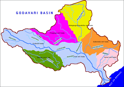
The Godavari (IAST: Godāvarī, [ɡod̪aːʋəɾiː]) is India's second longest river after the Ganga River, and drains the third largest basin in India, covering about 10% of India's total geographical area.[5] Its source is in Trimbakeshwar, Nashik, Maharashtra.[6] It flows east for 1,465 kilometres (910 mi), draining the states of Maharashtra (48.6%), Telangana (18.8%), Andhra Pradesh (4.5%), Chhattisgarh (10.9%) and Odisha (5.7%). The river ultimately empties into the Bay of Bengal through an extensive network of distributaries.[7] Its 312,812 km2 (120,777 sq mi) drainage basin is one of the largest in the Indian subcontinent, with only the Ganga and Indus rivers having a larger drainage basin.[8] In terms of length, catchment area and discharge, the Godavari is the largest in peninsular India, and had been dubbed as the Dakshina Ganga (Southern Ganges).[9]
The river has been revered in Hindu scriptures for many millennia[citation needed] and continues to harbour and nourish a rich cultural heritage. In the past few decades, the river has been barricaded by several barrages and dams, keeping a head of water (depth) which lowers evaporation. Its broad river delta houses 729 persons/km2 – nearly twice the Indian average population density and has a substantial risk of flooding, which in lower parts would be exacerbated if the global sea level were to rise.[10][11]
Course
[edit]


The Godavari originates in the Western Ghats of central India near Nashik in Maharashtra, 80 km (50 mi) from the Arabian Sea. It flows for 1,465 km (910 mi), first eastwards across the Deccan Plateau then turns southeast, entering the Eluru district and Alluri Sitharama Raju district of Andhra Pradesh, until it splits into two distributaries that widen into a large river delta at Dhavaleshwaram Barrage in Rajamahendravaram and then flows into the Bay of Bengal.[13]
The Godavari River has a coverage area of 312,812 km2 (120,777 sq mi), which is nearly one-tenth of the area of India and is equivalent to the area of the United Kingdom and Republic of Ireland put together. The river basin is considered to be divided into 3 sections:
- Upper (source to the confluence with Manjira),
- Middle (between confluence of Manjira and Pranhita) and
- Lower (Pranhita confluence to mouth).
These put together account for 24.2% of the total basin area.[14] The rivers annual average water inflows are nearly 110 billion cubic metres.[15] Nearly 50% of the water availability is being harnessed. The water allocation from the river among the riparian states are governed by the Godavari Water Disputes Tribunal. The river has highest flood flows in India and experienced recorded flood of 3.6 million cusecs in the year 1986 and annual flood of 1.0 million cusecs is normal.[16][17]
Within Maharashtra
[edit]The river originates in Maharashtra state and has an extensive course. The upper basin (origin to its confluence with Manjira) of which lies entirely within the state, cumulatively draining an area as large as 152,199 km2 (58,764 sq mi) – about half the area of Maharashtra.[18] Within Nashik district, the river assumes a north-easterly course until it flows into the Gangapur Reservoir created by a dam of the same name. The reservoir along with the Kashypi Dam provides potable water to Nashik, one of the largest cities located on its banks. The river as it emerges through the dam, some 8 km (5.0 mi) upstream from Nashik, flows on a rocky bed undulated by a series of chasms and rocky ledges, resulting in the formation of two significant waterfalls – the Gangapur and the Someshwar waterfalls. The latter, located at Someshwar is more popularly known as the Dudhsagar Waterfall.[19] About 10 km (6.2 mi) east of Gangapur the river passes the town of Nashik where it collects its effluents in the form of the river Nasardi on its right bank.[citation needed]
About 0.5 km (0.31 mi) south of Nashik, the river bends sharply to the east, washing the base of a high cliff formerly the site of a Mughal fort, but which is now being eroded away by the action of floods. About 25 km (16 mi) below Nashik is the confluence of the Godavari and one of its tributaries, the Darna. The stream occupies, for nine months in the year, a small space in a wide and gravelly bed, the greyish banks being 4 to 6 m (13 to 20 ft) high, topped with a deep layer of black soil. A few kilometres after its meeting with the Darna, the Godavari swerves to the north-east, before the Banganga, from the north-west, meets it on the left. The course of the main stream then tends more decidedly south. At Nandur-Madhmeshwar, the Kadva, a second large affluent, brings considerable increase to the waters of the Godavari. The river begins its southeasterly course characteristic of rivers of the Deccan Plateau. The river exits the Niphad Taluka of Nashik and enters the Kopargaon taluka, Ahmednagar District. Within Ahmednagar District the river quickly completes its short course, flowing alongside the town of Kopargaon and reaching Puntamba. Beyond this, the river serves as a natural boundary between the following districts:[citation needed]
- Ahmednagar and Aurangabad: Along the boundary here, it receives its first major tributary the Pravara River, draining the former district[vague]. The confluence is located at Pravarasangam. By virtue of a sub-tributary of Pravara – Mandohol, which originates in Pune District – the basin impinges the Pune district. The river at Paithan has been impounded by the Jayakwadi Dam forming the NathSagar Reservoir. Kalsubai located in Godavari basin, is the highest peak in Maharashtra.
- Beed and Jalna
- Beed and Parbhani: Located along here is its merger with Sindphana, an important tributary[20] which drains a considerably large area within Beed. The sub-tributary river Bindusara forms a landmark at Beed.
The river beyond, near the village Sonpeth, flows into Parbhani. In Parbhani district, the river flows through Gangakhed taluka. As mentioned above, the Godavari is also called Dakshinganga so the city is called as Gangakhed (meaning a village on the bank of Ganga). As per Hindu rituals this place is considered quite important for after death peace to flow ashes into the river.[citation needed]
Its course is relatively non-significant except for receiving two smaller streams – Indrayani and Masuli – merging at its left and right banks, respectively. Within the last taluka of the district Parbhani, Purna, the river drains a major tributary of the same name: Purna.[citation needed]
It then exits into the neighbouring district of Nanded where 10 km (6.2 mi) before reaching the town Nanded, it is impounded by the Vishnupuri Dam and thus with it, bringing Asia's largest lift irrigation projects to life. A little downstream from Nanded, the river receives Asna, a small stream, on its left bank. It then runs into the controversial Babli project soon ends its course within Maharashtra, albeit temporarily, at its merger with a major tributary – Manjira.[citation needed]
The river after flowing into Telangana, re-emerges to run as a state boundary separating the Mancherial, Telangana from Gadchiroli, Maharashtra. At the state border, it runs between Sironcha and Somnoor Sangam receiving one tributary at each of those nodal points – the Pranhita and subsequently the Indravati.[citation needed]
Within Telangana
[edit]
Godavari enters into Telangana in Nizamabad district at Kandakurthy where Manjira, Haridra rivers joins Godavari and forms Triveni Sangamam. The river flows along the border between Nirmal and Mancherial districts in the north and Nizamabad, Jagtial, Peddapalli districts to its south. About 12 km (7.5 mi) after entering Telangana it merges with the back waters of the Sriram Sagar Dam. The river after emerging through the dam gates, enjoys a wide river bed, often splitting to encase sandy islands. The river receives a minor but significant tributary Kadam river. It then emerges at its eastern side to act as a state border with Maharashtra only to later enter into Bhadradri Kothagudem district. In this district, the river flows through an important Hindu pilgrimage town – Bhadrachalam.[citation needed]
The river further swells after receiving a minor tributary Kinnerasani River and exits into Andhra Pradesh.
Within Andhra Pradesh
[edit]
Within the state of Andhra Pradesh, the river flows through hilly terrain of the Eastern Ghats known as the Papi hills which explains the narrowing of its bed as it flows through a gorge for a few km, only to re-widen at Polavaram. The deepest bed level of a submarine plunge pool in Godavari River, located 36 km upstream of Polavaram dam, is at 45 meters below the sea level.[21] Before crossing the Papi hills, it receives its last major tributary Sabari River on its left bank. The river upon reaching the plains begins to widen out until it reaches Rajamahendravaram. Arma Konda (1,680 m (5,510 ft)) is the highest peak in the Godavari river basin as well as in the Eastern Ghats.[22]
Dowleswaram Barrage was constructed across the river in Rajamahendravaram. At Rajamahendravaram, the Godavari splits into two large branches which are called Gautami (Gautami Godavari) and Vasishta Godavari and five smaller branches. Similarly, the Vasishta splits into two branches named Vasishta and Vainateya. These four branches which join the Bay of Bengal at different places, form a delta of length 170 km (110 mi) along the coast of the Bay of Bengal and is called the Konaseema region. This delta along with the delta of the Krishna River is called the Rice Granary of South India.[23]
Within Puducherry
[edit]The Gautami which is the largest branch of the whole passes along Yanam enclave of Union territory of Puducherry and empties into sea at Point Godavery.[24] In fact, Yanam is bounded on south by Gautami branch and the Coringa River originates at Yanam which merges into the sea near Coringa village in Andhra Pradesh.[25]

Discharge
[edit]Mean annual, minimum and maximum discharge (Q – m3/s) at Rajahmundry (period from 1998/01/01 to 2023/12/31):[2][3]
| Year | Discharge (m3/s) | Year | Discharge (m3/s) | ||||
|---|---|---|---|---|---|---|---|
| Min | Mean | Max | Min | Mean | Max | ||
| 1998 | 900 | 3,863 | 8,018 | 2011 | 2,325 | 4,969 | 8,875 |
| 1999 | 552 | 3,411 | 7,901 | 2012 | 878 | 3,198 | 6,184 |
| 2000 | 732 | 3,052 | 6,732 | 2013 | 1,099 | 3,681 | 7,327 |
| 2001 | 79 | 2,378 | 6,525 | 2014 | 455 | 2,564 | 5,363 |
| 2002 | 774 | 3,360 | 6,413 | 2015 | 761 | 2,297 | 4,353 |
| 2003 | 2,070 | 5,114 | 8,571 | 2016 | 1,019 | 2,401 | 4,802 |
| 2004 | 2,764 | 5,142 | 8,039 | 2017 | 847 | 2,415 | 4,633 |
| 2005 | 1,368 | 4,162 | 8,100 | 2018 | 981 | 2,791 | 5,537 |
| 2006 | 988 | 3,097 | 6,753 | 2019 | 496 | 2,625 | 5,791 |
| 2007 | 1,361 | 3,674 | 6,703 | 2020 | 1,575 | 3,061 | 6,492 |
| 2008 | 969 | 3,594 | 6,753 | 2021 | 1,225 | 3,706 | 7,147 |
| 2009 | 2,111 | 4,669 | 7,436 | 2022 | 1,193 | 4,950 | 9,430 |
| 2010 | 2,534 | 6,355 | 10,403 | 2023 | 2,570 | 6,599 | 12,045 |
| 1998–2023 | 1,255 | 3,740 | 7,127 | ||||
Tributaries
[edit]The major left bank tributaries[26] include the Purna, Pranhita, Indravati, and Sabari River, covering nearly 59.7% of the total catchment area of the basin. The right bank tributaries Pravara, Manjira, and Manair contribute 16.1% of the basin.
The Pranhita River is the largest tributary of the Godavari River, covering about 34% of its drainage basin.[27] Though the river proper flows only for 113 km (70 mi), by virtue of its extensive tributaries Wardha, Wainganga, Penganga, the sub-basin drains all of Vidharba region as well as the southern slopes of the Satpura Ranges. Indravati is the 2nd largest tributary, known as the "lifeline" of the Kalahandi, Nabarangapur of Odisha and Bastar district of Chhattisgarh. Due to their enormous sub-basins both Indravati and Pranhita are considered rivers in their own right. Manjira is the longest tributary and holds the Nizam Sagar reservoir. Purna is a prime river in the water scarce Marathwada region of Maharashtra.[citation needed]
| Tributary | Bank | Confluence location | Confluence elevation | Length | Sub-basin area |
|---|---|---|---|---|---|
| Pravara | Right | Pravara Sangam, Nevasa, Ahmednagar, Maharashtra | 463 m (1,519 ft) |
208 km (129 mi) |
6,537 km2 (2,524 sq mi) |
| Purna | Left | Jambulbet, Parbhani, Marathwada, Maharashtra | 358 m (1,175 ft) |
373 km (232 mi) |
15,579 km2 (6,015 sq mi) |
| Manjira | Right | Kandakurthi, Renjal, Nizamabad, Telangana | 332 m (1,089 ft) |
724 km (450 mi) |
30,844 km2 (11,909 sq mi) |
| Manair | Right | Arenda, Manthani, Peddapalli, Telangana | 115 m (377 ft) |
225 km (140 mi) |
13,106 km2 (5,060 sq mi) |
| Pranhita | Left | Kaleshwaram, Mahadevpur, Jayashankar Bhupalpally, Telangana | 99 m (325 ft) |
113 km (70 mi) |
109,078 km2 (42,115 sq mi) |
| Indravati | Left | Somnoor Sangam, Sironcha, Gadchiroli, Maharashtra | 82 m (269 ft) |
535 km (332 mi) |
41,655 km2 (16,083 sq mi) |
| Sabari | Left | Kunawaram, Alluri Sitharama Raju district, Andhra Pradesh | 25 m (82 ft) |
418 km (260 mi) |
20,427 km2 (7,887 sq mi) |
Other than these seven principal tributaries, it has many smaller but significant ones draining into it. Indravati river floodwaters overflow into the Jouranala which is part of Sabari basin. A barrage at 19°7′19″N 82°14′9″E / 19.12194°N 82.23583°E is constructed across the Indravati river to divert Indravati water in to Sabari river for enhanced hydropower generation.
Seven mouths of Godavari
[edit]Before merging into the Bay of Bengal, the Godavari has seven mouths in total and is considered sacred by local Hindus.[29] As per their traditional belief, the holy waters of the Godavari are said to have been brought from the head of Shiva by the Rishi Gautama, and the seven branches by which it is traditionally supposed to have reached the sea are said have been made by seven great rishis known as Sapta Rishis. Thus, they are named after these seven great rishis[30] and are named as Tulyabhāga (Tulya or Kaśyapa), Ātreya (Atri), Gautamī (Gautama), Jamadagni (now replaced by Vṛddhagautamī i.e. Old Gautami), Bhardvāja (Bharadvaja), Kauśika (Visvamitra) and Vaśișțha (Vasishtha).[31] So bathing in these mouths are considered an act of great religious efficacy by native Hindus. These mouths are remembered by a Sanskrit sloka as follow:
tulyātreyī bharadvāja gautamī vṛddhagautamī
kauśikīca vaśiṣṭhaaca tathā sāgaraṃ gataḥ
(Godavari becomes) Tulya, Ātreyi, Bharadvāja, Gautamī, Vṛddhagautamī,
Kauśikī and Vaśiṣṭhaa and then passes into sea.[32][note 1]
Together they are referred as Sapta Godavari and the Godavari river before splitting is referred as Akhanda Godavari.[30] However, there exists another eight mouth named as Vainateyam, which is not one of these traditional seven mouths and is supposed to have been created by a rishi of that name who stole a part of Vasisththa branch. Godavari was frequently referred as Ganga or Ganges by ancient Indian writings.[29] However, the original branches of Kauśika, Bhardwaja and Jamadagni does not exist any longer and the pilgrims bathe in the sea at the spots where they are supposed to have been. The traditional Bharadwāja mouth is in Tirthālamondi (now bordering Savithri Nagar of Yanam and before a Hamlet of Guttenadivi) and the traditional Kauśika mouth is located at Rameswaram, a hamlet of Samathakurru village in Allavaram Mandal of Konaseema district. Traditional mouth of Jamadagni is not known and people instead take bath in the Vriddha Gautami branch at Kundaleswaram village in Katrenikona Mandal of Konaseema district. There is a local legend saying the Injaram and Patha (Old) Injaram (now on the other bank of Gautami river within Island Polavalam mandal of Konaseema district) were split by Godavari river. Thus the Godavari passing between these two now referred as Gautami and the old passage being referred as Vriddha Gautami. In early British records, the Injaram Paragana (district) was counted along with Muramalla village (now located on the other side of Gautami within Island Polavalam mandal) and said to have comprised 22 villages.[33]
Religious significance
[edit]
| Part of a series on |
| Hinduism |
|---|
 |


The river is sacred to Hindus and has several places on its banks that have been places of pilgrimage for thousands of years. Amongst the huge numbers of people who have bathed in her waters as a rite of cleansing are said to have been the deity Baladeva 5000 years ago and the saint Chaitanya Mahaprabhu 500 years ago. Every twelve years, the Pushkaram fair is held on the banks of the river.[34]

A legend has it that the sage Gautama lived in the Brahmagiri Hills at Tryambakeshwar with his wife Ahalya. The couple lived the rest of their lives in the then village called Govuru, now known as Kovvur ("cow") since British rule. Ahalya lived in a nearby place called Thagami (now Thogummi). The sage, as a reason for the practice of annadanam ("giving away food" to the needy), started cultivating rice crops and other crops. Once, the god Ganesha, on the wish of the sages, sent a miraculous cow mayadhenu, which resembled a normal cow. It entered the sage's abode and started spoiling the rice while he was meditating. Since cattle is sacred to Hindus and treated with respect, he put the darbha grass on the cow. But, to his surprise, it fell dead. Seeing what happened before their eyes, the sages and their wives cried out, "We thought that Gautama-maharishi is a righteous man, but he committed bovicide (killing of a cow or cattle)!". The sage wished to atone for this grievous sin. Therefore, he went to Nashik and observed tapas (penance) to propitiate Tryambakeshvara (a manifestation of the god Shiva), on the advice of the sages, praying for atonement and asking him to make the Ganges flow over the cow. Shiva was pleased with the sage and diverted the Ganges, which washed away the cow and gave rise to the Godavari River in Nashik. The water stream flowed past Kovvur and ultimately merged with the Bay of Bengal.
Sapta Sāgara Yatra
[edit]In olden days a pilgrimage named as sapta sāgara yātra was made by those desirous of offspring along the banks of the holy waters from the seven mouths.[35] It starts with holy bathing at Tulyabhaga river at Chollangi village on Amavasya during Krishna Paksha of Pushya month as per Hindu calendar. That day is locally referred as Chollangi Amavasya. That place where the river branch merges with sea is referred as Tulya Sāgara Sangamam.[36] Secondly, they take bath in Coringa village in the Coringa river which is considered as Atreya branch of Godavari and the holy bathing place is called as Atreya Sāgara Sangamam.[37] After bathing at different banks of the other branches the pilgrimage ends by bathing near Narsapuram or Antarvedi.
Settlements along the Godavari
[edit]
Maharashtra
[edit]- Nashik (Holy city and site of Simhastha Kumbha Mela bathing festivals)
- Trimbakeshwar (shrine to the Jyotirlinga of the god Shiva)
- Kopargaon
- Puntamba – A place of pilgrimage with several ancient temples including the last resting place (Samadhi) of Sant Changdev in Puntamba. This town is located in Rahata Taluka of Ahmednagar district and 18 km from holy place of Sai Baba of Shirdi. A temple attributed to Kartikeya (younger son of Shiva) is located here on bank of river Godavari). River godavari which had entered in kopargaon taluka of Ahmednagar from Niphad taluka of Nashik is the natural frontier between Aurangabad and Ahmednagar districts of Maharashtra onwards until it enters in confluence with river Pravara at Pravarasangam village which comes under Newasa taluka a town where famous Bhakti saint Shree sant Dhnyaneshwar had written critic on Bhagavatgeeta 'Dhnyaneshwari'.[citation needed]
- Paithan (ancient capital of the Satavahana dynasty)
- Gangakhed
- Nanded (location of the Hazur Sahib Nanded Sikh Gurdwara)
- Sironcha (town situated near the confluence of Godavari and Pranahita rivers)
Telangana
[edit]
- Basara, Nirmal district (Gnana Saraswati Temple)
- Goodem gutta, Adilabad (temple) Luxettipet, Adilabad
- Mancherial, Mancherial
- Godavarikhani, Ramagundam
- Nirmal, Nirmal district (Nirmal toys)
- Chennur, Adilabad
- Tadpakal, Nizamabad district (Armoor toys)
- Battapur, Nizamabad district (Armoor toys)
- Dharmapuri, Jagtial district
- Godavarikhani, Ramagundam, Sripada Yellampalli Project
- Manthani, Peddapalli district (Gautameshwara Swami (Shiva) temple, Rama, Saraswati temples)
- Kaleshwaram, Jayashankar Bhupalpally district (Kaleswara Mukhteswara Swamy (Shiva) temple)
- Mahadevpur Jayashankar Bhupalpally district
- Eturnagaram, Jayashankar Bhupalpally district
- Manuguru, Bhadradri Kothagudem district
- Bhadrachalam, Bhadradri Kothagudem district
Andhra Pradesh
[edit]

- Polavaram, Eluru district (Sri Bhadrakalisametha Sri Veereswara Swami temple)
- Rajamahendravaram, East Godavari (where the Akhanda Godavari splits into two streams called "Gautami" and "Vashista" before joining Bay of Bengal)
- Kovvur, East Godavari district
- Ravulapalem, Konaseema district
- Kothapeta, Konaseema district
- Mukteswaram, Dr. B.R. Ambedkar Konaseema district (Sri Kshana Muktheswara Swamy temple)
- Kotipalli, Konaseema district (Sri Someswara Swamy temple)
- Antarvedi, Konaseema district (Antarvedi is famous for the Sri Laxmi Narasimha Swamy temple constructed between the 15th and 16th centuries. There is also a temple of Shiva that is older than Narasimha Swamy temple. The temple's idol of Shiva was installed by Rama.)
- Narasapuram, West Godavari district
Puducherry
[edit]- Yanam district (Yanam is an enclave located in East Godavari district, where the Gautami joins the Bay of Bengal. It belongs to Puducherry union territory.)
Places of interest
[edit]Sites of pilgrimage include:
- Basar (originally, Vyasara) – Sri Gyana Saraswati temple is situated on the banks of Godavari in Adilabad district, Telangana. It is about 210 km (130 miles) from state capital Hyderabad and accessible by road and rail (nearest major station: Nizamabad, although Basar station also exists). It is considered that the sage Vyasa wrote the Mahabharata on the banks of Godavari at this location near Harsha house it is the beautiful scenario, and thus the place came to be known as Vyasara.
- Kandhakurthi – Thriveni sangamam where three rivers join. Godavari, Manjira River and Haridra River
- Bhadrachalam – Hindu Temple of Rama constructed by Bhakta Ramdas in the 16th century
- Dharmapuri, Telangana – Hindu Temple of Narasimha. Godavari flows from north to south in Dharmapuri, hence the river is locally called 'Dakshina Vahini' [South Flowing]
- Kaleshwaram – Sri Kaleswara Mukhteswara swamy Temple is situated here on the banks of Triveni sangamam of rivers Godavari and Pranahita. It is 125 kilometres away from Karimnagar city, 115 km away from Warangal city.
- Trimbakeshwar – One of the twelve Jyotirlingas and ancient temple of Shiva
- Nanded – Takht Sri Hazur Sahib, second of the five most sacred places in Sikhism
- Nashik – One of the four Sinhastha Kumbh Mela, a Hindu pilgrimage place
- Paithan – Saint Eknath's native place, famous Jayakwadi Dam, and a beautiful garden named after Sant Dhnyaneshwar.

- Antarvedi, Konaseema district – Antarvedi is famous for the Laxmi Narasimha Swamy temple constructed between the 15th and 16th centuries. There is also a temple of Shiva that is older than Narasimha Swamy temple. The temple's idol of Shiva was installed by Rama.
- Konaseema – Delta of Godavari
- Pattiseema – A village where a Hindu temple is located on a small hill on an island in the river
- Kovvur – A village where cows resided and a place where the maaya-dhenu fell dead. Footprints of the maaya-dhenu were seen even today in the famous place Kovvur called "Goshpadakshetram" also called "Gopadala Revu" where the footprints of the holy cow are seen near the temple of Shiva. Also a village which is the reason for the birth of river Godavari. It is famous for a Sanskrit school which has been built 63 years ago.
- Rajamahendravaram – A city known for its role in Telugu culture and birthplace of writers such as Nannayya, one of the Kavitrayam trinity of poets who translated the Mahabharata into Telugu. It is known for floriculture, tourism, industries and its heritage The Godavari Pushkaralu is a major local festival that is staged every 12 years.
- Deomali peak located in the Godavari basin is the highest peak (1672 m msl) in Odisha state.
Flora and fauna
[edit]- The Krishna Godavari Basin is one of the main nesting sites of the endangered olive ridley sea turtle. Godavari is also a home to the endangered fringed-lipped carp (Labeo fimbriatus).[38]
- The Coringa mangrove forests in the Godavari delta are the third largest mangrove formation in the country. Part of this has been declared as the Coringa Wildlife Sanctuary, renowned for reptiles. They also provide an important habitat to a wide variety of fish and crustaceans. These forests also act as barriers against cyclones, tropical storms, and storm surges, thus protecting the nearby villages.
- The Jayakwadi Bird Sanctuary is another haven for birds located near the town of Paithan spread across the back waters of the NathSagar Reservoir formed by impounding the Godavari by the massive Jayakwadi Dam. Its 341 km2 area is dotted by islands within the reservoir which serve as nesting sites for the birds.[39]
- The Nandurmadmeshwar Bird Sanctuary is located along the back waters of the Godavari River near Nashik at its confluence with Kadva River.[40] It is known as the Bharatpur of Maharashtra for the wide diversity of bird life that it harbours.
The following are few other wildlife sanctuaries located in the river basin:
- Bor Wildlife Sanctuary
- Eturnagaram Wildlife Sanctuary
- Gautala Wildlife Sanctuary
- Indravati National Park
- Kanger Ghati National Park
- Kawal Wildlife Sanctuary
- Kinnerasani Wildlife Sanctuary
- Kolleru Wildlife Sanctuary
- Manjira Wildlife Sanctuary
- Nagzira Wildlife Sanctuary
- Navegaon National Park
- Painganga Wildlife Sanctuary
- Papikonda Wildlife Sanctuary
- Pench National Park
- Pocharam Forest & Wildlife Sanctuary
- Pranahita Wildlife Sanctuary
- Tadoba Andhari Tiger Project
- Tipeshwar Wildlife Sanctuary
Waterfalls
[edit]Duduma Waterfalls is 175 metres (574 ft) high and one of the highest waterfalls in southern India.[citation needed] It is located on the Sileru River which forms boundary between Andhra Pradesh and Odisha states. The following are a few other waterfalls located in the river basin:

Crossings
[edit]
There are 4 bridges spanning the river between East Godavari and West Godavari districts.
- Old Godavari Bridge (also known as Havelock bridge, and named after then Madras governor)
- Godavari Bridge (also known as Rail-cum-road bridge and Kovvur-Rajahmundry Bridge)
- Godavari Arch Bridge (also known as New railway bridge)
- Godavari Fourth Bridge (also known as new road bridge)
Details:
- Old Godavari Bridge. Construction of this bridge started in 1876, and was completed in 1897. It was constructed under the supervision of F.T. Granville Walton who had constructed the Dufferin Bridge over the Ganges, and Granville Mills, both British engineers. Spanning over 3 km in length, it linked the East Godavari and West Godavari districts. The bridge has been a vital link enabling trains to run between Chennai and Howrah. Trains continued over the bridge for a century until 1997, when train services over the bridge were suspended after the construction of two additional bridges.
- Godavari Bridge. Construction of this bridge started in 1970, and was completed in 1974. It serves as both a railway and a roadway between the East Godavari and West Godavari Districts.
- Godavari Arch Bridge. This bridge was completed in 1997, was built upstream of the earlier bridges.
- Godavari Fourth Bridge. This bridge is the newest. It was opened to public from Godavari Pushkaras 2015. This is a road connectivity bridge link supposed to ease traffic flow between Rajamahendravaram and Kovvur
Dams
[edit]
.jpg)

The main Godavari River up to the confluence with Pranhita tributary is dammed fully to utilize the available water for irrigation. However, its main tributaries Pranhita, Indravati and Sabari which join in the lower reaches of the basin, carry three times more water compared to main Godavari. In 2015, the water surplus Godavari River is linked to the water deficit Krishna River by commissioning the Polavaram right bank canal with the help of Pattiseema lift scheme to augment water availability to the Prakasam Barrage located in Andhra Pradesh. More dams are constructed in the Godavari River basin than in any other river basin of India.[41] The following are the few dams located in the river basin:
- Gangapur Dam: This is a large earth fill dam with gross water storage of 215.88 million cubic metres,[42] and located 10 km (6.2 mi) upstream from Nashik city. The reservoir known as the Gangapur Bandh Sagar provides drinking water to the Nashik city and also supplies water to the thermal power station situated downstream at Eklahare.
- Jayakwadi Dam: Located near Paithan, it is one of the largest earthen dams in India. This dam was built to address the dual problems of flooding along the banks, during monsoon months, and that of drought, rest of the year, in the Marathwada region. Two 'left' and 'right' canals provide the irrigation to fertile land up to Nanded district. This dam has contributed to industrial development of Aurangabad and Jalna, Maharashtra.[43] Majalgaon Dam is also constructed under Jayakwadi stage 2 to expand the irrigation potential further in Parbhani, Nanded and Beed districts.
- Vishnupuri barrage: Asia's Largest Lift Irrigation project, the Vishnupuri Prakalp[44] has been constructed on the river at a distance of 5 km (3.1 mi) from the city Nanded.
- Ghatghar Dam was built for hydro power generation by diverting the water of Pravara tributary outside Godavari river basin to a west flowing river which joins Arabian sea.
- Upper Vaitarna reservoir was built across west flowing Vaitarna river merging some part of Godavari river catchment area. Godavari water impounded in this reservoir is diverted outside the river basin for Mumbai city drinking water supply after generating hydro power.
- Sriram Sagar Dam: This is another multipurpose project on the Godavari River on the borders of Adilabad and Nizamabad District. It is near the town of Pochampadu, 60 km away from Nizamabad. It has been described by The Hindu as a "lifeline for a large part of Telangana".[45] It serves the irrigation needs in Karimnagar, Warangal, Adilabad, Nalgonda, and Khammam districts and also generates power.
- Sir Arthur Cotton Barrage was built by Sir Arthur Cotton in 1852. It got damaged in 1987 floods, and rebuilt as a barrage cum roadway soon after and named after him. The roadway connects Rajamahendravaram in East Godavari and Vijjeswaram in West Godavari. The irrigation canals of this barrage also form part of National Waterway 4.
Hydro power stations
[edit]
The Godavari River in Maharashtra is one of the rivers whose water energy is least harnessed for generating hydro electricity.[46] The 600 MW capacity Upper Indravati hydro power station is the biggest hydro power station which diverts Godavari River water to the Mahanadi River basin.[47] The following is the list of hydro electric power stations excluding small and medium installations.
| Name of the project | Rated Power (in MW) |
|---|---|
| Upper Indravati | 600 |
| Machkund | 120 |
| Balimela | 510 |
| Upper Sileru | 240 |
| Lower Sileru | 460 |
| Upper Kolab | 320 |
| Pench | 160 |
| Ghatghar pumped storage | 250 |
| Polavaram (under construction) | 960 |
Unutilized water
[edit]Nearly 2490 tmcft of water has gone waste to the sea on average in a water year from 1 June 2003 to 31 May 2022 (19 years). The yearly water unutilized is given below
| Water year | 03-04 | 04-05 | 05-06 | 06-07 | 07-08 | 08-09 | 09-10 | 10–11 | 11–12 | 12–13 | 13–14 | 14–15 | 15–16 | 16–17 | 17–18 | 18–19 | 19–20 | 20–21 | 21–22 |
|---|---|---|---|---|---|---|---|---|---|---|---|---|---|---|---|---|---|---|---|
| Unutilized water (tmcft) | 3190 | 1628 | 301 | 4875 | 2862 | 1819 | 743 | 4015 | 1538 | 2969 | 5827 | 2006 | 1611 | 2896 | 1026 | 2435 | 1757 | 3436 | 2377 |
There is least possibility to construct new reservoirs in the river basin area due to land submergence and displacement of population. However, a freshwater coastal reservoir, located on the adjacent sea, with adequate storage capacity (nearly 29 billion m3) is economically feasible to harness the remaining unutilized water in the river.[49]
Geology and sediment transfer in the Godavari Drainage Basin
[edit]
The primary and initial catchment of the Godavari drainage basin is largely represented by the basalt of the Deccan Volcanic Province (~50% of the total basin area). This is followed by the Precambrian granites and gneisses of the eastern Dharwar Craton, sandstones, shales and limestones of the Gondwana Supergroup, various sedimentary units of Cuddapah and Vindhyan basins, charnockites and khondalites of the Proterozoic Eastern Ghats Mobile Belt and the sandstones of the Rajahmundry Formation.[50] The Godavari River carries the largest sediment load among the peninsular rivers and the majority of the mass transfer in Godavari occurs during the monsoon.[51] Mineral magnetic studies of the Godavari River sediments suggest that the floodplains in the entire stretch of the river are characterized by a Deccan basalt source. The bed loads on the other hand are of sourced from local bedrock. Influx of Deccan source in the Godavari River up to the delta regions and possibly in the Bay of Bengal off the Godavari, therefore, can be related to the intensive chemical weathering in the Deccan basalts.[50] Abrupt increase in δ13C values and decrease in TOC content accompanied with a significant increase in ferrimagnetic mineral concentration in Bay of Bengal sediments from ~3.2 to 3.1 cal. ka BP reflected a shift of organic carbon and sediment source and a severe decline in vegetation coverage. Such phenomena indicate intensified deforestation and soil/rock erosion in the Deccan Plateau producing higher ferrimagnetic mineral inputs, which is in agreement with significant expansion of agricultural activities in the Deccan Chalcolithic cultural period.[52]
Mineral deposits
[edit]The Godavari River basin is endowed with rich mineral deposits such as oil and gas, coal, iron, limestone, manganese, copper, bauxite, granite, laterite, and others. The following are the few noted deposits:
- Araku hills, bauxite
- Godavari Valley Coalfield, coal
- Bailadila iron, iron
- Krishna Godavari Basin, oil & gas
- Malanjkhand, copper
- MOIL, manganese
- Pench Kanhan Coalfield, coal
- Rowghat Mines, iron
- Wardha Valley Coalfield, coal
- River plunge pools across Papikondalu, gold
Ecological concerns
[edit]
The frequent drying up of the Godavari River in the drier months has been a matter of great concern. Indiscriminate damming along the river has been cited as an obvious reason. Within Maharashtra sugarcane irrigation has been blamed as one of the foremost causes.[53]
In 2013, the river was at its all-time low in the Nizamabad district of Telangana. This had hit the growth of fish, making the life of fishermen miserable. The water-level was so low that people could easily walk into the middle of the river. Shortage in rainfall and closure of the controversial Babli project gates in Maharashtra was thought to have affected the water flow in the river and water availability to the Sriram Sagar Project except during above 20% excess monsoon (i.e. one out of four years) years.[54]
A study has found that the delta is at a greater risk as the rate of sediment aggradation (raising the level of the delta through sediment deposition) no longer exceeds relative sea level rise.[55] It further states that the suspended sediment load at the delta has reduced from 150·2 million tons during 1970–1979 to 57·2 million tons by 2000–2006,[56] which translates into a three-fold decline in the past 4 decades. Impacts of this can be seen in destroyed villages like Uppada in Godavari delta,[57] destruction of Mangrove forests and fragmentation of shoreline – possibly a fallout of dam construction.
Said to further epitomise the insensitivity towards Godavari, is the Polavaram Project which is touted to be gigantic – both in terms of size and violations.[58] Deemed as being pointless and politically driven,[59] the project raises questions about environmental clearance, displacement of upstream human habitations,[60] loss of forest cover, technicalities in the dam design which are said to play down flood threats and unsafe embankments.
High alkalinity water is discharged from the ash dump areas of many coal fired power stations into the river which further increases the alkalinity of the river water whose water is naturally of high alkalinity since the river basin is draining vast area of basalt formations.[61] This problem aggravates during the lean flow months in entire river basin. Already the Godavari basin area in Telangana is suffering from high alkalinity and salinity water problem which is converting soils in to unproductive sodic alkali soils.[62] The following are the few coal fired power stations located in the river basin:
| Name of Power Station | Rated Power (in MW) |
|---|---|
| Koradi Thermal Power Station | 2,600 |
| Khaparkheda Thermal Power Station | 1,340 |
| Tiroda Thermal Power Station | 3,300 |
| Butibori Power Plant | 600 |
| RattanIndia Nashik TPS | 1,350 |
| Chandrapur STPS | 3,340 |
| Mauda Super Thermal Power Station | 1,000 |
| Parli Thermal Power Station | 1,130 |
| Dhariwal Power Station | 300 |
| Nashik Thermal Power Station | 910 |
| Wardha Warora Power Plant | 540 |
| Pench Thermal Power Plant | 1,320 |
| Lanco Vidarbha Thermal Power | 1,320 |
| NTPC Ramagundam | 2,600 |
| Kothagudem Thermal Power Station | 1,720 |
| Kakatiya Thermal Power Station | 1,100 |
| Ramagundam B Thermal Power Station | 60 |
| Manuguru Heavy water plant's power station | 90 |
| Singareni thermal power station | 1,800 |
| Bhadradri Thermal Power Plant | 1,080 |
In popular culture
[edit]One of the ships of the Indian Navy has been named INS Godavari after the river. Godavari is also the codename of some variants of AMD APU chips.[citation needed]
See also
[edit]References
[edit]- ^ Godāvari River at GEOnet Names Server
- ^ a b c "River Discharge and Reservoir Storage Changes Using Satellite Microwave Radiometry".
- ^ a b c d "The Flood Observatory".
- ^ "Sage River Database". Archived from the original on 21 June 2010. Retrieved 16 June 2011.
- ^ "The Godavari River System" (PDF). cwc.gov.in. Central Water Commission, Ministry of Jal Shakti, Department of Water Resources, River Development and Ganga Rejuvenation. Archived (PDF) from the original on 8 August 2021.
- ^ ""Godavari river basin map"" (PDF). Archived from the original (PDF) on 12 October 2013. Retrieved 2 November 2015.
- ^ "Integrated Hydrological DataBook (Non-Classified River Basins)" (PDF). Central Water Commission. p. 9. Archived from the original (PDF) on 4 March 2016. Retrieved 13 October 2015.
- ^ "Basins –". Archived from the original on 23 September 2015. Retrieved 12 October 2015.
- ^ "Dakshina Ganga (Ganga of South India) – River Godavari". Important India. 20 January 2014. Archived from the original on 18 January 2016. Retrieved 21 October 2015.
- ^ "Deltas at Risk" (PDF). International Geosphere-Biosphere Programme. Archived (PDF) from the original on 8 December 2015. Retrieved 21 May 2019.
- ^ South Asia Network on Dams Rivers and People (2014). "Shrinking and Sinking Deltas: Major role of Dams in delta subsidence and effective sea level rise" (PDF). Archived (PDF) from the original on 6 February 2016. Retrieved 15 January 2016.
- ^ "India: Andhra Pradesh Flood 2005 situation report, 21Sep 2005". 29 May 2014. Archived from the original on 27 October 2020. Retrieved 15 January 2016.
- ^ "Godavari basin status report, March 2014" (PDF). Archived from the original (PDF) on 17 November 2015. Retrieved 15 November 2015.
- ^ "Rivers of Western Ghats". Archived from the original on 19 July 2011. Retrieved 9 December 2006.
- ^ "Spatial variation in water supply and demand across river basins of India" (PDF). IWMI Research Report 83. Archived (PDF) from the original on 16 July 2010. Retrieved 23 June 2015.
- ^ "When Bhadrachalam was under a sheet of water". The Hindu. 12 December 2011. Archived from the original on 9 April 2017. Retrieved 26 May 2014.
- ^ "Water flow data at Polavaram". Archived from the original on 28 December 2019. Retrieved 26 May 2014.
- ^ "About the Godavari Basin". Archived from the original on 21 April 2015. Retrieved 19 October 2015.
- ^ "Dudhsagar Waterfalls, Nashik". Nashik Directory. Archived from the original on 4 March 2016. Retrieved 18 October 2015.
- ^ "Beed district". Government of Maharashtra. Retrieved 15 January 2016.
- ^ "Polavaram project studies by NGT (page 56)" (PDF). Archived (PDF) from the original on 16 September 2020. Retrieved 1 October 2020.
- ^ Kenneth Pletcher (2010). The Geography of India: Sacred and Historic Places. The Rosen Publishing Group. p. 28. ISBN 978-16-1530-142-3.
- ^ Nageswara Rao, Kakani; Rao, Kakani Nageswara; Saito, Yoshiki; Nagakumar, K. Ch V.; Demudu, G.; Basavaiah, N.; Rajawat, A. S.; Tokanai, Fuyuki; Kato, Kazuhiro; Nakashima, Rei (2012). "Holocene environmental changes of the Godavari Delta, east coast of India, inferred from sediment core analyses and AMS 14C dating". Geomorphology. 175–176: 163–175. Bibcode:2012Geomo.175..163N. doi:10.1016/j.geomorph.2012.07.007 – via www.academia.edu.
- ^ Alexander Dalrymple (1808). Oriental Repertory: Published at the Charge of the East India Company, Volume 2. W. Ballintine. p. 81.
- ^ Victor Jaccarini, Els Martens (2013). The Ecology of Mangrove and Related Ecosystems. Springer Science & Business Media. p. 12. ISBN 9789401732888.
- ^ Central Water Commission (2012). "Integrated Hydrological Data Book (Non-classified river basins)" (PDF). Archived from the original (PDF) on 4 March 2016. Retrieved 15 January 2016.
- ^ Jain, S. K.; Agarwal, Pushpendra K; Singh, V. P. (2007). Hydrology and water resources of India. Springer. p. 676. Bibcode:2007hwri.book.....J.
- ^ "Hydrology and water resources information for India". www.nih.ernet.in. National Institute of Hydrology, India. Archived from the original on 21 April 2015. Retrieved 19 October 2015.
- ^ a b William F. R. Hemingway (1915). "Godavari District Gazetteer (reprint), Volume 1" (PDF). Asian Educational Services. p. 6. Archived (PDF) from the original on 7 July 2022.
- ^ a b Baidyanath Saraswati (1984). The Spectrum of the Sacred: Essays on the Religious Traditions of India. Concept Publishing Company. p. 41.
- ^ E. Keys (1885). Manual of the Administration of the Madras Presidency, in Illustration of the Records of Government & the Yearly Administration Reports, Volume 2. Madras (India: Presidency). p. 79.
- ^ "సప్త గోదావరీ ప్రస్థానం" (in Telugu). 12 July 2015. Retrieved 30 July 2022.
- ^ Great Britain. Parliament. House of Commons. Select Committee on the East India Company (1966). Madras Presidency. J. Higginbotham. p. 214 – via Google Books.
- ^ "Godavari River – Tributaries Course Hydropower Stations". Rivers Of India – All About Rivers. Archived from the original on 27 May 2022. Retrieved 27 May 2022.
- ^ Edgar Thurston (2011). The Madras Presidency with Mysore, Coorg and the Associated States. Cambridge University Press. p. 24. ISBN 9781107600683.
- ^ India. Office of the Registrar General (1976). Census of India, 1971: Andhra Pradesh, Volume 6, Part 2, Issue 2. Manager of Publications. p. 353.[permanent dead link]
- ^ The March of India. 1954. p. 23.
- ^ Venkateshwarlu, K. (3 May 2012). "Godavari". The Hindu. Archived from the original on 6 April 2021. Retrieved 16 May 2012.
- ^ Maharashtra Forest Department. "Aurangabad Circle". Archived from the original on 12 November 2014. Retrieved 15 January 2016.
- ^ Nashik. "Nandur Madhmeshwar Bird Sanctuary". Archived from the original on 13 June 2017. Retrieved 15 January 2016.
- ^ "Dams in Godavari basin". Archived from the original on 2 January 2016. Retrieved 17 October 2015.
- ^ "Dams in Nashik District". National Informatics Centre (NIC), Collectorate, Nashik. Archived from the original on 10 August 2013. Retrieved 17 October 2015.
- ^ vijdiw. "Jaikwadi Dam and Its Nath Sagar Reservoir". authorstream.com. Archived from the original on 10 February 2020. Retrieved 15 January 2016.
- ^ "Vishnupuri barrage B00473". Archived from the original on 21 July 2016. Retrieved 30 July 2016.
- ^ Maharashtra projects hit Sriram Sagar project inflows: BJP. The Hindu, 16 May 2005
- ^ "Power Houses in Godavari Basin". Archived from the original on 17 November 2015. Retrieved 27 March 2015.
- ^ "Upper Indravati Power_House PH01496". Archived from the original on 17 November 2015. Retrieved 27 March 2015.
- ^ "Reservoir Storage Monitoring System". Retrieved 23 June 2022.
- ^ Sasidhar, Nallapaneni (May 2023). "Multipurpose Freshwater Coastal Reservoirs and Their Role in Mitigating Climate Change" (PDF). Indian Journal of Environment Engineering. 3 (1): 31–46. doi:10.54105/ijee.A1842.053123. ISSN 2582-9289. S2CID 258753397. Retrieved 16 May 2024.
- ^ a b Kulkarni, Y. R.; Sangode, S. J.; Meshram, D. C.; Patil, S. K.; Dutt, Yatindra (1 April 2014). "Mineral magnetic characterization of the Godavari river sediments: Implications to Deccan basalt weathering". Journal of the Geological Society of India. 83 (4): 376–384. Bibcode:2014JGSI...83..376K. doi:10.1007/s12594-014-0054-x. ISSN 0016-7622. S2CID 84836147.
- ^ Bikshamaiah, G.; Subramanian, V. (1 April 1980). "Chemical and sediment mass transfer in the Godavari River basin in India". Journal of Hydrology. 46 (3): 331–342. Bibcode:1980JHyd...46..331B. doi:10.1016/0022-1694(80)90085-2.
- ^ Cui, Meng; Wang, Zhanghua; Nageswara Rao, Kakani; Sangode, S J; Saito, Yoshiki; Chen, Ting; Kulkarni, Y R; Naga Kumar, K Ch V; Demudu, G (29 June 2017). "A mid- to late-Holocene record of vegetation decline and erosion triggered by monsoon weakening and human adaptations in the south-east Indian Peninsula". The Holocene. 27 (12): 1976–1987. Bibcode:2017Holoc..27.1976C. doi:10.1177/0959683617715694. ISSN 0959-6836. S2CID 135381556.
- ^ Pawar, Yogesh (18 March 2013). "Krishna, Godavari basins drying up". Archived from the original on 11 November 2020. Retrieved 15 January 2016.
- ^ J. Keller, A. Keller and G. Davids. "River basin development phases and implications of closure" (PDF). Archived from the original (PDF) on 19 October 2013. Retrieved 25 August 2012.
- ^ R Prasad (21 September 2009). "Sinking Indian deltas put millions at risk". The Hindu. Archived from the original on 20 October 2020. Retrieved 15 January 2016.
- ^ South Asia Network on Dams, Rivers and People (2014). "Godavari's Story". Archived from the original on 26 February 2021. Retrieved 15 January 2016.
- ^ B Hema Malini; K Nageswara Raol (10 November 2004). "Coastal erosion and habitat loss along the Godavari delta front – a fallout of dam construction (?)" (PDF). Current Science. 87 (9): 1232. Archived (PDF) from the original on 18 December 2004. Retrieved 15 January 2016.
- ^ Mahapatra, Richard (2011). "Polavaram fraud". Archived from the original on 18 March 2021. Retrieved 15 January 2016.
- ^ Times of India (5 July 2015). "Polavaram dam works to begin on Oct. 22". The Hindu. Archived from the original on 6 February 2016. Retrieved 15 January 2016.
- ^ Rediff News (29 May 2014). "Telangana bandh over Modi govt's ordinance on Polavaram". Archived from the original on 10 September 2016. Retrieved 15 January 2016.
- ^ "Chemical weathering in the Krishna Basin and Western Ghats of the Deccan Traps, India" (PDF).
- ^ "Alkalinity and salinity bane of soil in T state". The Times of India. Archived from the original on 22 January 2021. Retrieved 23 October 2015.
Notes
[edit]- ^ तुल्यात्रेयी भरद्वाज गौतमी वृद्धगौतमी । कौशिकीच वशिष्ठाच तथा सागरं गतः॥
External links
[edit]- Gautami Mahatmya (fourth book of the Brahma-purana) English translation by G. P. Bhatt, 1955 (includes glossary)
- Godavari basin Archived 13 April 2021 at the Wayback Machine
- Rivers Network: Godavari watersheds webmap Archived 28 September 2019 at the Wayback Machine
- . Encyclopædia Britannica. Vol. 12 (11th ed.). 1911. p. 170.
- Nashik City
- Contrasting Behavior of Osmium in the Godavari River Estuary, India, 2001
- Variations of Monsoon Rainfall in Godavari River Basin
- irfca.org


| International | |
|---|---|
| National | |
| Geographic | |
| Other | |
Godavari River
View on GrokipediaPhysical Geography
Origin and Course
The Godavari River originates on Brahmagiri Mountain near Trimbakeshwar in Nashik district, Maharashtra, at coordinates 19°55'47"N 73°31'39"E and an elevation of 1,067 meters above mean sea level.[2] This source lies in the Western Ghats, approximately 24 kilometers from Nashik city.[8] From its origin, the river initially flows eastward through Nashik district, traversing the Deccan Plateau.[8] The Godavari follows a predominantly eastward path for a total length of 1,465 kilometers, establishing it as the longest river in peninsular India.[1] In Maharashtra, it passes through key locations including Nashik, Paithan, and Nanded before entering Telangana.[2] Within Telangana, the river flows southward past Bhadrachalam, then reorients eastward into Andhra Pradesh, where it traverses Rajahmundry en route to its deltaic mouth.[7] The river ultimately discharges into the Bay of Bengal through its extensive delta near Antarvedi in Andhra Pradesh, after covering terrain that shifts from upland plateaus to coastal plains.[1] This course spans primarily Maharashtra, Telangana, and Andhra Pradesh, with the main channel contributing to a basin that extends into adjacent states.[7]Tributaries and Basin
The Godavari River basin spans 312,813 square kilometers, accounting for approximately 9.5 percent of India's total catchment area.[9] This basin primarily covers Maharashtra, which contributes the largest share, followed by Telangana, Andhra Pradesh, Chhattisgarh, and Odisha, with smaller portions in Madhya Pradesh and Karnataka. The terrain varies from the Western Ghats in the upper reaches to the Deccan Plateau and coastal plains downstream, influencing the hydrological regime and sediment transport.[1] The Godavari receives numerous tributaries, with left-bank inflows dominating in volume and catchment contribution, collectively draining about 59.7 percent of the basin. Major left-bank tributaries include the Purna, which joins near the upper course; the Pranhita, formed by the confluence of the Wardha and Wainganga rivers and representing the largest sub-basin; the Indravati originating in Chhattisgarh; and the Sabari from the Eastern Ghats.[1] Right-bank tributaries, though fewer, are significant for regional irrigation and include the Pravara, Manjira (also spelled Manjra), and Maner. The Pranhita sub-basin alone covers over one-third of the total Godavari catchment, underscoring its critical role in the river's discharge.[10]| Bank Side | Major Tributaries | Key Characteristics |
|---|---|---|
| Left | Purna, Pranhita (incl. Wardha, Wainganga, Penganga), Indravati, Sabari | Contribute majority of basin area; Pranhita is the primary water contributor from central India plateaus.[1] |
| Right | Pravara, Manjira, Maner | Drain Deccan regions; support key irrigation projects like Jayakwadi Dam on Manjira.[9] |
Delta Formation and Discharge
The Godavari Delta emerges from the deposition of river-borne sediments as the river decelerates upon entering the Bay of Bengal, forming a broad alluvial plain through progressive silting and progradation over Holocene timescales. This process has built a wave-dominated delta system, where littoral currents and wave action redistribute sands along a fringing beach-ridge plain approximately 30 km wide, while finer silts and clays accumulate in subaqueous and intertidal zones. The delta's lobate morphology results from the interplay of fluvial sediment supply and marine reworking, with historical shifts between river-dominated and wave-influenced growth phases evidenced by barrier-spit accretion and channel avulsions. Holocene-Pleistocene sediments dominate the coastal plain, extending the delta's projection about 35 km seaward from adjacent shores. Covering an area of roughly 5,820 km², the delta features multiple distributaries that branch primarily near Rajahmundry, including the main Gautami Godavari, Vasistha Godavari, and Vainateyam channels, alongside at least seven historically documented mouths facilitating sediment dispersal. The river's substantial annual sediment flux—estimated at 170 teragrams (170 million metric tons)—sustains this buildup, with coarser sands forming beach ridges and mangroves trapping finer clays in swampy backbarrier environments. This sediment load, derived from erosion across the Deccan Traps and basin highlands, exceeds that of neighboring peninsular rivers like the Krishna (4 Tg/yr) and Cauvery (1.5 Tg/yr), enabling the Godavari's more pronounced deltaic expansion despite comparable wave energy. Hydrologically, the Godavari discharges approximately 110 km³ of freshwater annually into the Bay of Bengal via these distributaries, equivalent to an average rate of about 3,500 m³/s, with peaks exceeding 11,000 m³/s during the southwest monsoon (June–September) when basin runoff intensifies. This seasonal variability stems from monsoon-driven precipitation over the 312,812 km² basin, concentrating 80–90% of annual flow in the wet period and reducing to near-zero in dry months, influencing deltaic salinity gradients and sediment suspension. Downstream gauges near the delta, such as at Rajahmundry (80 km upstream of the primary mouths), record these fluctuations, underscoring the river's role in regional freshwater and nutrient delivery despite human modifications like barrages that regulate but do not fundamentally alter natural discharge volumes.Hydrology and Geology
Hydrological Characteristics
The Godavari River basin encompasses 312,812 km², accounting for about 9.5% of India's land area and spanning multiple states including Maharashtra, Telangana, Andhra Pradesh, Chhattisgarh, and Odisha.[1][12] The basin's hydrological regime is characterized by a mean annual rainfall of approximately 1,062 mm, with over 80% concentrated during the southwest monsoon season from June to September, leading to pronounced seasonal flow variations.[13] This monsoon dominance results in high runoff coefficients, contributing to the river's average annual water yield of 110.54 billion cubic meters (BCM), equivalent to an estimated mean discharge of roughly 3,500 m³/s near the estuary.[1] Flow rates exhibit extreme variability, with minimum non-monsoon discharges occasionally falling below 100 m³/s due to reduced precipitation and high evapotranspiration in the semi-arid upper basin regions, while peak monsoon flows can surge to over 30,000 m³/s during intense rainfall events, triggering widespread flooding.[14] Hydrological observations from the Central Water Commission indicate that interannual fluctuations are influenced by El Niño-Southern Oscillation (ENSO) patterns, which weaken the Indian Summer Monsoon Rainfall (ISMR) and reduce streamflow in affected years, as evidenced by data from 1980 to 2008 showing diminished basin-wide discharge during such periods.[15] The river's bimodal flow peaks— one in late pre-monsoon (May-June) from localized cyclonic activity and a primary maximum in August-September—reflect topographic controls and rainfall distribution, with post-monsoon recession persisting into the dry season.[16] Sediment-laden discharges during high-flow events transport an estimated 170 million tons of sediment annually, shaping downstream morphology but also contributing to delta aggradation and channel shifts.[17] Long-term monitoring by the Central Water Commission at key gauging stations, such as those in the lower basin, underscores the river's utility for irrigation and hydropower, though utilization exceeds 50% of available yield in some sub-basins, straining dry-season reliability.[18]Geological Features and Sediment Dynamics
The Godavari River traverses diverse geological formations, originating in the basaltic terrains of the Western Ghats and flowing southeastward across the Deccan Traps, a vast sequence of Cretaceous-Paleogene flood basalts characterized by stacked aa and pahoehoe lava flows that dominate the upper and middle basin lithology.[19] In its lower course, the river incises through softer sedimentary rocks of the Gondwana Supergroup and coastal alluvial deposits, transitioning into the Eastern Ghats crystalline complex before debouching into the Bay of Bengal, where Rajahmundry Trap exposures—intracanyon basaltic flows linked to Deccan volcanism—mark distal volcanic influences on the channel morphology.[20] These lithological variations, with basalts comprising the bulk of the basin but sedimentary units limited to about 7% in the downstream reaches, dictate erosion susceptibility, as the friable sediments yield disproportionately high contributions to overall material flux despite their areal extent.[17] Sediment dynamics in the Godavari are governed by intense monsoon-driven erosion in the upland basaltic plateaus, where seasonal high discharges mobilize fine silts, clays, and coarser fractions through bedload and suspended transport, yielding a mean annual sediment load of approximately 170 million metric tons prior to modern impoundments.[17] Geological controls amplify this, with the lower basin's sedimentary rocks enhancing yield coefficients due to their lower resistance to hydraulic forces compared to the durable Deccan basalts upstream, resulting in net aggradation in the deltaic zone characterized by gentle slopes of 1 m/km and progradational alluvial plains.[17] However, post-1960s dam construction, including major reservoirs like those at Jayakwadi and Polavaram, has entrapped over half of the incoming sediment, inducing a marked decline in downstream delivery—from decadal averages of 145 million tons (1971–1979) to 57 million tons in subsequent periods—altering deposition patterns and exacerbating channel incision and delta subsidence risks.[21] [22] Deposition in the Godavari delta involves selective sorting of suspended loads, with finer particles (<63 μm) dominating overbank and estuarine settling, fostering fertile silty-clay soils that support agriculture but also mangrove stabilization; reduced supply since the 1990s has shifted dynamics toward erosion in peripheral lobes, as evidenced by satellite observations of contracted sediment plumes during peak discharge seasons.[23] Upstream, intracanyon basalt remnants like the Rajahmundry flows influence local sediment budgets by armoring channel beds against scour, though overall basin-scale transport remains tied to rainfall intensity and land-use changes amplifying hillslope erosion rates by up to 20–30% in deforested sub-catchments.[24] These processes underscore causal linkages between lithology, hydrology, and human interventions in modulating the river's geomorphic evolution.[17]Mineral Resources
The Godavari River basin encompasses diverse geological formations, including Deccan Trap basalts in the upper reaches and Gondwana sediments in the lower basin, which host significant mineral deposits. Principal economic minerals include coal, bauxite, iron ore, and manganese, with additional resources such as limestone, clay, quartzite, granite, gypsum, dolomite, shale, sandstone, lead, zinc, corundum, refractory minerals, and kaolin.[7][25] Mining activities for these ores, particularly coal and manganese, occur across mineral-rich districts in Maharashtra, Telangana, Andhra Pradesh, and Chhattisgarh, contributing to sediment influx and pollution in the river system.[7] Coal reserves are prominent in the Godavari Valley coalfield, with geological reserves estimated at 23,832 million tonnes, primarily in Gondwana formations exploited for power generation and industry. Bauxite deposits, associated with lateritic caps on Eastern Ghats khondalites, are concentrated in Visakhapatnam, East Godavari, and adjoining districts, with total resources exceeding 780 million tonnes of potential reserves suitable for aluminum production.[26] Iron ore and manganese occur in banded iron formations and sedimentary layers, particularly in the Pranhita-Godavari Valley, supporting steel and ferroalloy industries, though exact basin-wide reserves vary by sub-basin assessment from the Geological Survey of India.[25] River sediments reflect the basin's mineralogy, dominated by quartz (up to 60-70% in clastics), clay minerals like smectite and illite from weathering of basalts and shales, and ferrimagnetic phases such as magnetite and maghemite derived from Deccan Traps, with heavy minerals including ilmenite and zircon in deltaic deposits. These contribute to placer potential in coastal sands but are secondary to hard-rock mining for resource extraction.[27][28] Economic viability is influenced by infrastructure access and environmental regulations, with many ores currently exported rather than beneficiated locally.[7]Ecology and Biodiversity
Flora and Fauna
The Godavari River basin encompasses diverse ecosystems ranging from upstream forested highlands to downstream estuarine mangroves, supporting varied flora adapted to riparian, aquatic, and coastal conditions. The basin's plant biodiversity includes tropical dry deciduous species such as teak (Tectona grandis), sal (Shorea robusta), and bamboo in upland tributaries and floodplains, which contribute to soil stabilization and watershed health.[7] Aquatic macrophytes in the river channel include submerged forms like Vallisneria spp., free-floating species such as Eichhornia crassipes, and emergent plants like Typha spp., which form dense stands in slower-flowing sections and influence water quality through nutrient uptake. In the Godavari delta, mangrove forests cover extensive areas, ranking as the second-largest such ecosystem in India and providing critical habitat amid tidal influences. These mangroves, spanning approximately 300 square kilometers historically, feature dominant genera including Avicennia, Rhizophora, and Sonneratia, alongside associates like salt marsh grasses that buffer against erosion and cyclones.[29] Faunal diversity is particularly pronounced in aquatic communities, with the estuarine reaches of the Gowthami-Godavari hosting 231 finfish species across multiple families, including commercially vital cyprinids like Wallago attu and Ompok spp., as documented in surveys from 2014 to 2017. Upstream segments, such as near Nanded, sustain at least 26 fish species from 9 families, reflecting adaptive diversity to lotic habitats. Reptilian fauna includes the mugger crocodile (Crocodylus palustris), which inhabits riverine stretches for breeding and foraging, though populations face pressures from habitat fragmentation.[30][31][32] Avian species frequent floodplains and mangroves for nesting, while mammalian presence features otters and deer in riparian zones, underscoring the basin's role as a biodiversity hotspot amid ongoing anthropogenic threats like pollution and dams.[33]Natural Features including Waterfalls
The Godavari River basin features diverse natural landscapes shaped by its traversal through the Western Ghats, Deccan Plateau, and Eastern Ghats, encompassing elevations from over 1,000 meters in the upper hilly regions to low-lying deltaic plains below 100 meters. The upper basin includes rugged hills and valleys with basaltic outcrops from the Deccan Traps, while the middle course winds through plateaus and forested ridges, transitioning to broad alluvial floodplains in the lower reaches. Bounded by the Satmala Hills and Ajanta Range to the north, the basin's topography supports varied geomorphic forms such as escarpments, pediments, and seasonal streams.[34] Prominent among the basin's hydrological features are its waterfalls, formed where tributaries and the main river descend steeper gradients in the upstream areas. Chitrakote Falls on the Indravati River, a key left-bank tributary, is located near Jagdalpur in Bastar district, Chhattisgarh, with a drop of 29 meters and a monsoon-season width reaching 300 meters, creating a horseshoe-shaped cascade.[35] Pochera Falls occurs directly on the Godavari in Adilabad district, Telangana, where the river plunges 20 meters over granite cliffs into a deep pool, best viewed in winter for its flow dynamics.[36] Sahastrakund Waterfall, on the Penganga River—a tributary via the Wardha and Pranhita—cascades in multiple steps over black rock formations near Murli village on the Maharashtra-Telangana border, evoking a "thousand steps" appearance during high flow.[37] Additional waterfalls enhance the basin's scenic and ecological profile, including Kuntala Falls on the Kadam River (a Godavari tributary) in Adilabad, dropping 45 meters from the Sahyadri range, and Gayatri Falls nearby on the same river, noted for its secluded forested setting. These falls, often perennial or monsoon-enhanced, contribute to local microhabitats and groundwater recharge amid the basin's tropical climate and seasonal rainfall patterns exceeding 1,000 mm annually in upland areas.[36][38]Environmental Challenges
Pollution and Contamination Sources
The Godavari River experiences pollution primarily from untreated domestic sewage, industrial effluents, and agricultural runoff, with sewage often accounting for 84-92% of the load in upstream urban stretches such as Nashik.[39] In Nashik, domestic sources contribute approximately 82% of the pollution, while industrial discharges make up the remaining 18%, based on assessments of a 65 km river segment passing through the city.[40] These sewage inputs elevate biochemical oxygen demand (BOD) levels, with some stretches recording BOD exceeding 8 mg/L, surpassing the Central Pollution Control Board (CPCB) standard of 3 mg/L for designated bathing waters.[33] Industrial effluents from sectors including manufacturing, mining, and chemical processing discharge heavy metals such as cadmium, chromium, lead, nickel, and zinc into the river, particularly in Maharashtra and Telangana regions.[41] [42] A 2025 study by IIT-NEERI highlighted severe contamination from industrial waste in downstream areas, including persistent organic pollutants and elevated total dissolved solids, exacerbating water quality degradation along the river's course through industrial hubs.[43] [44] Agricultural runoff introduces nitrates, phosphates, and pesticides from farmlands in the basin, especially near Nashik and Nanded districts, contributing to eutrophication and coliform bacteria proliferation.[45] [33] This non-point source pollution is amplified during monsoon seasons when fertilizers and crop residues are washed into tributaries and the main stem, as documented in basin-wide analyses.[42] Additionally, urban debris including microplastics from packaging, bottles, and bags enters via stormwater in peri-urban catchments, with higher concentrations observed in downstream sampling sites.[46] CPCB monitoring data from 2021 identifies polluted stretches of the Godavari, particularly in Maharashtra and Telangana, where fecal coliform and BOD exceed norms due to cumulative inputs from these sources, though enforcement gaps allow ongoing discharges.[47] [48] In Telangana, unchecked urban and industrial sewage has been flagged as a primary driver of localized hotspots as of May 2025.[49]Ecological Degradation and Restoration Efforts
The Godavari River has experienced significant ecological degradation primarily due to untreated sewage, industrial effluents, and agricultural runoff, which contribute to elevated biochemical oxygen demand (BOD), low dissolved oxygen levels, and heavy metal contamination across its basin.[43] [33] An assessment indicates that domestic sources account for approximately 82% of the pollution load, with industrial inputs comprising the remaining 18%, resulting in water quality classified as "bad" or "medium" under the National Sanitation Foundation Water Quality Index (NSFWQI).[50] Microplastic pollution, quantified at varying concentrations in water, sediment, and fish tissues, poses risks to aquatic organisms and enters the food chain, potentially affecting agriculture and human health through bioaccumulation.[46] [51] Habitat loss and biodiversity decline exacerbate these issues, with dams altering flow regimes, leading to high siltation rates in reservoirs and coastal erosion in the delta region, where 1,836 hectares of land were lost between 1976 and 2001.[52] [53] Encroachments affect about 20% of riverbanks, while urbanization and direct wastewater discharge have reduced native species diversity, including up to 50% loss of aquatic species in polluted stretches and threats to estuarine fish populations comprising 231 recorded finfish species in the Gowthami-Godavari estuary.[33] [30] Mangrove forests in the estuary, critical for biodiversity, face degradation from anthropogenic stressors such as pollution and reduced freshwater inflows.[54] These factors disrupt microbial communities and overall ecosystem services, including groundwater recharge and fisheries support.[55] [56] Restoration efforts have focused on community-driven and forestry-based interventions to mitigate degradation. The Godavari Initiative, a collaborative platform, promotes afforestation, wetland rejuvenation, and groundwater recharge pilots through partnerships with state governments and NGOs, gaining international recognition in 2025 for science-led approaches.[57] [58] A 10-year rejuvenation program by Minosha aims to restore 47,400 acres of barren land by planting 6.2 million trees, creating 28,500 livelihood opportunities, and enhancing basin resilience.[59] The Indian Council of Forestry Research and Education (ICFRE) has prepared detailed project reports for river rejuvenation, emphasizing forestry interventions to improve base flows and reduce siltation, with potential benefits for biodiversity and water quality observed in pilot areas.[60] [61] Models like Earth5R's sustainable restoration framework integrate technology and local action to address sewage and solid waste, though comprehensive monitoring data on long-term efficacy remains limited.[33] These initiatives prioritize causal factors such as pollution abatement and habitat reconnection over broader national programs, reflecting decentralized governance in the multi-state basin.[62]Infrastructure and Resource Management
Dams, Barrages, and Hydroelectric Projects
The Godavari River basin encompasses over 350 major and medium dams and barrages, constructed primarily for irrigation, flood control, and hydroelectric power generation, with significant developments spanning multiple states including Maharashtra, Telangana, and Andhra Pradesh.[63] These infrastructure elements store substantial volumes of water, with completed projects providing a live storage capacity exceeding 35,000 million cubic meters (MCM) as of recent assessments.[1] Hydroelectric facilities in the basin, often integrated with dams on the main stem and tributaries, contribute to regional power needs, though many larger installations like Balimela are on tributaries such as the Sileru.[64] Prominent structures on the main Godavari include the Jayakwadi Dam in Maharashtra, a multipurpose earthen and masonry dam completed in 1976 with a gross storage capacity of 2,909 MCM and a maximum height of 37 meters for its masonry section. It supports irrigation across 700,000 hectares, urban water supply, and limited hydroelectric generation of 24 MW. Further downstream, the Sriram Sagar Project (SRSP) in Telangana, located near Pochampad village, functions as a key irrigation reservoir across the Godavari, designed to serve districts including Karimnagar and Nizamabad with a gross storage of approximately 312 thousand million cubic feet (TMC), and includes hydroelectric components alongside flood moderation.[65] The Dowleswaram Barrage, situated near Rajahmundry in Andhra Pradesh, represents an early engineering feat originally constructed between 1847 and 1852, spanning 3.5 kilometers with 175 crest gates to regulate flows for delta irrigation covering millions of acres.[66] It maintains a height of about 15 feet and facilitates distribution into the Godavari delta canals, though periodic restorations address siltation and structural wear.[67] More recent initiatives include the Kaleshwaram Lift Irrigation Project (KLIP) in Telangana, a multi-stage system operational since 2019 with an investment of approximately Rs. 80,190 crores, designed to lift 240 TMC of Godavari water for irrigating 18.25 lakh hectares, industrial use, and drinking water supply through 19 reservoirs and seven links. The Polavaram Project in Andhra Pradesh, declared a national project under the Andhra Pradesh Reorganisation Act of 2014, remains under construction as a multipurpose dam with intended irrigation for 2.91 lakh hectares, 960 MW hydroelectric capacity, and inter-basin transfers, targeting completion by 2027.[68]| Project Name | State | Primary Purpose | Storage Capacity (MCM or TMC) | Completion Year | Hydro Capacity (MW) |
|---|---|---|---|---|---|
| Jayakwadi Dam | Maharashtra | Irrigation, Power, Supply | 2,909 MCM | 1976 | 24 |
| Sriram Sagar Project | Telangana | Irrigation, Flood Control, Hydro | ~8,840 MCM (312 TMC) | 1978 (phased) | Variable (integrated) |
| Dowleswaram Barrage | Andhra Pradesh | Irrigation Regulation | N/A (barrage) | 1852 (original) | None |
| Kaleshwaram Lift Irrigation | Telangana | Irrigation, Supply | 240 TMC (managed) | 2019 (phased) | None (lift scheme) |
| Polavaram Dam | Andhra Pradesh | Irrigation, Hydro, Transfer | ~5,800 MCM (194 TMC) | Under construction (target 2027) | 960 |
Irrigation Systems and Water Utilization
The Godavari River's irrigation infrastructure harnesses its flow through barrages, reservoirs, and canal networks to support agriculture across the basin, particularly in Andhra Pradesh, Telangana, and Maharashtra. These systems distribute water to vast cultivable lands, enabling the production of staple crops like rice, sugarcane, and pulses, though efficiency varies due to traditional flood irrigation practices prevalent in the region.[66][7] The Dowleswaram Barrage, also known as the Sir Arthur Cotton Barrage, exemplifies early engineering feats in water utilization, originally constructed between 1847 and 1852 and modernized from 1970 to 1984. Spanning 3.5 kilometers with 175 crest gates, it regulates flow into the Godavari Delta System, irrigating 408,331 hectares directly within a total command area of 615,000 hectares at a cropping intensity of 154%. The network includes approximately 370 miles of canals, many navigable, which have positioned the delta as a primary rice-producing area.[66] Upstream, the Sri Ram Sagar Project in Telangana utilizes Godavari waters via its Stage I components to irrigate 969,000 acres (approximately 392,000 hectares) through the Kakatiya Main Canal, serving districts such as Karimnagar, Warangal, and Khammam. In Maharashtra, the Jayakwadi Project commands 183,320 hectares in the Marathwada region, mitigating drought impacts via left and right bank canals.[65][69] Basin-wide, canal-based irrigation covers 1.563 million hectares out of 2.946 million hectares total irrigated land, with agriculture accounting for nearly 78% of harnessed surface water. However, water use efficiency is constrained by flood methods, resulting in an irrigation intensity of 27.18% relative to cultivable areas and contributing to depletion in groundwater-dependent zones.[7][70]| Major Irrigation Project | State | Command Area (hectares) | Key Features |
|---|---|---|---|
| Dowleswaram Barrage (Godavari Delta) | Andhra Pradesh | 615,000 | 370 miles of canals; rice-focused delta agriculture[66] |
| Sri Ram Sagar Project (Stage I) | Telangana | 392,000 | Kakatiya Canal network; multi-district coverage[65] |
| Jayakwadi Project | Maharashtra | 183,320 | Supports Marathwada drought-prone lands[69] |