

Community hub
Recent from talks
Contribute something
Nothing was collected or created yet.
Southern Ocean
View on Wikipedia


   |
| Earth's ocean |
|---|
|
Main five oceans division: Further subdivision: Marginal seas |
The Southern Ocean, also known as the Antarctic Ocean,[1][note 4] comprises the southernmost waters of the world ocean, generally taken to be south of 60° S latitude and encircling Antarctica.[5] With a size of 21,960,000 km2 (8,480,000 sq mi), it is the second-smallest of the five principal oceanic divisions, smaller than the Pacific, Atlantic and Indian oceans, and larger than the Arctic Ocean.[6]
The maximum depth of the Southern Ocean, using the definition that it lies south of 60th parallel, was surveyed by the Five Deeps Expedition in early February 2019. The expedition's multibeam sonar team identified the deepest point at 60° 28' 46"S, 025° 32' 32"W, with a depth of 7,434 metres (24,390 ft). The expedition leader and chief submersible pilot, Victor Vescovo, has proposed naming this deepest point the "Factorian Deep", based on the name of the crewed submersible DSV Limiting Factor, in which he successfully visited the bottom for the first time on February 3, 2019.[7]
By way of his voyages in the 1770s, James Cook proved that waters encompassed the southern latitudes of the globe. Yet, geographers have often disagreed on whether the Southern Ocean should be defined as a body of water bound by the seasonally fluctuating Antarctic Convergence — an oceanic zone where cold, northward flowing waters from the Antarctic mix with warmer Subantarctic waters[8] — or not defined at all, with its waters instead treated as the southern limits of the Pacific, Atlantic, and Indian oceans. The International Hydrographic Organization (IHO) finally settled the debate after the full importance of Southern Ocean overturning circulation had been ascertained, and the term Southern Ocean now defines the body of water which lies south of the northern limit of that circulation.[9]
The Southern Ocean overturning circulation is important because it makes up the second half of the global thermohaline circulation, after the better known Atlantic meridional overturning circulation (AMOC).[10] Much like AMOC, it has also been substantially affected by climate change, in ways that have increased ocean stratification,[11] and which may also result in the circulation substantially slowing or even passing a tipping point and collapsing outright. The latter would have adverse impacts on global weather and the function of marine ecosystems here, unfolding over centuries.[12][13] The ongoing warming is already changing marine ecosystems here.[14]
Definition and term use
[edit]
Borders and names for oceans and seas were internationally agreed when the International Hydrographic Bureau, the precursor to the IHO, convened the First International Conference on 24 July 1919. The IHO then published these in its Limits of Oceans and Seas, the first edition being 1928. Since the first edition, the limits of the Southern Ocean have moved progressively southward; since 1953, it has been omitted from the official publication and left to local hydrographic offices to determine their own limits.
The IHO included the ocean and its definition as the waters south of the 60th parallel south in its 2000 revisions, but this has not been formally adopted, due to continuing impasses about some of the content, such as the naming dispute over the Sea of Japan. The 2000 IHO definition was circulated as a draft edition in 2002, and is used by some within the IHO and other organizations, such as the CIA World Factbook and Merriam-Webster.[6][15]
The Australian Government regards the Southern Ocean as lying immediately south of Australia (see ).[16][17]
The National Geographic Society recognized the ocean officially in June 2021.[18][19] Prior to this, it depicted it in a typeface different from the other world oceans; instead, it showed the Pacific, Atlantic, and Indian Oceans extending to Antarctica on both its print and online maps.[20][21] Map publishers using the term Southern Ocean on their maps include Hema Maps[22] and GeoNova.[23]
Pre-20th century
[edit].jpg)
"Southern Ocean" is an obsolete name for the Pacific Ocean or South Pacific, coined by the Spanish explorer Vasco Núñez de Balboa, the first European to discover the Pacific, who approached it from the north in Panama.[24] The "South Seas" is a less archaic synonym. A 1745 British Act of Parliament established a prize for discovering a Northwest Passage to "the Western and Southern Ocean of America".[25]
Authors using "Southern Ocean" to name the waters encircling the unknown southern polar regions used varying limits. James Cook's account of his second voyage implies New Caledonia borders it.[26] Peacock's 1795 Geographical Dictionary said it lay "to the southward of America and Africa";[27] John Payne in 1796 used 40 degrees as the northern limit;[28] the 1827 Edinburgh Gazetteer used 50 degrees.[29] The Family Magazine in 1835 divided the "Great Southern Ocean" into the "Southern Ocean" and the "Antarctick [sic] Ocean" along the Antarctic Circle, with the northern limit of the Southern Ocean being lines joining Cape Horn, the Cape of Good Hope, Van Diemen's Land and the south of New Zealand.[30]
The United Kingdom's South Australia Act 1834 described the waters forming the southern limit of the new province of South Australia as "the Southern Ocean". The Colony of Victoria's Legislative Council Act 1881 delimited part of the division of Bairnsdale as "along the New South Wales boundary to the Southern ocean".[31]
1928 delineation
[edit]
In the 1928 first edition of Limits of Oceans and Seas, the Southern Ocean was delineated by land-based limits: Antarctica to the south, and South America, Africa, Australia, and Broughton Island, New Zealand to the north.
The detailed land-limits used were from Cape Horn in Chile eastward to Cape Agulhas in Africa, then further eastward to the southern coast of mainland Australia to Cape Leeuwin, Western Australia. From Cape Leeuwin, the limit then followed eastward along the coast of mainland Australia to Cape Otway, Victoria, then southward across Bass Strait to Cape Wickham, King Island, along the west coast of King Island, then the remainder of the way south across Bass Strait to Cape Grim, Tasmania.
The limit then followed the west coast of Tasmania southward to the South East Cape and then went eastward to Broughton Island, New Zealand, before returning to Cape Horn.[32]
1937 delineation
[edit]
The northern limits of the Southern Ocean were moved southward in the IHO's 1937 second edition of the Limits of Oceans and Seas. From this edition, much of the ocean's northern limit ceased to abut land masses.
In the second edition, the Southern Ocean then extended from Antarctica northward to latitude 40°S between Cape Agulhas in Africa (long. 20°E) and Cape Leeuwin in Western Australia (long. 115°E), and extended to latitude 55°S between Auckland Island of New Zealand (165 or 166°E east) and Cape Horn in South America (67°W).[33]
As is discussed in more detail below, prior to the 2002 edition the limits of oceans explicitly excluded the seas lying within each of them. The Great Australian Bight was unnamed in the 1928 edition, and delineated as shown in the figure above in the 1937 edition. It therefore encompassed former Southern Ocean waters—as designated in 1928—but was technically not inside any of the three adjacent oceans by 1937.
In the 2002 draft edition, the IHO have designated "seas" as subdivisions within "oceans", so the Bight would have still been within the Southern Ocean in 1937 if the 2002 convention were in place then. To perform direct comparisons of current and former limits of oceans it is necessary to consider, or at least be aware of, how the 2002 change in IHO terminology for "seas" can affect the comparison.
1953 delineation
[edit]The Southern Ocean did not appear in the 1953 third edition of Limits of Oceans and Seas, a note in the publication read:
The Antarctic or Southern Ocean has been omitted from this publication as the majority of opinions received since the issue of the 2nd Edition in 1937 are to the effect that there exists no real justification for applying the term Ocean to this body of water, the northern limits of which are difficult to lay down owing to their seasonal change. The limits of the Atlantic, Pacific and Indian Oceans have therefore been extended South to the Antarctic Continent.
Hydrographic Offices who issue separate publications dealing with this area are therefore left to decide their own northern limits (Great Britain uses Latitude of 55 South.)[34]: 4
Instead, in the IHO 1953 publication, the Atlantic, Indian and Pacific Oceans were extended southward, the Indian and Pacific Oceans (which had not previously touched pre 1953, as per the first and second editions) now abutted at the meridian of South East Cape, and the southern limits of the Great Australian Bight and the Tasman Sea were moved northward.[34]
2002 draft delineation
[edit]
The IHO readdressed the question of the Southern Ocean in a survey in 2000. Of its 68 member nations, 28 responded, and all responding members except Argentina agreed to redefine the ocean, reflecting the importance placed by oceanographers on ocean currents. The proposal for the name Southern Ocean won 18 votes, beating the alternative Antarctic Ocean. Half of the votes supported a definition of the ocean's northern limit at the 60th parallel south—with no land interruptions at this latitude—with the other 14 votes cast for other definitions, mostly the 50th parallel south, but a few for as far north as the 35th parallel south. Notably, the Southern Ocean Observing System collates data from latitudes higher than 40 degrees south.
A draft fourth edition of Limits of Oceans and Seas was circulated to IHO member states in August 2002 (sometimes referred to as the "2000 edition" as it summarized the progress to 2000).[36] It has yet to be published due to 'areas of concern' by several countries relating to various naming issues around the world – primarily the Sea of Japan naming dispute – and there have been various changes: 60 seas were given new names, and even the name of the publication was changed.[37] A reservation had also been lodged by Australia regarding the Southern Ocean limits.[38] Effectively, the third edition—which did not delineate the Southern Ocean leaving delineation to local hydrographic offices—has yet to be superseded.

Despite this, the fourth edition definition has partial de facto usage by many nations, scientists, and organisations such as the U.S. (the CIA World Factbook uses "Southern Ocean", but none of the other new sea names within the "Southern Ocean", such as the "Cosmonauts Sea") and Merriam-Webster,[6][15][21] scientists and nations – and even by some within the IHO.[39] Some nations' hydrographic offices have defined their own boundaries; the United Kingdom used the 55th parallel south for example.[34] Other organisations favour more northerly limits for the Southern Ocean. For example, Encyclopædia Britannica describes the Southern Ocean as extending as far north as South America, and confers great significance on the Antarctic Convergence, yet its description of the Indian Ocean contradicts this, describing the Indian Ocean as extending south to Antarctica.[40][41]
Other sources, such as the National Geographic Society, show the Atlantic, Pacific, and Indian oceans as extending to Antarctica on its maps, although articles on the National Geographic web site have begun to reference the Southern Ocean.[21]
A radical shift from past IHO practices (1928–1953) was also seen in the 2002 draft edition when the IHO delineated "seas" as subdivisions within the boundaries of "oceans". While the IHO are often considered the authority for such conventions, the shift brought them into line with the practices of other publications (e.g. the CIA World Fact Book) which already adopted the principle that seas are contained within oceans. This difference in practice is markedly seen for the Pacific Ocean in the adjacent figure. Thus, for example, previously the Tasman Sea between Australia and New Zealand was not regarded by the IHO as part of the Pacific, but as of the 2002 draft edition it is.
The new delineation of seas as subdivisions of oceans has avoided the need to interrupt the northern boundary of the Southern Ocean where intersected by Drake Passage which includes all of the waters from South America to the Antarctic coast, nor interrupt it for the Scotia Sea, which also extends below the 60th parallel south. The new delineation of seas has also meant that the long-time named seas around Antarctica, excluded from the 1953 edition (the 1953 map did not even extend that far south), are automatically part of the Southern Ocean.

Australian standpoint
[edit]In Australia, cartographical authorities define the Southern Ocean as including the entire body of water between Antarctica and the south coasts of Australia and New Zealand, and up to 60°S elsewhere.[42] Coastal maps of Tasmania and South Australia label the sea areas as Southern Ocean[43] and Cape Leeuwin in Western Australia is described as the point where the Indian and Southern Oceans meet.[44]
History of exploration
[edit]Unknown southern land
[edit]
Exploration of the Southern Ocean was inspired by a belief in the existence of a Terra Australis – a vast continent in the far south of the globe to "balance" the northern lands of Eurasia and North Africa – which had existed since the times of Ptolemy. The rounding of the Cape of Good Hope in 1487 by Bartolomeu Dias first brought explorers within touch of the Antarctic cold, and proved that there was an ocean separating Africa from any Antarctic land that might exist.[45] Ferdinand Magellan, who passed through the Strait of Magellan in 1520, assumed that the islands of Tierra del Fuego to the south were an extension of this unknown southern land. In 1564, Abraham Ortelius published his first map, Typus Orbis Terrarum, an eight-leaved wall map of the world, on which he identified the Regio Patalis with Locach as a northward extension of the Terra Australis, reaching as far as New Guinea.[46][47]
European geographers continued to connect the coast of Tierra del Fuego with the coast of New Guinea on their globes, and allowing their imaginations to run riot in the vast unknown spaces of the south Atlantic, south Indian and Pacific oceans they sketched the outlines of the Terra Australis Incognita ("Unknown Southern Land"), a vast continent stretching in parts into the tropics. The search for this great south land was a leading motive of explorers in the 16th and the early part of the 17th centuries.[45]
The Spaniard Gabriel de Castilla, who claimed having sighted "snow-covered mountains" beyond the 64° S in 1603, is recognized as the first explorer that discovered the continent of Antarctica, although he was ignored in his time.
In 1606, Pedro Fernández de Quirós took possession for the king of Spain all of the lands he had discovered in Australia del Espiritu Santo (the New Hebrides) and those he would discover "even to the Pole".[45]
Francis Drake, like Spanish explorers before him, had speculated that there might be an open channel south of Tierra del Fuego. When Willem Schouten and Jacob Le Maire discovered the southern extremity of Tierra del Fuego and named it Cape Horn in 1615, they proved that the Tierra del Fuego archipelago was of small extent and not connected to the southern land, as previously thought. Subsequently, in 1642, Abel Tasman showed that even New Holland (Australia) was separated by sea from any continuous southern continent.[45]
South of the Antarctic Convergence
[edit]
The visit to South Georgia by Anthony de la Roché in 1675 was the first-ever discovery of land south of the Antarctic Convergence, i.e. in the Southern Ocean/Antarctic.[48][49] Soon after the voyage cartographers started to depict "Roché Island", honouring the discoverer. James Cook was aware of la Roché's discovery when surveying and mapping the island in 1775.[50]
Edmond Halley's voyage in HMS Paramour for magnetic investigations in the South Atlantic met the pack ice in 52° S in January 1700, but that latitude (he reached 140 mi [230 km] off the north coast of South Georgia) was his farthest south. A determined effort on the part of the French naval officer Jean-Baptiste Charles Bouvet de Lozier to discover the "South Land" – described by a half legendary "sieur de Gonneyville" – resulted in the discovery of Bouvet Island in 54°10′ S, and in the navigation of 48° of longitude of ice-cumbered sea nearly in 55° S in 1730.[45]
In 1771, Yves Joseph Kerguelen sailed from France with instructions to proceed south from Mauritius in search of "a very large continent". He lighted upon a land in 50° S which he called South France, and believed to be the central mass of the southern continent. He was sent out again to complete the exploration of the new land, and found it to be only an inhospitable island which he renamed the Isle of Desolation, but which was ultimately named after him.[45]
South of the Antarctic Circle
[edit]

The obsession of the undiscovered continent culminated in the brain of Alexander Dalrymple, the brilliant and erratic hydrographer who was nominated by the Royal Society to command the Transit of Venus expedition to Tahiti in 1769. The command of the expedition was given by the admiralty to Captain James Cook. Sailing in 1772 with Resolution, a vessel of 462 tons under his own command and Adventure of 336 tons under Captain Tobias Furneaux, Cook first searched in vain for Bouvet Island, then sailed for 20 degrees of longitude to the westward in latitude 58° S, and then 30° eastward for the most part south of 60° S, a lower southern latitude than had ever been voluntarily entered before by any vessel. On 17 January 1773 the Antarctic Circle was crossed for the first time in history and the two ships reached 67° 15' S by 39° 35' E, where their course was stopped by ice.[45]

Cook then turned northward to look for French Southern and Antarctic Lands, of the discovery of which he had received news at Cape Town, but from the rough determination of his longitude by Kerguelen, Cook reached the assigned latitude 10° too far east and did not see it. He turned south again and was stopped by ice in 61° 52′ S by 95° E and continued eastward nearly on the parallel of 60° S to 147° E. On 16 March, the approaching winter drove him northward for rest to New Zealand and the tropical islands of the Pacific. In November 1773, Cook left New Zealand, having parted company with the Adventure, and reached 60° S by 177° W, whence he sailed eastward keeping as far south as the floating ice allowed. The Antarctic Circle was crossed on 20 December and Cook remained south of it for three days, compelled after reaching 67° 31′ S to stand north again in 135° W.[45]
A long detour to 47° 50′ S served to show that there was no land connection between New Zealand and Tierra del Fuego. Turning south again, Cook crossed the Antarctic Circle for the third time at 109° 30′ W before his progress was once again blocked by ice four days later at 71° 10′ S by 106° 54′ W. This point, reached on 30 January 1774, was the farthest south attained in the 18th century. With a great detour to the east, almost to the coast of South America, the expedition regained Tahiti for refreshment. In November 1774, Cook started from New Zealand and crossed the South Pacific without sighting land between 53° and 57° S to Tierra del Fuego; then, passing Cape Horn on 29 December, he rediscovered Roché Island renaming it Isle of Georgia, and discovered the South Sandwich Islands (named Sandwich Land by him), the only ice-clad land he had seen, before crossing the South Atlantic to the Cape of Good Hope between 55° and 60°. He thereby laid open the way for future Antarctic exploration by exploding the myth of a habitable southern continent. Cook's most southerly discovery of land lay on the temperate side of the 60th parallel, and he convinced himself that if land lay farther south it was practically inaccessible and without economic value.[45]
Voyagers rounding Cape Horn frequently met with contrary winds and were driven southward into snowy skies and ice-encumbered seas; but so far as can be ascertained none of them before 1770 reached the Antarctic Circle, or knew it, if they did.
In a voyage from 1822 to 1824, James Weddell commanded the 160-ton brig Jane, accompanied by his second ship Beaufoy captained by Matthew Brisbane. Together they sailed to the South Orkneys where sealing proved disappointing. They turned south in the hope of finding a better sealing ground. The season was unusually mild and tranquil, and on 20 February 1823 the two ships reached latitude 74°15' S and longitude 34°16'45″ W the southernmost position any ship had ever reached up to that time. A few icebergs were sighted but there was still no sight of land, leading Weddell to theorize that the sea continued as far as the South Pole. Another two days' sailing would have brought him to Coat's Land (to the east of the Weddell Sea) but Weddell decided to turn back.[52]
First sighting of land
[edit]
The first land south of the parallel 60° south latitude was discovered by the Englishman William Smith, who sighted Livingston Island on 19 February 1819. A few months later Smith returned to explore the other islands of the South Shetlands archipelago, landed on King George Island, and claimed the new territories for Britain.
In the meantime, the Spanish Navy ship San Telmo sank in September 1819 when trying to cross Cape Horn. Parts of her wreckage were found months later by sealers on the north coast of Livingston Island (South Shetlands). It is unknown if some survivor managed to be the first to set foot on these Antarctic islands.
The first confirmed sighting of mainland Antarctica cannot be accurately attributed to one single person. It can be narrowed down to three individuals. According to various sources,[53][54][55] three men all sighted the ice shelf or the continent within days or months of each other: Fabian Gottlieb von Bellingshausen, a captain in the Russian Imperial Navy; Edward Bransfield, a captain in the Royal Navy; and Nathaniel Palmer, an American sailor out of Stonington, Connecticut. It is certain that the expedition, led by von Bellingshausen and Lazarev on the ships Vostok and Mirny, reached a point within 32 km (20 mi) from Princess Martha Coast and recorded the sight of an ice shelf at 69°21′28″S 2°14′50″W / 69.35778°S 2.24722°W[56] that became known as the Fimbul Ice Shelf. On 30 January 1820, Bransfield sighted Trinity Peninsula, the northernmost point of the Antarctic mainland, while Palmer sighted the mainland in the area south of Trinity Peninsula in November 1820. Von Bellingshausen's expedition also discovered Peter I Island and Alexander I Island, the first islands to be discovered south of the circle.
-
 1683 map by French cartographer Alain Manesson Mallet from his publication Description de L'Univers. Shows a sea below both the Atlantic and Pacific oceans at a time when Tierra del Fuego was believed joined to Antarctica. Sea is named Mer Magellanique after Ferdinand Magellan.
 -
 Samuel Dunn's 1794 General Map of the World or Terraqueous Globe shows a Southern Ocean (but meaning what is today named the South Atlantic) and a Southern Icy Ocean.
 -
 A New Map of Asia, from the Latest Authorities, by John Cary, Engraver, 1806, shows the Southern Ocean lying to the south of both the Indian Ocean and Australia.
 -
 Freycinet Map of 1811 – resulted from the 1800–1803 French Baudin expedition to Australia and was the first full map of Australia ever to be published. In French, the map named the ocean immediately below Australia as the Grand Océan Austral ('Great Southern Ocean').
 -
 1863 map of Australia shows the Southern Ocean lying immediately to the south of Australia.
 -
 1906 map by German publisher Justus Perthes showing Antarctica encompassed by an Antarktischer (Sudl. Eismeer) Ocean – the 'Antarctic (South Arctic) Ocean'.
 -
 Map of The World in 1922 by the National Geographic Society showing the Antarctic (Southern) Ocean.
.jpg)


Antarctic expeditions
[edit]

In December 1839, as part of the United States Exploring Expedition of 1838–42 conducted by the United States Navy (sometimes called "the Wilkes Expedition"), an expedition sailed from Sydney, Australia, on the sloops-of-war USS Vincennes and USS Peacock, the brig USS Porpoise, the full-rigged ship Relief, and two schooners Sea Gull and USS Flying Fish. They sailed into the Antarctic Ocean, as it was then known, and reported the discovery "of an Antarctic continent west of the Balleny Islands" on 25 January 1840. That part of Antarctica was later named "Wilkes Land", a name it maintains to this day.
Explorer James Clark Ross passed through what is now known as the Ross Sea and discovered Ross Island (both of which were named for him) in 1841. He sailed along a huge wall of ice that was later named the Ross Ice Shelf. Mount Erebus and Mount Terror are named after two ships from his expedition: HMS Erebus and HMS Terror.[57]

The Imperial Trans-Antarctic Expedition of 1914, led by Ernest Shackleton, set out to cross the continent via the pole, but their ship, Endurance, was trapped and crushed by pack ice before they even landed. The expedition members survived after an epic journey on sledges over pack ice to Elephant Island. Then Shackleton and five others crossed the Southern Ocean, in an open boat called James Caird, and then trekked over South Georgia to raise the alarm at the whaling station Grytviken.
In 1946, US Navy Rear Admiral Richard E. Byrd and more than 4,700 military personnel visited the Antarctic in an expedition called Operation Highjump. Reported to the public as a scientific mission, the details were kept secret and it may have actually been a training or testing mission for the military. The expedition was, in both military or scientific planning terms, put together very quickly. The group contained an unusually high amount of military equipment, including an aircraft carrier, submarines, military support ships, assault troops and military vehicles. The expedition was planned to last for eight months but was unexpectedly terminated after only two months. With the exception of some eccentric entries in Admiral Byrd's diaries, no real explanation for the early termination has ever been officially given.
Captain Finn Ronne, Byrd's executive officer, returned to Antarctica with his own expedition in 1947–1948, with Navy support, three planes, and dogs. He disproved the notion that the continent was divided in two and established that East and West Antarctica was one single continent, i.e. that the Weddell Sea and the Ross Sea are not connected.[58] The expedition explored and mapped large parts of Palmer Land and the Weddell Sea coastline, and identified the Ronne Ice Shelf, named by him for his wife Jackie Ronne.[59] He covered 3,600 miles (5,790 km) by ski and dog sled – more than any other explorer in history.[60] The Ronne Antarctic Research Expedition discovered and mapped the last unknown coastline in the world and was the first Antarctic expedition to ever include women.[61]
Post-Antarctic Treaty
[edit]
The Antarctic Treaty was signed on 1 December 1959 and came into force on 23 June 1961. Among other provisions, this treaty limits military activity in the Antarctic to the support of scientific research.
The first person to sail single-handed to Antarctica was the New Zealander David Henry Lewis, in 1972, in a 10-metre (30 ft) steel sloop Ice Bird.
A baby, named Emilio Marcos de Palma, was born near Hope Bay on 7 January 1978, becoming the first baby born on the continent. He also was born further south than anyone in history.[62]
The MV Explorer was a cruise ship operated by the Swedish explorer Lars-Eric Lindblad. Observers point to Explorer's 1969 expeditionary cruise to Antarctica as the frontrunner for today's[when?] sea-based tourism in that region.[63][64] Explorer was the first cruise ship used specifically to sail the icy waters of the Antarctic Ocean and the first to sink there[65] when she struck an unidentified submerged object on 23 November 2007, reported to be ice, which caused a 10 by 4 inches (25 by 10 cm) gash in the hull.[66] Explorer was abandoned in the early hours of 23 November 2007 after taking on water near the South Shetland Islands in the Southern Ocean, an area which is usually stormy but was calm at the time.[67] Explorer was confirmed by the Chilean Navy to have sunk at approximately position: 62° 24′ South, 57° 16′ West,[68] in roughly 600 m of water.[69]
British engineer Richard Jenkins designed an unmanned saildrone[70] that completed the first autonomous circumnavigation of the Southern Ocean on 3 August 2019 after 196 days at sea.[71]
The first completely human-powered expedition on the Southern Ocean was accomplished on 25 December 2019 by a team of rowers comprising captain Fiann Paul (Iceland), first mate Colin O'Brady (US), Andrew Towne (US), Cameron Bellamy (South Africa), Jamie Douglas-Hamilton (UK) and John Petersen (US).[72]
Geography
[edit]The Southern Ocean, geologically the youngest of the oceans, was formed when Antarctica and South America moved apart, opening the Drake Passage, roughly 30 million years ago. The separation of the continents allowed the formation of the Antarctic Circumpolar Current.
With a northern limit at 60°S, the Southern Ocean differs from the other oceans in that its largest boundary, the northern boundary, does not abut a landmass (as it did with the first edition of Limits of Oceans and Seas). Instead, the northern limit is with the Atlantic, Indian and Pacific Oceans.
One reason for considering it as a separate ocean stems from the fact that much of the water of the Southern Ocean differs from the water in the other oceans. Water gets transported around the Southern Ocean fairly rapidly because of the Antarctic Circumpolar Current which circulates around Antarctica. Water in the Southern Ocean south of, for example, New Zealand, resembles the water in the Southern Ocean south of South America more closely than it resembles the water in the Pacific Ocean.
The Southern Ocean has typical depths of between 4,000 and 5,000 m (13,000 and 16,000 ft) over most of its extent with only limited areas of shallow water. The Southern Ocean's greatest depth of 7,236 m (23,740 ft) occurs at the southern end of the South Sandwich Trench, at 60°00'S, 024°W. The Antarctic continental shelf appears generally narrow and unusually deep, its edge lying at depths up to 800 m (2,600 ft), compared to a global mean of 133 m (436 ft).
Equinox to equinox in line with the sun's seasonal influence, the Antarctic ice pack fluctuates from an average minimum of 2.6 million square kilometres (1.0×10⁶ sq mi) in March to about 18.8 million square kilometres (7.3×10⁶ sq mi) in September, more than a sevenfold increase in area.
Subdivisions
[edit]
Subdivisions of oceans are geographical features such as "seas", "straits", "bays", "channels", and "gulfs". There are many sudivisions of the Southern Ocean defined in the never-approved 2002 draft fourth edition of the IHO publication Limits of Oceans and Seas. In clockwise order these include (with sector):
- Weddell Sea (57°18'W – 12°16'E)
- King Haakon VII Sea[note 5] (20°W – 45°E)
- Lazarev Sea (0° – 14°E)
- Riiser-Larsen Sea (14° – 30°E)
- Cosmonauts Sea (30° – 50°E)
- Cooperation Sea (59°34' – 85°E)
- Davis Sea (82° – 96°E)
- Mawson Sea (95°45' – 113°E)
- Dumont D'Urville Sea (140°E)
- Somov Sea (150° – 170°E)
- Ross Sea (166°E – 155°W)
- Amundsen Sea (102°20′ – 126°W)
- Bellingshausen Sea (57°18' – 102°20'W)
- Part of the Drake Passage[note 6] (54° – 68°W)
- Bransfield Strait (54° – 62°W)
- Part of the Scotia Sea[note 7] (26°30' – 65°W)
A number of these such as the 2002 Russian-proposed "Cosmonauts Sea", "Cooperation Sea", and "Somov (mid-1950s Russian polar explorer) Sea" are not included in the 1953 IHO document which remains currently in force,[34] because they received their names largely originated from 1962 onward. Leading geographic authorities and atlases do not use these latter three names, including the 2014 10th edition World Atlas from the United States' National Geographic Society and the 2014 12th edition of the British Times Atlas of the World, but Soviet and Russian-issued maps do.[73][74]
Biggest seas
[edit]- Weddell Sea – 2,800,000 km2 (1,100,000 sq mi)
- Somov Sea – 1,150,000 km2 (440,000 sq mi)
- Riiser-Larsen Sea – 1,138,000 km2 (439,000 sq mi)
- Lazarev Sea – 929,000 km2 (359,000 sq mi)
- Scotia Sea – 900,000 km2 (350,000 sq mi)
- Cosmonauts Sea – 699,000 km2 (270,000 sq mi)
- Ross Sea – 637,000 km2 (246,000 sq mi)
- Bellingshausen Sea – 487,000 km2 (188,000 sq mi)
- Mawson Sea – 333,000 km2 (129,000 sq mi)
- Cooperation Sea – 258,000 km2 (100,000 sq mi)
- Amundsen Sea – 98,000 km2 (38,000 sq mi)
- Davis Sea – 21,000 km2 (8,100 sq mi)
- D'Urville Sea
- King Haakon VII Sea
Natural resources
[edit]
The Southern Ocean probably contains large, and possibly giant, oil and gas fields on the continental margin. Placer deposits, accumulation of valuable minerals such as gold, formed by gravity separation during sedimentary processes are also expected to exist in the Southern Ocean.[5]
Manganese nodules are expected to exist in the Southern Ocean. Manganese nodules are rock concretions on the sea bottom formed of concentric layers of iron and manganese hydroxides around a core. The core may be microscopically small and is sometimes completely transformed into manganese minerals by crystallization. Interest in the potential exploitation of polymetallic nodules generated a great deal of activity among prospective mining consortia in the 1960s and 1970s.[5]
The icebergs that form each year around in the Southern Ocean hold enough fresh water to meet the needs of every person on Earth for several months. For several decades there have been proposals, none yet to be feasible or successful, to tow Southern Ocean icebergs to more arid northern regions (such as Australia) where they can be harvested.[78]
Natural hazards
[edit].jpg)
Icebergs can occur at any time of year throughout the ocean. Some may have drafts up to several hundred meters; smaller icebergs, iceberg fragments and sea-ice (generally 0.5 to 1 m thick) also pose problems for ships. The deep continental shelf has a floor of glacial deposits varying widely over short distances.
Sailors know latitudes from 40 to 70 degrees south as the "Roaring Forties", "Furious Fifties" and "Shrieking Sixties" due to high winds and large waves that form as winds blow around the entire globe unimpeded by any land-mass. Icebergs, especially in May to October, make the area even more dangerous. The remoteness of the region makes sources of search and rescue scarce.
Physical oceanography
[edit]
Antarctic Circumpolar Current and Antarctic Convergence
[edit]While the Southern is the second smallest ocean it contains the unique and highly energetic Antarctic Circumpolar Current which moves perpetually eastward – chasing and joining itself, and at 21,000 km (13,000 mi) in length – it comprises the world's longest ocean current, transporting 130 million cubic metres per second (4.6×10⁹ cu ft/s) of water – 100 times the flow of all the world's rivers.[79]
Several processes operate along the coast of Antarctica to produce, in the Southern Ocean, types of water masses not produced elsewhere in the oceans of the Southern Hemisphere. One of these is the Antarctic Bottom Water, a very cold, highly saline, dense water that forms under sea ice. Another is Circumpolar Deep Water, a mixture of Antarctic Bottom Water and North Atlantic Deep Water.
Associated with the Circumpolar Current is the Antarctic Convergence encircling Antarctica, where cold northward-flowing Antarctic waters meet the relatively warmer waters of the subantarctic, Antarctic waters predominantly sink beneath subantarctic waters, while associated zones of mixing and upwelling create a zone very high in nutrients. These nurture high levels of phytoplankton with associated copepods and Antarctic krill, and resultant foodchains supporting fish, whales, seals, penguins, albatrosses and a wealth of other species.[80]
The Antarctic Convergence is considered to be the best natural definition of the northern extent of the Southern Ocean.

Upwelling
[edit]Large-scale upwelling is found in the Southern Ocean. Strong westerly (eastward) winds blow around Antarctica, driving a significant flow of water northward. This is actually a type of coastal upwelling. Since there are no continents in a band of open latitudes between South America and the tip of the Antarctic Peninsula, some of this water is drawn up from great depths. In many numerical models and observational syntheses, the Southern Ocean upwelling represents the primary means by which deep dense water is brought to the surface. Shallower, wind-driven upwelling is also found off the west coasts of North and South America, northwest and southwest Africa, and southwest and southeast Australia, all associated with oceanic subtropical high pressure circulations.

Ross and Weddell gyres
[edit]The Ross Gyre and Weddell Gyre are two gyres that exist within the Southern Ocean. The gyres are located in the Ross Sea and Weddell Sea respectively, and both rotate clockwise. The gyres are formed by interactions between the Antarctic Circumpolar Current and the Antarctic Continental Shelf.
Sea ice has been noted to persist in the central area of the Ross Gyre.[81] There is some evidence that global warming has resulted in some decrease of the salinity of the waters of the Ross Gyre since the 1950s.[82]
Due to the Coriolis effect acting to the left in the Southern Hemisphere and the resulting Ekman transport away from the centres of the Weddell Gyre, these regions are very productive due to upwelling of cold, nutrient rich water.

Observation
[edit]Observation of the Southern Ocean is coordinated through the Southern Ocean Observing System (SOOS).[83][84] This provides access to meta data for a significant proportion of the data collected in the regions over the past decades including hydrographic measurements and ocean currents. The data provision is set up to emphasize records that are related to Essential Ocean Variables (EOVs)[85] for the ocean region south of 40°S.
Climate
[edit]Sea temperatures vary from about −2 to 10 °C (28 to 50 °F). Cyclonic storms travel eastward around the continent and frequently become intense because of the temperature contrast between ice and open ocean. The ocean from about latitude 40 south to the Antarctic Circle has the strongest average winds found anywhere on Earth.[86] In winter the ocean freezes outward to 65 degrees south latitude in the Pacific sector and 55 degrees south latitude in the Atlantic sector, lowering surface temperatures well below 0 degrees Celsius. At some coastal points, persistent intense drainage winds from the interior keep the shoreline ice-free throughout the winter.

Change
[edit]
As human-caused greenhouse gas emissions cause increased warming, one of the most notable effects of climate change on oceans is the increase in ocean heat content, which accounted for over 90% of the total global heating since 1971.[95] Much of this increase has occurred in the extratropical Southern Hemisphere ocean south of 30°S.[96][97] In West Antarctica, the temperature in the upper layer of the ocean has warmed 1 °C (1.8 °F) since 1955, and the Antarctic Circumpolar Current (ACC) is also warming faster than the global average.[98] This warming directly affects the flow of warm and cold water masses which make up the overturning circulation, and it also reduces the cover of sea ice (which is highly reflective and so elevates the albedo of Earth's surface) in the Southern Hemisphere, as well as mass balance of Antarctica's ice shelves and peripheral glaciers.[99] For these reasons, climate models consistently show that the year when global warming will reach 2 °C (3.6 °F) (inevitable in all climate change scenarios where greenhouse gas emissions have not been strongly lowered) depends on the status of the circulation more than any other factor besides the emissions themselves.[100]
Greater warming of this ocean water increases ice loss from Antarctica, and also generates more fresh meltwater, at a rate of 1100–1500 billion tons (GT) per year.[99]: 1240 This meltwater from the Antarctic ice sheet then mixes back into the Southern Ocean, making its water fresher.[101] This freshening of the Southern Ocean causes increased stratification and stabilization of its layers,[102][99]: 1240 [103] and this has the single largest impact on the long-term properties of Southern Ocean circulation.[104] These changes in the Southern Ocean cause the upper cell circulation to speed up, accelerating the flow of major currents,[105] while the lower cell circulation slows down, as it is dependent on the highly saline Antarctic bottom water, which already appears to have been observably weakened by the freshening, in spite of the limited recovery during 2010s.[106][107][108][99]: 1240 Since the 1970s, the upper cell has strengthened by 3–4 sverdrup (Sv; represents a flow of 1 million cubic meters per second), or 50–60% of its flow, while the lower cell has weakened by a similar amount, but because of its larger volume, these changes represent a 10–20% weakening.[109][89] However, they were not fully caused by climate change, as the natural cycle of Interdecadal Pacific Oscillation had also played an important role.[110][111]


Similar processes are taking place with Atlantic meridional overturning circulation (AMOC), which is also affected by the ocean warming and by meltwater flows from the declining Greenland ice sheet.[113] It is possible that both circulations may not simply continue to weaken in response to increased warming and freshening, but eventually collapse to a much weaker state outright, in a way which would be difficult to reverse and constitute an example of tipping points in the climate system.[100] There is paleoclimate evidence for the overturning circulation being substantially weaker than now during past periods that were both warmer and colder than now.[112] However, Southern Hemisphere is only inhabited by 10% of the world's population, and the Southern Ocean overturning circulation has historically received much less attention than the AMOC. Consequently, while multiple studies have set out to estimate the exact level of global warming which could result in AMOC collapsing, the timeframe over which such collapse may occur, and the regional impacts it would cause, much less equivalent research exists for the Southern Ocean overturning circulation as of the early 2020s. There has been a suggestion that its collapse may occur between 1.7 °C (3.1 °F) and 3 °C (5.4 °F), but this estimate is much less certain than for many other tipping points.[100]
The impacts of Southern Ocean overturning circulation collapse have also been less closely studied, though scientists expect them to unfold over multiple centuries. A notable example is the loss of nutrients from Antarctic bottom water diminishing ocean productivity and ultimately the state of Southern Ocean fisheries, potentially leading to the extinction of some species of fish, and the collapse of some marine ecosystems.[114] Reduced marine productivity would also mean that the ocean absorbs less carbon (though not within the 21st century),[93] which could increase the ultimate long-term warming in response to anthropogenic emissions (thus raising the overall climate sensitivity) and/or prolong the time warming persists before it starts declining on the geological timescales.[87] There is also expected to be a decline in precipitation in the Southern Hemisphere countries like Australia, with a corresponding increase in the Northern Hemisphere. However, the decline or an outright collapse of the AMOC would have similar but opposite impacts, and the two would counteract each other up to a point. Both impacts would also occur alongside the other effects of climate change on the water cycle and effects of climate change on fisheries.[114]Biodiversity
[edit]
Animals
[edit]A variety of marine animals exist and rely, directly or indirectly, on the phytoplankton in the Southern Ocean. Antarctic sea life includes penguins, blue whales, orcas, colossal squids and fur seals. The emperor penguin is the only penguin that breeds during the winter in Antarctica, while the Adélie penguin breeds farther south than any other penguin. The rockhopper penguin has distinctive feathers around the eyes, giving the appearance of elaborate eyelashes. King penguins, chinstrap penguins, and gentoo penguins also breed in the Antarctic.
The Antarctic fur seal was very heavily hunted in the 18th and 19th centuries for its pelt by sealers from the United States and the United Kingdom. The Weddell seal, a "true seal", is named after Sir James Weddell, commander of British sealing expeditions in the Weddell Sea. Antarctic krill, which congregates in large schools, is the keystone species of the ecosystem of the Southern Ocean, and is an important food organism for whales, seals, leopard seals, fur seals, squid, icefish, penguins, albatrosses and many other birds.[115]
The benthic communities of the seafloor are diverse and dense, with up to 155,000 animals found in 1 square metre (10.8 sq ft). As the seafloor environment is very similar all around the Antarctic, hundreds of species can be found all the way around the mainland, which is a uniquely wide distribution for such a large community. Deep-sea gigantism is common among these animals.[116]
A census of sea life carried out during the International Polar Year and which involved some 500 researchers was released in 2010. The research is part of the global Census of Marine Life (CoML) and has disclosed some remarkable findings. More than 235 marine organisms live in both polar regions, having bridged the gap of 12,000 km (7,500 mi). Large animals such as some cetaceans and birds make the round trip annually. More surprising are small forms of life such as mudworms, sea cucumbers and free-swimming snails found in both polar oceans. Various factors may aid in their distribution – fairly uniform temperatures of the deep ocean at the poles and the equator which differ by no more than 5 °C (9.0 °F), and the major current systems or marine conveyor belt which transport egg and larva stages.[117] Among smaller marine animals generally assumed to be the same in the Antarctica and the Arctic, more detailed studies of each population have often—but not always—revealed differences, showing that they are closely related cryptic species rather than a single bipolar species.[118][119][120]

Birds
[edit]The rocky shores of mainland Antarctica and its offshore islands provide nesting space for over 100 million birds every spring. These nesters include species of albatrosses, petrels, skuas, gulls and terns.[121] The insectivorous South Georgia pipit is endemic to South Georgia and some smaller surrounding islands. Freshwater ducks inhabit South Georgia and the Kerguelen Islands.[122]
The flightless penguins are all located in the Southern Hemisphere, with the greatest concentration located on and around Antarctica. Four of the 18 penguin species live and breed on the mainland and its close offshore islands. Another four species live on the subantarctic islands.[123] Emperor penguins have four overlapping layers of feathers, keeping them warm. They are the only Antarctic animal to breed during the winter.[124]
Fish
[edit]There are relatively few fish species in few families in the Southern Ocean. The most species-rich family are the snailfish (Liparidae), followed by the cod icefish (Nototheniidae)[125] and eelpout (Zoarcidae). Together the snailfish, eelpouts and notothenioids (which includes cod icefish and several other families) account for almost 9⁄10 of the more than 320 described fish species of the Southern Ocean (tens of undescribed species also occur in the region, especially among the snailfish).[126] Southern Ocean snailfish are generally found in deep waters, while the icefish also occur in shallower waters.[125]
Icefish
[edit]
Cod icefish (Nototheniidae), as well as several other families, are part of the Notothenioidei suborder, collectively sometimes referred to as icefish. The suborder contains many species with antifreeze proteins in their blood and tissue, allowing them to live in water that is around or slightly below 0 °C (32 °F).[127][128] Antifreeze proteins are also known from Southern Ocean snailfish.[129]
The crocodile icefish (family Channichthyidae), also known as white-blooded fish, are only found in the Southern Ocean. They lack hemoglobin in their blood, resulting in their blood being colourless. One Channichthyidae species, the mackerel icefish (Champsocephalus gunnari), was once the most common fish in coastal waters less than 400 metres (1,312 ft) deep, but was overfished in the 1970s and 1980s. Schools of icefish spend the day at the seafloor and the night higher in the water column eating plankton and smaller fish.[127]
There are two species from the genus Dissostichus, the Antarctic toothfish (Dissostichus mawsoni) and the Patagonian toothfish (Dissostichus eleginoides). These two species live on the seafloor 100–3,000 metres (328–9,843 ft) deep, and can grow to around 2 metres (7 ft) long weighing up to 100 kilograms (220 lb), living up to 45 years. The Antarctic toothfish lives close to the Antarctic mainland, whereas the Patagonian toothfish lives in the relatively warmer subantarctic waters. Toothfish are commercially fished, and overfishing has reduced toothfish populations.[127][130]
Another abundant fish group is the genus Notothenia, which like the Antarctic toothfish have antifreeze in their bodies.[127]
An unusual species of icefish is the Antarctic silverfish (Pleuragramma antarcticum), which is the only truly pelagic fish in the waters near Antarctica.[131]

Mammals
[edit]Seven pinniped species inhabit Antarctica. The largest, the elephant seal (Mirounga leonina), can reach up to 4,000 kilograms (8,818 lb), while females of the smallest, the Antarctic fur seal (Arctophoca gazella), reach only 150 kilograms (331 lb). These two species live north of the sea ice, and breed in harems on beaches. The other four species can live on the sea ice. Crabeater seals (Lobodon carcinophagus) and Weddell seals (Leptonychotes weddellii) form breeding colonies, whereas leopard seals (Hydrurga leptonyx) and Ross seals (Ommatophoca rossii) live solitary lives. Although these species hunt underwater, they breed on land or ice and spend a great deal of time there, as they have no terrestrial predators.[132]
The four species that inhabit sea ice are thought to make up 50% of the total biomass of the world's seals.[133] Crabeater seals have a population of around 15 million, making them one of the most numerous large animals on the planet.[134] The New Zealand sea lion (Phocarctos hookeri), one of the rarest and most localised pinnipeds, breeds almost exclusively on the subantarctic Auckland Islands, although historically it had a wider range.[135] Out of all permanent mammalian residents, the Weddell seals live the furthest south.[136]
There are 10 cetacean species found in the Southern Ocean: six baleen whales, and four toothed whales. The largest of these, the blue whale (Balaenoptera musculus), grows to 24 metres (79 ft) long weighing 84 tonnes. Many of these species are migratory, and travel to tropical waters during the Antarctic winter.[137]
.jpg)
Invertebrates
[edit]Arthropods
[edit]Five species of krill, small free-swimming crustaceans, have been found in the Southern Ocean.[138] The Antarctic krill (Euphausia superba) is one of the most abundant animal species on earth, with a biomass of around 500 million tonnes. Each individual is 6 centimetres (2.4 in) long and weighs over 1 gram (0.035 oz).[139] The swarms that form can stretch for kilometres, with up to 30,000 individuals per 1 cubic metre (35 cu ft), turning the water red.[138] Swarms usually remain in deep water during the day, ascending during the night to feed on plankton. Many larger animals depend on krill for their own survival.[139] During the winter when food is scarce, adult Antarctic krill can revert to a smaller juvenile stage, using their own body as nutrition.[138]
Many benthic crustaceans have a non-seasonal breeding cycle, and some raise their young in a brood pouch. Glyptonotus antarcticus is an unusually large benthic isopod, reaching 20 centimetres (8 in) in length weighing 70 grams (2.47 oz). Amphipods are abundant in soft sediments, eating a range of items, from algae to other animals.[116] The amphipods are highly diverse with more than 600 recognized species found south of the Antarctic Convergence and there are indications that many undescribed species remain. Among these are several "giants", such as the iconic epimeriids that are up to 8 cm (3.1 in) long.[140]
Slow moving sea spiders are common, sometimes growing as large as a human hand. They feed on the corals, sponges, and bryozoans that litter the seabed.[116]

Molluscs, urchins, squid and sponges
[edit]Many aquatic molluscs are present in Antarctica. Bivalves such as Adamussium colbecki move around on the seafloor, while others such as Laternula elliptica live in burrows filtering the water above.[116]
There are around 70 cephalopod species in the Southern Ocean,[141] the largest of which is the colossal squid (Mesonychoteuthis hamiltoni), which at up to 14 metres (46 ft) is among the largest invertebrate in the world.[142] Squid makes up most of the diet of some animals, such as grey-headed albatrosses and sperm whales, and the warty squid (Moroteuthis ingens) is one of the subantarctic's most preyed upon species by vertebrates.[141]
The sea urchin genus Abatus burrow through the sediment eating the nutrients they find in it.[116] Two species of salps are common in Antarctic waters: Salpa thompsoni and Ihlea racovitzai. Salpa thompsoni is found in ice-free areas, whereas Ihlea racovitzai is found in the high-latitude areas near ice. Due to their low nutritional value, they are normally only eaten by fish, with larger animals such as birds and marine mammals only eating them when other food is scarce.[143]
Antarctic sponges are long-lived and sensitive to environmental changes due to the specificity of the symbiotic microbial communities within them. As a result, they function as indicators of environmental health.[144]
Environment
[edit]Increased solar ultraviolet radiation resulting from the Antarctic ozone hole has reduced marine primary productivity (phytoplankton) by as much as 15% and has started damaging the DNA of some fish.[145] Illegal, unreported and unregulated fishing, especially the landing of an estimated five to six times more Patagonian toothfish than the regulated fishery, likely affects the sustainability of the stock. Long-line fishing for toothfish causes a high incidence of seabird mortality.
International agreements
[edit]
All international agreements regarding the world's oceans apply to the Southern Ocean. It is also subject to several regional agreements:
The Southern Ocean Whale Sanctuary of the International Whaling Commission (IWC) prohibits commercial whaling south of 40 degrees south (south of 60 degrees south between 50 degrees and 130 degrees west). Japan regularly does not recognize this provision, because the sanctuary violates IWC charter. Since the scope of the sanctuary is limited to commercial whaling, in regard to its whaling permit and whaling for scientific research, a Japanese fleet carried out an annual whale-hunt in the region. On 31 March 2014, the International Court of Justice ruled that Japan's whaling program, which Japan has long claimed is for scientific purposes, was a cloak for commercial whaling, and no further permits would be granted.
The Convention for the Conservation of Antarctic Seals is part of the Antarctic Treaty System. It was signed at the conclusion of a multilateral conference in London on 11 February 1972.[146]
The Convention for the Conservation of Antarctic Marine Living Resources is part of the Antarctic Treaty System. It entered into force on 7 April 1982 with a goal to preserve marine life and environmental integrity in and near Antarctica. It was established largely due to concerns that an increase in krill catches in the Southern Ocean could seriously impact populations of other marine life which are dependent upon krill for food.[147]
Many nations prohibit the exploration for and the exploitation of mineral resources south of the fluctuating Antarctic Convergence,[148] which lies in the middle of the Antarctic Circumpolar Current and serves as the dividing line between the very cold polar surface waters to the south and the warmer waters to the north. The Antarctic Treaty covers the portion of the globe south of 60 degrees south;[149] it prohibits new claims to Antarctica.[150]
The Convention for the Conservation of Antarctic Marine Living Resources applies to the area south of 60° South latitude as well as the areas further north up to the limit of the Antarctic Convergence.[151]
Economy
[edit]Between 1 July 1998 and 30 June 1999, fisheries landed 119,898 tonnes (118,004 long tons; 132,165 short tons), of which 85% consisted of krill and 14% of Patagonian toothfish. International agreements came into force in late 1999 to reduce illegal, unreported, and unregulated fishing, which in the 1998–99 season landed five to six times more Patagonian toothfish than the regulated fishery.
Ports and harbors
[edit]
Major operational ports include: Rothera Station, Palmer Station, Villa Las Estrellas, Esperanza Base, Mawson Station, McMurdo Station, and offshore anchorages in Antarctica.
Few ports or harbors exist on the southern (Antarctic) coast of the Southern Ocean, since ice conditions limit use of most shores to short periods in midsummer; even then some require icebreaker escort for access. Most Antarctic ports are operated by government research stations and, except in an emergency, remain closed to commercial or private vessels; vessels in any port south of 60 degrees south are subject to inspection by Antarctic Treaty observers.
The Southern Ocean's southernmost port operates at McMurdo Station at 77°50′S 166°40′E / 77.833°S 166.667°E. Winter Quarters Bay forms a small harbor, on the southern tip of Ross Island where a floating ice pier makes port operations possible in summer. Operation Deep Freeze personnel constructed the first ice pier at McMurdo in 1973.[152]
Based on the original 1928 IHO delineation of the Southern Ocean (and the 1937 delineation if the Great Australian Bight is considered integral), Australian ports and harbors between Cape Leeuwin and Cape Otway on the Australian mainland and along the west coast of Tasmania would also be identified as ports and harbors existing in the Southern Ocean. These would include the larger ports and harbors of Albany, Thevenard, Port Lincoln, Whyalla, Port Augusta, Port Adelaide, Portland, Warrnambool, and Macquarie Harbour.
Even though organizers of several yacht races define their routes as involving the Southern Ocean, the actual routes don't enter the actual geographical boundaries of the Southern Ocean. The routes involve instead South Atlantic, South Pacific and Indian Ocean.[153][154][155]
See also
[edit]Notes
[edit]- ^ Also a translation of its former French name (Grand Océan Austral) in reference to its position below the Pacific, the "Grand Océan".
- ^ Used by Dr. Hooker in his accounts of his Antarctic voyages.[4] Also a translation of the ocean's Japanese name Nankyoku Kai (南極海).
- ^ Also a translation of the ocean's Chinese name Nánbīng Yáng (南冰洋).
- ^ Historic names include the "South Sea",[2] the "Great Southern Ocean",[3][note 1] the "South Polar Ocean" or "South-Polar Ocean",[note 2] and the "Southern Icy Ocean".[2][note 3]
- ^ Reservation by Norway: Norway recognizes the name Kong Håkon VII Hav, which covers the sea area adjacent to Dronning Maud Land and stretching from 20°W to 45°E.[36]
- ^ The Drake Passage is situated between the southern and eastern extremities of South America and the South Shetland Islands, lying north of the Antarctic Peninsula.[36]
- ^ The Scotia Sea is an area defined by the southeastern extremity of South America and the South Shetland Islands on the west and by South Georgia and the South Sandwich Islands to the north and east. As they extend north of 60°S, Drake Passage and the Scotia Sea are also described as forming part of the South Atlantic Ocean.[36]
References
[edit]- ^ EB (1878).
- ^ a b Sherwood, Mary Martha (1823), An Introduction to Geography, Intended for Little Children, 3rd ed., Wellington: F. Houlston & Son, p. 10
- ^ Chisholm, Hugh, ed. (1911). . Encyclopædia Britannica. Vol. 12 (11th ed.). Cambridge University Press. p. 422.
- ^ Hooker, Joseph Dalton (1843), Flora Antarctica: The Botany of the Antarctic Voyage, London: Reeve
- ^ a b c d "Geography – Southern Ocean". CIA Factbook. Retrieved 16 July 2012.
... the Southern Ocean has the unique distinction of being a large circumpolar body of water totally encircling the continent of Antarctica; this ring of water lies between 60 degrees south latitude and the coast of Antarctica and encompasses 360 degrees of longitude.
- ^ a b c "Introduction – Southern Ocean". CIA Factbook. Retrieved 16 July 2012.
...As such, the Southern Ocean is now the fourth largest of the world's five oceans (after the Pacific Ocean, Atlantic Ocean, and Indian Ocean, but larger than the Arctic Ocean).
- ^ "Explorer completes another historic submersible dive". For The Win. 6 February 2019. Retrieved 16 February 2019.
- ^ Pyne, Stephen J. (1986). The Ice: A Journey to Antarctica. University of Washington Press.
- ^ "Do You Know the World's Newest Ocean?". ThoughtCo.
- ^ "NOAA Scientists Detect a Reshaping of the Meridional Overturning Circulation in the Southern Ocean". NOAA. 29 March 2023.
- ^ Haumann, F. Alexander; Gruber, Nicolas; Münnich, Matthias; Frenger, Ivy; Kern, Stefan (September 2016). "Sea-ice transport driving Southern Ocean salinity and its recent trends". Nature. 537 (7618): 89–92. Bibcode:2016Natur.537...89H. doi:10.1038/nature19101. hdl:20.500.11850/120143. ISSN 1476-4687. PMID 27582222. S2CID 205250191.
- ^ Lenton, T. M.; Armstrong McKay, D.I.; Loriani, S.; Abrams, J.F.; Lade, S.J.; Donges, J.F.; Milkoreit, M.; Powell, T.; Smith, S.R.; Zimm, C.; Buxton, J.E.; Daube, Bruce C.; Krummel, Paul B.; Loh, Zoë; Luijkx, Ingrid T. (2023). The Global Tipping Points Report 2023 (Report). University of Exeter.
- ^ Logan, Tyne (29 March 2023). "Landmark study projects 'dramatic' changes to Southern Ocean by 2050". ABC News.
- ^ Constable, Andrew J.; Melbourne-Thomas, Jessica; Corney, Stuart P.; Arrigo, Kevin R.; Barbraud, Christophe; Barnes, David K. A.; Bindoff, Nathaniel L.; Boyd, Philip W.; Brandt, Angelika; Costa, Daniel P.; Davidson, Andrew T. (2014). "Climate change and Southern Ocean ecosystems I: how changes in physical habitats directly affect marine biota". Global Change Biology. 20 (10): 3004–3025. Bibcode:2014GCBio..20.3004C. doi:10.1111/gcb.12623. ISSN 1365-2486. PMID 24802817. S2CID 7584865.
- ^ a b "Southern Ocean". Merriam-Webster Online Dictionary. Merriam-Webster. Retrieved 18 January 2014.
- ^ Darby, Andrew (22 December 2003). "Canberra all at sea over position of Southern Ocean". The Age. Retrieved 13 January 2013.
- ^ "Names and Limits of Oceans and Seas around Australia" (PDF). Australian Hydrographic Office. Department of Defence. 2019. Archived from the original (PDF) on 13 March 2018. Retrieved 12 June 2019.
- ^ "There's a New Ocean Now". National Geographic Society. 8 June 2021. Archived from the original on 8 June 2021. Retrieved 8 June 2021.
- ^ Wong, Wilson (10 June 2021). "National Geographic adds 5th ocean to world map". ABC News. NBC Universal. Retrieved 11 June 2021.
National Geographic announced Tuesday that it is officially recognizing the body of water surrounding the Antarctic as the Earth's fifth ocean: the Southern Ocean.
- ^ NGS (2014).
- ^ a b c "Maps Home". National Geographic Society. Retrieved 31 March 2014.
- ^ "Upside Down World Map". Hema Maps. Archived from the original on 26 July 2014. Retrieved 22 July 2014.
- ^ "Classic World Wall Map". GeoNova. Retrieved 22 July 2014.
- ^ "Balboa, or Pan-Pacific Day". The Mid-Pacific Magazine. 20 (10). Pan-Pacific Union: 16.
He named it the Southern Ocean, but in 1520 Magellan sailed into the Southern Ocean and named it Pacific
- ^ Tomlins, Sir Thomas Edlyne; Raithby, John (1811). "18 George II c. 17". The statutes at large, of England and of Great-Britain: from Magna Carta to the union of the kingdoms of Great Britain and Ireland. Printed by G. Eyre and A. Strahan. p. 153. Retrieved 1 November 2015.
- ^ Cook, James (1821). "March 1775". Three Voyages of Captain James Cook Round the World. Longman. p. 244. Retrieved 1 November 2015.
These voyages of the French, though undertaken by private adventurers, have contributed something toward exploring the Southern Ocean. That of Captain Surville, clears up a mistake, which I was led into, in imagining the shoals off the west end of New Caledonia was to extend to the west, but as far as New Holland.
- ^ A Compendious Geographical Dictionary, Containing, a Concise Description of the Most Remarkable Places, Ancient and Modern, in Europe, Asia, Africa, & America, ... (2nd ed.). London: W. Peacock. 1795. p. 29.
- ^ Payne, John (1796). Geographical extracts, forming a general view of earth and nature... illustrated with maps. London: G.G. and J. Robinson. p. 80. Retrieved 1 November 2015.
- ^ The Edinburgh Gazetteer: Or, Geographical Dictionary: Containing a Description of the Various Countries, Kingdoms, States, Cities, Towns, Mountains, &c. of the World; an Account of the Government, Customs, and Religion of the Inhabitants; the Boundaries and Natural Productions of Each Country, &c. &c. Forming a Complete Body of Geography, Physical, Political, Statistical, and Commercial with Addenda, Containing the Present State of the New Governments in South America... Vol. 1. London: Longman, Rees, Orme, Brown, and Green. 1827. p. lix.
- ^ "Physical Geography". Family Magazine: Or Monthly Abstract of General Knowledge. 3 (1). New York: Redfield & Lindsay: 16. June 1835.
- ^ "45 Vict. No. 702" (PDF). Australasian Legal Information Institute. 28 November 1881. p. 87. Retrieved 2 November 2015.
- ^ "Map accompanying first edition of IHO Publication Limits of Oceans and Seas, Special Publication 23". NOAA Photo Library. National Oceanic and Atmospheric Administration (NOAA). Retrieved 19 January 2014.
- ^ "Map accompanying second edition of IHO Publication Limits of Oceans and Seas, Special Publication 23". NOAA Photo Library. National Oceanic and Atmospheric Administration (NOAA). Retrieved 18 January 2014.
- ^ a b c d "Limits of Oceans and Seas, 3rd edition" (PDF). International Hydrographic Organization. 1953. Retrieved 28 December 2020.
Alternate location: AWI (DOI 10013/epic.37175.d001 scan archived). - ^ "Pacific Ocean". The World Factbook. CIA. Retrieved 27 November 2010.
- ^ a b c d "IHO Publication S-23, Limits of Oceans and Seas, Draft 4th Edition". International Hydrographic Organization. 2002. Archived from the original on 2 February 2014. Retrieved 22 January 2002.
- ^ "IHO Special Publication 23". Korean Hydrographic and Oceanographic Administration. Archived from the original on 1 February 2014. Retrieved 19 January 2014.
- ^ Darby, Andrew (22 December 2003). "Canberra all at sea over position of Southern Ocean". The Age. Retrieved 21 December 2009.
- ^ Schenke, Hans Werner (September 2003). "Proposal for the preparation of a new International Bathymetric Chart of the Southern Ocean" (PDF). IHO International Hydrographic Committee on Antarctica (HCA). Third HCA Meeting, 8–10 September 2003. Monaco: International Hydrographic Organization (IHO). Archived from the original (PDF) on 16 January 2014. Retrieved 17 January 2014.
- ^ "Indian Ocean". Encyclopædia Britannica. Retrieved 13 January 2013.
- ^ "Southern Ocean". Encyclopædia Britannica. Retrieved 24 January 2013.
- ^ "AHS – AA609582" (PDF) (PDF). The Australian Hydrographic Service. 5 July 2012. Archived from the original (PDF) on 13 March 2018. Retrieved 30 May 2013.
- ^ For example: Chart Aus343: Australia South Coast – South Australia – Whidbey Isles to Cape Du Couedic, Australian Hydrographic Service, 29 June 1990, archived from the original on 26 May 2009, retrieved 11 October 2010, Chart Aus792: Australia – Tasmania – Trial Harbour to Low Rocky Point, Australian Hydrographic Service, 18 July 2008, retrieved 11 October 2010
- ^ "Assessment Documentation for Cape Leeuwin Lighthouse" (PDF). Register of Heritage Places. 13 May 2005. p. 11. Archived from the original (PDF) on 25 August 2011. Retrieved 13 October 2010.
- ^ a b c d e f g h i One or more of the preceding sentences incorporates text from a publication now in the public domain: Mill, Hugh Robert (1911). "Polar Regions". In Chisholm, Hugh (ed.). Encyclopædia Britannica. Vol. 21 (11th ed.). Cambridge University Press. pp. 961–972.
- ^ Joost Depuydt, Ortelius, Abraham (1527–1598), Oxford Dictionary of National Biography, Oxford University Press, 2004
- ^ Peter Barber, "Ortelius' great world map", National Library of Australia, Mapping our World: Terra Incognita to Australia, Canberra, National Library of Australia, 2013, p. 95.
- ^ Dalrymple, Alexander. (1775). A Collection of Voyages Chiefly in The Southern Atlantick Ocean. London. pp.85-88.
- ^ Headland, Robert K. (6 December 1984). The Island of South Georgia. London New York Melbourne: Cambridge University Press. ISBN 0-521-25274-1.
- ^ Cook, James. (1777). A Voyage Towards the South Pole, and Round the World. Performed in His Majesty's Ships the Resolution and Adventure, In the Years 1772, 1773, 1774, and 1775. In which is included, Captain Furneaux's Narrative of his Proceedings in the Adventure during the Separation of the Ships. Volume II. London: Printed for W. Strahan and T. Cadell. (Relevant fragment)
- ^ Dance, Nathaniel (c. 1776). "Captain James Cook, 1728–79". Royal Museums Greenwich. Commissioned by Sir Joseph Banks. Retrieved 23 January 2014.
- ^ Weddel, James (1970) [1825]. A voyage towards the South Pole: performed in the years 1822–24, containing an examination of the Antarctic Sea. United States Naval Institute. p. 44.
- ^ U.S. Antarctic Program External Panel. "Antarctica – past and present" (PDF). NSF. Retrieved 14 November 2007.
- ^ Guy G. Guthridge. "Nathaniel Brown Palmer". NASA. Archived from the original on 2 February 2006. Retrieved 14 November 2007.
- ^ Palmer Station. ucsd.edu
- ^ Erki Tammiksaar (14 December 2013). "Punane Bellingshausen" [Red Bellingshausen]. Postimees. Arvamus. Kultuur (in Estonian).
- ^ "South-Pole – Exploring Antarctica". South-Pole.com. Archived from the original on 14 February 2006. Retrieved 12 February 2006.
- ^ "Milestones, 28 January 1980". Time. 28 January 1980. Archived from the original on 25 November 2010. Retrieved 4 May 2010.
- ^ Historic Names – Norwegian-American Scientific Traverse of East Antarctica Archived 21 March 2008 at the Wayback Machine. Traverse.npolar.no. Retrieved on 29 January 2012.
- ^ Navy Military History Archived 2 October 2013 at the Wayback Machine. History.navy.mil. Retrieved on 29 January 2012.
- ^ Finn Ronne. The Columbia Encyclopedia, Sixth Edition 2008
- ^ antarctica.org Archived 6 October 2007 at the Wayback Machine – Science: in force...
- ^ "Mar 28 – Hump Day" Archived 7 June 2011 at the Wayback Machine, British Antarctic Survey.
- ^ Scope of Antarctic Tourism – A Background Presentation Archived 16 October 2007 at the Wayback Machine, IAATO official website.
- ^ Reel, Monte (24 November 2007). "Cruise Ship Sinks Off Antarctica". The Washington Post. Archived from the original on 29 June 2012. Retrieved 13 May 2010.
- ^ "154 Rescued From Sinking Ship In Antarctic: Passengers, Crew Boarding Another Ship After Wait In Lifeboats; No Injuries Reported". CBS News. 23 November 2007. Archived from the original on 2 January 2013. Retrieved 14 June 2021.
- ^ "Doomed Ship Defies Antarctica Odds". Reuters. 25 November 2007. Archived from the original on 27 November 2007. Retrieved 28 November 2007.
- ^ "MS Explorer – situation report". The Falkland Islands News. 23 November 2007. Archived from the original on 29 June 2012.
- ^ "MV Explorer Cruise Ship Sinking in South Atlantic". The Shipping Times. 23 November 2007. Archived from the original on 29 June 2012. Retrieved 15 June 2021.
- ^ "What Is a Saildrone and How Does It Work?". www.saildrone.com. Retrieved 5 August 2019.
- ^ "Saildrone Completes First Autonomous Circumnavigation of Antarctica". www.saildrone.com. Retrieved 5 August 2019.
- ^ "First row across the Drake Passage". Guinness World Records. 25 December 2019. Retrieved 11 January 2020.
- ^ imgbyid.asp (1609x1300) (in Russian). Archived from the original on 20 March 2007.
- ^ "Map of Antarctica and surrounding waters in Russian". Archived from the original on 10 September 2015. Retrieved 6 June 2015.
- ^ "The World's Biggest Oceans and Seas". Livescience.com. 4 June 2010. Retrieved 30 July 2021.
- ^ "World Map". worldatlas.com. Retrieved 30 July 2021.
- ^ "List of seas". listofseas.com. Archived from the original on 8 November 2020. Retrieved 30 July 2021.
- ^ "Water from Icebergs". Ocean Explorer. National Oceanic and Atmospheric Administration. Retrieved 23 January 2014.
- ^ Fraser, Ceridwen; Christina, Hulbe; Stevens, Craig; Griffiths, Huw (6 December 2020). "An Ocean Like No Other: the Southern Ocean's ecological richness and significance for global climate". The Conversation. Retrieved 30 July 2021.
- ^ "Antarctica Detail". U.S. Department of the Interior, U.S. Geological Survey. 18 October 2000. Retrieved 18 January 2014.[permanent dead link]
- ^ Michael L., Van Woert; et al. (2003). "The Ross Sea Circulation During the 1990s". In DiTullio, Giacomo R.; Dunbar, Robert B. (eds.). Biogeochemistry of the Ross Sea. American Geophysical Union. pp. 4–34. ISBN 0-87590-972-8.[permanent dead link] p. 10.
- ^ Florindo, Fabio; Siegert, Martin J. (2008). Antarctic Climate Evolution. Elsevier. p. 106. ISBN 978-0-444-52847-6.
- ^ "Home". soos.aq. Retrieved 30 July 2021.
- ^ Rintoul, S. R.; Meredith, M. P.; Schofield, O.; Newman, L. (2012). "The southern ocean observing system". Oceanography. 25 (3): 68–69. Bibcode:2012Ocgpy..25c..68R. doi:10.5670/oceanog.2012.76. S2CID 129434229.
- ^ Constable, A. J.; Costa, D. P.; Schofield, O.; Newman, L.; Urban Jr, E. R.; Fulton, E. A.; Melbourne-Thomas, J.; Ballerini, T.; Boyd, P. W.; Brandt, A; De La Mare, William K. (2016). "Developing priority variables ("ecosystem Essential Ocean Variables"—eEOVs) for observing dynamics and change in Southern Ocean ecosystems". Journal of Marine Systems. 161: 26–41. Bibcode:2016JMS...161...26C. doi:10.1016/j.jmarsys.2016.05.003. S2CID 3530105.
- ^ "The World Fact Book: Climate". U.S. Central Intelligence Agency. Archived from the original on 11 January 2019. Retrieved 18 March 2020.
- ^ a b Liu, Y.; Moore, J. K.; Primeau, F.; Wang, W. L. (22 December 2022). "Reduced CO2 uptake and growing nutrient sequestration from slowing overturning circulation". Nature Climate Change. 13: 83–90. doi:10.1038/s41558-022-01555-7. OSTI 2242376. S2CID 255028552.
- ^ Schine, Casey M. S.; Alderkamp, Anne-Carlijn; van Dijken, Gert; Gerringa, Loes J. A.; Sergi, Sara; Laan, Patrick; van Haren, Hans; van de Poll, Willem H.; Arrigo, Kevin R. (22 February 2021). "Massive Southern Ocean phytoplankton bloom fed by iron of possible hydrothermal origin". Nature Communications. 12 (1): 1211. Bibcode:2021NatCo..12.1211S. doi:10.1038/s41467-021-21339-5. PMC 7900241. PMID 33619262.
- ^ a b c "NOAA Scientists Detect a Reshaping of the Meridional Overturning Circulation in the Southern Ocean". NOAA. 29 March 2023.
- ^ Marshall, John; Speer, Kevin (26 February 2012). "Closure of the meridional overturning circulation through Southern Ocean upwelling". Nature Geoscience. 5 (3): 171–180. Bibcode:2012NatGe...5..171M. doi:10.1038/ngeo1391.
- ^ Hausfather, Zeke; Peters, Glen (29 January 2020). "Emissions – the 'business as usual' story is misleading". Nature. 577 (7792): 618–20. Bibcode:2020Natur.577..618H. doi:10.1038/d41586-020-00177-3. PMID 31996825.
- ^ Phiddian, Ellen (5 April 2022). "Explainer: IPCC Scenarios". Cosmos. Retrieved 30 September 2023.
"The IPCC doesn't make projections about which of these scenarios is more likely, but other researchers and modellers can. The Australian Academy of Science, for instance, released a report last year stating that our current emissions trajectory had us headed for a 3°C warmer world, roughly in line with the middle scenario. Climate Action Tracker predicts 2.5 to 2.9°C of warming based on current policies and action, with pledges and government agreements taking this to 2.1°C.
- ^ a b Bourgeois, Timothée; Goris, Nadine; Schwinger, Jörg; Tjiputra, Jerry F. (17 January 2022). "Stratification constrains future heat and carbon uptake in the Southern Ocean between 30°S and 55°S". Nature Communications. 13 (1): 340. Bibcode:2022NatCo..13..340B. doi:10.1038/s41467-022-27979-5. PMC 8764023. PMID 35039511.
- ^ IPCC, 2021: Summary for Policymakers. In: Climate Change 2021: The Physical Science Basis. Contribution of Working Group I to the Sixth Assessment Report of the Intergovernmental Panel on Climate Change [Masson-Delmotte, V., P. Zhai, A. Pirani, S.L. Connors, C. Péan, S. Berger, N. Caud, Y. Chen, L. Goldfarb, M. I. Gomis, M. Huang, K. Leitzell, E. Lonnoy, J. B. R. Matthews, T. K. Maycock, T. Waterfield, O. Yelekçi, R. Yu, and B. Zhou (eds.)]. Cambridge University Press, Cambridge, United Kingdom and New York, New York, US, pp. 3−32, doi:10.1017/9781009157896.001.
- ^ von Schuckmann, K.; Cheng, L.; Palmer, M. D.; Hansen, J.; et al. (7 September 2020). "Heat stored in the Earth system: where does the energy go?". Earth System Science Data. 12 (3): 2013–2041. Bibcode:2020ESSD...12.2013V. doi:10.5194/essd-12-2013-2020. hdl:20.500.11850/443809.
 Text was copied from this source, which is available under a Creative Commons Attribution 4.0 International License
- ^ Cheng, Lijing; Trenberth, Kevin E.; Fasullo, John; Boyer, Tim; Abraham, John; Zhu, Jiang (2017). "Improved estimates of ocean heat content from 1960 to 2015". Science Advances. 3 (3): 1–10. doi:10.1126/sciadv.1601545. PMC 5345929.
- ^ Roemmich, Dean; Church, John; Gilson, John; Monselesan, Didier; Sutton, Philip; Wijfells, Susan (2015). "Unabated planetary warming and its ocean structure since 2006". Nature Climate Change (5): 240–245. doi:10.1038/nclimate2513.
- ^ "Impacts of climate change". Discovering Antarctica. Retrieved 15 May 2022.
- ^ a b c d Fox-Kemper, B.; Hewitt, H.T.; Xiao, C.; Aðalgeirsdóttir, G.; Drijfhout, S.S.; Edwards, T.L.; Golledge, N.R.; Hemer, M.; Kopp, R.E.; Krinner, G.; Mix, A. (2021). "Ocean, Cryosphere and Sea Level Change". In Masson-Delmotte, V.; Zhai, P.; Pirani, A.; Connors, S.L.; Péan, C.; Berger, S.; Caud, N.; Chen, Y.; Goldfarb, L. (eds.). Climate Change 2021: The Physical Science Basis. Contribution of Working Group I. Sixth Assessment Report of the Intergovernmental Panel on Climate Change. Vol. 2021. Cambridge University Press. pp. 1239–1241. doi:10.1017/9781009157896.011. ISBN 978-1-009-15789-6.
- ^ a b c Lenton, T. M.; Armstrong McKay, D.I.; Loriani, S.; Abrams, J.F.; Lade, S.J.; Donges, J.F.; Milkoreit, M.; Powell, T.; Smith, S.R.; Zimm, C.; Buxton, J.E.; Daube, Bruce C.; Krummel, Paul B.; Loh, Zoë; Luijkx, Ingrid T. (2023). The Global Tipping Points Report 2023 (Report). University of Exeter.
- ^ Pan, Xianliang L.; Li, Bofeng F.; Watanabe, Yutaka W. (10 January 2022). "Intense ocean freshening from melting glacier around the Antarctica during early twenty-first century". Scientific Reports. 12 (1): 383. Bibcode:2022NatSR..12..383P. doi:10.1038/s41598-021-04231-6. ISSN 2045-2322. PMC 8748732. PMID 35013425.
- ^ Haumann, F. Alexander; Gruber, Nicolas; Münnich, Matthias; Frenger, Ivy; Kern, Stefan (September 2016). "Sea-ice transport driving Southern Ocean salinity and its recent trends". Nature. 537 (7618): 89–92. Bibcode:2016Natur.537...89H. doi:10.1038/nature19101. hdl:20.500.11850/120143. ISSN 1476-4687. PMID 27582222. S2CID 205250191.
- ^ First Dog on the Moon (7 July 2025). "Ocean current scientists are very upset and you should be too". The Guardian. A cartoon which helps to explain the positive feedback due to meltwater.
- ^ Li, Qian; England, Matthew H.; Hogg, Andrew McC.; Rintoul, Stephen R.; Morrison, Adele K. (29 March 2023). "Abyssal ocean overturning slowdown and warming driven by Antarctic meltwater". Nature. 615 (7954): 841–847. Bibcode:2023Natur.615..841L. doi:10.1038/s41586-023-05762-w. PMID 36991191. S2CID 257807573.
- ^ Shi, Jia-Rui; Talley, Lynne D.; Xie, Shang-Ping; Peng, Qihua; Liu, Wei (29 November 2021). "Ocean warming and accelerating Southern Ocean zonal flow". Nature Climate Change. 11 (12). Springer Science and Business Media LLC: 1090–1097. Bibcode:2021NatCC..11.1090S. doi:10.1038/s41558-021-01212-5. ISSN 1758-678X. S2CID 244726388.
- ^ Silvano, Alessandro; Rintoul, Stephen Rich; Peña-Molino, Beatriz; Hobbs, William Richard; van Wijk, Esmee; Aoki, Shigeru; Tamura, Takeshi; Williams, Guy Darvall (18 April 2018). "Freshening by glacial meltwater enhances the melting of ice shelves and reduces the formation of Antarctic Bottom Water". Science Advances. 4 (4) eaap9467. doi:10.1126/sciadv.aap9467. PMC 5906079. PMID 29675467.
- ^ Aoki, S.; Yamazaki, K.; Hirano, D.; Katsumata, K.; Shimada, K.; Kitade, Y.; Sasaki, H.; Murase, H. (15 September 2020). "Reversal of freshening trend of Antarctic Bottom Water in the Australian-Antarctic Basin during 2010s". Scientific Reports. 10 (1): 14415. doi:10.1038/s41598-020-71290-6. PMC 7492216. PMID 32934273.
- ^ Gunn, Kathryn L.; Rintoul, Stephen R.; England, Matthew H.; Bowen, Melissa M. (25 May 2023). "Recent reduced abyssal overturning and ventilation in the Australian Antarctic Basin". Nature Climate Change. 13 (6): 537–544. Bibcode:2023NatCC..13..537G. doi:10.1038/s41558-023-01667-8. ISSN 1758-6798.
- ^ Lee, Sang-Ki; Lumpkin, Rick; Gomez, Fabian; Yeager, Stephen; Lopez, Hosmay; Takglis, Filippos; Dong, Shenfu; Aguiar, Wilton; Kim, Dongmin; Baringer, Molly (13 March 2023). "Human-induced changes in the global meridional overturning circulation are emerging from the Southern Ocean". Communications Earth & Environment. 4 (1): 69. Bibcode:2023ComEE...4...69L. doi:10.1038/s43247-023-00727-3.
- ^ Zhou, Shenjie; Meijers, Andrew J. S.; Meredith, Michael P.; Abrahamsen, E. Povl; Holland, Paul R.; Silvano, Alessandro; Sallée, Jean-Baptiste; Østerhus, Svein (12 June 2023). "Slowdown of Antarctic Bottom Water export driven by climatic wind and sea-ice changes". Nature Climate Change. 13: 701–709. Bibcode:2023NatCC..13..537G. doi:10.1038/s41558-023-01667-8.
- ^ Silvano, Alessandro; Meijers, Andrew J. S.; Zhou, Shenjie (17 June 2023). "Slowing deep Southern Ocean current may be linked to natural climate cycle—but melting Antarctic ice is still a concern". The Conversation.
- ^ a b Huang, Huang; Gutjahr, Marcus; Eisenhauer, Anton; Kuhn, Gerhard (22 January 2020). "No detectable Weddell Sea Antarctic Bottom Water export during the Last and Penultimate Glacial Maximum". Nature Communications. 11 (1): 424. Bibcode:2020NatCo..11..424H. doi:10.1038/s41467-020-14302-3. PMC 6976697. PMID 31969564.
- ^ Bakker, P; Schmittner, A; Lenaerts, JT; Abe-Ouchi, A; Bi, D; van den Broeke, MR; Chan, WL; Hu, A; Beadling, RL; Marsland, SJ; Mernild, SH; Saenko, OA; Swingedouw, D; Sullivan, A; Yin, J (11 November 2016). "Fate of the Atlantic Meridional Overturning Circulation: Strong decline under continued warming and Greenland melting". Geophysical Research Letters. 43 (23): 12, 252–12, 260. Bibcode:2016GeoRL..4312252B. doi:10.1002/2016GL070457. hdl:10150/622754. S2CID 133069692.
- ^ a b Logan, Tyne (29 March 2023). "Landmark study projects 'dramatic' changes to Southern Ocean by 2050". ABC News.
- ^ "Creatures of Antarctica". Archived from the original on 14 February 2005. Retrieved 6 February 2006.
- ^ a b c d e Australian Antarctic Division (12 August 2010). "Seabed (benthic) communities". Government of Australia. Archived from the original on 19 March 2013. Retrieved 8 April 2013.
- ^ Kinver, Mark (15 February 2009). "Ice oceans 'are not poles apart'". BBC News. British Broadcasting Corporation. Retrieved 22 October 2011.
- ^ Havermans, C.; G. Sonet; C. d'Udekem d'Acoz; Z. T. Nagy; P. Martin; S. Brix; T. Riehl; S. Agrawal; C. Held (2013). "Genetic and Morphological Divergences in the Cosmopolitan Deep-Sea Amphipod Eurythenes gryllus Reveal a Diverse Abyss and a Bipolar Species". PLOS ONE. 8 (9) e74218. Bibcode:2013PLoSO...874218H. doi:10.1371/journal.pone.0074218. PMC 3783426. PMID 24086322.
- ^ Hunt, B.; J. Strugnell; N. Bednarsek; K. Linse; R.J. Nelson; E. Pakhomov; B. Seibel; D. Steinke; L. Würzberg (2010). "Poles Apart: The "Bipolar" Pteropod Species Limacina helicina is Genetically Distinct Between the Arctic and Antarctic Oceans". PLOS ONE. 5 (3) e9835. Bibcode:2010PLoSO...5.9835H. doi:10.1371/journal.pone.0009835. PMC 2847597. PMID 20360985.
- ^ Uriz, M.J.; J.M. Gili; C. Orejas; A.R. Perez-Porro (2011). "Do bipolar distributions exist in marine sponges? Stylocordyla chupachups sp.nv. (Porifera: Hadromerida) from the Weddell Sea (Antarctic), previously reported as S. borealis (Lovén, 1868)". Polar Biol. 34 (2): 243–255. Bibcode:2011PoBio..34..243U. doi:10.1007/s00300-010-0876-y. hdl:10508/8080. S2CID 25074505.
- ^ Australian Antarctic Division (12 August 2010). "Flying Birds". Government of Australia. Archived from the original on 19 March 2013. Retrieved 6 April 2013.
- ^ British Antarctic Survey. "Land Animals of Antarctica". Natural Environment Research Council. Archived from the original on 22 November 2012. Retrieved 18 March 2013.
- ^ Australian Antarctic Division. "Penguins". Government of Australia. Archived from the original on 19 March 2013. Retrieved 6 April 2013.
- ^ Australian Antarctic Division. "Adapting to the cold". Government of Australia. Archived from the original on 18 January 2013. Retrieved 5 April 2013.
- ^ a b Eastman, J.T.; M.J. Lannoo (1998). "Morphology of the Brain and Sense Organs in the Snailfish Paraliparis devriesi: Neural Convergence and Sensory Compensation on the Antarctic Shelf". Journal of Morphology. 237 (3): 213–236. doi:10.1002/(sici)1097-4687(199809)237:3<213::aid-jmor2>3.0.co;2-#. PMID 9734067. S2CID 29489951.
- ^ Eastman, J.T. (2005). "The nature of the diversity of Antarctic fishes". Polar Biol. 28 (2): 93–107. Bibcode:2005PoBio..28...93E. doi:10.1007/s00300-004-0667-4. S2CID 1653548.
- ^ a b c d Australian Antarctic Division (13 December 2012). "Fish". Government of Australia. Archived from the original on 19 March 2013. Retrieved 5 April 2013.
- ^ Cheng, C.-H.C.; L. Chen; T.J. Near; Y. Jin (2003). "Functional Antifreeze Glycoprotein Genes in Temperate-Water New Zealand Nototheniid Fish Infer an Antarctic Evolutionary Origin". Mol. Biol. Evol. 20 (11): 1897–1908. doi:10.1093/molbev/msg208. PMID 12885956.
- ^ Jung, A.; P. Johnson; J.T. Eastman; A.L. Devries (1995). "Protein content and freezing avoidance properties of the subdermal extracellular matrix and serum of the Antarctic snailfish, Paraliparis devriesi". Fish Physiol Biochem. 14 (1): 71–80. Bibcode:1995FPBio..14...71J. doi:10.1007/BF00004292. PMID 24197273. S2CID 1792885.
- ^ Urbina, Ian (28 July 2015). "A Renegade Trawler, Hunted for 10,000 Miles by Vigilantes". The New York Times.
- ^ Froese, Rainer; Pauly, Daniel (eds.). "Pleuragramma antarcticum". FishBase. December 2017 version.
- ^ Australian Antarctic Division. "Seals and sea lions". Government of Australia. Archived from the original on 19 March 2013. Retrieved 8 April 2013.
- ^ Australian Antarctic Division. "Pack-ice seal species". Government of Australia. Archived from the original on 26 August 2012. Retrieved 8 April 2013.
- ^ Australian Antarctic Division. "Salps". Government of Australia. Archived from the original on 19 August 2012. Retrieved 8 April 2013.
- ^ Australian Antarctic Division. "Sea lions". Government of Australia. Archived from the original on 3 August 2012. Retrieved 8 April 2013.
- ^ Australian Antarctic Division. "Weddell seals". Government of Australia. Archived from the original on 4 August 2012. Retrieved 8 April 2013.
- ^ Australian Antarctic Division (26 April 2012). "What is a whale?". Government of Australia. Archived from the original on 30 May 2012. Retrieved 8 April 2013.
- ^ a b c Australian Antarctic Division. "Krill: magicians of the Southern Ocean". Government of Australia. Archived from the original on 29 September 2012. Retrieved 8 April 2013.
- ^ a b Australian Antarctic Division. "Krill". Government of Australia. Archived from the original on 22 January 2013. Retrieved 8 April 2013.
- ^ d'Udekem d'Acoz, C; M.L. Verheye (2017). "Epimeria of the Southern Ocean with notes on their relatives (Crustacea, Amphipoda, Eusiroidea)". European Journal of Taxonomy (359): 1–553. doi:10.5852/ejt.2017.359.
- ^ a b Australian Antarctic Division. "Squid". Government of Australia. Archived from the original on 19 March 2013. Retrieved 8 April 2013.
- ^ Anderton, J. (23 February 2007). "Amazing specimen of world's largest squid in NZ". beehive.govt.nz. Retrieved 27 December 2017.
- ^ Australian Antarctic Division (12 August 2010). "Salps". Government of Australia. Archived from the original on 19 March 2013. Retrieved 8 April 2013.
- ^ Australian Antarctic Division (12 August 2010). "Sponges". Government of Australia. Archived from the original on 19 March 2013. Retrieved 8 April 2013.
- ^ Smith RC, Prézelin BB, Baker KS, Bidigare RR, Boucher NP, Coley T, Karentz D, MacIntyre S, Matlick HA, Menzies D, et al. (1992). "Ozone depletion: ultraviolet radiation and phytoplankton biology in antarctic waters". Science. 255 (5047): 952–59. Bibcode:1992Sci...255..952S. doi:10.1126/science.1546292. ISSN 0036-8075. PMID 1546292.
- ^ Wolfrum, Rüdiger; Bockslaff, Klaus, eds. (1984). Antarctic Challenge: Conflicting Interests, Cooperation, Environmental Protection, Economic Development: Proceedings of an Interdisciplinary Symposium, June 22nd–24th, 1983 (88 ed.). Berlin: Duncker & Humblot / Veröffentlichungen des Instituts für Internationales Recht / Universität Kiel. p. 99. ISBN 978-3-428-05540-1. OCLC 470642138.
- ^ "Commission for the Conservation of Antarctic Marine Living Resources". ccamlr.org. 2011. Retrieved 11 October 2011.
- ^ "The World Fact Book: Environment – International Agreements". U.S. Central Intelligence Agency. Archived from the original on 25 January 2014. Retrieved 19 January 2014.
- ^ The Antarctic Treaty Archived 19 May 2019 at the Wayback Machine, article 6
- ^ The Antarctic Treaty Archived 19 May 2019 at the Wayback Machine, article 4, clause 2
- ^ "Text of the Convention for the Conservation of Antarctic Marine Living Resources" (PDF). ccamlr.org. Convention for the Conservation of Antarctic Marine Living Resources. 1972. Retrieved 23 January 2014.
- ^ "Unique ice pier provides harbor for ships," Archived 30 June 2007 at the Wayback Machine Antarctic Sun. 8 January 2006; McMurdo Station, Antarctica.
- ^ "S-23 Draft 2002". www.iho.int. Archived from the original on 2 February 2014. Retrieved 3 May 2019.
- ^ "Golden Globe Race 2018 – YB Tracking Race Viewer". yb.tl. Retrieved 3 May 2019.
- ^ "Volvo Ocean Race Tracker". gis.ee. Retrieved 3 May 2019.
- Baynes, T. S., ed. (1878), , Encyclopædia Britannica, vol. 2 (9th ed.), New York: Charles Scribner's Sons, p. 100
- Chisholm, Hugh, ed. (1911), , Encyclopædia Britannica, vol. 12 (11th ed.), Cambridge University Press, p. 422
- Brindley, David, ed. (2014), "Antarctic Ocean, Austral Ocean, Southern Ocean", Style Manual, Washington: National Geographic Society, retrieved 31 July 2015.
Further reading
[edit]- Arndt, Jan Erik; Schenke, Hans Werner; et al. (20 June 2013). "The International Bathymetric Chart of the Southern Ocean (IBCSO) Version 1.0—A new bathymetric compilation covering circum-Antarctic waters" (PDF). Geophysical Research Letters. 40 (12). American Geophysical Union (AGU): 3111–3117. Bibcode:2013GeoRL..40.3111A. doi:10.1002/grl.50413. ISSN 0094-8276. S2CID 210009232.
- Gille, Sarah T. (15 February 2002). "Warming of the Southern Ocean Since the 1950s". Science. 295 (5558). American Association for the Advancement of Science (AAAS): 1275–1277. Bibcode:2002Sci...295.1275G. doi:10.1126/science.1065863. ISSN 0036-8075. PMID 11847337. S2CID 31434936.
- Tchernia, P. (1980). Descriptive Regional Oceanography. Oxford: Pergamon. ISBN 978-0-08-020919-7.
- Matthias Tomczak and J. Stuart Godfrey. 2003. Regional Oceanography: an Introduction. (see the site)
External links
[edit]- The CIA World Factbook's entry on the Southern Ocean
- The Fifth Ocean Archived 6 September 2008 at the Wayback Machine from Geography.About.com
- International Hydrographic Organization (IHO): Limits of Oceans and Seas (2nd Edition), extant 1937 to 1953, with limits of Southern Ocean.
- NOAA FAQ about the number of oceans
- Commission for the Conservation of Antarctic Marine Living Resources


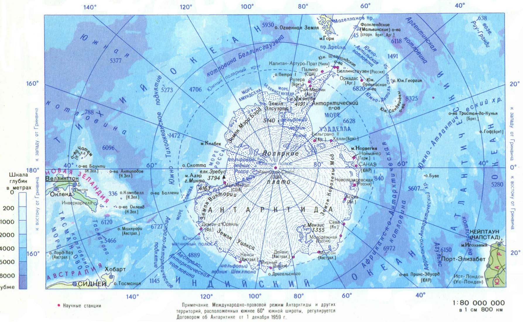
| Antarctic/Southern Ocean | |
|---|---|
| Arctic Ocean | |
| Atlantic Ocean |
|
| Indian Ocean | |
| Pacific Ocean |
|
| Endorheic basins | |
| Others | |
| International | |
|---|---|
| National | |
| Other | |
Southern Ocean
View on GrokipediaDefinition and Boundaries
Historical Evolution of the Concept
The notion of a southern ocean surrounding a vast, hypothetical continent known as Terra Australis originated in ancient Greek geography, where philosophers like Ptolemy envisioned it as a counterweight to northern landmasses, enclosed by seas depicted on maps from the 2nd century CE onward.[7] This speculative framework persisted into the early modern era, influencing cartographic representations of southern waters as undifferentiated extensions of the Atlantic, Pacific, and Indian Oceans, often labeled variably such as Mer Magellanique or early forms of a "Southern Ocean" south of southern continents like Australia.[8] Empirical mapping during voyages from the 16th to 19th centuries gradually dispelled the mythical continent but retained fluid conceptions of southern seas tied to land boundaries rather than oceanographic features. Formal hydrographic definitions emerged in the 20th century through the International Hydrographic Bureau's (now Organization) Limits of Oceans and Seas. The 1928 first edition defined the Southern Ocean (also termed Antarctic Ocean) as bounded southward by Antarctica and northward by the southern coasts of South America, Africa, Tasmania, and Australia, marking the first standardized delineation based on geographic rather than speculative criteria.[9] The 1937 second edition revised these limits southward, incorporating feedback from member states to better reflect surveyed coastal extents.[10] However, the 1953 third edition omitted the Southern Ocean entirely, extending the southern boundaries of the Atlantic, Pacific, and Indian Oceans to Antarctica due to prevailing opinions that no consensus existed for a distinct ocean.[11] Early functional boundaries emphasized oceanographic discontinuities over fixed latitudes. The Antarctic Convergence—now termed the Antarctic Polar Front—a dynamic zone around 48°S to 62°S where cold, nutrient-rich Antarctic surface waters subside beneath warmer subantarctic waters, provided a natural delimiter based on temperature, salinity, and biological gradients observed in expeditions from the late 19th century.[12] This front, varying seasonally and longitudinally due to wind-driven upwelling and the Antarctic Circumpolar Current, underpinned informal scientific recognition of southern waters as distinct by the mid-20th century.[13] A 2000 draft by the International Hydrographic Organization proposed reinstating the Southern Ocean with a northern limit at 60°S, aligning with the Convergence's mean position and circumpolar continuity, though formal ratification stalled amid member disagreements.[14] This oceanographic rationale shifted emphasis from land-based to dynamic biophysical criteria, reflecting accumulated empirical data from profiling floats and satellite altimetry unavailable in earlier editions.International and Scientific Delimitation
The International Hydrographic Organization (IHO) proposed in its 2000 draft limits of oceans and seas that the Southern Ocean encompasses the waters south of the 60° parallel south latitude, forming a continuous circumpolar body surrounding Antarctica and coinciding with the Antarctic Treaty System's jurisdictional boundary.[2] This latitudinal demarcation excludes certain marginal seas, such as the Scotia Sea, which some interpretations treat as extensions of the Atlantic rather than integral to the Southern Ocean proper.[15] However, this definition remains a draft, unratified by all member states due to ongoing debates over fixed versus dynamic boundaries, with the IHO having previously recognized and then repealed a Southern Ocean designation in 1937 and 1953 editions of its limits publication.[16] Scientifically, the Antarctic Circumpolar Current (ACC) provides the primary physical criterion for delimiting the Southern Ocean, acting as a semi-permeable barrier that isolates Antarctic surface waters from subtropical gyres and defines its northern extent.[13] The ACC's core fronts, including the Subantarctic Front to the north and the Polar Front, demarcate this boundary, with the Polar Front positioned variably between approximately 50° and 60°S latitude depending on longitude and season, driven by wind forcing and topographic interactions.[17] This dynamic frontier, with mean transport exceeding 130 Sverdrups, prevents significant meridional heat and nutrient exchange, rendering the region hydrographically distinct.[18] The ACC's isolation underpins the Southern Ocean's status as a unique biogeochemical province, as outlined in Longhurst's ecological partitioning of global oceans into provinces based on productivity regimes and nutrient cycling.[19] Within the polar biome, the Southern Ocean corresponds to provinces south of the ACC, characterized by high silicate and nitrate levels, iron limitation, and seasonal sea-ice modulation of primary production, differentiating it from adjacent westerly or trade-wind biomes.[20] This classification emphasizes causal oceanographic processes over arbitrary lines, aligning with empirical observations from satellite altimetry and Argo floats that reveal the ACC's role in sustaining the region's overturning circulation and carbon sequestration.[21]National Perspectives and Disputes
Australia formally incorporated the Southern Ocean into its maritime boundary framework through the Seas and Submerged Lands Act 1973, which declared sovereignty over territorial seas and supported subsequent proclamations extending jurisdiction southward, reflecting national interests in resource management adjacent to the Australian Antarctic Territory.[22] [23] This early adoption, predating widespread international consensus, prioritized Australia's control over fisheries and potential hydrocarbon reserves in the encircling waters. The United States exhibited reluctance until the National Oceanic and Atmospheric Administration (NOAA) recognized the Southern Ocean in February 2021, delineating it northward to 60°S despite prior U.S. Board on Geographic Names endorsement of the name since 1999; this shift aligned with accumulating oceanographic data but followed national caution toward formalizing boundaries that could influence Antarctic Treaty interpretations.[24] [25] The United Kingdom, while referencing the Southern Ocean historically as in the 1834 South Australia Act, has sustained alignments with Atlantic, Indian, and Pacific divisions in official hydrography, contributing to uneven global acceptance amid geopolitical sensitivities over sovereignty. Definitions of the Southern Ocean frequently omit exclusive economic zones (EEZs) stemming from sub-Antarctic islands—such as Australia's Heard and McDonald Islands or France's Kerguelen Plateau—to emphasize treaty-governed or high-seas domains south of 60°S, thereby segregating national resource claims from the core ocean basin and fostering jurisdictional fragmentation.[26] [27] This exclusion highlights how domestic assertions of EEZs, extending up to 200 nautical miles from island baselines, intersect with broader Southern Ocean delimitations, complicating unified governance of krill fisheries and deep-sea minerals. Critics argue the 60°S parallel is arbitrary, coinciding with the Antarctic Treaty boundary rather than biophysical markers like the Antarctic Circumpolar Current, which varies latitudinally from about 41°S to 60°S and better delineates distinct water masses.[28] [16] This static line overlooks dynamic frontal systems, potentially inviting bilateral tensions in resource-rich zones where national boundary interpretations diverge, as evidenced by Australia-New Zealand maritime delimitations and unresolved overlaps near sub-Antarctic claims.[29]History of Exploration
Pre-Modern Speculations and Myths
In the 2nd century AD, the Greco-Egyptian geographer Claudius Ptolemy proposed the existence of Terra Australis Incognita, a massive southern continent extending across much of the Southern Hemisphere to balance the landmasses of the Northern Hemisphere, based on assumptions of global symmetry derived from limited equatorial observations rather than direct exploration. [30] [31] This hypothesis, outlined in Ptolemy's Geography, lacked empirical support and stemmed from theoretical geography prioritizing hemispheric equilibrium over causal evidence of land distribution influenced by tectonic processes. [32] Medieval European cartographers, influenced by Ptolemaic and Aristotelian texts, perpetuated depictions of Terra Australis as a vast, habitable realm in the southern temperate zone, often illustrated on maps with imagined coastlines and inland features suggesting fertility and potential wealth, though these representations remained speculative without voyages to verify conditions. [33] Such maps, including those from the 15th century onward, filled voids south of the Indian and Atlantic Oceans with undefined southern lands, reflecting a persistence of classical symmetry models despite the absence of navigational data from high southern latitudes. [34] The 16th-century voyages began challenging these notions through direct encounters with southern extremes. In 1578, during his circumnavigation, Francis Drake's fleet, after passing the Strait of Magellan, was driven southward by storms to approximately 57°S, where the crew observed extensive ice fields, floating icebergs, and frigid gales, marking the first documented European sighting of Antarctic-influenced waters and contradicting expectations of accessible, temperate southern territories. [35] Drake's chaplain, Francis Fletcher, recorded these harsh realities in logs emphasizing the "bitter cold" and navigational perils, providing empirical data that prioritized observed phenomena over prior theoretical constructs. [36] Similarly, in 1616, Dutch explorers Willem Schouten and Jacob le Maire, seeking a passage east of the Strait of Magellan, rounded Cape Horn at 56°S amid violent seas and cold currents, encountering barriers of wind and swell that hinted at broader icy obstructions rather than inviting continental shores, as detailed in their published account of persistent southerly gales and navigational hazards. [37] These expeditions' records, grounded in positional measurements and weather observations, initiated a transition from mythical terra incognita to evidence-based recognition of the Southern Ocean's formidable, ice-circumscribed nature, undermining unsubstantiated claims of balmy, resource-rich southern domains. [38] ![Theatrum Orbis Terrarum by Abraham Ortelius, World, 1572, depicting speculative southern lands as Terra Australis][float-right]Early Modern Voyages and Sealers
James Cook's second voyage from 1772 to 1775 represented the earliest systematic effort to probe southern polar waters, driven by the Royal Society's quest to confirm or refute a hypothetical Terra Australis. Departing Plymouth on 13 July 1772 aboard HMS Resolution and accompanied by HMS Adventure, Cook crossed the Antarctic Circle on 17 January 1773 at 66°36′ S, achieving the first recorded penetration beyond 66°30′ S latitude.[39] He repeated this feat twice more during the expedition, reaching as far south as 71°10′ S while circumnavigating the continent, meticulously charting the perpetual ice barrier but observing no landmass indicative of a navigable southern continent.[40] These privateering-like ventures, though state-sponsored, prioritized navigational data over territorial claims, highlighting the formidable ice pack's extent and the seasonal limits of access.[41] Cook's discovery of South Georgia in January 1775 ignited commercial exploitation, as the island's abundant Antarctic fur seals (Arctocephalus gazella) offered pelts prized for felting into durable hats amid European demand. British and American sealers, primarily from New England ports like Nantucket and Stonington, launched opportunistic voyages southward, establishing temporary camps on subantarctic islands south of the Antarctic Convergence around 55° S. By the late 1780s, organized sealing operations harvested tens of thousands of seals annually at South Georgia, with vessels enduring gales and bergs to beach parties that clubbed animals en masse.[42] The industry's profitability stemmed from low overheads—small schooners and rudimentary processing—and high returns, with a single pelt fetching up to 20 shillings in London markets by 1800.[43] The sealing boom escalated into the 1810s, peaking in the 1821–1822 season with approximately 100 vessels active in the Southern Ocean, driven by unrestricted access and competitive rushes to untapped rookeries. Sealers ventured progressively farther south, including to the South Shetland Islands discovered in 1819, confirming the economic feasibility of operations beyond the Convergence despite losses from shipwrecks and scurvy. However, unchecked slaughter—estimated at over 7 million fur seals by 1833—led to rapid depletion, with South Georgia yields plummeting from 100,000 pelts in 1801 to near zero by the mid-1820s, forcing shifts to elephant seals for oil and foreshadowing regulatory needs.[44] These ventures underscored the hazards of uncharted waters and predatory economics, yet validated the Southern Ocean's resources for private enterprise.[45]19th-Century Scientific Expeditions
James Weddell, a British navigator and sealer, conducted an expedition in 1822–1824 that penetrated to 74°15′S in open water during February 1823, performing depth soundings in the region now known as the Weddell Sea.[46] This privately funded voyage, motivated by sealing interests alongside geographical curiosity, provided early empirical data on southern latitudes and ice conditions, influencing subsequent state efforts.[47] State-sponsored expeditions in the late 1830s and early 1840s prioritized systematic data collection on magnetism, bathymetry, and continental extent, often intertwined with territorial assertions amid imperial rivalries. The French Antarctic Expedition under Jules Dumont d'Urville, departing Toulon in 1837 aboard Astrolabe and Zéléé, reached the Antarctic continent in January 1840, discovering and claiming Adélie Land for France after landing and sampling rocks—the first such geological collections from the mainland.[48][49] Concurrently, the United States Exploring Expedition (1838–1842), commanded by Charles Wilkes with six vessels, surveyed the southern Pacific and Antarctic margins, sighting extensive ice shelves and claiming a 1,500-mile coastal stretch as Wilkes Land on January 19, 1840, thereby affirming Antarctica's continental nature through hydrographic and coastal profiling.[50][51] The British Antarctic Expedition (1839–1843), led by James Clark Ross on HMS Erebus and Terror, advanced furthest in scientific coordination, charting Victoria Land, the Ross Ice Shelf, and associated volcanoes while conducting magnetic dip and variation observations to map global geomagnetism patterns, with data relayed via en route stations.[52] These missions collectively shifted focus from opportunistic sealing to structured oceanographic and geophysical inquiry, yielding initial soundings and current drift records that presaged formalized circulation models.[53]20th-Century Heroic Age and Beyond
The Heroic Age of Antarctic exploration, spanning roughly 1897 to 1922, featured endurance-testing voyages reliant on wooden ships, man-hauled sledges, and limited animal transport into the Southern Ocean's pack ice and coastal margins. Expeditions overwintered in makeshift huts amid temperatures dropping below -40°C, facing scurvy, frostbite, and logistical breakdowns from failing ponies or dogs, which contributed to exhaustion and at least 19 fatalities across 17 major efforts, including cardiac failures and exposure unrelated to polar combat but exacerbated by malnutrition and overexertion.[54][55] Robert Falcon Scott's British Antarctic Expedition (1901–1904) on the Discovery mapped 500 km of Ross Sea coastline and collected oceanographic data, while his Terra Nova expedition (1910–1913) reached the South Pole on January 17, 1912, via man-hauling after ponies perished, but the five-man party succumbed to starvation and hypothermia on the return, highlighting the inefficiencies of human-powered traversal over 1,500 km.[56] Roald Amundsen's Norwegian expedition (1910–1912) on the Fram succeeded in reaching the pole on December 14, 1911, using 97 dogs for efficient depoting and return, demonstrating superior causality in adapting Inuit techniques to Antarctic conditions.[57] Ernest Shackleton's Imperial Trans-Antarctic Expedition (1914–1917) epitomized survival amid catastrophe when the Endurance was trapped in Weddell Sea ice on January 19, 1915, and crushed on November 21, 1915, forcing the crew to camp on drifting floes before a 346 km open-boat voyage to Elephant Island and Shackleton's 1,300 km rescue trek across South Georgia, with zero losses among 28 men despite months of seal-based rations and hypothermia risks.[58][59] These narratives, while valorized for resilience, often understate the era's causal perils—primitive insulation, unreliable navigation, and vitamin deficiencies—from which success hinged on contingency rather than systemic preparation, contrasting empirical failures like Scott's with Amundsen's data-driven adaptations.[60] Interwar efforts bridged to institutional science, as in Douglas Mawson's British, Australian, and New Zealand Antarctic Research Expedition (BANZARE, 1929–1931), which conducted two summer voyages on the Discovery, charting 3,700 km of coastline, performing aerial reconnaissance with seaplanes to map Mac.Robertson Land, and collecting ocean sediments revealing Southern Ocean currents' role in upwelling nutrients.[61][62] The International Geophysical Year (IGY, July 1, 1957–December 31, 1958) marked a multinational pivot, with 12 nations establishing 48 bases around the Southern Ocean, including U.S. stations at McMurdo Sound and the South Pole, yielding seismic, auroral, and ionospheric data from over 40 sites that quantified ice sheet dynamics and ocean-atmosphere exchanges.[63][64] This cooperative framework, involving 67 countries globally, amassed empirical datasets on Southern Ocean salinity and circulation, free from territorial friction.[65] Following the 1959 Antarctic Treaty's entry into force in 1961, operations mechanized with tracked vehicles, ski-equipped aircraft, and diesel-powered vessels, enabling year-round access beyond 60°S and reducing human exposure to elemental hazards that defined earlier sledging relays.[66] Sustained bases like those at Dumont d'Urville and Halley facilitated routine ocean profiling, shifting from ad hoc survival to scalable logistics that prioritized data continuity over individual heroism.[67]Recent Research Missions (Post-2000)
The International Polar Year (IPY) 2007-2008 coordinated multidisciplinary expeditions in the Southern Ocean, including the GEOTRACES-IPY campaigns that conducted ship-based transects to map trace elements, isotopes, and nutrient distributions influencing global biogeochemical cycles.[68] These efforts deployed autonomous vehicles and collected proxy data from sediments and water columns to reconstruct paleoclimate variability, revealing connections between Antarctic Bottom Water formation and carbon sequestration.[68] Since the early 2000s, the ARGO array has expanded to over 4,000 profiling floats globally, with a dedicated Southern Ocean component providing real-time profiles of temperature, salinity, and oxygen down to 2,000 meters, despite challenges from sea ice coverage.[69] The Southern Ocean Carbon and Climate Observations and Modeling (SOCCOM) project, initiated in 2014, enhanced this network with 200 biogeochemical floats equipped with sensors for pH, nitrate, and dissolved oxygen, enabling empirical tracking of carbon uptake and upwelling processes that models often overestimate.[70] The Southern Ocean Observing System (SOOS), launched in 2011, integrates these platforms with vessel-based surveys to monitor circumpolar circulation, prioritizing data delivery to fill gaps in sub-ice and deep-water observations where sampling density remains low.[71] From 2023 to 2025, glider missions have targeted frontal zones and gyre interiors, such as CSIRO's deployment of three Slocum gliders from RV Investigator at 55°S to measure currents via acoustic Doppler profilers and assess Antarctic Circumpolar Current variability.[72] The BIOPOLE program's gliders, operating through March 2025, collected conductivity-temperature-depth data across the Scotia Sea to quantify mesoscale eddy contributions to heat transport.[73] Satellite altimetry missions, including those from the CryoSat-2 and Sentinel-3 series, have mapped sea surface height anomalies south of 50°S, exposing gyre contractions and steric height changes not fully captured by pre-2020 in-situ networks.[74] Empirical profiles from these platforms document a reversal in surface salinity trends since around 2015, shifting from freshening to modest increases south of 50°S, which has stalled projected deep-ocean CO₂ outgassing by stabilizing upper-ocean stratification against model-expected meltwater dilution.[75] [76] Under-ice sampling persists as a key challenge, with floats often parking subsurface to evade collision, limiting vertical resolution in polynyas where dense water formation drives global overturning.[77]Physical Characteristics
Geographical Extent and Topography
The Southern Ocean comprises the body of water encircling Antarctica, extending northward to 60°S latitude as delimited by the International Hydrographic Organization and aligned with the Antarctic Treaty System's jurisdictional boundary.[15] This extent spans approximately 20.3 million km², representing the waters south of the Antarctic Convergence where cold surface waters meet warmer subtropical waters.[78] Geologically, the ocean basin originated from the tectonic separation of Antarctica from South America around 30 million years ago, which opened the Drake Passage and facilitated the formation of a continuous circumpolar seaway.[79] Bathymetrically, the Southern Ocean features an average depth of about 4,000 meters, with most regions exceeding 4,000–5,000 meters due to the expansive abyssal plains and basins.[79] The maximum depth reaches 7,434 meters in the South Sandwich Trench, located at the southern extremity of the Scotia Sea subduction zone.[80] Continental shelves are generally narrow along sub-Antarctic islands but broaden significantly along the Antarctic continental margin, where they extend up to several hundred kilometers and slope into deep marginal basins shaped by glacial erosion and sediment deposition.[15] Prominent topographic features include active mid-ocean ridges and arcs, such as the Scotia Arc, which traces a subduction-related boundary between the South American and Antarctic plates, influencing the basin's irregular seafloor morphology through ongoing seafloor spreading and volcanic activity.[81] Beneath Antarctic ice shelves, recent sub-ice topography mapping via the Bedmap3 dataset reveals rugged bedrock with deep subglacial basins exceeding 2,000 meters below sea level in places, reflecting ancient tectonic rifting and isostatic adjustments from ice loading.[82] These features underscore the ocean's youth and dynamism, with bathymetry compiled from multibeam sonar and satellite altimetry data in initiatives like the International Bathymetric Chart of the Southern Ocean.[83]Major Seas, Basins, and Geological Features
The Southern Ocean's major marginal seas include the Weddell Sea, Ross Sea, and Bellingshausen Sea, which constitute deep embayments along the Antarctic continental shelf, influencing regional ocean circulation and ice dynamics. The Weddell Sea, situated between the Antarctic Peninsula and Coats Land, spans approximately 2.8 million km² and features a complex bathymetry shaped by rifting associated with Gondwana's fragmentation, including volcanic activity during its Eocene to Miocene development.[84][85] The Ross Sea, extending from Victoria Land to Marie Byrd Land, similarly reflects tectonic inheritance from continental breakup, with its floor marked by rift basins and basement highs.[86] The Bellingshausen Sea, west of the Antarctic Peninsula, hosts thinner ice cover and shallower margins compared to its counterparts, facilitating greater polynya formation.[86] Geological basins and features stem from plate tectonic processes initiated by Gondwana's breakup around 180 million years ago in the Jurassic, when rifting separated Antarctica from adjacent continents, opening proto-oceanic basins through seafloor spreading at mid-ocean ridges such as the Southeast Indian Ridge and Pacific-Antarctic Ridge.[87] Ongoing divergence produces abyssal plains and fracture zones, while convergent margins feature subduction at trenches like the South Sandwich Trench in the Atlantic sector. A prominent rift zone is the Australo-Antarctic Discordance, spanning 120° to 128° E along the Southeast Indian Ridge, where spreading rates slow to 60-70 mm/year, resulting in rugged topography, deeper bathymetry exceeding 3,000 m, and geochemical anomalies from Indian-type mantle depletion.[88] Ice shelves represent dynamic geological extensions of the Antarctic ice sheet into these seas, with the Ross Ice Shelf—the largest—covering roughly 487,000 km² as a floating platform up to several hundred meters thick, primarily fed by grounded ice streams but transitioning to ungrounded conditions at the shelf front, distinct from inland grounded ice by its response to oceanic undercutting.[89] Similar floating shelves, such as the Ronne-Filchner in the Weddell Sea, integrate with basin topography to buttress upstream ice flow.[86]Natural Resources and Geological Hazards
The Southern Ocean's primary exploitable biological resource is Antarctic krill (Euphausia superba), with an estimated standing biomass of approximately 300 million metric tons, supporting a fishery that yields 230,000 to 390,000 metric tons annually in recent years, dominated by krill catches.[90][91] This biomass, concentrated in key sectors like the Atlantic and Indian sectors, underpins a potential scalable source of protein and omega-3 lipids, given krill's high nutritional density and the ocean's capacity to sustain harvests well below precautionary limits set by the Commission for the Conservation of Antarctic Marine Living Resources (CCAMLR).[92] Deep-sea mineral deposits, including polymetallic nodules on abyssal plains at depths of 3,500–6,000 meters, contain economically viable concentrations of manganese, nickel, copper, cobalt, and rare earth elements.[93] These nodules form through slow accretion of metals from seawater and sediments, offering a prospective supply for battery and alloy production amid terrestrial resource constraints. Geological hazards in the Southern Ocean arise from its tectonic setting at the Antarctic Plate's convergence with surrounding plates. Seismic activity is prominent along the South Sandwich Trench subduction zone, exemplified by the August 12, 2021, earthquake sequence reaching magnitude 8.2, which generated a global tsunami detectable via deep-sea sensors.[94] This event, involving slow rupture over hundreds of kilometers, underscores the region's capacity for infrequent but high-magnitude intraplate and interplate quakes at depths up to 63 kilometers.[95] Massive iceberg calving from Antarctic ice shelves, such as Larsen C or Ross, routinely releases tabular bergs exceeding 1,000 square kilometers, creating drift hazards that can ground or collide with vessels and subsea installations over thousands of kilometers.[96] Rogue waves, amplified by katabatic winds descending from the Antarctic continent and interacting with the Antarctic Circumpolar Current, form through nonlinear wave focusing, with expeditions confirming heights up to 20–30 meters in extreme conditions.[97] These hazards demand robust risk assessment for any resource extraction, given the ocean's remoteness and severe weather amplification.Oceanographic Processes
Circumpolar Current and Convergence Zone
The Antarctic Circumpolar Current (ACC) constitutes the dominant zonal circulation in the Southern Ocean, encircling Antarctica eastward without interruption due to the absence of intervening landmasses. This configuration enables a continuous flow spanning over 20,000 km, distinguishing it from latitude-bound currents elsewhere. The current's mean volume transport reaches approximately 141 Sverdrups (Sv; 1 Sv = 10^6 m³/s), rendering it the strongest in the global ocean system, with values derived from direct measurements in passages like Drake Strait.[98] [99] The ACC's momentum arises primarily from Southern Hemisphere westerly winds exerting surface stress on the ocean, unimpeded by zonal barriers, which imparts eastward acceleration to the Ekman layer. In steady state, this wind forcing balances form drag from seafloor topography via bottom stress, while geostrophic adjustment propagates the flow vertically through Coriolis deflection countering pressure gradients across sloped isopycnals. Westerly-driven Ekman transport induces divergence poleward of the wind maximum, fostering upwelling of deep waters and contributing to the current's baroclinic structure, where denser Antarctic waters remain stratified southward.[100] [101] [102] The Polar Front, positioned variably between 48°S and 56°S (averaging near 55°S), delineates the primary convergence zone within the ACC, where colder, denser Antarctic surface waters subduct beneath warmer subantarctic waters, forming a dynamic boundary. This front, alongside the northward Subantarctic Front, demarcates latitudinal water mass regimes: the subtropical-influenced subantarctic zone northward and the polar domain southward, with convergence enhancing vertical mixing yet limiting meridional exchange. From fluid dynamic principles, the front's stability stems from geostrophic shear and Ekman pumping, which steepen isopycnals and isolate cold polar waters by constraining eddy-driven diffusion against the current's high zonal velocity.[103] [104] [105]Gyres, Upwelling, and Vertical Mixing
The Ross Gyre and Weddell Gyre constitute the primary subpolar gyres in the Southern Ocean, occupying the Pacific-Antarctic and Atlantic-Antarctic sectors, respectively, with diameters on the order of 2,000 km each. These anticyclonic features rotate clockwise in the Southern Hemisphere, driven by wind stress curl and interactions with the Antarctic Circumpolar Current, effectively shielding continental shelves from warmer offshore waters while promoting interior recirculation. In the Weddell Gyre, gyre margins exhibit localized upwelling of Circumpolar Deep Water, modulated by eddy activity and topographic steering, which contributes to heat fluxes toward the Antarctic margins. Similarly, the Ross Gyre facilitates upwelling through cyclonic wind patterns over its eastern limb, enhancing vertical nutrient transport in the Ross Sea sector.[106] Polynya formation within and adjacent to these gyres amplifies upwelling, as offshore Ekman transport and latent heat fluxes maintain open water amid surrounding sea ice, allowing persistent ascent of subsurface waters. The Ross Sea polynya, the largest Antarctic coastal polynya at approximately 500,000 km², relies on gyre-induced divergence to sustain upwelling rates exceeding 10 m/day in winter, drawing iron-bearing shelf waters that alleviate regional micronutrient limitations and drive seasonal primary production peaks. Weddell polynyas, including the Filchner-Ronne and Ronne, exhibit analogous dynamics, where gyre convergence fosters brine rejection and upwelling, linking physical circulation to dense shelf water export. Ekman divergence at Southern Ocean fronts, particularly the Antarctic Divergence zone around 60°S, further enforces broad-scale upwelling via wind-driven surface transport, with divergence rates on the order of 0.1–0.5 Sv per degree latitude, compensating for cross-frontal subduction.[107][108][109] Diapycnal mixing sustains these upwelling pathways, with contributions from tidal currents interacting with rough bottom topography and storm-forced near-inertial waves elevating diffusivity to 10^{-4}–10^{-3} m²/s near shelves and seamounts, compared to interior values below 10^{-5} m²/s. Such mixing erodes density gradients, facilitating the ascent of Antarctic Bottom Water (AABW) precursors and enabling their transformation into lighter modes, which integrates into the global overturning circulation. This process supports the export of approximately 10–15 Sv of AABW northward, where diapycnal diffusion with North Atlantic Deep Water (NADW) drives diffusive upwelling, closing the meridional loop and influencing global abyssal ventilation. Nutrient cycling benefits causally from this enhanced vertical exchange, as upwelled deep waters supply bioavailable iron and macronutrients, countering high-nutrient, low-chlorophyll conditions despite primary dust and glacial melt inputs.[110][111]Water Mass Formation and Global Connectivity
Antarctic Bottom Water (AABW), the densest water mass in the global ocean, forms primarily in the Weddell and Ross Seas through brine rejection during sea ice formation and interaction with ice shelf cavities, where dense shelf water sinks and spreads along the abyssal ocean floor, ventilating approximately 40% of the world's ocean volume.[112][113] This process contributes to the Southern Ocean's role as the primary source of bottom water, exporting cold, oxygen-rich water northward while facilitating the upwelling of warmer, nutrient-depleted deep waters.[114] Lighter intermediate water masses, including Subantarctic Mode Water (SAMW) and Antarctic Intermediate Water (AAIW), form north of the Antarctic Circumpolar Current in the Subantarctic Zone through wintertime convection and Ekman pumping, with SAMW occupying depths of 200-600 meters and AAIW extending to 1000 meters.[115] These waters are subducted equatorward, exporting low-salinity, oxygen-enriched properties into subtropical gyres and influencing mid-depth circulation in the Atlantic, Pacific, and Indian Oceans.[116][117] The Southern Ocean connects to the Atlantic Meridional Overturning Circulation (AMOC) via the interplay of AABW and North Atlantic Deep Water (NADW), where AABW upwelling in the Atlantic compensates NADW sinking, maintaining meridional heat transport; recent observations indicate this linkage persists despite variability in deep water properties.[118] Satellite data from 2015 onward reveal a reversal in surface salinity trends, with circumpolar increases defying prior freshening, linked to reduced sea ice export and altered precipitation-evaporation balances.[119] Empirical measurements show that despite model predictions of diminished CO2 uptake from freshening-induced stratification, the Southern Ocean continues sequestering anthropogenic CO2 at rates comparable to prior decades, as stalled freshening and persistent upwelling sustain vertical mixing and gas exchange.[120][75] This discrepancy highlights observational evidence overriding model assumptions of halted sequestration under ongoing density changes.[121]Modern Observation Techniques and Data Challenges
The Argo array, deployed globally since the early 2000s, provides autonomous profiling of temperature, salinity, and biogeochemical parameters in the Southern Ocean, with polar variants enabling under-ice sampling during winter months when traditional platforms are limited.[122][123] The GO-SHIP program conducts repeat hydrographic sections on decadal timescales, yielding high-resolution full-depth measurements of physical, chemical, and biological properties along key transects, serving as the sustained backbone for detecting changes in water masses and circulation.[124][125] Instrumented southern elephant seals, tagged under initiatives like the Marine Mammals Exploring Ocean Poles (MEOP), act as mobile platforms, diving to depths exceeding 2,000 meters to collect data on ocean structure, frontal dynamics, and sea-ice interactions in remote, ice-covered regions inaccessible to ships or standard floats.[126][127] Satellite altimetry complements in-situ efforts, with CryoSat-2 (launched 2010) delivering measurements of sea-ice thickness and volume, alongside steric height anomalies indicative of heat and freshwater content variations.[128][74] The Surface Water and Ocean Topography (SWOT) mission, launched in December 2022, offers high-resolution sea-surface height data to resolve geostrophic currents, eddies, and volume transports, including initial observations over sea ice to enhance flux estimates.[129][130] Persistent challenges include extensive sea-ice coverage, which during austral winter spans up to 18 million square kilometers and restricts access to roughly 80-90% of the domain seasonally, limiting ship-based and surface float deployments while complicating satellite retrievals of open-ocean properties.[131] Sparse spatial and temporal sampling in this dynamic region leads to aliasing of mesoscale variability in current estimates, where eddies and frontal meanders—prevalent in the Antarctic Circumpolar Current—can bias reconstructions without dense arrays.[132] Direct measurements reveal positive sea-surface temperature anomalies in 2024 across much of the Southern Ocean amid high interannual variability, underscoring the need for integrated observing systems to resolve signals from noise without reliance on model infilling.[133][134]Climatic Patterns
Seasonal and Regional Climate Variability
The Southern Ocean displays marked seasonal variability in atmospheric circulation and sea ice coverage, with austral winter maxima in sea ice extent averaging 18.5 million square kilometers, driven by radiative cooling and katabatic outflows from the Antarctic continent.[135][136] These katabatic winds, descending rapidly over steep coastal slopes, routinely exceed 100 km/h and locally surpass 300 km/h during intense episodes, enhancing surface heat loss and polynya formation that facilitate new ice growth.[137] In contrast, austral summer sees sea ice retreat to a climatological minimum of approximately 2.9 million square kilometers by late February, exposing open water and allowing greater solar insolation to warm surface layers.[136] Westerly winds intensify during this period, shifting poleward alongside storm tracks between 40°S and 65°S, which deepens the ocean mixed layer through enhanced Ekman pumping and upwelling.[138][139] Regionally, climate patterns diverge across sectors, with the Amundsen Sea exhibiting shelf water warming linked to variable wind-driven incursions of Circumpolar Deep Water, while the adjacent Bellingshausen Sea has shown episodic cooling amid stronger winds that compact sea ice against the coast.[140][141] These contrasts arise from semi-permanent low-pressure systems like the Amundsen Sea Low, which modulate local upwelling and heat exchange, with historical satellite records indicating a 20% sea ice decline in these sectors since the 1970s.[142] The seasonal Antarctic ozone hole, forming in austral spring and depleting up to 70% of stratospheric ozone by October, prolongs the polar vortex and amplifies tropospheric westerlies, thereby intensifying surface wind speeds and altering precipitation distribution over the ocean.[143][144] Long-term empirical records, reconstructed from Southern Hemisphere station pressure observations since 1884—including marine data assimilated into early indices—document natural oscillations in the Southern Annular Mode (SAM), a primary driver of westerly variability.[145][146] Positive SAM phases, characterized by deepened subpolar lows and reduced mid-latitude highs, correlate with poleward westerly shifts and strengthened circumpolar flow, evident in 20th-century data spanning multiple decades of ship-based and land station measurements.[147] These patterns underscore intrinsic atmospheric dynamics, with seasonal SAM amplitudes influencing wind regimes independently of stratospheric forcings in baseline observations.Role in Global Heat and Carbon Budgets
The Southern Ocean south of 50°S absorbs approximately 75% of excess anthropogenic heat entering the global ocean, primarily through subduction of surface waters and eddy diffusion into the interior. This uptake has intensified since the early 2000s, with observational data from Argo floats indicating that 60–90% of recent global ocean heat content increases occur in this region, driven by wind-forced upwelling and exposure of cooler deep waters to surface warming. For anthropogenic carbon dioxide, the Southern Ocean accounts for about 40% of the ocean's total uptake, equivalent to roughly 42 Pg C south of 30°S from 1870 to recent decades, facilitated by high solubility in cold waters and biological pumping despite seasonal outgassing.[148][149][150] The Antarctic Circumpolar Current (ACC) modulates meridional heat transport, with anomalous northward (equatorward) fluxes reducing warming near Antarctica by exporting heat from the subpolar zone, while Ekman drift and eddy processes balance poleward inputs. However, persistent stratification, strengthened by surface freshening from glacial melt and sea ice formation, restricts deep ventilation and limits the downward propagation of heat and carbon, confining much uptake to the upper ocean layers above 2,000 m. Upwelling along the ACC's northern flank exposes pre-industrial deep waters laden with respired carbon to the surface, promoting natural CO₂ outgassing that offsets roughly 20–30% of anthropogenic uptake on seasonal scales, though this is modulated by wind-driven divergence.[151][152][153] Recent observational studies from 2025 highlight how ongoing freshening enhances upper-ocean stability, forming a "lid" that suppresses upwelling of carbon-rich deep waters and sustains net CO₂ sequestration, countering model-based concerns of potential release from reduced overturning. This process has effectively locked away CO₂ for decades by inhibiting vertical mixing, with low-salinity lenses observed via shipboard and satellite data preserving subsurface carbon reservoirs against ventilation. Such dynamics underscore the Southern Ocean's role as a stabilizing buffer in the global carbon cycle, where empirical freshening trends outweigh projections of sink weakening from circulation slowdowns.[154][155]Empirical Trends vs. Model Predictions
Observed sea surface temperatures in the Southern Ocean have risen at rates of approximately 0.1°C per decade since the 1980s, with faster warming up to 0.33°C per decade in subantarctic zones based on Argo float and satellite data.[156][149] Climate models from CMIP6 ensembles frequently overestimate these trends, attributing discrepancies to underestimation of surface freshening's cooling influence on SST via enhanced stratification.[134][157] Surface salinity, previously declining due to ice melt and precipitation, exhibited a sharp reversal post-2015, with satellite observations documenting rapid increases linked to reduced sea ice formation and altered mixing.[158][159] This salinification contradicts model expectations of persistent freshening under anthropogenic forcing, as CMIP5 simulations underestimated historical freshening while failing to anticipate the shift's magnitude or timing.[160][75] Enhanced salinity promotes vertical mixing, potentially amplifying heat release to the surface but challenging projections of stratification-driven CO2 uptake slowdown.[161] Antarctic sea ice extent declined abruptly after 2015, with summer minima tying for second-lowest on record in 2025 at 1.98 million km², following record lows in 2023.[162][163] Models projected gradual decline but underestimated the 2016 transition's severity, often attributing variability to internal modes like the Southern Annular Mode rather than linear anthropogenic tipping.[164] Claims of Antarctic Circumpolar Current reversal lack empirical support, with transport estimates showing no directional shift despite salinity-driven mixing changes; sensational interpretations misrepresent data continuity.[165][166] Direct flux measurements indicate Southern Ocean CO2 uptake exceeds model estimates by up to 25%, with profiling floats revealing persistent sink strength despite sea ice losses.[167][168] Simulations overpredict uptake slowdown from freshening, as recent salinification has temporarily bolstered deep CO2 ventilation contrary to projections.[121] Natural variability, analogous to Pacific Decadal Oscillation influences on heat distribution, accounts for much interdecadal flux modulation beyond forced trends.[169] Skeptics cite ice core records showing CO2 lagging temperature by 200–1000 years during deglaciations, arguing models overstate radiative forcing causality while ignoring orbital and ocean circulation drivers.[170] Mainstream narratives, prevalent in academia despite institutional biases toward high-sensitivity assumptions, emphasize irreversible thresholds amid sparse Southern Ocean observations.[171]Biological Systems
Primary Production and Food Webs
Primary production in the Southern Ocean is dominated by phytoplankton, particularly diatoms, which form seasonal blooms primarily in regions with elevated iron availability, such as near sub-Antarctic islands, continental shelves, or areas of upwelling. The ocean's high macronutrient concentrations (nitrate and phosphate) contrast with low chlorophyll biomass in high-nutrient, low-chlorophyll (HNLC) waters, where iron limitation constrains production; experimental iron additions have demonstrated rapid bloom responses, confirming iron as the primary micronutrient bottleneck in open waters. Annual net primary production (NPP) south of 50°S is estimated at approximately 15.8 Gt C yr⁻¹, though values vary with methodological assumptions and spatial definitions, reflecting the region's contribution to roughly 15-20% of global oceanic NPP despite its productivity constraints. Silica limitation uniquely affects diatom growth, as frustule formation depletes dissolved silicate during blooms, often terminating production in summer and favoring smaller flagellates thereafter.[172][173][174] The pelagic food web channels this production through short, efficient trophic pathways, with herbivorous zooplankton like Antarctic krill (Euphausia superba) serving as a keystone species that aggregates and transfers energy from primary producers to higher trophic levels. Krill grazing on diatoms and other phytoplankton supports biomass export via fecal pellets and direct consumption by predators, sustaining populations of fish, seabirds, marine mammals, and squid; their swarming behavior enhances trophic efficiency by concentrating resources in pulsed blooms. Regional variations exist, with microbial loops dominating in iron-limited HNLC zones (favoring bacteria and protozoa) versus krill-centric webs in productive marginal seas.[175][176] Trophic dynamics balance bottom-up nutrient controls with top-down predation pressures; for instance, seals and other krill consumers impose density-dependent regulation, preventing overgrazing while stabilizing web structure against bloom variability. Empirical studies indicate that predator removals (e.g., historical whaling) amplified krill fluctuations, underscoring top-down influences on secondary production resilience. Adaptations such as antifreeze glycoproteins in psychrophilic organisms and lipid-based buoyancy in notothenioid fish enhance survival and foraging efficiency in sub-zero waters, linking primary biomass to sustained higher-trophic yields despite environmental extremes.[175][177]Key Fauna: Invertebrates, Fish, and Cephalopods
The Antarctic krill (Euphausia superba) dominates Southern Ocean mid-trophic invertebrate populations, with a circumpolar biomass estimated at 300–379 million metric tons, representing the largest biomass of any wild animal species on Earth.[178][179][180] These euphausiids form dense swarms that underpin the region's food webs, with densities enabling acoustic surveys to detect biomasses exceeding several million tons in localized sectors such as the eastern Indian Ocean.[181][182] Benthic invertebrate communities south of the Antarctic Convergence feature high densities of sponges (Porifera) and echinoderms, including sea urchins (Echinoidea), which contribute to habitat structuring on the continental shelf and slope.[183] Sponges and bryozoans form aggregations that support associated fauna, while urchins graze algae and sessile organisms, with at least 35 regular urchin species documented, 31 from shelf depths.[184] Among fishes, the Channichthyidae family (icefishes) exemplifies adaptive specialization to subzero waters, lacking hemoglobin and erythrocytes entirely—the only vertebrates to do so—relying instead on plasma-dissolved oxygen facilitated by the Southern Ocean's high solubility at low temperatures.[185][186] These notothenioids possess expanded antifreeze glycoprotein genes and elevated lipid content for buoyancy and energy storage, compensating for reduced oxygen transport efficiency.[185][187] Cephalopods in the Southern Ocean are predominantly oceanic pelagic squid, with key predatory species including the colossal squid (Mesonychoteuthis hamiltoni) and slender beaked squid (Lepidosella longimana, formerly Moroteuthis longimana), which prey on fish and crustaceans while serving as forage for higher trophic levels.[188][189] Approximately 70 cephalopod species occur, all squid lacking inshore forms like loliginids, with distributions concentrated south of the Antarctic Convergence.[190] Faunal endemism exceeds 50% for many invertebrate and fish taxa south of the Antarctic Convergence, defining a distinct Antarctic biogeographic province isolated by circumpolar currents, with cephalopod endemism particularly elevated among squid and octopods.[191][192][193] This isolation fosters unique evolutionary radiations, as evidenced by genetic adaptations in icefishes and restricted cephalopod ranges.[187][188]Marine Mammals and Seabirds
The Southern Ocean hosts abundant populations of pinnipeds, particularly crabeater seals (Lobodon carcinophaga), estimated at 10-15 million individuals, which dominate pack-ice habitats and undertake seasonal migrations tied to sea-ice extent.[194] Weddell seals (Leptonychotes weddellii), more coastal and fast-ice associated, number around 800,000 globally, with recent satellite-based surveys estimating approximately 202,000 sub-adult and adult females, indicating stable but regionally variable abundances linked to polynya persistence and prey availability.[195] Combined, Antarctic seal populations exceed 30 million, functioning as apex consumers that migrate northward in winter to access open-water foraging grounds while relying on krill (Euphausia superba) as primary prey.[196] Cetacean populations, depleted by mid-20th-century whaling, show variable recovery post-1966 commercial bans under the International Whaling Commission moratorium. Blue whales (Balaenoptera musculus), once numbering over 200,000 in Antarctic waters, have rebounded to an estimated 25,000 individuals, with acoustic detections indicating increasing presence in historical feeding grounds south of 60°S during austral summer.[197] Minke whales (Balaenoptera bonaerensis), less impacted historically, maintain populations in the millions, with 2020s passive acoustic monitoring revealing rising call rates in the Weddell Sea and Scotia Arc, challenging narratives of widespread overexploitation and suggesting resilience amid krill variability.[198] These baleen whales migrate from tropical breeding areas to Antarctic shelf edges, where upwelling supports dense krill swarms essential for their energy-intensive migrations. Seabirds, including penguins and procellariiforms, exhibit high abundances and extensive migrations as top predators. Adélie penguins (Pygoscelis adeliae) support over 3.79 million breeding pairs across 251 colonies, with satellite imagery censuses confirming population growth of 53% since prior estimates, driven by access to ice-edge krill foraging during chick-rearing.[199] Albatrosses (family Diomedeidae) and petrels (family Procellariidae), such as wandering albatrosses (Diomedea exulans) and Antarctic petrels (Thalassoica antarctica), are long-range foragers, commuting thousands of kilometers from sub-Antarctic breeding islands to exploit Southern Ocean fronts, with tracking data showing circumpolar movements exceeding 750 km per day during non-breeding seasons.[200] Debates persist on trophic cascades from potential krill declines, with empirical data indicating no clear predator population crashes despite regional krill variability, as seabirds adapt via flexible foraging to alternative prey like myctophid fish.[201] Recent abundance surveys underscore these species' role in structuring upper-trophic dynamics, with minimal evidence of system-wide collapse.Adaptations to Extreme Conditions
Organisms in the Southern Ocean exhibit specialized physiological adaptations to maintain cellular function amid subzero temperatures averaging -1.8°C, where water viscosity impedes molecular diffusion and risks membrane rigidity. To counteract this, marine species incorporate elevated levels of unsaturated fatty acids into phospholipid membranes, preserving fluidity essential for enzyme activity, ion transport, and oxygen permeability; for instance, Antarctic fish membranes show higher proportions of polyunsaturated fatty acids compared to temperate counterparts, enabling homeoviscous adaptation without phase transitions that could impair bilayer integrity.[202][203] High ultraviolet radiation penetration, exacerbated by seasonal ozone depletion over Antarctica reaching minima of 100 Dobson units in October, necessitates photoprotective mechanisms; Antarctic krill (Euphausia superba) accumulate mycosporine-like amino acids (MAAs) such as asterina-330 from dietary algae, which absorb UV-B wavelengths (280–315 nm) and dissipate energy as harmless heat, preventing DNA damage in transparent exoskeletons and embryos.[204][205] In regions of periodic low oxygen due to stratification or ice cover, notothenioid fishes sustain aerobic metabolism through a conserved hypoxia-inducible factor-1 (HIF-1) pathway, inducing genes for erythropoiesis and glycolysis despite insertions in HIF-1α that might otherwise blunt response; this molecular robustness, coupled with inherently low metabolic rates (Q10 values around 2 versus 2.5–3 in temperate fish), minimizes hypoxia risk in waters where oxygen solubility exceeds 10 mg/L at 0°C but demand persists.[206][207] Reproductive strategies align with annual sea ice dynamics, where advance and retreat cycles—extending to 20 million km² in winter—affect primary production peaks; krill females synchronize spawning from November to March with ice melt, releasing embryos under receding pack ice to exploit under-ice algal blooms yielding up to 100 g C m⁻², ensuring larval survival amid nutrient upwelling.[208] Evolutionary divergence stems from post-Gondwanan isolation following continental separation around 34 million years ago, fostering radiations in endemic lineages like notothenioids (95% of biomass) via genetic bottlenecks that reduced diversity yet amplified cold-specialized traits; molecular phylogenies reveal low gene flow across the Antarctic Circumpolar Current, with divergence times aligning to Oligocene cooling and vicariance events.[209][210][211]Human Interactions and Economy
Commercial Fisheries and Krill Harvesting
The Commission for the Conservation of Antarctic Marine Living Resources (CCAMLR) oversees commercial fisheries in the Southern Ocean, applying a precautionary, ecosystem-based management framework that sets species-specific quotas informed by stock assessments and biomass surveys. Principal targets include Antarctic krill (Euphausia superba), the dominant species by harvest volume, and high-value demersal fishes such as Patagonian toothfish (Dissostichus eleginoides) and Antarctic toothfish (D. mawsoni). These fisheries operate south of 60°S, with catches documented through mandatory reporting and vessel monitoring systems to ensure compliance and minimize illegal, unreported, and unregulated (IUU) activities.[212][213] Antarctic krill harvesting, conducted mainly via midwater trawling in CCAMLR Subarea 48 and Division 58.4.2, reached 500,000 tonnes in 2024, marking it the largest single-species fishery in the region by tonnage.[214] In the 2024–25 season, catches hit the 620,000-tonne trigger level for key management units ahead of schedule, prompting an unprecedented early closure to avert localized depletion risks.[215][216] This volume equates to roughly 0.1–0.2% of the estimated precautionary biomass of 300–500 million tonnes, underscoring the fishery's conservative scale relative to krill's foundational role in the food web.[92] Products derived from krill—primarily meal for aquaculture feed, omega-3 oils, and nutritional supplements—yield an annual gross value of $250–900 million USD, with major operators like Aker BioMarine reporting $324 million in krill-related revenue in 2023.[217][218] Empirical data indicate potential for sustainable expansion to $1 billion or more without ecosystem disruption, as current harvests remain far below levels causing detectable population declines, though CCAMLR prioritizes spatial protections near predator colonies to buffer dependent species like penguins and seals.[219] Toothfish fisheries, prosecuted via longlines in exploratory and established areas (e.g., Subareas 48.3, 48.4, 88.1), produce lower volumes but higher per-unit value, with total annual catches across Patagonian and Antarctic species typically ranging 10,000–15,000 tonnes under strict quotas. For instance, the Ross Sea Antarctic toothfish TAC was set at 3,298 tonnes for 2024–25, while Patagonian toothfish in Subarea 48.3 (South Georgia) sustains yields informed by 25-year population modeling showing stocks at approximately 47% of unfished biomass—above depletion thresholds.[220] These fisheries faced severe IUU pressure in the 1990s–2000s, but CCAMLR's Catch Documentation Scheme has reduced illicit catches by over 90%, stabilizing legal operations.[221] Sustainability is evidenced by low bycatch rates: in krill trawls, non-target captures (primarily fish and tunicates) average under 1% of total catch, mitigated by fine-mesh codends and real-time monitoring; longline toothfish operations report seabird bycatch near zero through tori lines and night setting.[222][223] CCAMLR's data-driven quotas, derived from acoustic surveys and predation models rather than purely harvest-centric metrics, have maintained stock resilience amid climate variability, though some analyses critique the framework's conservatism for constraining economic output despite no observed overexploitation.[224][225]Shipping Routes, Tourism, and Infrastructure
Shipping in the Southern Ocean remains predominantly expeditionary, supporting scientific resupply and tourism rather than routine commercial bulk transport, due to extreme weather, ice coverage, and navigational hazards posed by the Antarctic Circumpolar Current (ACC). Optimal great circle paths between southern landmasses, such as from South America to Australia, often traverse latitudes near 50°S but skirt the ACC's core to avoid its high velocities—up to 4 knots—and associated storm intensification, prioritizing safer corridors along continental shelves.[226] Key logistical hubs include Hobart, Tasmania, which functions as a primary Antarctic gateway with dedicated wharves for outfitting vessels and handling cargo for multiple national programs, and McMurdo Station's Winter Quarters Bay, the southernmost operational port facilitating U.S. Antarctic logistics despite seasonal ice constraints.[227][228] Antarctic tourism, concentrated in the Peninsula region, has expanded rapidly, recording 74,401 visitors in the 2019-2020 austral summer prior to COVID-19 restrictions, surging to 122,072 in 2023-2024 amid post-pandemic rebound and demand for experiential eco-tourism via cruise ships and yacht charters. Forecasts indicate potential growth to nearly 500,000 annual visitors by 2033, driven by luxury operators and fly-cruise itineraries, though 98% of activity remains confined to over 600 designated sites to disperse impacts. The International Association of Antarctica Tour Operators (IAATO) enforces binding protocols, including vessel-based emergency response plans, wildlife viewing distances (minimum 5 meters for penguins), and site-specific limits (e.g., 100 persons ashore simultaneously), which have demonstrably reduced biosecurity risks and operational incidents despite inherent hazards like rogue waves and sudden whiteouts.[229][230][231] Supporting infrastructure encompasses over 70 year-round and seasonal research stations operated by 29 Antarctic Treaty signatory nations, reliant on annual resupply convoys of icebreaking ships that deliver approximately 10,000-15,000 metric tons of cargo, fuel, and personnel during the ice-free window from November to March. Vessels like Australia's RSV Nuyina, commissioned in 2021 with a 1.2-meter icebreaking hull, exemplify adaptations for traversing pack ice up to 1 meter thick while conducting en-route oceanographic surveys, highlighting the dual logistical-scientific role. This network amplifies strategic value for gateway economies—such as Australia's Tasmania and New Zealand's Christchurch—through multiplier effects from port fees, supply chain services, and tourism expenditures, contributing an estimated US$820 million annually to the global Antarctic tourism sector alone.[232][233][234]Untapped Resources: Minerals and Energy Potential
The continental margins of the Southern Ocean, particularly around Antarctica, harbor potential mineral resources including extensions of onshore coal seams and offshore placer deposits of heavy minerals such as ilmenite and magnetite, inferred from geological analogies with adjacent Gondwanan continents.[235] Seismic and geological surveys suggest sedimentary basins on these margins contain coal-bearing sequences, though no commercial deposits have been delineated due to exploration restrictions.[236] Polymetallic nodules, potentially enriched in manganese and cobalt, occur on abyssal plains, but concentrations in the Southern Ocean remain underexplored and secondary to equatorial Pacific fields.[237] Energy resources center on hydrocarbons within rift basins like the Weddell Sea and Ross Sea, where seismic data from limited surveys indicate source rock maturation sufficient for oil and gas generation, with prospects in Cretaceous and Tertiary sandstones.[238] The USGS estimates undiscovered technically recoverable oil and gas volumes in Antarctic offshore provinces, including these seas, based on geological modeling, though precise figures await further data.[239] Gas hydrates, methane clathrates in sub-seafloor sediments, show potential stability zones in the Weddell Sea under high-pressure, low-temperature conditions typical of the region.[240] Extraction faces comprehensive prohibitions under the 1991 Protocol on Environmental Protection to the Antarctic Treaty, which bans all mineral resource activities except scientific research, with no fixed expiration and amendments requiring consensus among 29 consultative parties.[241] This regime, enacted amid precautionary environmental concerns, has precluded systematic appraisal, yet empirical geological indicators and advancing subsea technologies—such as autonomous drilling viable by the 2020s—suggest reevaluation merits consideration against global energy shortages, as argued in resource policy analyses prioritizing empirical reserve data over indefinite moratoria.[242] Mainstream assessments from treaty-aligned institutions emphasize ecological risks, potentially amplified by institutional biases toward preservation, but causal analysis of basin analogs underscores recoverable potential warranting balanced scrutiny.[243]Environmental Management
International Treaties and Regulatory Frameworks
The Antarctic Treaty, signed on December 1, 1959, by twelve nations and entering into force on June 23, 1961, applies to the area south of 60°S latitude, encompassing the Southern Ocean, and establishes foundational principles for its governance. Article IV freezes all territorial claims, neither recognizing nor denying existing assertions by seven nations (Argentina, Australia, Chile, France, New Zealand, Norway, and the United Kingdom) nor permitting new claims or enlargements thereof, thereby preserving the status quo while subordinating sovereignty to collective international oversight. The treaty demilitarizes the region, prohibits nuclear explosions and radioactive waste disposal, and mandates freedom of scientific investigation with unrestricted exchange of data, while Article VII enables reciprocal inspections of facilities to verify compliance, though these remain cooperative and non-adversarial in practice.[244][245] Complementing the treaty, the Convention on the Conservation of Antarctic Marine Living Resources (CCAMLR), signed on May 20, 1980, and effective from April 7, 1982, targets the sustainable management of marine living resources in the Southern Ocean south of the Antarctic Convergence. Administered by the CCAMLR Commission, comprising 27 members as of 2023, it adopts an ecosystem-based approach to prevent overexploitation, setting catch limits for species like krill and toothfish through consensus decisions, which can delay or block measures if vetoed by any party. This framework extends treaty principles to fisheries but highlights enforcement challenges, as national implementation varies, creating jurisdictional inconsistencies that undermine uniform compliance.[246][247] The 1991 Protocol on Environmental Protection to the Antarctic Treaty (Madrid Protocol), signed October 4, 1991, and entering into force January 14, 1998, designates the Antarctic Treaty area as a "natural reserve devoted to peace and science," imposing comprehensive safeguards including environmental impact assessments for all activities and a ban on mineral resource activities other than for scientific research under Article 7. This indefinite moratorium, reviewable after 2048, binds all parties without opt-outs, though the United States and Russia—key consultative parties that reserve rights to future claims—have ratified it amid ongoing strategic interests in potential hydrocarbons and minerals, prompting concerns over post-review exploitation. The protocol strengthens inspection rights under Article 14 but relies on voluntary cooperation, with empirical reviews showing inspections conducted sporadically (e.g., 300+ since 1959 but uneven coverage), exposing gaps in real-time monitoring and enforcement against violations like unauthorized waste disposal.[241][248][249] Within this system, marine protected areas (MPAs) exemplify regulatory application, such as the Ross Sea Region MPA established by CCAMLR Conservation Measure 91-05 on October 28, 2016, spanning 1.55 million km² and prohibiting most fishing in core zones to safeguard biodiversity. Designation requires full consensus among members, enabling obstruction (e.g., repeated delays in other proposed MPAs like East Antarctica), while inspections remain non-binding, fostering sovereignty erosions as claimant states cede unilateral control over resources in overlapping zones to multilateral veto powers. Critics, including analysts from strategic think tanks, contend this structure embeds a preservationist bias—driven by environmental NGOs influential in treaty negotiations—prioritizing indefinite resource inaccessibility over verifiable developmental benefits, potentially constraining empirical assessments of sustainable extraction amid global energy demands.[250][251][252][253]Observed Human Impacts: Pollution and Overfishing
Microplastic particles have been detected in surface waters around the Antarctic Peninsula, with concentrations averaging 0.03 particles per cubic meter in a 2019 survey, primarily fibers and fragments transported via ocean currents from distant sources rather than local shipping.[254] Sediments near research stations like Rothera contain microplastics, linked to wastewater discharge and vessel activities, though overall inputs from ships and stations are estimated as negligible relative to global influx.[255][256] Deep-sea sediments in the Southern Ocean exhibit unexpectedly high microplastic abundances, up to thousands of particles per square meter, indicating accumulation despite low local generation.[257] Heavy metals, including mercury and cadmium, occur in coastal sediments near stations, attributable to fuel combustion and waste from human operations, but concentrations remain below acute toxicity thresholds for most biota based on 2024 analyses.[258] Oil spills in the Southern Ocean are infrequent, with notable incidents including the 2007 sinking of the MS Explorer cruise ship, which released approximately 185,000 liters of diesel fuel near the South Shetland Islands, impacting local penguin populations through oiling and ingestion.[259] Such events highlight risks from vessel traffic but represent isolated occurrences amid sparse shipping density. Antarctic krill biomass remains stable and substantial, with acoustic surveys in the southwest Atlantic estimating standing stocks exceeding 400 million tonnes as of recent assessments, far outpacing annual harvests of around 300,000–500,000 tonnes.[260][92] No empirical decline attributable to fishing is evident in these data, contrasting claims of overexploitation given the species' high reproductive capacity and vast distribution. Illegal, unreported, and unregulated (IUU) fishing for Patagonian toothfish peaked in the late 1990s but declined by over 99% after 2000 through trade documentation and enforcement, reducing estimated illicit catches from tens of thousands of tonnes to near zero by the mid-2010s.[261][262] Regulated fisheries now sustain stocks without signs of collapse, per length-frequency and tagging data. Southern Ocean biodiversity demonstrates resilience to historical exploitation, with baleen whale populations—depleted by 20th-century whaling—showing recovery trajectories; for instance, humpback whales have rebounded toward pre-whaling levels in some areas by 2020, supporting predator-prey dynamics without ecosystem-wide collapse.[263] Empirical metrics, including stable krill-dependent seabird breeding success post-whaling bans, indicate adaptive responses rather than irreversible degradation.[264]Debates on Conservation vs. Economic Development
The primary arena for debates on Southern Ocean conservation versus economic development is the Commission for the Conservation of Antarctic Marine Living Resources (CCAMLR), where member states must achieve consensus on measures like Marine Protected Areas (MPAs) amid competing national interests in fisheries and NGO advocacy for expansive no-take zones.[265] Pro-conservation arguments, advanced by organizations such as the Antarctic and Southern Ocean Coalition, emphasize MPAs' potential to enhance carbon sequestration via krill-phytoplankton dynamics and provide spillover benefits to adjacent fisheries, positing these as essential for ecosystem resilience against climate variability.[266] However, peer-reviewed assessments reveal limited demonstrated efficacy of existing Southern Ocean MPAs, with challenges including transboundary animal movements, persistent localized fishing, and high monitoring costs that often exceed verifiable biodiversity gains or fishery spillovers.[267] In contrast, proponents of economic development, including fishing-dependent nations like Norway and Russia, highlight krill harvesting's role in bolstering global food security through aquaculture feeds rich in omega-3s, with 2024 catches totaling approximately 500,000 metric tons—less than 0.03% of estimated biomass—under precautionary quotas that have sustained stocks without detectable ecosystem-wide depletion.[225] These advocates critique conservation proposals for overreliance on alarmist projections that undervalue adaptive harvesting's contributions to protein supply amid rising global demand, noting that empirical data from CCAMLR monitoring show no causal link between regulated extraction and predator declines when quotas align with natural variability.[260] Tensions often pit governmental stakeholders prioritizing verifiable economic outputs against NGOs, whose advocacy is sometimes accused of amplifying unproven risks while downplaying recent oceanographic observations, such as the post-2015 surface salinity increases documented in 2025 satellite and robotic data, which indicate complex feedback loops in ice formation rather than unidirectional collapse warranting prohibitive restrictions.[268] Cost-benefit analyses of Southern Ocean resource use consistently favor selective, science-based harvesting over blanket conservation, as the former yields direct socioeconomic returns—estimated at hundreds of millions annually from krill products—while avoiding the opportunity costs of foregone yields in a region where krill abundance supports scalable, low-impact extraction.[269] This empirical tilt underscores that managed development can coexist with environmental stewardship, provided decisions hinge on data rather than precautionary absolutism.[270]Geopolitical Dimensions
Overlapping Territorial Claims
Seven countries maintain territorial claims to sectors of Antarctica, which implicitly extend assertions of maritime jurisdiction into the adjacent Southern Ocean: Argentina, Australia, Chile, France, New Zealand, Norway, and the United Kingdom.[271] These claims, formalized between 1908 and 1940, consist of wedge-shaped sectors radiating from the South Pole, covering approximately 90% of the continent's coastline but leaving unclaimed areas such as the Marie Byrd Land sector.[272] The bases for these assertions vary, with Australia, France, New Zealand, Norway, and the UK primarily invoking discovery, symbolic acts of occupation (such as hoisting flags or establishing bases), and the sector principle derived from Arctic precedents; Argentina and Chile additionally rely on uti possidetis juris, extending colonial-era boundaries southward from their South American territories.[273] Empirical evaluation of these claims prioritizes effective control through continuous presence and administration over mere proclamation, as discontinuous or nominal occupation has historically yielded weak international recognition absent enforcement.[274] Overlaps occur primarily among Argentina, Chile, and the UK in the Antarctic Peninsula sector, where Argentina's 1939 claim (covering longitudes 25°W to 74°W) intersects Chile's 1940 assertion (53°W to 90°W) and the UK's 1908 sector (20°W to 80°W, later adjusted).[275] These tripartite overlaps, spanning about 1.6 million square kilometers, arise from divergent longitudinal definitions and contiguity arguments, with no resolution achieved through bilateral negotiations prior to 1959.[272] Australia's claim, the largest at 42% of Antarctica (160°E to 45°E, excluding the Adélie Land sector ceded to France), abuts but does not overlap others, while Norway's dual claims (one to Queen Maud Land, 20°W to 45°E, from 1939; another to Peter I Island) similarly avoid direct conflict.[275] In the Southern Ocean, these Antarctic sectors serve as baselines for maritime claims, including exclusive economic zones (EEZs) extending 200 nautical miles seaward, asserted by claimants such as Australia, Argentina, Chile, and France to regulate fisheries and potential hydrocarbon resources.[276] No formal territorial expansions into the ocean have been lodged since the 1959 Antarctic Treaty, though EEZ declarations function as proxies for resource control, with empirical precedence favoring states demonstrating patrol presence and licensing enforcement over unexercised proclamations.[277]| Claimant | Formalization Date | Longitudinal Sector | Key Basis |
|---|---|---|---|
| Argentina | 1940 (decree), 1939 (initial) | 25°W to 74°W | Uti possidetis, proximity, occupation |
| Australia | 1933 | 160°E to 45°E (excl. Adélie) | Discovery, sector principle, occupation |
| Chile | 1940 | 53°W to 90°W | Uti possidetis, proximity, contiguity |
| France | 1924 (Adélie), 1938 (exp.) | 136°E to 142°E; 49°S to 60°S lat. | Discovery (Dumont d'Urville, 1840) |
| New Zealand | 1923 | 160°E to 150°W | Sector from NZ dependencies, occupation |
| Norway | 1939 (Queen Maud), 1931 (Enderby) | 20°W to 45°E; 45°E to 69°E | Discovery (Amundsen, 1911), occupation |
| UK | 1908 (initial), 1917 (exp.) | 20°W to 80°W | Discovery, sector principle, occupation |